Download the high-resolution Corson County Map JPG files from the ZIP provided on this page. US 12 runs across the northern part of the county near Morristown, McIntosh, and McLaughlin, while Grand River bends through the broad interior and continues toward Lake Oahe on the east. The water and elevation views show an equally strong west-to-east contrast: higher ground dominates much of the west, the Grand River valley forms a lower corridor across the middle, and the terrain drops further near Lake Oahe. The map set also includes the smaller communities, creeks, and lakes needed to understand the large rural spaces between the main towns.
Corson County is easier to read when US 12 and Grand River are treated as two different geographic guides. The highway organizes the northern settlement pattern; the river organizes much of the interior landscape. Following those two references eastward toward Lake Oahe explains both the county’s road network and its relief without turning the article into four separate map descriptions.
Table of Contents
US 12 links the northern settlement corridor from Morristown to McLaughlin
On the general county map, US 12 is the most obvious east-west route near the northern boundary. Morristown sits on the western end of this corridor, McIntosh occupies the north-central area, and McLaughlin lies farther east. Route 65 extends south from the McIntosh area, while route 63 runs south of McLaughlin toward Little Eagle. These roads give the northern half of the county a clear framework before the smaller local routes are considered.
McLaughlin is the most prominent settlement label in the northeastern interior. Little Eagle is south of it, and Kenel and Wakpala are farther east near the Lake Oahe side of the county. Bullhead appears west of McLaughlin in the broad interior. Along the southern boundary, route marker 20 provides another long reference line, emphasizing how much land lies between the US 12 corridor and the county’s southern edge.
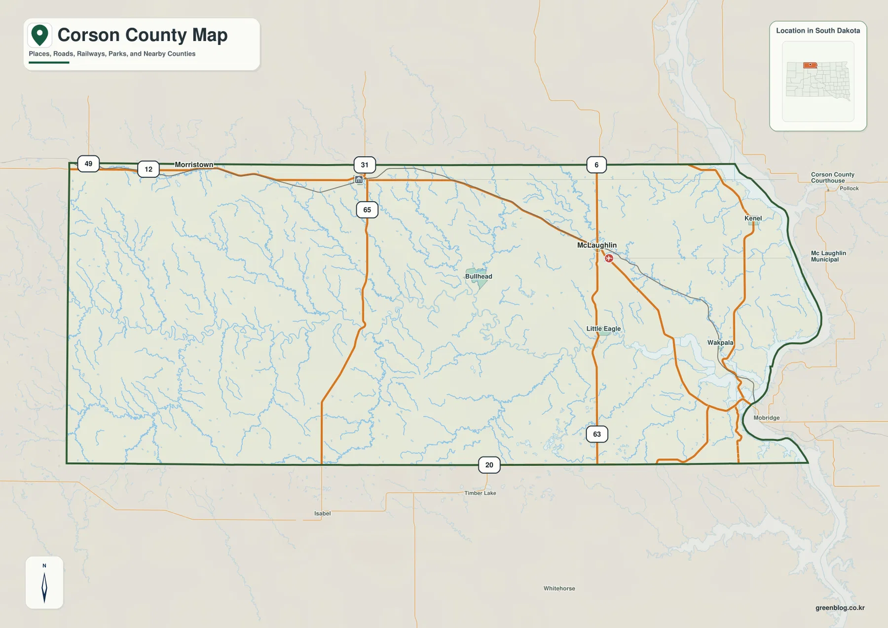
The eastern boundary is easy to recognize because it follows the irregular shoreline of Lake Oahe rather than one straight county line. Kenel and Wakpala sit close to this water-shaped edge, creating a strong contrast with the inland communities. The general map is the best place to find roads and settlements first, while the terrain-and-water view explains why the eastern edge has this shape.
McLaughlin, McIntosh, and Morristown provide three different northern reference points
The city-index image places McLaughlin in the northeast, McIntosh near the north-central part of the county, and Morristown toward the northwest. Rather than measuring mileage, the image is useful for comparing how far the three main labeled communities are spread along the northern part of Corson County. McLaughlin is ranked first, but the rank itself should not be confused with distance or current population.
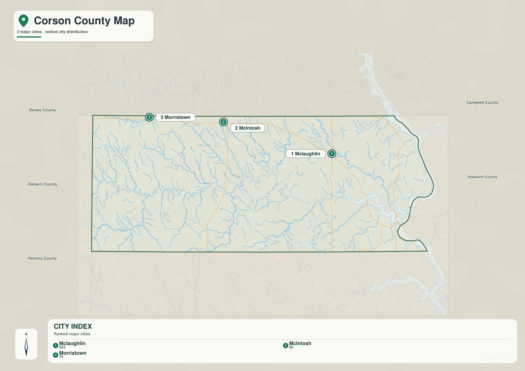
The printed CITY INDEX shows McLaughlin 683, McIntosh 80, and Morristown 76. This article treats those figures only as values printed on the supplied image, not as current population estimates. The latest population should be checked separately with the U.S. Census Bureau. Corson County’s official website and the South Dakota Unified Judicial System both list the county courthouse at McIntosh, giving the town an additional administrative role beyond its position on the map.
A broader county-specific fact is also important here. The U.S. Bureau of Indian Affairs states that the Standing Rock Indian Reservation encompasses all of Corson County in South Dakota. The supplied county maps do not draw a separate reservation boundary layer, so the road, water, and elevation explanations on this page should still be read according to the county map symbols actually shown.
Grand River crosses the interior before reaching the Lake Oahe side of the county
The terrain-and-water view makes Grand River one of the strongest natural references in Corson County. It enters from the west, bends repeatedly through the middle of the county, and continues east toward Lake Oahe. Dirt Lodge Creek approaches from the northwest, Black Horse Butte Creek comes in from the southwest, and Firesteel Creek rises from the south-central area toward the Grand River corridor.
North of Grand River, Rock Creek and Horse Creek are labeled among a dense network of smaller channels. Farther east, Oak Creek forms another strong line through the map, and High Bank Creek runs across the southeast. These waterways fill the large spaces that look relatively open on the road map and explain why the interior is visually much more complex in the water view.
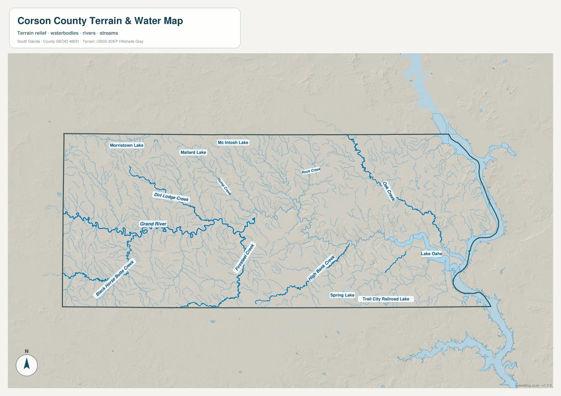
Several small lakes add northern and southern reference points. Morristown Lake, McIntosh Lake, and Mallard Lake appear near the northern portion of the county. Spring Lake and Trail City Railroad Lake are labeled closer to the south. Lake Oahe is by far the largest water feature on the page and occupies the eastern edge where the Grand River lowland reaches the reservoir.
This map is a location reference, not a live hydrologic product. It does not report current lake level, streamflow, flood risk, water quality, fishing conditions, or boating safety. Current field conditions around Grand River or Lake Oahe should be checked with USGS or local authorities.
Elevation falls from western high ground into the Grand River valley and Lake Oahe lowlands
The elevation map reports an actual county range of 488 to 816 meters and a mean of 636 meters. Browns dominate much of the western and northwestern county, indicating the highest broad terrain. Moving toward the center, the colors become lighter, and the winding Grand River valley appears as a lower green corridor cutting through the surrounding uplands. The eastern side near Lake Oahe is greener still.
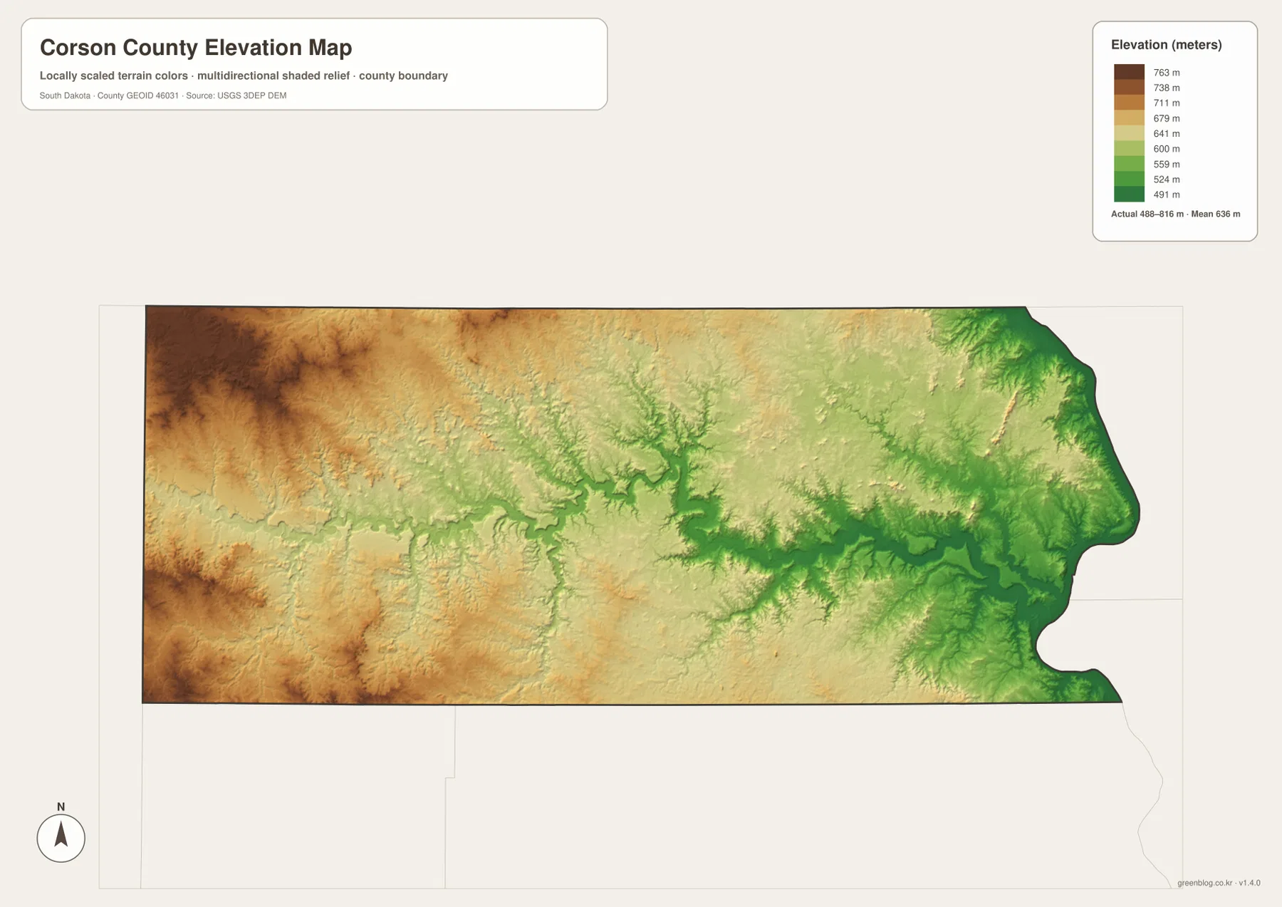
The relief surface matches the water map especially well. Grand River’s bends can be followed as a low band through the county, Oak Creek occupies another lower corridor in the east, and the Lake Oahe shoreline sits within the broadest low-elevation area. Morristown and the far western side are associated with much higher colors, while McLaughlin lies between the high western interior and the lower eastern drainage country.
The west-to-east difference is strong, but the county is not a single smooth slope. Uplands and small valleys repeat throughout the interior, and several creeks carve lower lines into otherwise higher terrain. The mean of 636 meters therefore hides a large internal range that becomes clear only when the colors are compared with the river network.
The 488–816 meter range is suitable for county-scale comparison, not parcel, building, or engineering measurement. A location-specific elevation should be checked with detailed USGS 3DEP data or professional survey information.
Follow McLaughlin south and east to connect roads, rivers, and relief
McLaughlin is a useful cross-map anchor. The county map places it near US 12 and route 63, with Little Eagle to the south and Kenel and Wakpala toward the Lake Oahe side. The water map then shows the many channels that descend toward Grand River and the eastern reservoir. On the elevation view, the same direction moves from moderate interior terrain toward the broad green lowlands near Lake Oahe.
McIntosh and Morristown provide a different comparison. McIntosh can be paired with route 65 and McIntosh Lake, while Morristown connects the northwestern settlement corridor with Morristown Lake and the higher western terrain. Following a single named place across roads, water, and elevation is a much clearer way to understand this large county than memorizing separate lists of map features.
The ZIP below contains the general county, city, terrain-and-water, and elevation maps as original high-resolution JPG files. Each image is 3638 × 2572 pixels and is suitable for printing, classroom handouts, presentations, or close viewing. Legal boundaries, live road conditions, current water information, flood decisions, and survey-grade elevation require current authoritative data in addition to these reference maps.
Frequently Asked Questions
Can Grand River and Lake Oahe be seen on the same water map?
Yes. The terrain-and-water view follows Grand River from the western interior toward Lake Oahe on the east and also labels Oak Creek, High Bank Creek, Firesteel Creek, Dirt Lodge Creek, and several small lakes.
Is McLaughlin 683 in the CITY INDEX a current population estimate?
This article treats McLaughlin 683, McIntosh 80, and Morristown 76 only as values printed in the supplied CITY INDEX. They should not be assumed to be the latest population estimates. Use current U.S. Census Bureau data when present-day population is important.
Can the 488–816 meter range be used as the exact elevation of a property?
No. The range is useful for broad county-scale comparison. A property-specific or engineering elevation should be checked with detailed USGS 3DEP data or professional survey information.
Map File Information
The Corson County general, city, terrain-and-water, and elevation views are packaged as high-resolution JPG files.
- Included Files: Use only the versions confirmed in the article and supplied images
- File Type: Use the confirmed download contents
- Intended Use: Printing, education, presentations, and map-based projects
Related Maps
Sources and References
The article is based first on the names, roads, water features, and elevation values visible in the supplied Corson County maps. These official sources provide additional county, Standing Rock Reservation, statistics, hydrography, and elevation reference information.
- Corson County official website
- U.S. Bureau of Indian Affairs – Standing Rock Agency
- U.S. Census Bureau QuickFacts – Corson County
- USGS National Hydrography
- USGS 3D Elevation Program
Green Map creates custom-edited map images using open geographic data sources such as geoBoundaries, Natural Earth, OpenStreetMap, and government open data.
These maps are edited visual materials, not raw data files, and are provided for education, documents, presentations, and graphic reference.