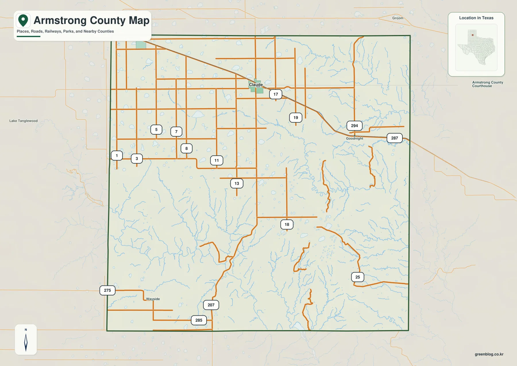
This Armstrong County map page covers one of the clearest terrain contrasts in the Texas Panhandle. Claude sits on the broad High Plains in the north-central part of the county, Goodnight lies to the east along U.S. 287, and Wayside marks the southwestern side near the Palo Duro country. The page combines county, city, water, and elevation views so you can follow roads and communities as well as the much deeper canyons to the south. A ZIP containing four separate high-resolution A3 JPG maps is available to download from this page.
The most useful way to understand Armstrong County is to look beyond the county boundary alone. Much of the north and northwest appears as a high, relatively even plateau, while the southern half is cut by branching creeks and steep drainage valleys associated with Palo Duro Canyon. That difference affects what you see on every map: roads are simpler on the open plateau, drainage lines become denser toward the canyon country, and the elevation map changes sharply from the higher brown tones to lower green terrain.
Table of Contents
Start with Claude and the northern High Plains
Claude is the best first reference point on the county map. It is positioned in the north-central part of Armstrong County, where U.S. 287 crosses the county and continues east toward Goodnight. State Highway 207 runs south from the Claude area toward the much rougher terrain in the lower half of the county. Wayside appears near the southwestern corner, providing a useful landmark on the opposite side of the county from Goodnight.
The map frame also names surrounding counties, including Carson, Potter, Randall, Donley, Gray, Briscoe, and Swisher. Those labels help place Armstrong County within the Panhandle without requiring a separate state map. The western side faces the Amarillo-area counties, while the southern edge approaches the broader canyon and caprock landscape. For route planning or regional comparison, this wider context is often more useful than a simple outline of Armstrong County by itself.
Why Claude stands alone on the city map
The city map is intentionally sparse. Claude is the only ranked major city shown, which reflects the county’s low-density settlement pattern rather than a lack of geographic detail. Large areas outside Claude are occupied by farms, ranches, small communities, and open country. This makes the city view especially useful when you want to identify the county seat quickly without the extra road labels that fill the general map.
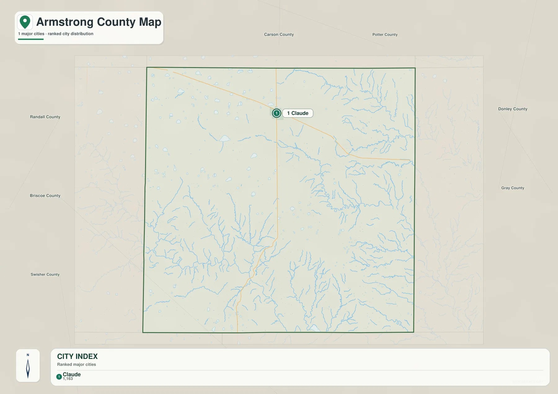
Claude’s role is also supported by the county’s history. The Handbook of Texas notes that the Fort Worth and Denver City Railway reached the area in 1887 and that Claude became the county seat when Armstrong County was organized in 1890. That history helps explain why the present map still feels centered on Claude even though the county covers a large area. Goodnight and Wayside remain useful place names on the reference map, but they do not appear as equivalent urban centers on the city map.
Follow U.S. 287 east and Highway 207 south
U.S. 287 is the easiest road to use for orientation across the northern part of the county. It passes through Claude and continues toward Goodnight, giving the two best-known northern communities a simple east-west relationship. If you are using the map for travel planning, regional geography, or a classroom exercise, locating U.S. 287 first makes the rest of the road network easier to understand.
State Highway 207 provides a very different geographic reference. It runs south from the high plateau toward the deeply dissected canyon terrain. The county map also shows road 285 near Wayside in the southwest. Taken together, these routes help separate three useful zones: the Claude and Goodnight corridor in the north, the open interior plateau, and the canyon-cut south where road alignments must work around much stronger relief.
Two Red River branches frame the drainage story
The water map gives Armstrong County a very different appearance from the city map. In the northeast, the Salt Fork Red River is one of the strongest labeled water features. In the southwest, the Prairie Dog Town Fork Red River follows the canyon country. Between them, named streams such as Mulberry Creek, Cottonwood Creek, and McCullum Creek branch through the eastern and central portions of the county.
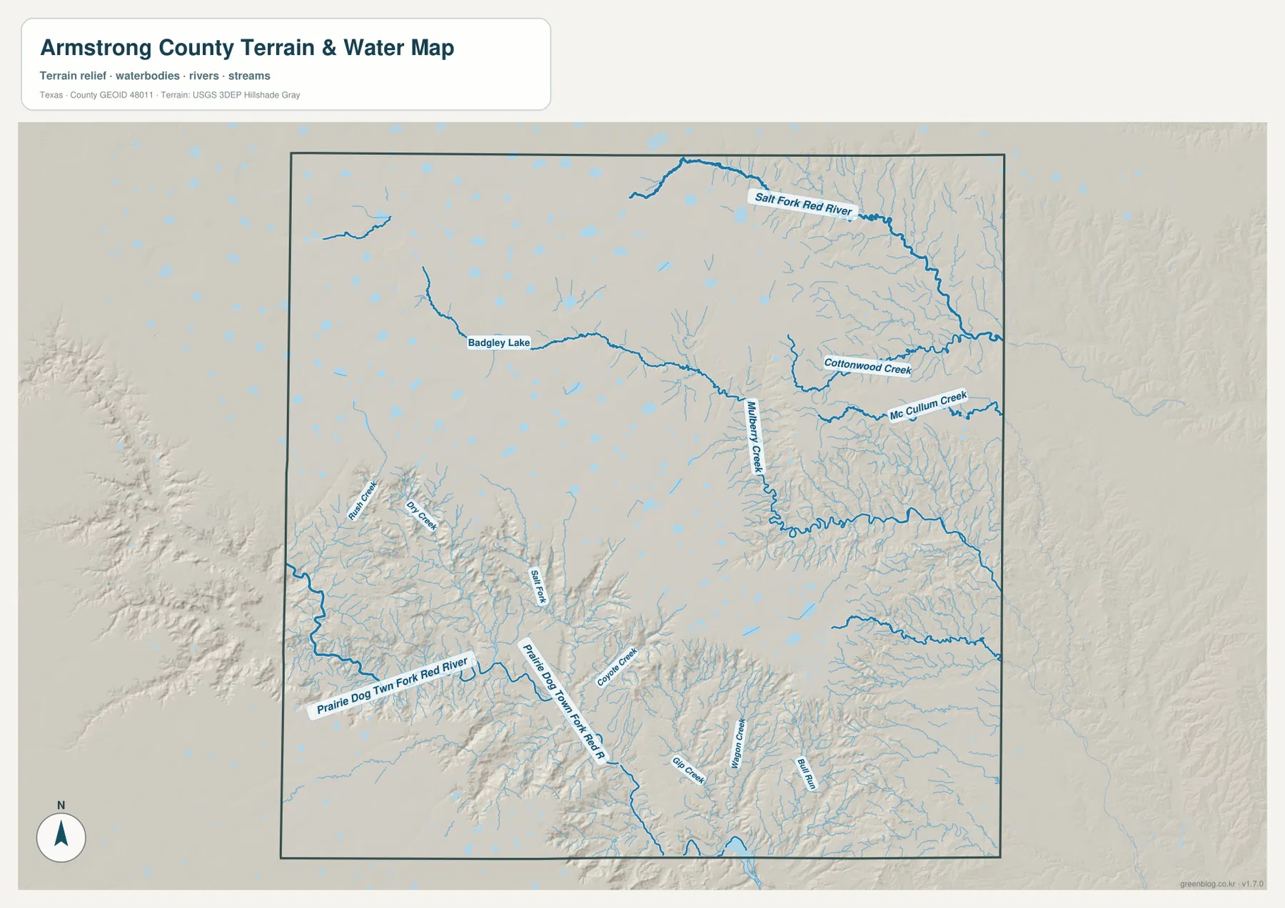
Badgley Lake is labeled in the western half, and numerous smaller water bodies appear across the plateau. The more important visual pattern, however, is the increasing density of drainage channels where the landscape becomes more deeply cut. The northwest has fewer pronounced valleys, while the south and east show many more branching channels. This is why the water map works well as a companion to the elevation map rather than simply as a list of rivers and lakes.
Elevation falls from the plateau into canyon country
The elevation map gives an actual county range of roughly 707 to 1,079 meters, with a mean elevation of about 958 meters. Most of the north and northwest is shown in higher brown and tan colors, indicating the broad High Plains surface. The south changes dramatically: green valleys cut into the plateau and create a network of lower terrain associated with Palo Duro Canyon and its tributary draws.
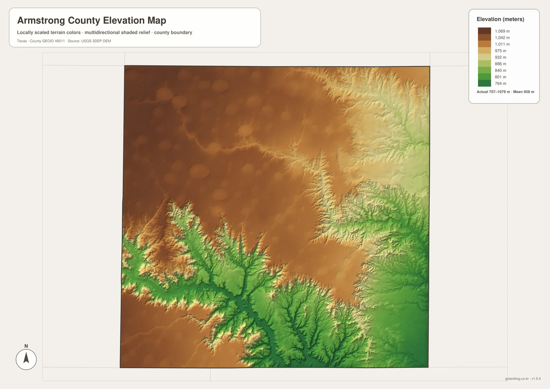
The terrain change is not limited to one narrow canyon. Several branches cut northward and eastward into the higher surface, creating steep edges between the plateau and lower drainage valleys. The southeastern portion also drops noticeably around the creek network. If you compare this map with the water layer, the lowest green corridors line up with many of the major channels, making the relationship between water and relief easy to see.
Goodnight and Wayside mark two different parts of the county
Goodnight is useful as an eastern landmark along U.S. 287. The Handbook of Texas ties the community to rancher Charles Goodnight and records its development after the railroad reached the area in the late nineteenth century. On a modern county map it is small, but its position east of Claude makes it valuable for understanding the northern travel corridor and the ranching history associated with this part of Armstrong County.
Wayside serves a different purpose. It sits in the southwest, close to the canyon landscape rather than the main northern road corridor. The Handbook of Texas places Wayside near Palo Duro Canyon and describes it as a rural community tied to stock raising and farming. When you move from Claude to Wayside on the map, you are also moving from the broad high plateau toward much more broken terrain, so the place name becomes a practical reference for both settlement and physical geography.
Which Armstrong County map should you use?
Use the county reference map when you need roads, communities, and county boundaries together. The city map is the cleanest choice for locating Claude and showing how little urban development is spread across the county. The water map is better for identifying the Red River branches, named creeks, small lakes, and the drainage network. For landform comparison, the elevation map is the strongest option because it makes the plateau-to-canyon drop visible at a glance.
For school projects or presentations, pairing the county map with the elevation map provides a clear explanation of why settlement and roads are easier to follow across the north than in the canyon country. For natural-resource or watershed study, the water and elevation maps work especially well together. The web images are convenient for reading on screen, while the downloadable files are intended for larger prints and offline use.
A practical way to read the county from north to south
Begin at Claude, then follow U.S. 287 east to Goodnight to understand the northern settlement corridor. Next, trace Highway 207 south and compare the road map with the elevation colors. The terrain becomes more irregular as channels cut into the plateau, and the Prairie Dog Town Fork Red River appears in the lower canyon country. Finally, look west toward Wayside to see how a small community can serve as a useful marker for the county’s southwestern edge.
Keep the elevation legend in view when making comparisons. The colors are scaled to Armstrong County’s own terrain, so a brown area is higher within this county and a green area is lower within this county; the colors should not be compared directly with a different county map without checking its legend. Here, the labeled range of 707–1,079 meters is the important reference for interpreting the contrast between plateau and canyon.
Frequently Asked Questions
Where is Claude on the Armstrong County map?
Claude is in the north-central part of Armstrong County along U.S. 287. It is the county seat and the only ranked major city highlighted on the city map, making it the easiest starting point for orientation.
How do Goodnight and Wayside relate to Claude?
Goodnight lies east of Claude along the U.S. 287 corridor. Wayside is in the southwest, much closer to the Palo Duro canyon country, so the two communities help mark very different parts of the county.
What is the elevation range shown for Armstrong County?
The elevation map shows an actual range of about 707 to 1,079 meters and a mean near 958 meters. The high plateau dominates the north and northwest, while the lowest terrain follows the deeply cut southern and eastern drainage valleys.
Sources and reference data
For county administration and local context, see the official Armstrong County website and the Handbook of Texas entry for Armstrong County. Boundary reference data is available through the U.S. Census Bureau TIGER/Line program. Hydrography can be checked with USGS National Hydrography, and elevation data with the USGS 3D Elevation Program.
Map File Information
The download contains four high-resolution A3 JPG maps of Armstrong County: county reference, city, water, and elevation. They can be used for printing, classroom work, presentations, and personal geographic reference.
- File Type: ZIP containing four high-resolution A3 JPG files
Related Maps
Green Map creates custom-edited map images using open geographic data sources such as geoBoundaries, Natural Earth, OpenStreetMap, and government open data.
These maps are edited visual materials, not raw data files, and are provided for education, documents, presentations, and graphic reference.