The Citrus County Map is easiest to read by locating inland Inverness and Gulf-side Crystal River first. Inverness is the county seat beside the broad Tsala Apopka lake-and-wetland district, while Crystal River sits on Kings Bay and connects to a maze of spring-fed rivers, shallow bays, and coastal marshes. Between them are communities such as Lecanto, Black Diamond, Citrus Hills, and Pine Ridge, and farther south the map reaches Homosassa and Homosassa Springs. The county map focuses on roads and place names, the city map simplifies the view around Inverness and Crystal River, and the water map brings the rivers, bays, creeks, and inland lake system forward. Download the high-resolution A3 JPG map ZIP from the file box below when you need the full-size versions of all three maps shown on this page.
Table of Contents
Inverness and Crystal River Show the County’s Inland-to-Gulf Contrast
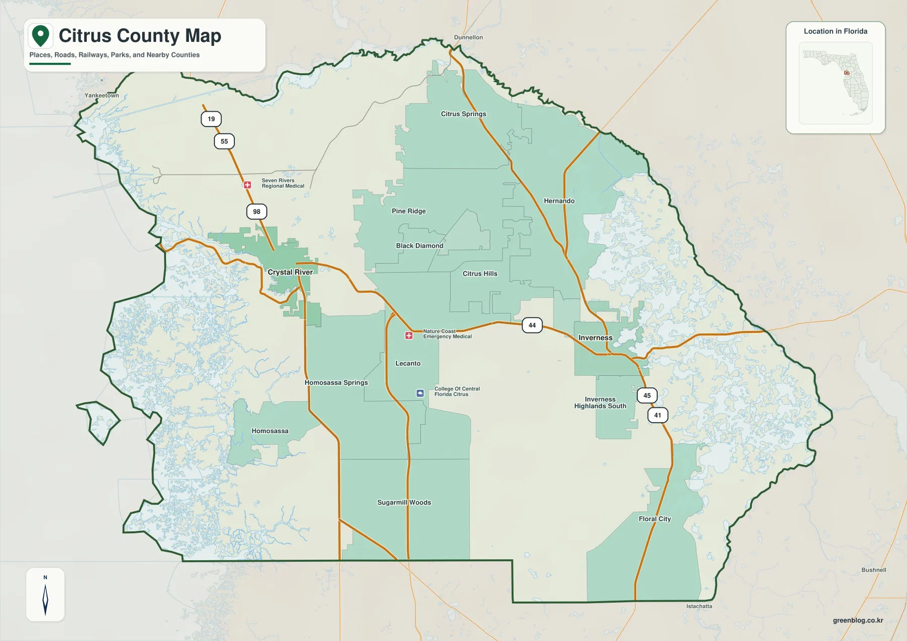
Citrus County lies on Florida’s west-central Gulf side, where inland lakes and wetlands sit surprisingly close to spring-fed coastal rivers. Inverness appears east of the county’s center and serves as the county seat. Around it, the map shows Inverness Highlands and the extensive water pattern associated with the Tsala Apopka Chain of Lakes. Crystal River occupies a very different position on the western side, immediately beside Kings Bay and the Crystal River waterway leading toward the Gulf.
The communities between those two places give the county a distributed rather than single-center pattern. Lecanto lies near the middle, with Black Diamond, Pine Ridge, and Citrus Hills farther north and east. Citrus Springs and Hernando are in the northern half, while Floral City marks the southern interior. Homosassa Springs and Homosassa occupy the southwest, where roads meet another spring-and-estuary landscape. Reading those areas as separate but connected parts of the county is more useful than imagining one continuous urban strip.
SR 44 Connects the Two Sides While US 19 and US 41 Run North-South
SR 44 is the most useful east-west reference on the map. It leaves Inverness, crosses the central part of the county through the Lecanto area, and reaches Crystal River. That route makes it easy to compare the inland lake district with the Gulf-side city without memorizing every local road. Along the west, US 19 provides the stronger north-south relationship between Crystal River and the Homosassa side. Farther east, US 41 passes through Inverness and continues toward Floral City in the south and the northern interior in the opposite direction.
The northwest side also shows US 98, and additional numbered routes connect Citrus Springs, Hernando, and the central communities. Rather than treating the map as a list of highway shields, start with three simple references: US 19 on the west, US 41 through Inverness, and SR 44 crossing between them. Once those lines are clear, Pine Ridge, Black Diamond, Citrus Hills, Lecanto, Homosassa Springs, and Floral City become much easier to place.
The general map also labels major local facilities, including Seven Rivers Regional Medical Center, Nature Coast Emergency Medical, and the College of Central Florida Citrus location. These labels help show where services sit relative to the road network, but the map is not intended to replace a street-level navigation product. It works best for county-scale orientation: finding which communities share a road corridor, which side of the county they occupy, and how those places relate to the major water systems.
The City Map Reduces the County to Inverness and Crystal River
The city map removes most of the secondary labels and emphasizes Inverness and Crystal River as the two main incorporated cities shown in the package. Inverness is placed in the eastern interior and Crystal River on the western side, making their separation very clear. County names around the edge—Levy, Marion, Sumter, and Hernando—provide enough regional context to understand where Citrus County sits without crowding the map with every local community.
The population material included in the package gives a Census Bureau estimate of 171,666 residents on July 1, 2025, compared with 153,843 people in the 2020 Census, an increase of 11.6 percent. Even with that growth, the county map does not show one continuous metropolitan belt. Crystal River and Homosassa form a western water-and-highway zone, Lecanto and several residential communities occupy the center, and Inverness anchors the eastern lake district. The city map is useful precisely because it strips away that complexity for a quick comparison of the two incorporated centers.
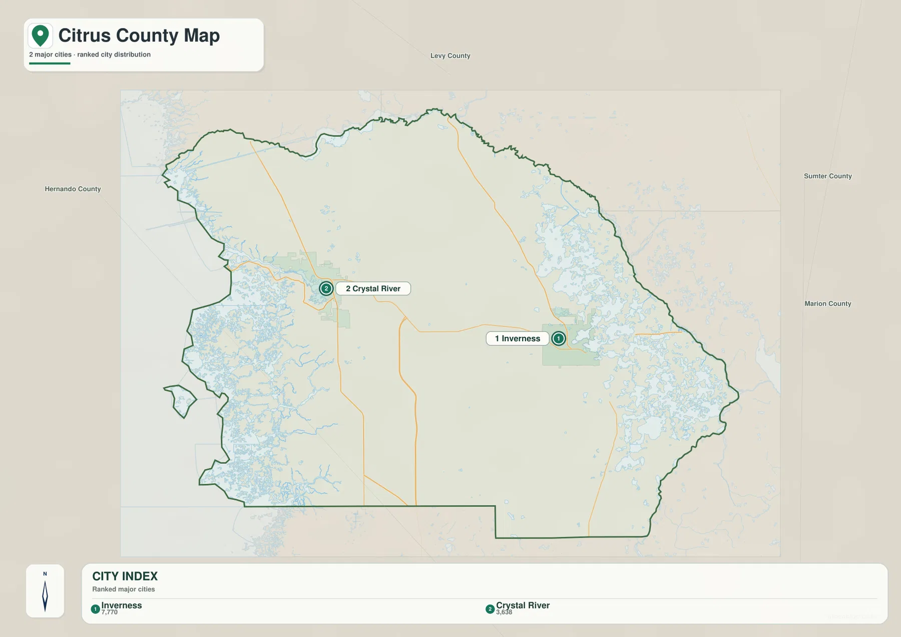
The two cities also sit in very different water settings. Inverness is associated with the inland Tsala Apopka lake complex, while Crystal River is immediately connected to Kings Bay and spring-fed water reaching the Gulf. For a short county profile or classroom handout, the city map can establish the settlement pattern first; the other two maps can then add roads, communities, and water features without forcing every layer onto one page.
Kings Bay Anchors the Crystal River Side of the Water Map
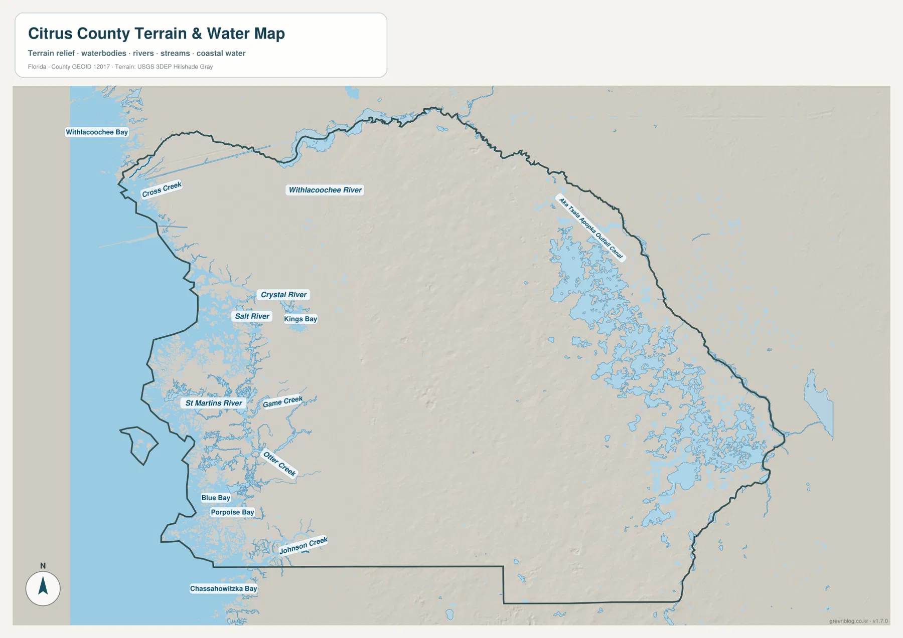
The water map makes the western coast much more detailed than the general road map. Kings Bay is labeled beside Crystal River, with the Crystal River channel extending west toward the Gulf. North of it are Withlacoochee Bay and the Withlacoochee River, while Salt River appears just south of the Crystal River area. Farther down the coast, the map labels St Martins River, Game Creek, Otter Creek, Blue Bay, Porpoise Bay, Johnson Creek, and Chassahowitzka Bay. Those names reveal a shoreline shaped by numerous shallow water bodies rather than one long, simple beach.
The U.S. Fish and Wildlife Service material included with the package explains that Crystal River National Wildlife Refuge was established in 1983 to protect Florida manatee habitat and includes spring habitat in Kings Bay. Warm spring water is especially important to manatees during colder periods, which is why Kings Bay is frequently discussed together with Crystal River and winter manatee use. On the map, that ecological importance fits the physical geography: the city sits beside a spring-fed bay rather than directly on an exposed open-Gulf shoreline.
The Eastern Side Is Defined by the Tsala Apopka Lake and Wetland System
The eastern half of the water map looks very different from the Gulf side. Around and north of Inverness, a broad pattern of interconnected water bodies spreads across the county, and an Tsala Apopka canal label appears along the northeastern side. The Southwest Florida Water Management District source included with the package describes the Tsala Apopka Chain of Lakes as a connected freshwater system organized around the Floral City, Inverness, and Hernando pools. The important point for a map reader is that this is not one isolated lake; it is a broad lake-and-wetland landscape with many connected sections.
That water system explains why Inverness and Floral City should be read together with their surrounding lakes rather than as ordinary inland towns on dry ground. US 41 runs through the eastern settlement corridor while water bodies sit close to both sides of the road in many areas. On the western side, the hydrology changes again as springs feed Crystal River and other waterways toward shallow Gulf estuaries. Few Florida county maps show such a clear transition from a large inland lake complex to spring rivers and then to a marshy Gulf coast within the same boundary.
The Nature Coast Shoreline Is More Marsh and Tidal Water Than Continuous Beach
Following the western boundary on the water map reveals bays, small islands, tidal creeks, and irregular river mouths. The Florida Department of Environmental Protection source included in the package describes the Crystal River area as part of a Nature Coast setting with marshes, tidal creeks, islands, shallow estuary water, and conservation habitat. That context helps explain why much of the land west of US 19 is not shown as a dense line of coastal development.
Crystal River and Homosassa are both western water-oriented communities, but they are separated by wetlands and separate river systems rather than joined by one continuous beachfront strip. This is an important distinction when using the county map for travel orientation or regional explanation. The general map is best for roads and communities, while the water map gives a much more accurate impression of the coast itself and the way rivers, bays, and marshes interrupt the shoreline.
Choose the Map by the Feature You Need to Explain
Use the county map when you need Inverness, Crystal River, Homosassa, Citrus Springs, Lecanto, road numbers, and neighboring areas in a single view. The city map is cleaner when the task is simply to compare Inverness with Crystal River. The water map is the strongest choice for Kings Bay, Crystal River, the Withlacoochee River, Salt River, the Gulf-side creeks and bays, and the inland lake system. Selecting the map that matches the question usually makes a report or presentation easier to read than placing every layer on the same page.
No elevation map is included in this package, so exact elevations, contour lines, or engineering-grade relief should not be inferred from these files. The water map is also not a flood-zone, legal-boundary, or navigation chart, and the road map does not provide live traffic. Within those limits, the three maps are useful for county profiles, classroom material, trip orientation, presentations, and documents that need a clear visual reference for roads, settlements, and waterways.
For printing or larger documents, use the ZIP below instead of relying only on the smaller web previews. The archive contains three A3 high-resolution JPG files corresponding to the county, city, and water maps used on this page. Each file can be used separately, so a project can include only the map that fits its purpose.
Frequently Asked Questions
How do Inverness and Crystal River differ on the map?
Inverness is the inland county seat beside the Tsala Apopka lake district, while Crystal River sits on Kings Bay on the western side. SR 44 provides the clearest east-west road connection between the two, so locating that route is a useful way to understand their relationship.
Why is Kings Bay associated with manatees?
The U.S. Fish and Wildlife Service source supplied with the package explains that Crystal River National Wildlife Refuge was established to protect Florida manatee habitat and includes spring habitat in Kings Bay. The warm spring water provides important cold-weather refuge, making Kings Bay central to the natural identity of Crystal River.
Does Citrus County have a long continuous sandy Gulf beach?
The water map shows a much more irregular Nature Coast shoreline with bays, tidal creeks, wetlands, islands, and river mouths. Crystal River and Homosassa sit within that marsh-and-estuary setting rather than along one uninterrupted developed beach.
Map File Information
Download one ZIP containing the three A3 high-resolution JPG files that match the county map, city map, and water map shown on this page.
- Included Files: County map, city map, and water map JPGs
- File Type: ZIP containing 3 JPG files
Related Maps
- Baker County Florida Map
- Blountstown, SR 20, and the Apalachicola River | Calhoun County Florida Map
- Brevard County Map
Sources
- U.S. Census Bureau QuickFacts — Citrus County, Florida — population estimate and 2020 Census reference
- Citrus County Government — county government and local information
- Southwest Florida Water Management District — Tsala Apopka Chain of Lakes — inland lake and wetland system reference
- U.S. Fish & Wildlife Service — Crystal River National Wildlife Refuge — Kings Bay and manatee habitat reference
- Florida Department of Environmental Protection — Citrus County — Nature Coast shoreline and coastal environment reference
Green Map creates custom-edited map images using open geographic data sources such as geoBoundaries, Natural Earth, OpenStreetMap, and government open data. These maps are edited visual materials, not raw data files, and are provided for education, documents, presentations, and graphic reference.