The Charlotte County Florida Map becomes much easier to understand once the Peace River is used as the first reference line. Punta Gorda, the county seat and only incorporated municipality, lies on the south side of the river near the head of Charlotte Harbor. Port Charlotte spreads across a much larger unincorporated area to the north, while Englewood and Manasota Key extend the county toward the Gulf side. I-75, US 41, and US 17 connect those populated areas with the inland Southwest Florida road network. Download the high-resolution A3 JPG map ZIP from the file box below when you need the full-size files; it contains the county, city, and water maps shown on this page.
Table of Contents
The Peace River Separates Punta Gorda from the Larger Port Charlotte Side
Charlotte County sits on Florida’s southwest Gulf Coast. Sarasota County is to the north, DeSoto County to the northeast, Glades and Highlands Counties farther east, and Lee County to the south. The west is very different from a simple straight coastline because Charlotte Harbor, Gasparilla Sound, islands, tidal channels, and shallow bays break the shoreline into several distinct pieces. The Peace River reaches the inner harbor near Punta Gorda and creates the clearest natural separation inside the county’s main population area.
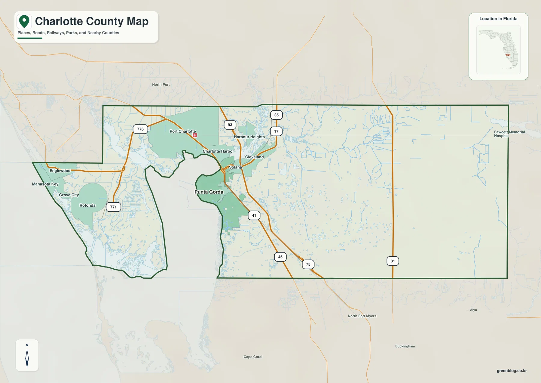
On the general county map, Punta Gorda is positioned south of the river and Port Charlotte is shown across a broad area to the north. Cleveland and Solana appear nearby, while Englewood, Grove City, Rotonda, and Manasota Key form a western group closer to the Gulf and harbor waters. Those labels matter because the county is not organized around one compact urban center. Instead, communities are divided by a large estuary, river crossings, wetlands, and long road corridors that lead toward Sarasota, DeSoto, Glades, and Lee Counties.
US 41 and I-75 Cross the River, While US 17 Turns Inland
US 41 and I-75 are the two easiest north-south references around the main population belt. US 41 passes directly through the Port Charlotte and Punta Gorda area, making it especially useful for seeing how the two communities relate to each other. I-75 lies farther east and serves a broader regional role between Sarasota County and Lee County. Both routes cross the Peace River, so the road map makes a simple point that is easy to miss on a small locator map: Punta Gorda and Port Charlotte are close, but the river makes the crossings themselves important.
US 17 leaves the Punta Gorda area toward the northeast and points toward DeSoto County and Arcadia. SR 776 provides the strongest westward reference from Port Charlotte toward Englewood, while the 771 route serves the Grove City and Rotonda side of the county. SR 31 runs north-south through the broad eastern interior. When those routes are compared, the developed western and central part of the county appears much more connected than the sparsely labeled east, where the map shows wider spaces between major roads and few large settlement names.
This road pattern also helps explain Charlotte County’s position between Gulf communities and inland Southwest Florida. Englewood and Manasota Key sit close to the Sarasota County line, Punta Gorda and Port Charlotte anchor the inner-harbor side, and SR 31 provides an inland orientation far from the coast. The county map is therefore useful for more than locating one town. It shows how coastal neighborhoods, river crossings, regional highways, and the rural eastern side fit together in the same county.
The City Map Shows Why Punta Gorda Stands Alone
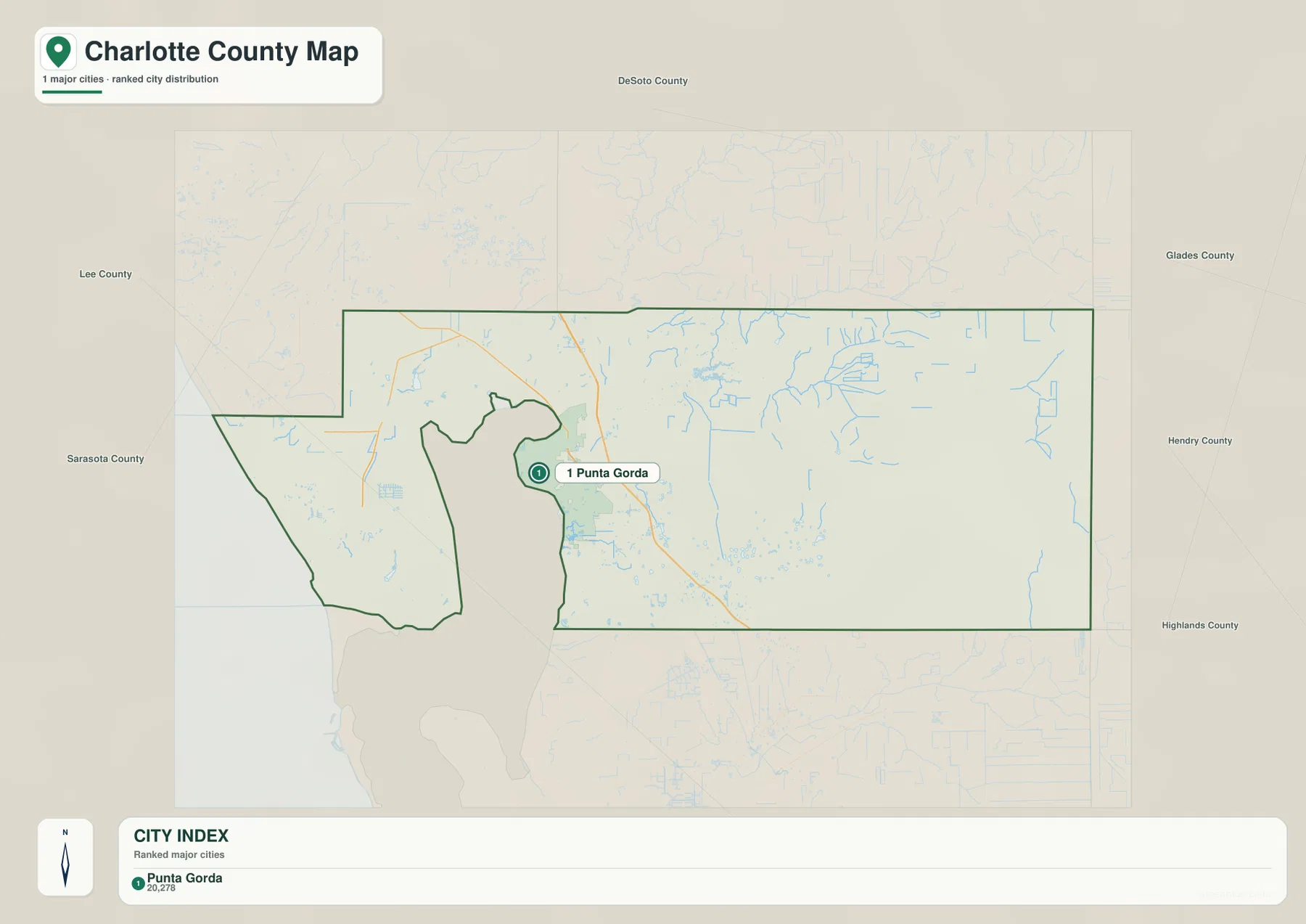
The city map is intentionally much simpler than the county map. It identifies one major incorporated city and highlights Punta Gorda in the center of the county outline. County names around the map—Sarasota, DeSoto, Lee, Glades, Hendry, and Highlands—provide regional orientation, but Port Charlotte does not appear in the ranked city list. That difference is not a sign that Port Charlotte is unimportant; it reflects the administrative distinction between an incorporated municipality and a large unincorporated community.
Charlotte County’s official information describes Punta Gorda as the county’s only incorporated municipality. Port Charlotte, by contrast, contains a large share of the county’s housing, retail, health services, and county service activity without having a separate city government. This is one of the most useful reasons to keep both the general map and the city map. The first shows the places people recognize in everyday life, while the second makes the legal municipal pattern immediately clear.
The population figures included with the package help put that pattern in context. The Census Bureau estimate cited in the existing material gives Charlotte County 217,212 residents on July 1, 2025, compared with 186,847 people in the 2020 Census. The same material lists 681.12 square miles of land and a 2020 density of 274.3 people per square mile. Growth at that scale does not produce a map full of incorporated cities because much of the population is distributed through unincorporated Port Charlotte, Englewood, Rotonda West, and other communities.
Charlotte Harbor Receives Water from Both the Peace and Myakka Rivers
The water map shifts attention away from roads and toward the estuary. The Peace River approaches from the northeast and reaches Charlotte Harbor beside the Punta Gorda area. From the northwest, the Myakka River enters near Tippecanoe Bay before reaching the harbor system. Charlotte Harbor is therefore more than an open coastal bay. It is a large estuary where freshwater from the rivers mixes with Gulf water, creating a shoreline made up of shallow bays, mangroves, tidal creeks, and island channels.
Several smaller names on the map make the coastal side easier to understand. Oyster Creek appears near the western edge, while Gasparilla Sound and Turtle Bay sit around the southwest harbor. Boca Grande Channel opens toward the Gulf, and Matlacha Pass is labeled south of the main harbor. Inland, Shell Creek, Myrtle Slough, South Prong Alligator Creek, and Jacks Branch show that the county’s water network continues far beyond the visible shoreline. Shell Creek is especially useful as an inland reference east of Punta Gorda, while the Peace River remains the major natural divider in the populated center.
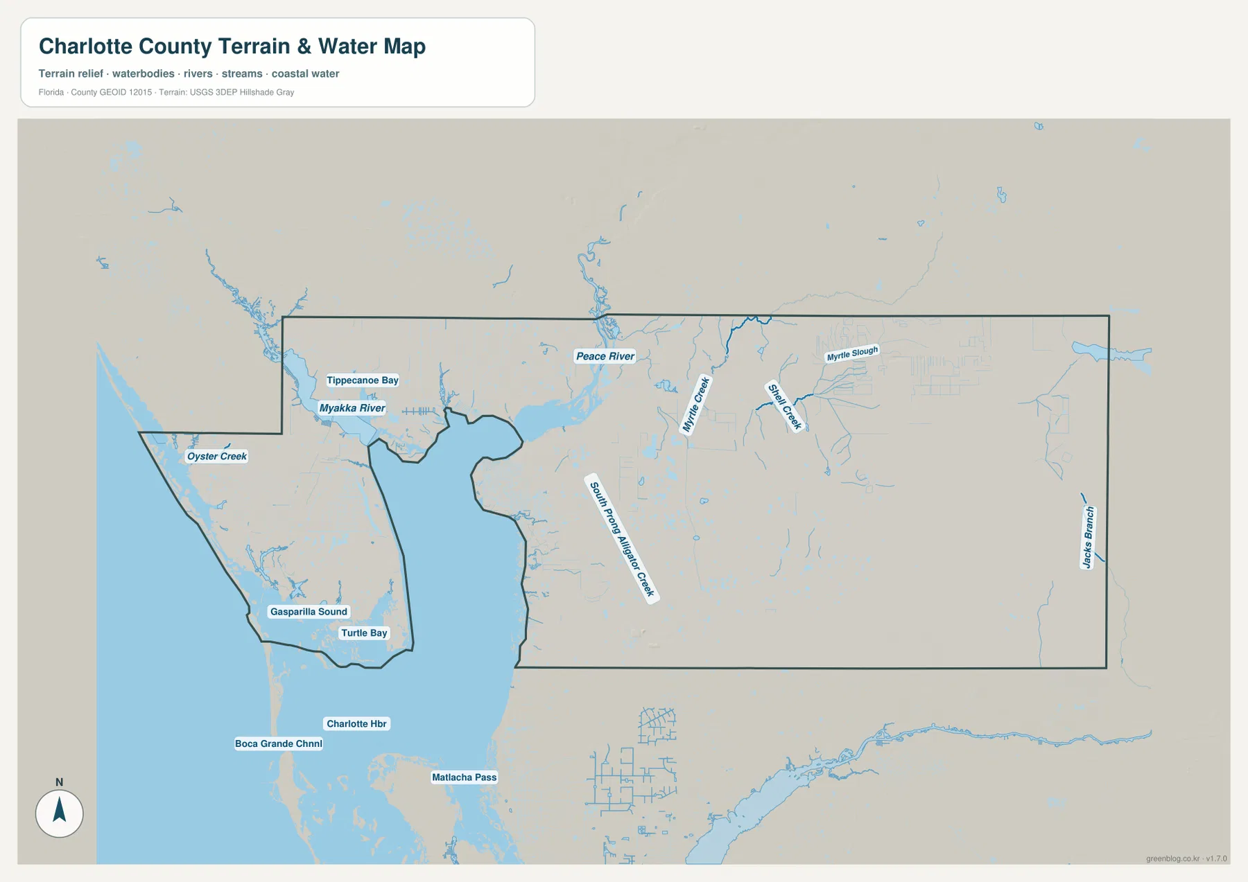
The Florida Department of Environmental Protection material listed in the package describes the Charlotte Harbor Aquatic Preserves as protected estuarine habitat with mangroves, seagrass beds, shallow bays, and tidal creeks. That helps explain why some waterfront areas that look relatively open on a road map are not simply vacant land waiting for development. Wetlands and protected natural areas occupy substantial parts of the harbor edge. Roads and housing often follow more accessible ground between canals, marshes, and preserved shoreline.
This map is a general geographic reference rather than a flood, parcel, engineering, or navigation product. It can show where major rivers, bays, creeks, and channels sit in relation to the county boundary, but it does not provide legal waterfront boundaries, flood-zone designations, current water depth, or survey-grade measurements. Those questions require the appropriate official hazard, parcel, or navigation data.
The Gulf-Side Communities Look Very Different from the Eastern Interior
Englewood, Manasota Key, Grove City, and Rotonda sit within a landscape shaped by Charlotte Harbor, Gasparilla Sound, islands, and tidal waterways. On the county map, roads and developed areas weave around water rather than forming a simple inland grid. Punta Gorda and Port Charlotte occupy the inner-harbor transition, where the Peace River, US 41, and I-75 bring the coast and inland road system together.
Farther east, the coastline disappears from view and the settlement labels become sparse. SR 31 provides one of the clearest orientation lines through this broad interior, while Shell Creek and smaller channels become more useful natural references. This contrast is important when describing Charlotte County. Calling it only a Gulf Coast county misses the large inland section, while describing it only through Punta Gorda ignores the much broader unincorporated communities and estuarine shoreline.
Choose the Map That Matches the Question You Are Trying to Answer
The county map is the quickest choice for seeing roads, communities, county boundaries, and the general shape of Charlotte Harbor at the same time. The city map is better when the question is specifically about incorporated municipal status because it makes Punta Gorda stand out without the distraction of every local place name. The water map is the strongest option for following the Peace River, Myakka River, Charlotte Harbor, and the smaller creeks and channels that shape the western half of the county.
This package does not include an elevation map, so exact elevations, contour lines, or engineering-grade height differences should not be inferred from these files. The road map does not show live traffic or construction, and the water map is not a flood-risk map. Within those limits, the maps are well suited to county profiles, classroom material, travel orientation, presentations, and documents that need a clear geographic reference.
For printing or larger documents, use the ZIP below rather than relying on the smaller web previews. It contains the three A3 high-resolution JPG files that correspond to the county, city, and water maps shown on this page. Each JPG can be used separately, so a project can include only the map that fits its purpose.
Frequently Asked Questions
Is Port Charlotte an incorporated city?
No. Port Charlotte is a large unincorporated community with major residential, commercial, and county-service functions, but it does not have a separate incorporated city government. Punta Gorda is Charlotte County’s only incorporated municipality.
What separates Punta Gorda from Port Charlotte?
The Peace River lies between the two communities before opening into Charlotte Harbor. US 41 and I-75 cross the river, so viewing the river and those two highways together is the easiest way to understand the relationship between Punta Gorda and Port Charlotte.
Is Charlotte Harbor simply an open Gulf bay?
It is a large estuary connected to the Gulf of Mexico. Freshwater from the Peace and Myakka Rivers mixes with saltwater, and the surrounding map shows sounds, bays, channels, mangrove shoreline, and tidal creeks rather than one simple open-water edge.
Map File Information
Download one ZIP containing the three A3 high-resolution JPG files that match the county map, city map, and water map used on this page.
- Included Files: County map, city map, and water map JPGs
- File Type: ZIP containing 3 JPG files
Related Maps
- Baker County Florida Map
- Blountstown, SR 20, and the Apalachicola River | Calhoun County Florida Map
- Brevard County Map
Sources
- Charlotte County, FL — Frequently Asked Questions — county government and incorporated-municipality context
- U.S. Census Bureau QuickFacts — Charlotte County, Florida — population, land area, and density reference
- Florida Department of Transportation — Charlotte County — major highway reference
- Florida DEP — Charlotte Harbor Aquatic Preserves — estuary and coastal habitat reference
Green Map creates custom-edited map images using open geographic data sources such as geoBoundaries, Natural Earth, OpenStreetMap, and government open data. These maps are edited visual materials, not raw data files, and are provided for education, documents, presentations, and graphic reference.