Carter County lies in southeastern Missouri, where Van Buren and the Current River provide the clearest starting point for understanding a rugged Ozark landscape. The general map places Van Buren, Ellsinore, Grandin, Hunter, and Fremont among routes such as U.S. 60, Route 103, Route 21, and Route 34, while the terrain and elevation maps reveal how deeply the river valleys cut into the surrounding ridges. The four original high-resolution JPG maps shown on this page can be downloaded together in one ZIP archive from the file box below. High-resolution map files are available for download in the section below.
The county does not have the broad, simple relief of a prairie area. Instead, narrow stream valleys branch repeatedly through the interior, and the Current River forms a strong low corridor through the western and central part of the county. Van Buren sits close to that river setting, while Ellsinore is farther east near the U.S. 60 corridor and Grandin is south of both. Those separated communities make more sense once the road, water, and elevation maps are compared rather than viewed as unrelated images.
The National Park Service identifies Carter County as part of Ozark National Scenic Riverways and locates the Big Spring Entrance Station south of Van Buren on Highway 103. That official park context reinforces what the maps show: roads in this county often work around steep-sided valleys instead of crossing a flat surface in straight lines. Starting with Van Buren and the Current River therefore makes it easier to understand the rest of Carter County, including the eastern routes toward Ellsinore and the lower tributary valleys in the southeast.
Table of Contents
Van Buren Sits beside the Current River Road Network
Van Buren is the strongest reference point on the general county map. Route 103 leaves the town toward the south and stays close to the lower Current River setting, while Route 34 crosses the northern interior and Route 21 provides a north-south connection farther east. Near Ellsinore, Route 333 and U.S. 60 become the most visible route markers. The road pattern is noticeably curving in many places, matching the broken terrain seen more clearly on the shaded-relief maps.
Fremont appears on the western side of the county, while Hunter and Grandin provide southern reference points. These places are not arranged along one continuous urban corridor; they are separated by ridges, small creeks, and winding local roads. A straight line between two labels can therefore be misleading for travel, because the actual route may have to follow a valley, cross a ridge at a favorable point, or bend around a drainage.
The county outline also helps with orientation. Its eastern edge steps inward and outward several times, whereas much of the northern and western boundary is simpler. The city-connection map labels Reynolds, Wayne, Butler, Ripley, Shannon, and Oregon counties around Carter County, giving a useful regional frame without turning the page into a full state map. Those neighboring labels are best treated as orientation references rather than a substitute for a detailed administrative-boundary product.
U.S. 60 is the clearest regional highway shown on the southeast side near Ellsinore. Van Buren, by contrast, is more closely associated with Route 103 and access to the Current River and Big Spring area. For trip planning, the map is useful for learning the overall direction of the routes, but current closures, work zones, detours, and road conditions should still be checked with live transportation sources before driving.
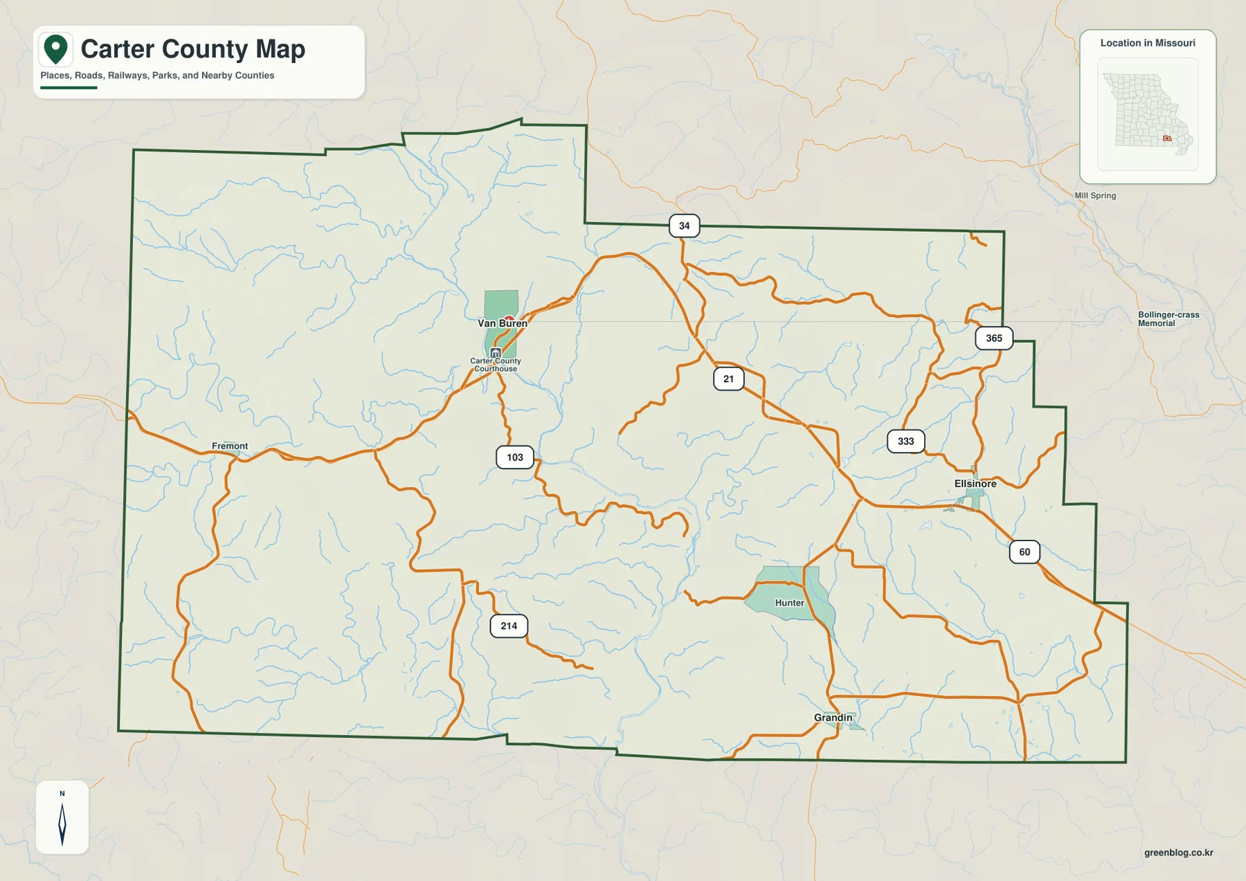
Use this map first when you need roads, town names, county boundaries, and nearby places in one view. Once Van Buren, Ellsinore, and Grandin are located, the other maps become easier to interpret because their streams, valleys, and elevation colors can be tied back to familiar road and settlement references. It is especially helpful for explaining why the county’s communities are spread across different parts of a rugged landscape instead of clustering along a single straight highway.
Ellsinore and Grandin Show How Far the Main Communities Spread
The city-connection map deliberately simplifies Carter County to three highlighted communities. Van Buren is the hub, Ellsinore is shown about 15 miles away to the east, and Grandin is about 16 miles away to the south. The map labels these as direct distances, so they should be read as straight-line measurements rather than driving mileage or estimated travel time.
That distinction matters in Carter County because the relief is highly dissected. The gap between two towns may look modest on a small county map, yet a vehicle route can be longer when it follows a creek valley or winds through a series of ridges. The connection map is therefore most useful for comparing relative position and direction, while the general road map provides the better frame for understanding how a trip would actually be routed.
The three towns also represent different parts of the county. Van Buren is tied closely to the Current River corridor and the lower Current River district of Ozark National Scenic Riverways. Ellsinore lies in the eastern road network near U.S. 60, while Grandin is positioned close to the southern edge. Together they show that Carter County’s settlement pattern is spread across separate valleys and road approaches rather than concentrated in one central plain.
Van Buren’s role is reinforced by official National Park Service material. The park’s Big Spring Entrance Station is south of Van Buren on Highway 103, and park headquarters are also located in Van Buren. That does not make the city map a tourism map, but it explains why Van Buren is such a practical anchor for describing roads, river access, and the location of the other communities.
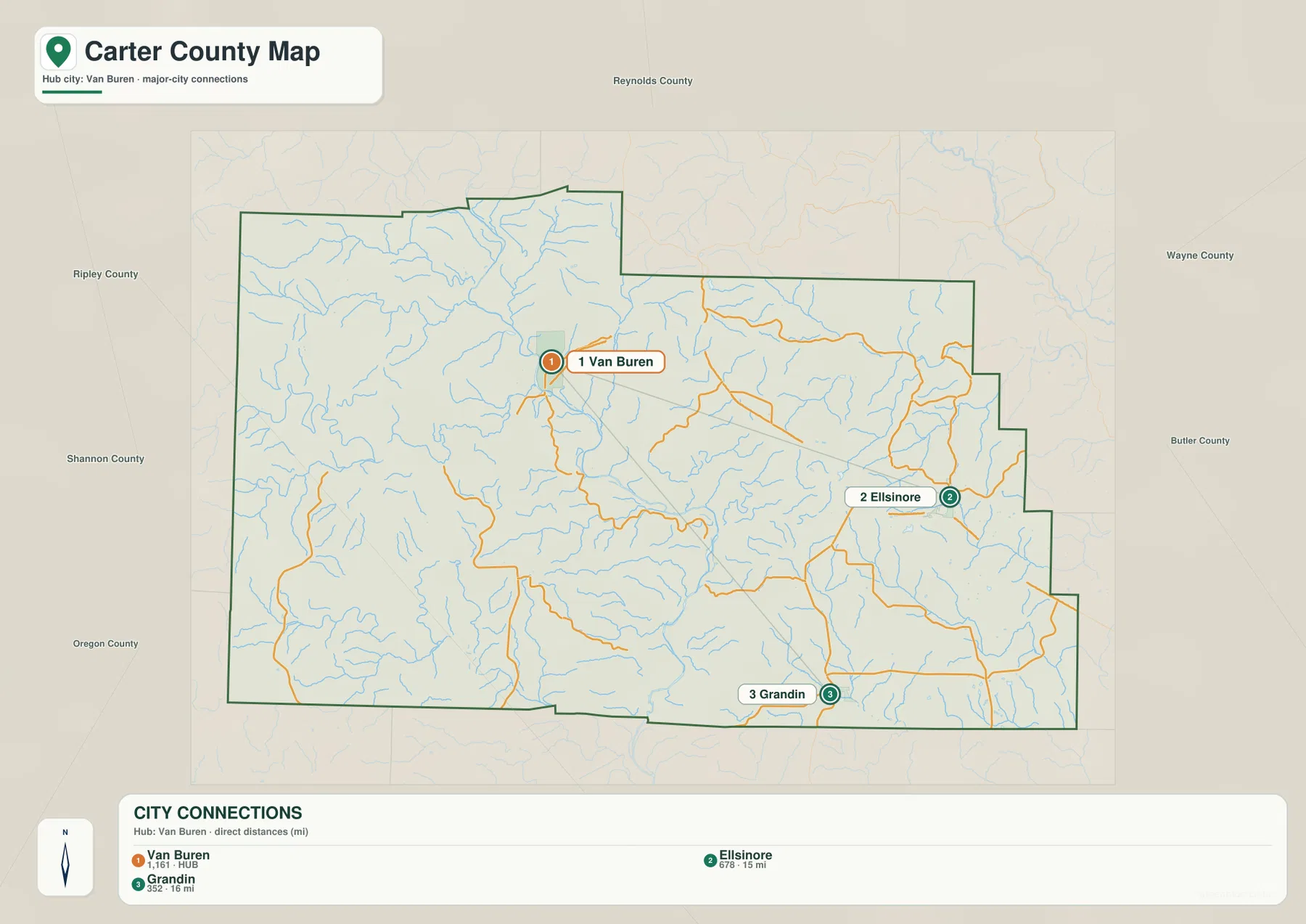
For a classroom slide or a quick location comparison, this simplified map is easier to read than the full road map because it removes many small labels. If the question involves U.S. 60, Route 103, Route 21, or local travel, switch back to the general map. Using the two together prevents the direct-distance labels from being mistaken for a recommended driving route.
Current River Dominates the West while Little Black River Branches Drain the Southeast
The terrain-and-water map makes the Current River the most prominent named water feature in Carter County. It enters from the northwestern side, bends through a deep valley, and continues southward through the county. Rogers Creek, Mill Creek, Pike Creek, Chilton Creek, and many smaller branches feed lower corridors around it. The shaded relief makes those tributary valleys stand out even where the blue stream lines are thin.
Big Barren Creek crosses the southwestern part of the map, while the southeastern drainage looks different from the Current River side. The Middle Fork North Prong Little Black River and the North Prong Little Black River run through the southeast with numerous short tributaries joining them. Carter County therefore contains more than one major drainage direction: the western and central landscape is organized around the Current River, while the southeast has its own network of valleys leading toward the Little Black River system.
Several smaller standing-water features are labeled as well, including Miller Lake, Elm Springs Lake, Pinewoods Lake, and Cotham Pond. They are much smaller than the river corridor, but they add useful detail and show that the county’s water geography is not limited to one channel. Seen with the relief background, the lakes, ponds, and tributaries occupy low pockets among a dense pattern of ridges.
The Current River also has a clear official conservation context. The National Park Service describes Ozark National Scenic Riverways as a protected river system that includes Carter County, and its visitor information identifies the lower Current River and Big Spring near Van Buren as major features of the district. The map on this page, however, is only a geographic reference. It does not show real-time river stage, legal water boundaries, navigable depth, flood insurance zones, or current recreation closures.
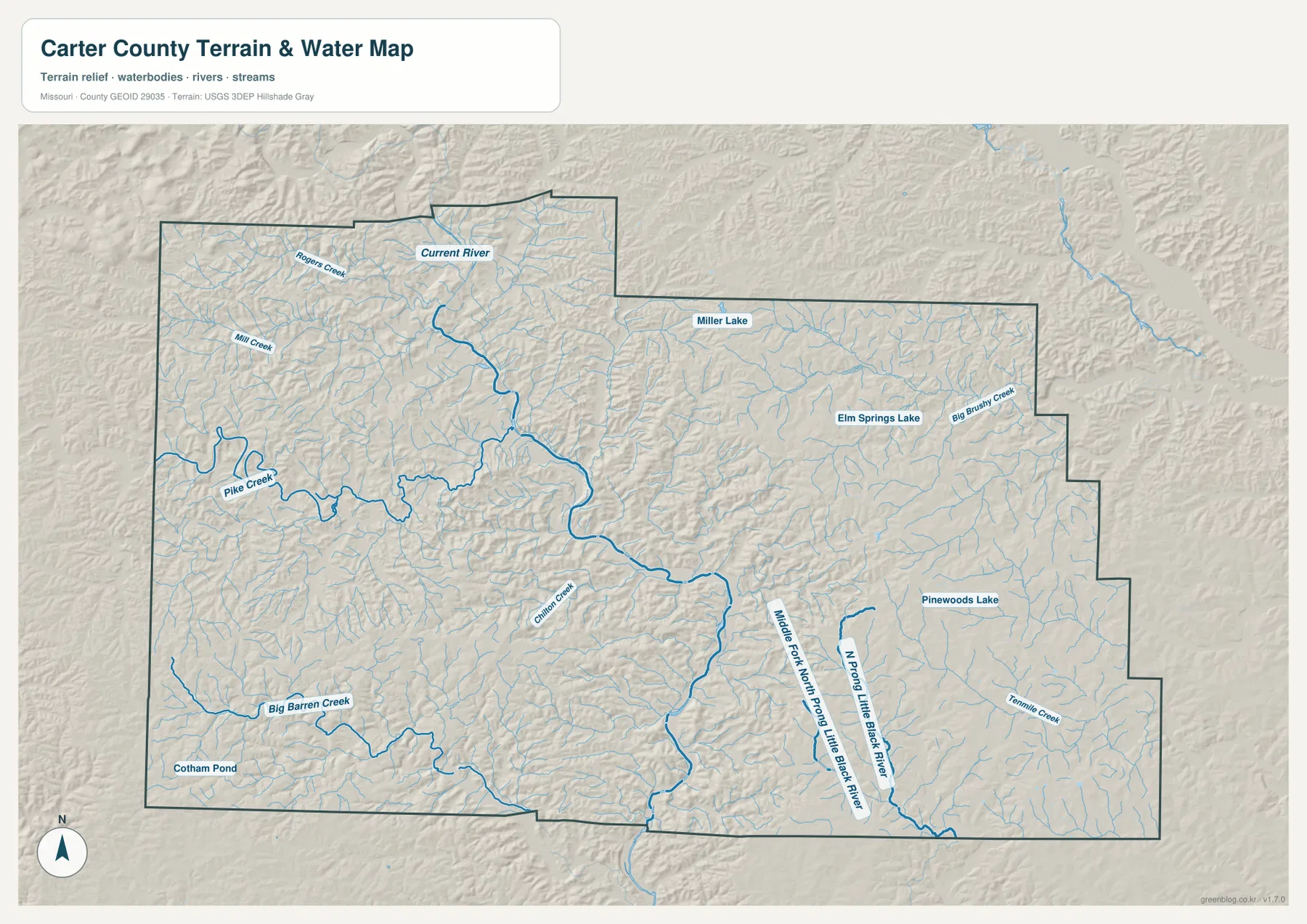
This map works best for understanding physical geography rather than for choosing a launch site or evaluating a flood hazard. It shows how Van Buren relates to the Current River, how tributaries spread into the western uplands, and how the southeast drains along a different set of valleys. Anyone planning river recreation, monitoring high water, or making a property decision should use current NPS, USGS, FEMA, and local information in addition to this static reference map.
A 294-Meter Elevation Range Creates Tight Ridges and Deep Valleys
The elevation map shows why Carter County roads and streams look so winding. The legend reports an actual elevation range of about 116 to 410 meters and a mean near 221 meters, a spread of roughly 294 meters within the county. That amount of local relief is enough to create repeated steep-sided valleys, narrow ridges, and pronounced differences between the river bottoms and nearby uplands.
The Current River valley appears as a dark green ribbon through the interior, with yellow and brown ridges rising quickly on both sides. Higher ground is especially noticeable in the west and southwest, where many short tributaries cut the uplands into closely spaced fingers. Around Van Buren, low river terrain and higher ridges occur within a relatively short distance, which helps explain the strong terrain contrast visible on both the water and elevation maps.
The eastern half is not flat even though some areas appear lower or less strongly colored than the west. Around Ellsinore and the southeastern drainage, long narrow ridges alternate with creek valleys, and the Little Black River branches occupy lower paths through the terrain. The most important pattern is not a simple west-to-east slope; it is the repeated sequence of high ridges separated by narrow stream corridors across much of the county.
The colors are locally scaled to make differences inside Carter County easy to see. Brown does not mean alpine terrain, and green does not mean wetland or an official flood zone. The map is suitable for comparing relative ridges and valleys, but surveying, engineering, drainage design, construction, and parcel-level elevation decisions require more precise USGS data or professional field measurements.
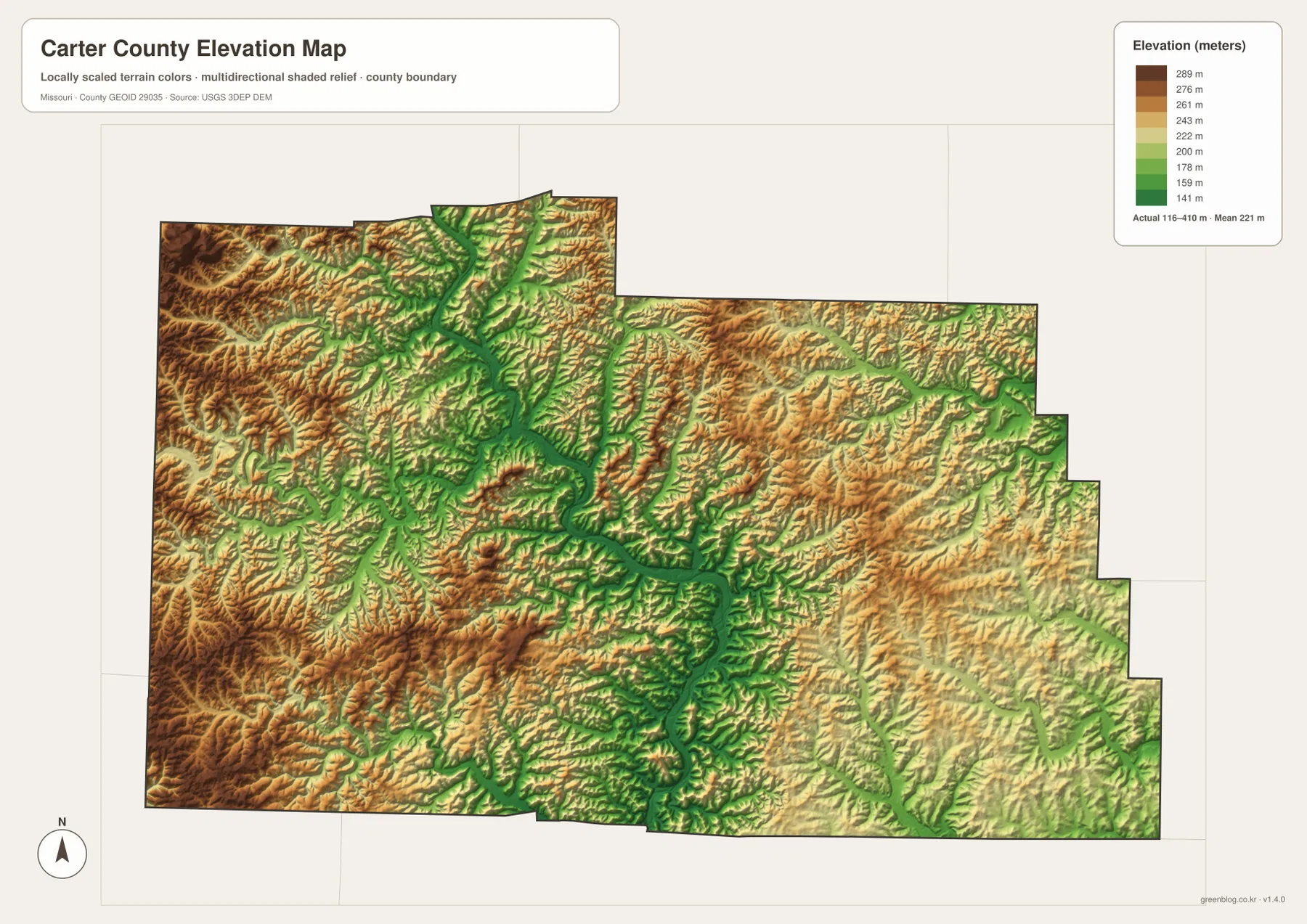
Comparing the city and elevation maps also explains why straight-line distance has limited travel value here. Ellsinore and Grandin are not extremely far from Van Buren as the crow flies, yet intervening ridges and valleys can force roads to take indirect paths. The relief map therefore adds an important layer of context to what otherwise looks like a simple three-point city diagram.
Choosing the Right Carter County Map for Roads, Water, or Relief
Choose the general county map when roads and place names matter most. It combines Van Buren, Ellsinore, Grandin, Hunter, and Fremont with major route numbers and the county outline, so it is the quickest way to establish orientation. It is also the better option when you need to explain how U.S. 60 on the eastern side relates to Route 103 and the Current River setting around Van Buren.
Use the city-connection map when the goal is simply to compare Van Buren, Ellsinore, and Grandin. Its 15-mile and 16-mile labels are direct distances, which makes the map useful for relative placement but not for travel-time estimates. The cleaner design is especially effective in a presentation or worksheet where the full local-road network would add unnecessary detail.
For physical geography, the water and elevation maps work best together. The terrain-and-water version names the Current River, several creeks, Little Black River branches, lakes, and ponds, while the elevation map simplifies the same land into high and low color bands. Looking at both makes it easy to see that the major watercourses occupy deep low corridors and that the surrounding Ozark ridges are closely spaced.
The downloadable originals are 3638 by 2572 pixels each, providing more room to enlarge road numbers, settlement labels, stream names, and subtle shaded relief than the WebP versions embedded in the article. They are useful for general reference, classroom material, and print preparation. They should not be treated as substitutes for current products covering property ownership, legal boundaries, flood insurance, real-time road conditions, navigation, surveying, or engineering.
A concise way to understand Carter County is to connect four observations: Van Buren is the main western reference, the Current River cuts a deep corridor through rugged terrain, Ellsinore connects the county to the U.S. 60 side, and the southeast drains through branches of the Little Black River. Once those features are located, the roads, communities, waterways, and elevation colors stop looking like separate layers and begin to describe one coherent Ozark county landscape.
Frequently Asked Questions
Why is Van Buren the best starting point for reading these Carter County maps?
Van Buren is a major community near the Current River and Route 103, and National Park Service information uses it as a principal access point for the lower Current River district and Big Spring. Starting there makes it easy to compare the locations of Ellsinore, Grandin, and the main river valley before moving to the more detailed terrain and elevation maps.
Are the 15-mile and 16-mile labels on the city map driving distances?
No. The map identifies them as direct distances from Van Buren: about 15 miles to Ellsinore and 16 miles to Grandin. They are straight-line measurements. Because Carter County has many ridges, valleys, and winding roads, actual road mileage and travel time can be noticeably different.
Does green on the elevation map mean an official flood zone?
No. Green marks relatively lower elevation within the locally scaled Carter County terrain image, including the Current River and tributary valleys. Official flood risk depends on river stage, rainfall, drainage, mapped floodplains, and other factors. Use current FEMA, USGS, National Park Service, and local information for safety, insurance, or property decisions.
Map File Information
The ZIP contains the original high-resolution JPG files for the county map, city-connection map, terrain-and-water map, and elevation map shown in this article. The originals are larger than the on-page WebP images and make road numbers, stream labels, and terrain detail easier to inspect.
- Included Files: 4 maps
- File Type: JPG
Related Maps
Sources and References
- National Park Service – Ozark National Scenic Riverways Basic Information: official information confirming the park’s presence in Carter County and the Big Spring Entrance Station south of Van Buren.
- National Park Service – Ozark National Scenic Riverways Park Brochure: regional map and access context for Van Buren, the Current River, U.S. 60, and park facilities.
- U.S. Census Bureau TIGER/Line Shapefiles: official county-boundary and transportation geography.
- USGS National Hydrography: official river, stream, lake, and related hydrography data.
- USGS 3D Elevation Program: official elevation and terrain-surface data.
Green Map creates custom-edited map images using open geographic data sources such as geoBoundaries, Natural Earth, OpenStreetMap, and government open data. These maps are edited visual materials, not raw data files, and are provided for education, documents, presentations, and graphic reference.