Arenac County sits on the lower side of Saginaw Bay in Michigan’s Lower Peninsula, where a broad low shoreline meets higher inland country to the west. Standish anchors the southwestern road network, Omer and Au Gres lie farther east, and Twining and Turner occupy the north-central part of the county. The Rifle, Au Gres, and Pine rivers cross different parts of the landscape on their way toward the bay, so roads, water, and relief tell a connected geographic story.
This page separates that information into useful views for roads and places, six highlighted communities, rivers and lakes, and elevation. High-resolution JPG originals are also available in the ZIP download, making the maps useful for printing, classroom handouts, presentations, or detailed regional reference. A simple way to begin is to locate Standish and Au Gres, then compare the roads, river valleys, and changes in elevation between the western interior and the bay shore.
The county outline is not a simple rectangle. Its western interior broadens around the Rifle River country, the southern boundary drops around the Standish area, and the eastern edge follows the irregular shoreline of Saginaw Bay. Many smaller streams start in or near the higher western ground and descend toward flatter central and eastern areas. That relationship becomes especially clear when the terrain-and-water map is viewed beside the elevation map.
Table of Contents
Roads linking Standish, Omer, Au Gres, and the northern communities
Standish is the easiest road reference on the general county map. I-75, US-23, and M-13 pass close to the southwestern part of the county, while M-61 approaches from the west and other local roads spread toward Sterling and Omer. M-33 runs along the western side, providing another north-south reference for the inland portion of Arenac County. The concentration of numbered highways around Standish contrasts with the more widely spaced roads near the bay shore.
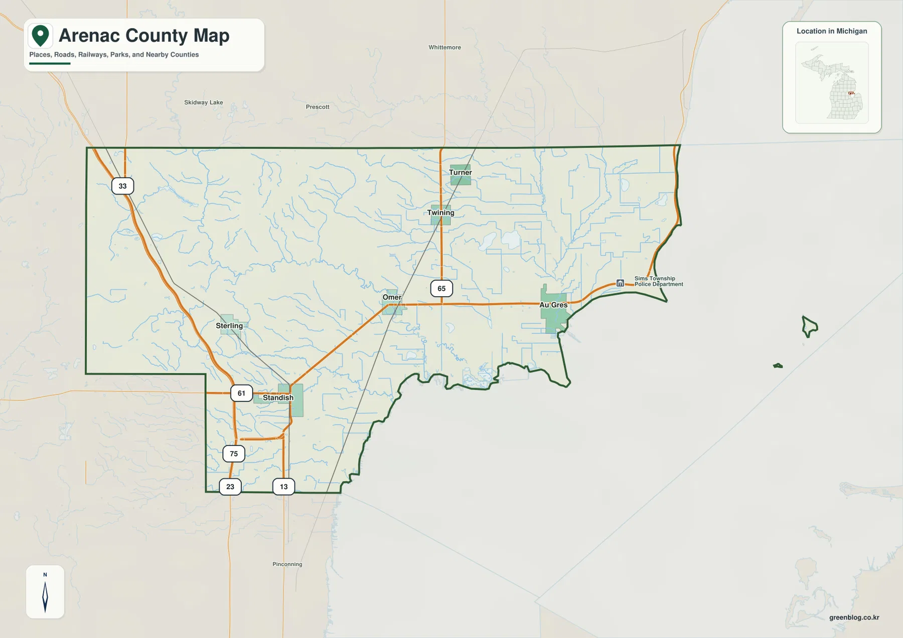
East of Standish, the main road pattern leads toward Omer and then Au Gres. Omer sits close to the Rifle River, while Au Gres is much nearer the bay and the Au Gres River. M-65 crosses the county from north to south through Turner and Twining before meeting the central east-west route, making it a useful reference for travel between the northern communities and the Omer–Au Gres corridor.
Sterling lies northwest of Standish in a part of the county where the Rifle River and its tributaries occupy a more strongly rolling landscape. The roads there do not have the same open, lowland setting seen east of Omer. Looking at the general map together with the elevation view helps explain why western routes often cross or follow stream valleys before reaching the flatter central portion of the county.
Twining and Turner sit close together in the north-central area, with Turner nearer the northern county line. M-65 passes through this pair and continues south, creating a clear geographic link with the central part of Arenac County. Au Gres, by comparison, is positioned far to the east near the coast, so the northern interior and the bay-side community depend on different parts of the county road system.
Several labels outside the green county boundary, including Prescott, Whittemore, and Pinconning, are shown only as surrounding reference points. They should not be confused with places inside Arenac County. The key internal labels on this map are Standish, Sterling, Omer, Au Gres, Twining, and Turner, along with the numbered highways that connect them.
Six highlighted communities spread from the western interior to the bay
The city-distribution map removes much of the road detail and numbers six highlighted places. Standish is number 1 in the southwest, Au Gres is number 2 in the east, Sterling is number 3 farther west, Omer is number 4 near the center, Twining is number 5 in the north-central area, and Turner is number 6 just above it. The arrangement makes the county’s dispersed settlement pattern easier to see without the distraction of highway labels.
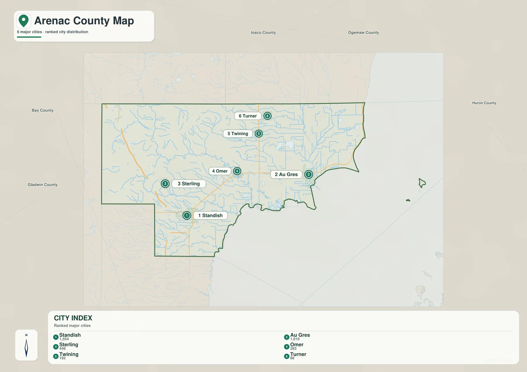
The CITY INDEX printed on the map lists reference values of 1,554 for Standish, 1,018 for Au Gres, 448 for Sterling, 283 for Omer, 192 for Twining, and 86 for Turner. These figures are best treated as the ranking data used in the graphic, not as a guarantee of the latest official population. Current population estimates should be checked against the relevant U.S. Census Bureau release or local government source.
Standish and Sterling appear relatively close on the southwest and western sides, but their settings are quite different. Standish is near the county’s strongest concentration of major highways, while Sterling is closer to the higher western terrain and the Rifle River tributary network. The distance between two dots therefore tells only part of the story; the general road map and elevation map add the context that the simplified place view intentionally leaves out.
Omer and Au Gres form a central-to-eastern pair. Omer is inland near the Rifle River, while Au Gres is associated more closely with the Au Gres River and the bay shoreline. On this simplified map the two points look like a straightforward east-west sequence, but the water view reveals the broad lowlands and branching streams that separate their immediate surroundings.
Twining and Turner make the northern pattern easy to recognize. They are aligned closely along the same general north-south corridor, with Turner nearer the county line. This graphic is not intended to show every community or unincorporated place in Arenac County; its purpose is to compare the relative positions of the six selected settlements quickly and clearly.
Rifle, Au Gres, and Pine rivers descending toward Saginaw Bay
The terrain-and-water map shows a strong west-to-east and west-to-southeast drainage pattern. The Rifle River enters the central part of the county from higher western ground and bends toward the lower interior. The Au Gres River occupies the eastern lowlands near the bay, while the Pine River and North Branch Pine River cross the southern part of the county. Numerous smaller streams feed these larger channels from the rolling uplands.
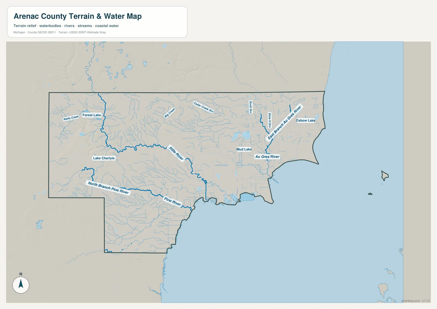
The Rifle River is the most prominent inland river on the western half of the map. Forest Lake and Lake Charlye appear nearby, and smaller labeled features such as Wells Creek and Big Creek add detail to the tributary network. The main river curves through lower ground cut into the western hills, so its route is easier to understand when the water map is compared with the shaded elevation colors.
Farther east, the Au Gres River occupies a flatter landscape. Mud Lake lies near the central-eastern lowlands, Oxbow Lake appears to the northeast, and East Branch Au Gres River descends from the north before joining the larger drainage. The river system is therefore more complex than a single channel running straight to the bay, with several tributaries and low wet areas shaping the approach to the coast.
The southern part of the county contains another distinct river system. North Branch Pine River crosses the southwest before meeting the broader Pine River network, and the main river continues toward the Saginaw Bay side of the county. Small tributaries are dense in this area, particularly where the western interior begins to slope down toward the lower coastal plain.
This map is designed for geographic reference rather than flood planning, navigation, fishing regulation, or water-quality assessment. It does not provide water depth, access rights, hazard zones, or current conditions. Those uses require current Michigan and federal sources. Here, the water view is most useful for seeing which rivers occupy the western hills, central valleys, southern lowlands, and bay-side areas.
Higher western ridges give way to low Saginaw Bay terrain
The elevation map makes Arenac County’s broad relief pattern immediately visible. Its legend reports an actual range of roughly 176 to 262 meters with a mean of 205 meters. Greens represent the lower parts of the county, while yellow, orange, and brown identify progressively higher ground. Most of the eastern half is green, whereas the west and northwest contain the strongest concentrations of higher terrain.
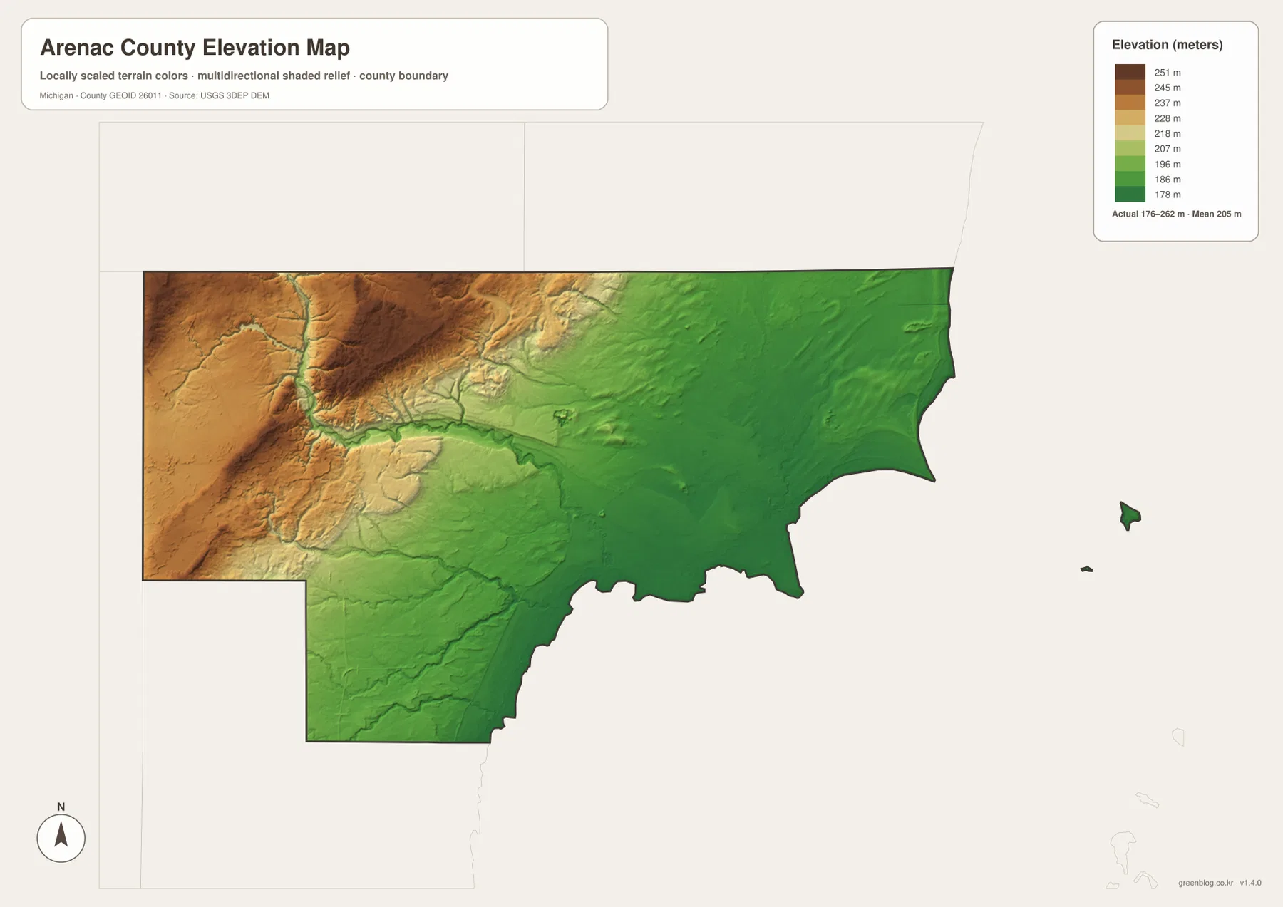
The highest colors are concentrated along the western and northwestern interior. Green valleys cut through the brown and orange ridges, and several of those lower corridors correspond closely with the Rifle River and its tributaries. The area is therefore not one flat block of upland; it consists of higher rolling ground divided by river valleys that descend toward the center of the county.
Moving east, the map shifts gradually toward lighter greens and then broader dark-green lowlands. The Omer–Au Gres side of the county appears flatter and lower than the country west of Sterling. Near Saginaw Bay, the relief becomes subdued, which matches the terrain-and-water map where the Au Gres River, smaller streams, and coastal lowlands occupy the eastern portion.
Standish sits near the transition between those environments. Ground rises toward the northwest and west, while the south and east trend toward the lower coastal plain. When the elevation map is paired with the road map, the concentration of major transportation routes near Standish can be viewed within this broader transition zone rather than as an isolated highway junction.
The elevation image is a county-scale reference, not survey-grade data for a specific property. Engineering slopes, drainage design, construction, and precise site elevations require the underlying USGS 3D Elevation Program data or another authoritative detailed source. For this page, the map is best used to compare the higher western interior with the lower central and eastern parts of Arenac County.
Reading the road, community, river, and elevation views together
Standish shows why the map set works best as a group. The general map emphasizes highways converging near the southwest, and the community map places Standish relative to the other five highlighted settlements. The elevation view shows it near the transition from western uplands to lower eastern terrain, while the water map adds the Rifle and Pine river systems around the broader southern area.
Au Gres has a different combination of features. It is positioned at the eastern end of the central road corridor, near the Au Gres River and close to Saginaw Bay. The elevation map places the community in a broad lowland, so the road, water, and relief views all point toward a coastal setting that differs from Sterling or the western interior.
Sterling is especially useful for understanding the county’s higher side. It lies west of Standish and north of the strongest southwest road junctions, near a part of the Rifle River tributary network that cuts through higher terrain. Following the maps eastward from Sterling toward Omer reveals a general decline in elevation as the river valley opens toward the central lowlands.
Twining and Turner provide another comparison. Their north-central locations line up closely with M-65, and their surrounding landscape contains many small streams and low drainage channels. The simplified place map makes the north-south relationship obvious, while the terrain map supplies the water detail and the elevation map shows that the northern interior still contains subtle changes in relief.
No single view is meant to replace the others. Use the general map for roads and place names, the distribution map for quick comparisons among the six highlighted communities, the water map for rivers and lakes, and the elevation map for higher and lower terrain. Switching among them allows a reader to answer a location question without forcing every type of information into one crowded image.
Choosing an Arenac County map and using the high-resolution files
The general county map is the best starting point when the main task is finding Standish, Sterling, Omer, Au Gres, Twining, Turner, or the numbered highways. It works well for regional orientation and planning a broad route, but it does not show live traffic, closures, or construction. Current driving decisions should always be checked with up-to-date transportation or navigation services.
For a presentation that only needs the relative positions of the six highlighted communities, the distribution map is cleaner. The terrain-and-water map is more useful for the Rifle, Au Gres, and Pine rivers and their relation to the bay. Choose the elevation map when the subject is the contrast between the western ridges, river valleys, and the lower coastal plain.
The WebP images on this page are optimized for quick browser viewing. The ZIP below contains the original high-resolution JPG files for the general county map, community distribution map, terrain-and-water map, and elevation map. Those larger files are the better option for printing, classroom materials, presentations, and large-screen viewing where extra image detail is useful.
Frequently Asked Questions
Which map is best for finding Standish, Au Gres, and the main highways?
Use the general county map. It shows the major road concentration around Standish, the route east through Omer toward Au Gres, and M-65 running through Twining and Turner. For live driving times, closures, construction, or traffic conditions, use a current navigation or transportation source as well.
Which map best compares the Rifle, Au Gres, and Pine rivers?
The terrain-and-water map is the best choice. It shows the Rifle River crossing the western and central interior, the Au Gres River in the eastern lowlands, and the Pine River system in the south. It is a location reference rather than a flood, navigation, fishing, or water-quality map.
Where is Arenac County highest on the elevation map?
The western and northwestern interior contains the highest colors, while the broad eastern side near Saginaw Bay is much lower. The map legend reports an actual range of about 176 to 262 meters, but exact site elevations should be checked in authoritative elevation data.
Map File Information
The ZIP contains high-resolution JPG originals covering Arenac County roads and places, highlighted communities, rivers and lakes, and elevation.
- Included Files: general county map, community distribution map, terrain-and-water map, elevation map
- File Type: JPG
Related Maps
Sources and reference links
For county government and local background, visit the official Arenac County website. For the underlying types of boundary, hydrography, and elevation information used in county mapping, consult U.S. Census Bureau TIGER/Line, USGS National Hydrography, and the USGS 3D Elevation Program. These page maps are general reference products and do not replace legal boundaries, survey data, navigation charts, or flood determinations.
Green Map creates custom-edited map images using open geographic data sources such as geoBoundaries, Natural Earth, OpenStreetMap, and government open data. These maps are edited visual materials, not raw data files, and are provided for education, documents, presentations, and graphic reference.