Baraga County in Michigan’s western Upper Peninsula combines a Lake Superior shoreline with a broad forested interior and a large rise in elevation toward the south and east. Baraga and L’Anse sit close together near the northern coast, while Pelkie, Zeba, Skanee, Covington, and Three Lakes spread across very different parts of the county. The irregular shoreline and much larger inland section make the county easier to understand when roads, settlements, water, and elevation are viewed separately and then compared.
This page provides a road-and-place map, a simplified view of the two highlighted population centers, a terrain-and-water map, and an elevation map. High-resolution JPG originals of the supplied maps are also available in a single ZIP download for printing, classroom use, presentations, and detailed regional reference. The maps share the same county boundary but answer different questions, so readers can move from roads to rivers or from settlement locations to terrain without forcing every detail into one image.
The overall map places Baraga and L’Anse near the north-central shoreline, with Pelkie to the west, Zeba to the east, and Skanee farther northeast. Covington and Three Lakes provide southern reference points along the inland road network. US-41 and M-28 are important orientation routes, while the elevation map shows that the low Lake Superior side gives way to much higher terrain across the interior.
Table of Contents
US-41 connects the Baraga–L’Anse area with the broad inland county
The general county map makes Baraga and L’Anse the clearest starting points. They sit close to the Lake Superior shoreline and are linked by US-41, which continues south through the county. Pelkie lies farther west, while Zeba and Skanee give useful reference points along the northern and northeastern side. Their positions show how the populated shoreline area occupies only a small part of Baraga County’s full extent.
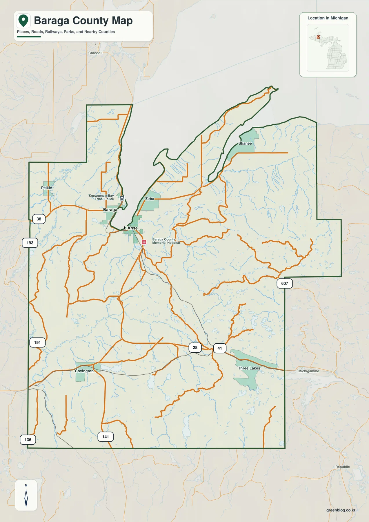
On the western side, M-38 is a useful reference near Pelkie and the roads approaching the county from the west. Farther south, the route pattern opens across a much larger interior. Around Covington, US-41 and M-28 become major east-west and north-south references, and US-141 reaches the southwestern part of the mapped area. The contrast between the narrow northern shoreline section and the broad southern interior is especially clear here.
US-41 is the most direct visual link between L’Anse and the southern part of the county. As the road moves away from the coast, the map shows fewer named communities and many more small streams and lakes. Covington and Three Lakes help anchor the southern half, while M-28 provides a strong east-west route through the interior. The road network therefore changes from a compact coastal pattern to longer rural connections.
The northeastern area around Skanee is part of the same Lake Superior side of the county but sits well away from Baraga and L’Anse. The county boundary follows a long projection along the coast, so straight-line distance can be misleading. Zeba is much closer to the central shoreline communities, while Skanee sits farther out along the northeastern section. The road map is the better tool for understanding these practical connections.
The map also marks local facilities such as Baraga County Memorial Hospital and Keweenaw Bay Tribal Police, giving additional orientation around the Baraga–L’Anse area. These labels help establish where community services are concentrated, but the image is not a live transportation product. Current road conditions, winter closures, construction, and travel times should be checked with up-to-date transportation or navigation sources.
Baraga and L’Anse form a close pair on the northern side
The highlighted-place map strips away most road detail and focuses on only two locations. Baraga is marked as number 1 and L’Anse as number 2, and the markers sit very close together near the north-central part of the county. Against the county’s large inland area, their compact spacing is the main geographic message of the map.
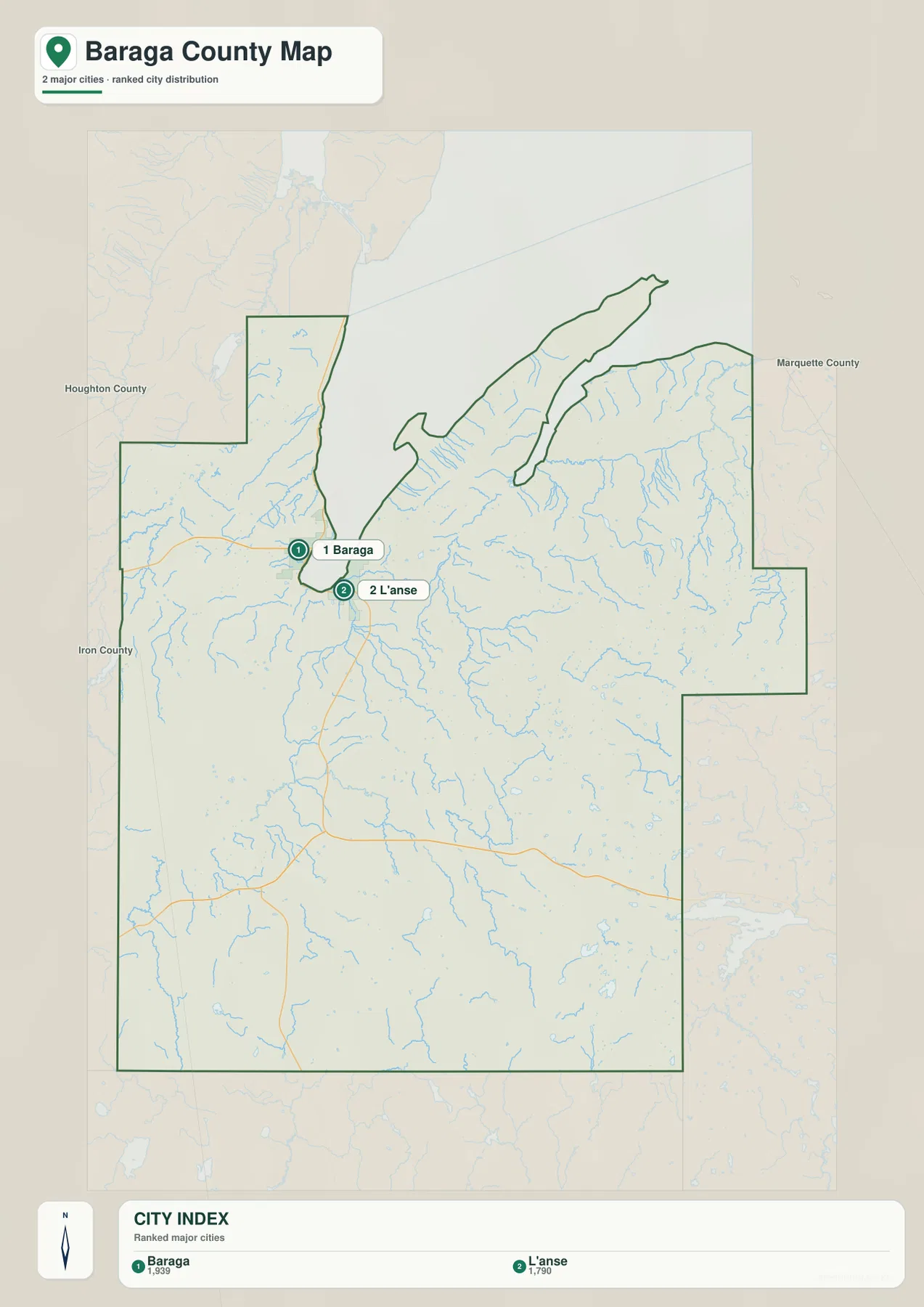
The CITY INDEX printed at the bottom lists reference values of 1,939 for Baraga and 1,790 for L’Anse. These figures are best treated as ranking values used for the map rather than a claim about the latest official population. Readers who need current estimates should consult the appropriate U.S. Census Bureau release for the relevant year and geography.
The general map explains the close pairing more clearly. Baraga sits near the western side of the inner bay area, while L’Anse is positioned to the southeast, and US-41 links the two. Other named communities are much more dispersed: Pelkie is to the west, Skanee far to the northeast, and Covington well to the south. The two highlighted places therefore represent a compact northern center within a very large county.
This simplified view is not intended to inventory every settlement. Zeba, Skanee, Pelkie, Covington, Three Lakes, and other named places remain important geographic references but are not part of the two-point index. Use the general county map when those communities or road connections matter, and use the highlighted-place map when the only question is where Baraga and L’Anse sit relative to the county boundary.
Much of southern Baraga County looks empty on this map because the purpose is to emphasize the two ranked places, not because the interior lacks geographic features. The water and elevation maps reveal a dense network of rivers, lakes, valleys, and higher uplands across that same area. Combining the views prevents the simplified place map from being mistaken for a complete picture of the county.
Silver, Sturgeon, Huron, and other rivers cut through a lake-filled interior
The terrain-and-water map shifts attention from roads to Lake Superior, rivers, streams, and inland lakes. Silver River and Sturgeon River run through the central part of the county, while the eastern side includes Ravine River, Slate River, and West Branch Huron River. Falls River appears farther west, and Perch River and West Branch Net River are labeled in the southwestern interior.
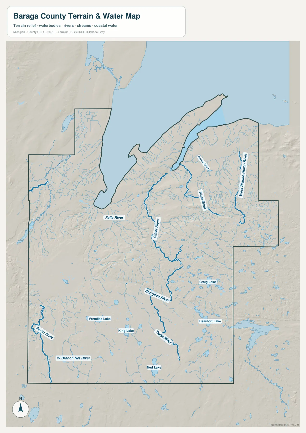
Silver River occupies a north-central corridor, while Sturgeon River extends much farther into the interior and is joined by smaller tributaries. Tioga River is labeled farther south along the broader drainage area. None of these waterways follows a perfectly straight course; they bend through low valleys between ridges. That relationship becomes clearer when the water map is compared directly with the elevation view.
Eastern Baraga County has a particularly dense stream pattern. Slate River and West Branch Huron River stand out as thicker blue lines, while Ravine River lies nearer the northeastern shoreline. Many smaller tributaries branch across the surrounding uplands. This part of the map looks more dissected than the western side, suggesting repeated valleys and ridges rather than one broad flat plain.
Several named lakes appear across the south: Vermilac Lake, King Lake, Craig Lake, Beaufort Lake, and Ned Lake are all visible. They are scattered rather than arranged as one long connected lake chain. On a road map these smaller water bodies can be easy to overlook, but in the water view they help show how extensively water is distributed through the forested interior.
This map is a geographic reference for the location of rivers, streams, lakes, and coastal water. It does not provide flood zones, depth, current speed, water quality, navigability, boating rules, or public-access rights. Fishing, boating, flood planning, and other regulated activities should use current Michigan and federal information in addition to this general county-scale view.
Low Lake Superior terrain rises sharply toward the southern and eastern uplands
The elevation map removes most labels and uses a locally scaled color ramp with shaded relief. Its legend reports an actual elevation range of about 183 to 602 meters and a mean of 409 meters. Dark green represents the lower portions of Baraga County, lighter greens and yellows show intermediate elevations, and brown identifies the higher uplands. Because the color scale is local, identical colors on another county map should not be treated as the same elevation.
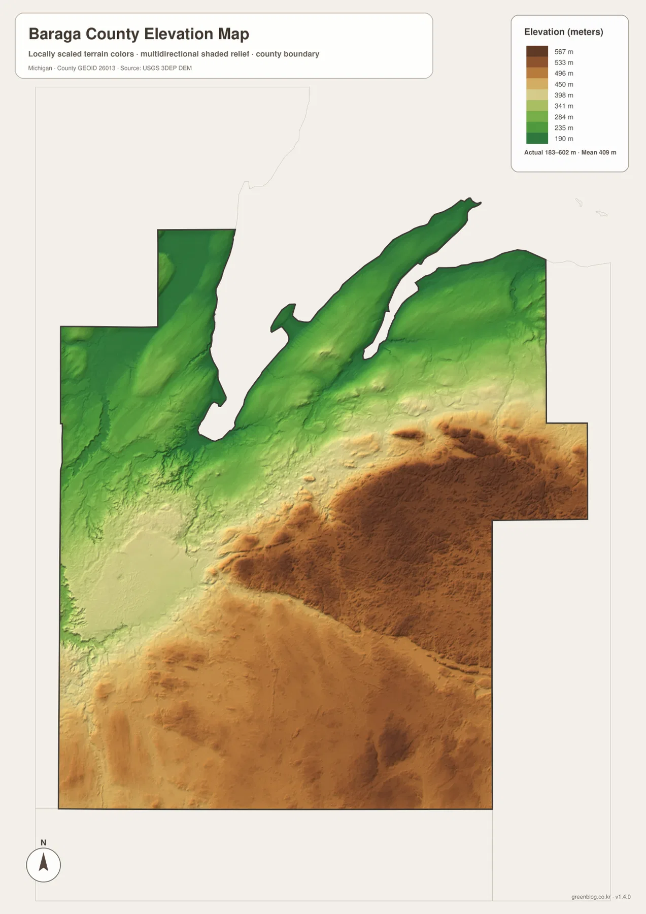
The darkest green terrain follows much of the Lake Superior side and the Baraga–L’Anse area. Lower valleys extend inland from the coast, matching several of the river corridors visible on the water map. The northwestern section also contains broad low areas, which makes the shoreline side of the county look very different from the high ground farther south and east.
Colors become progressively warmer toward the interior. Large yellow, orange, and brown areas dominate the central-southern and eastern portions, with the strongest high-elevation colors across the east-central and southeastern terrain. Heavy relief shading reveals repeated ridges and valleys rather than a smooth plateau. The result is one of the strongest shoreline-to-interior elevation contrasts among the county’s four views.
Comparing the elevation map with the Sturgeon, Slate, and Huron river systems helps explain the lower channels that cut into the uplands. Green and light-green strips often follow drainage corridors through surrounding brown terrain. These lower paths are not all at the same absolute height, but they make the relationship between topography and water much easier to see.
The southwestern interior is also much higher than the coast, though its colors are generally more mixed than the darkest eastern highlands. Broad yellow-brown terrain contains lower stream valleys and many small depressions around lakes. The county therefore does not simply rise in one uniform slope; it gains elevation inland while retaining a complicated network of lower drainage routes.
This elevation surface is a generalized county-scale reference, not survey-grade measurement. Exact parcel elevations, engineering slopes, drainage design, construction planning, or other precise work should use authoritative detailed data such as the USGS 3D Elevation Program rather than estimating values from the colors on this image.
What changes when roads, settlements, water, and relief are compared
Baraga and L’Anse illustrate how the four map types reinforce one another. The general map shows US-41 and surrounding roads, while the highlighted-place map makes their close spacing obvious. The water view places them beside the Lake Superior side of the county, and the elevation map confirms that the coastal area is much lower than the interior uplands.
Covington and Three Lakes tell a different story. On the road map they are useful southern reference points along US-41 and M-28, far from the compact Baraga–L’Anse pair. The water map shows scattered lakes and streams around the southern interior, and the elevation view places much of that territory on higher yellow-brown ground instead of the dark-green coastal lowlands.
The northeastern area around Skanee becomes more understandable when the maps are combined. The road map provides the place and access context, the water map shows Ravine River, Slate River, West Branch Huron River, and many smaller tributaries, and the elevation map reveals those waterways cutting through terrain that rises strongly inland from the coast.
For the named southern lakes, the water map is the fastest starting point. Vermilac, King, Craig, Beaufort, and Ned lakes can be compared in one view, after which the general map can be used to relate them to Covington, Three Lakes, and the main road system. The elevation map adds a third layer by showing the higher terrain surrounding many of those inland water bodies.
Each map therefore has a distinct job. The general map is best for roads and named places, the highlighted-place map for the close Baraga–L’Anse relationship, the water map for rivers and lakes, and the elevation map for the strong contrast between the low Lake Superior side and the higher inland country. Together they provide a fuller picture without overloading a single image.
Choosing a Baraga County map and using the downloadable files
Start with the general county map when roads and place names matter. It brings Baraga, L’Anse, Pelkie, Zeba, Skanee, Covington, Three Lakes, US-41, M-28, M-38, and US-141 into one frame. It works well for regional orientation, but current travel times, snow conditions, construction, and road closures should always come from live transportation or navigation sources.
Use the highlighted-place map when the goal is simply to show where Baraga and L’Anse sit within the county. Choose the terrain-and-water map for the Sturgeon, Silver, Slate, and Huron river systems and the scattered inland lakes. Choose the elevation map when the main question is how quickly the low Lake Superior side gives way to the higher southern and eastern interior.
The WebP images on this page are optimized for quick browser viewing. The ZIP below contains the original high-resolution JPG versions of the general county map, highlighted-place map, terrain-and-water map, and elevation map. Those originals are a better choice for printing, large screens, classroom handouts, and presentations where additional image detail is useful.
Frequently Asked Questions
Which map is best for finding Baraga and L’Anse together?
Use the general county map to see the two communities, US-41, and the surrounding road network. The highlighted-place map is also useful when you only need their relative positions, because it removes most other detail and shows how closely they sit together near the northern shoreline.
Which map shows the Sturgeon, Silver, and Huron river systems?
Use the terrain-and-water map. It labels Sturgeon River, Silver River, Slate River, West Branch Huron River, several other rivers, and a number of inland lakes. It is a location reference and does not provide flood, depth, navigation, water-quality, or access information.
Where does Baraga County appear highest on the elevation map?
The lowest dark-green terrain lies along much of the Lake Superior side and around Baraga and L’Anse. Higher yellow and brown terrain becomes widespread toward the central-southern, eastern, and southeastern interior. The legend reports an actual range of roughly 183 to 602 meters, but exact site elevations should be checked in authoritative elevation data.
Map File Information
The ZIP contains the high-resolution JPG originals for the Baraga County general map, highlighted-place map, terrain-and-water map, and elevation map described on this page.
- Included Files: general county map, highlighted-place map, terrain-and-water map, elevation map
- File Type: JPG
Related Maps
Sources and reference links
For county government and local information, see the official Baraga County website and the Baraga County Convention & Visitors Bureau. For the underlying types of boundary, hydrography, and elevation information used in county mapping, consult U.S. Census Bureau TIGER/Line, USGS National Hydrography, and the USGS 3D Elevation Program. These page maps are general reference products and do not replace legal boundaries, survey data, navigation charts, or flood determinations.
Green Map creates custom-edited map images using open geographic data sources such as geoBoundaries, Natural Earth, OpenStreetMap, and government open data. These maps are edited visual materials, not raw data files, and are provided for education, documents, presentations, and graphic reference.