Towns County sits at the northern edge of Georgia, where Hiawassee, Young Harris, Lake Chatuge, winding mountain roads, and steep ridges define the county at a glance. This page includes four county-specific map views, and you can download all four maps as high-resolution A3 JPG files in one ZIP for printing, presentations, classroom use, or offline reference. The maps separate the county boundary and major roads, city locations, waterways and terrain, and elevation so each subject remains easy to read while still describing the same mountainous county.
The maps are designed as geographic reference material rather than parcel, flood, engineering, or navigation products. Their main value is in showing how Towns County fits together: development and major roads are concentrated toward the northern valleys, Lake Chatuge occupies a prominent position near Hiawassee, streams follow narrow mountain drainage corridors, and the elevation surface rises sharply into ridges around the county. Looking at the four views together makes those relationships much easier to understand than relying on a single boundary map.
Table of Contents
Lake Chatuge and the road network shape the northern half
The general county map immediately draws attention to the north. Hiawassee is labeled close to Lake Chatuge, and Young Harris appears to the west. Much of the southern half contains winding roads and numerous small streams but no comparable cluster of large place labels. The northern edge is also the Georgia state line with North Carolina, so the county should not be read as an isolated mountain basin. Its principal communities sit close to a state boundary and to roads that continue beyond the county.
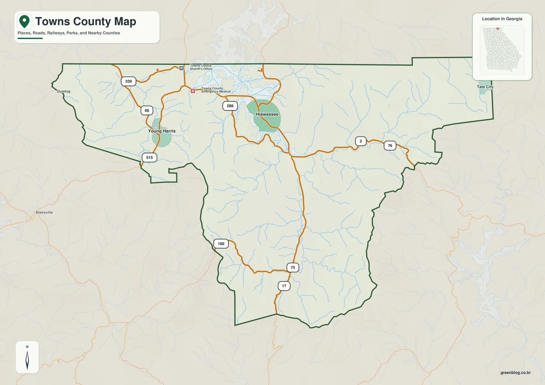
Several numbered routes explain how travel is organized through this steep terrain. Routes 2 and 76 form the most obvious east-west corridor across the northern part of the county. Near Hiawassee, Routes 75 and 17 turn south through the interior, following a much narrower path between ridges. On the Young Harris side, Routes 515, 66, and 339 connect into the western road network, while Route 288 is labeled near Hiawassee. The roads bend repeatedly rather than following a regular grid, which is consistent with the closely spaced valleys visible on the terrain maps.
The map also marks the Towns County Sheriff’s Office and an emergency medical facility north of Hiawassee. Those symbols are useful because they reinforce where the county’s main service center is located, but the map is intentionally selective. It does not attempt to show every neighborhood street, forest road, driveway, unincorporated community, or property line. For a quick county-wide orientation, that simplification keeps the strongest geographic relationships readable.
Hiawassee and Young Harris form a tight northern city pattern
The city-distribution view strips away much of the extra detail and makes one fact especially clear: the two highlighted cities are both in the northern part of Towns County. Hiawassee is the eastern of the pair and sits beside the Lake Chatuge area, while Young Harris is west of it. The large mountainous southern interior has no separate major-city marker on this view. That contrast is useful when explaining why a small county can have a large amount of land that feels rural and mountainous even though its two incorporated centers are relatively close to one another.
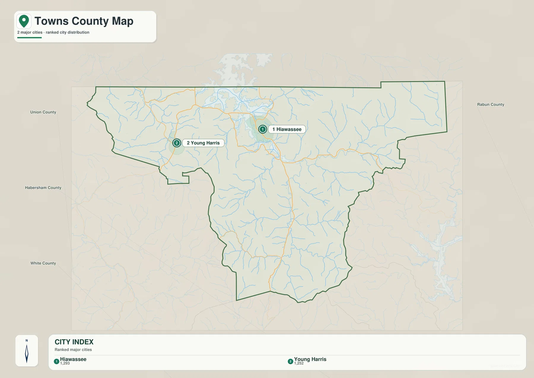
Neighboring county labels provide another useful frame of reference. Union County appears to the west, Rabun County to the east, and White and Habersham counties are shown to the southwest and south. Together with the North Carolina line along the top of the county, these labels make it easier to place Towns County within the far north of Georgia without needing a separate statewide map. Young Harris is closer to the western side, while Hiawassee is more central to the lake and the east-west road corridor.
This city map is best for comparing settlement positions, not estimating driving time. Mountain roads often curve around slopes, streams, and lake shorelines, so two places that appear close in a straight geographic view may require a less direct road route. When route planning matters, the city view works better as an orientation layer used alongside the general county map rather than as a substitute for a current road-navigation service.
Lake Chatuge connects a dense network of mountain waterways
The terrain-and-water map gives Lake Chatuge much more visual weight than the general reference map. The lake occupies the north-central part of the mapped area and continues beyond the county line. The Hiwassee River is the principal named river associated with the lake, while many shorter creeks enter from the surrounding mountain valleys. Because the water features do not stop at an administrative boundary, this view is especially helpful for separating the physical landscape from the county outline.
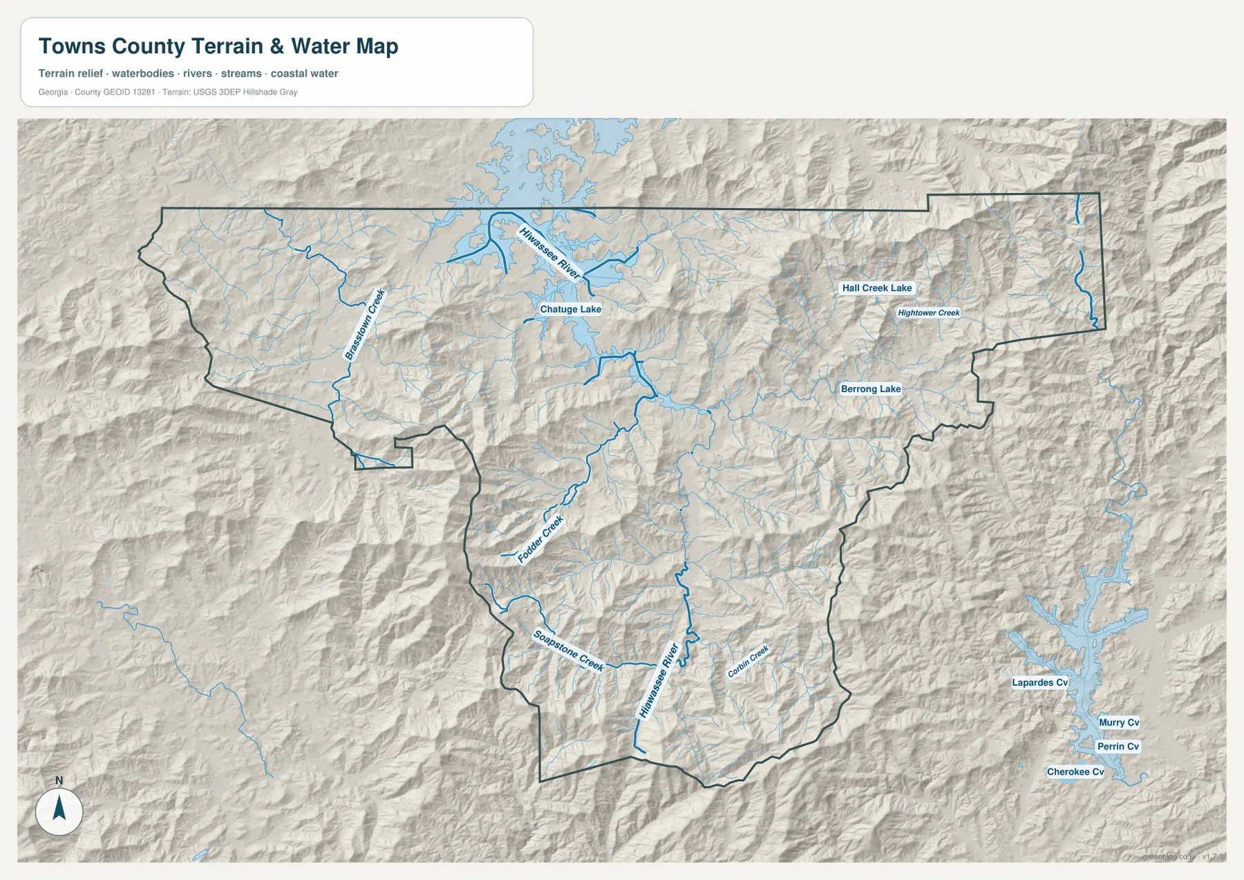
Several named tributaries help show how widespread the drainage network is. Brasstown Creek is labeled on the western side, while Fodder Creek and Soapstone Creek appear farther south and southwest. Hightower Creek is labeled in the eastern part of the county, and the map also identifies Hall Creek Lake and Berrong Lake. Beyond those named features, many fine blue lines branch through narrow valleys. The pattern is not one broad river plain; it is a collection of short mountain drainage routes separated by ridges.
The shaded relief makes that relationship easy to see. Streams occupy lower corridors between repeated folds of higher ground, and the larger lake sits in a broader low area near the northern communities. This helps explain why roads frequently share valley space with creeks and why road directions change so often across a relatively small county. The map is not intended to show flood zones, navigable channels, water depth, access rights, or safe boating routes. Those questions require specialized and current official information.
Elevation rises from valley floors to ridges above 1,400 meters
The elevation view is the strongest evidence of how rugged Towns County is. The map reports an actual elevation range of about 519 to 1,455 meters, with a mean of roughly 777 meters. That is a substantial vertical difference within one county. Lower elevations are concentrated in the broader valleys and around the Lake Chatuge area, while higher terrain forms long ridges along the margins and through the mountainous interior.
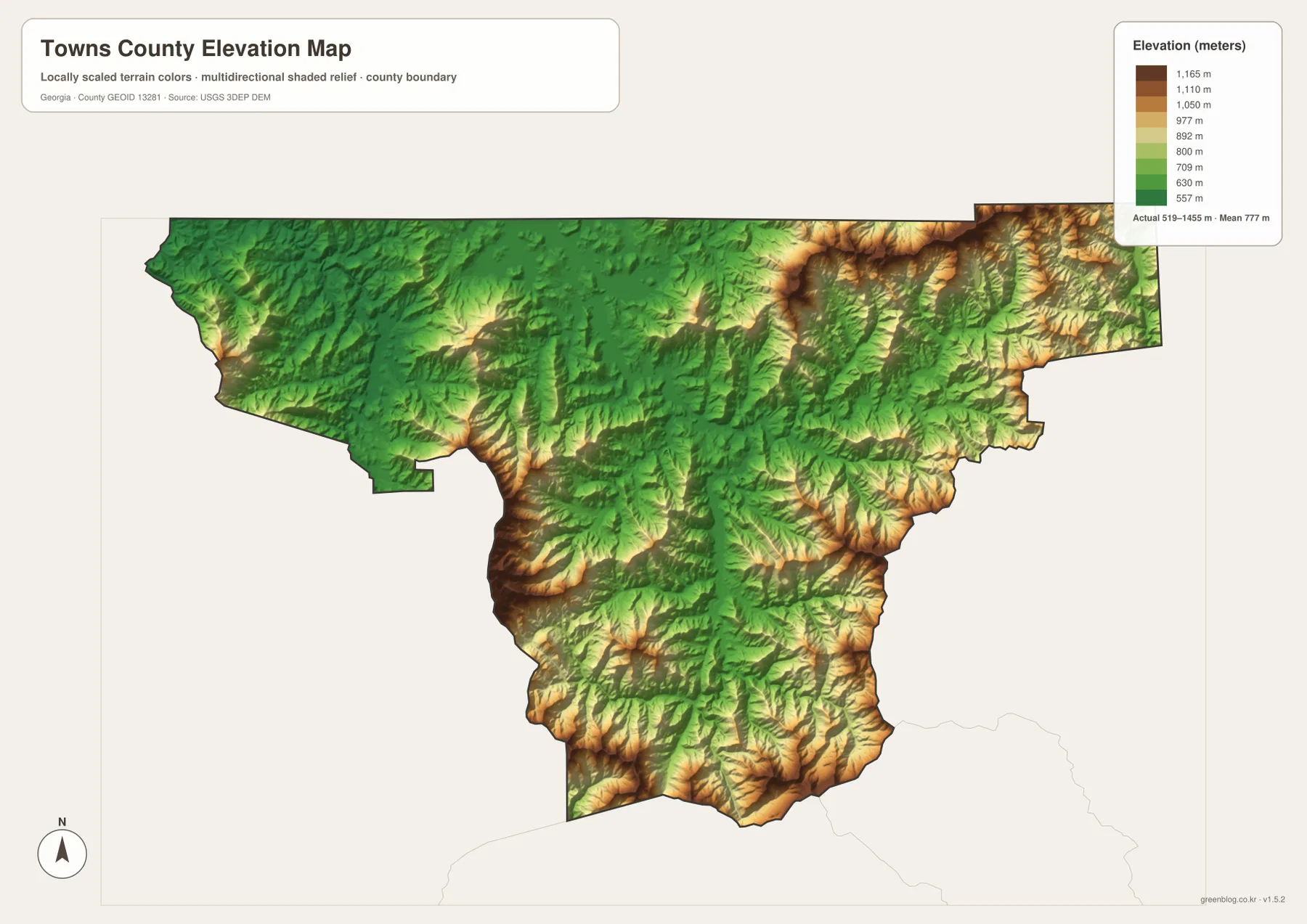
The northeastern edge contains some of the darkest high-elevation colors, and prominent high ridges also appear through the southern and southwestern parts of the county. By contrast, greener low-elevation areas spread around the lake basin and along several stream valleys. The resulting pattern is irregular rather than a simple north-to-south rise. A traveler can move from a low valley into much higher terrain over a short horizontal distance, which is why the road and water maps make more sense when the elevation surface is considered at the same time.
The color ramp on this map is locally scaled for Towns County. That means the legend should be read before comparing the colors with an elevation map from a different county; the same shade does not necessarily represent the same height on two separately scaled maps. The elevation surface is also generalized for county-level viewing. It is useful for understanding mountain relief and broad differences in height, but it is not survey-grade data for construction, property grading, engineering, or determining the exact elevation of a specific building site.
Which Towns County map is most useful for your task?
Choosing the right view depends on the question. The general map is the best starting point when you need roads, the county outline, Hiawassee, Young Harris, and nearby water features in one image. The city map is cleaner when the goal is simply to show that both major cities are concentrated in the north. For natural features, the terrain-and-water map gives far more detail about Lake Chatuge, the Hiwassee River, and the smaller creeks, while the elevation map explains the sharp change from valley floors to mountain ridges.
- General county map: use it for boundary orientation, major roads, Hiawassee and Young Harris, and the basic relationship between settlements and surrounding terrain.
- City distribution map: use it when a simple comparison of the two highlighted cities is more important than road or terrain detail.
- Terrain and water map: choose it for Lake Chatuge, the Hiwassee River, named creeks, smaller lakes, and the way streams occupy mountain valleys.
- Elevation map: choose it to compare the county’s roughly 519–1,455 meter elevation range and see where higher ridges surround lower valleys.
The WebP images in the article are lightweight previews intended for quick viewing in a browser. For larger copies, the download package contains the four original high-resolution JPG maps in A3 format. Keeping the map types together in one ZIP is useful when a project needs more than one layer of context—for example, a presentation can use the general map for location and the elevation map for terrain without forcing both kinds of information into a single crowded image.
Frequently Asked Questions
Where is Lake Chatuge on the Towns County maps?
Lake Chatuge is shown in the northern part of the county near Hiawassee, and the water map makes its shape especially clear. The lake extends beyond the county boundary, so the water feature and the administrative line should be read separately rather than assuming the shoreline follows the county edge.
How are Hiawassee and Young Harris positioned within the county?
Both are in the northern part of Towns County. Hiawassee is east of Young Harris and closely associated with the Lake Chatuge area, while Young Harris sits farther west. The city map gives the clearest comparison, and the general map adds the numbered routes that connect the two sides of the county.
Can the elevation map be used for survey or construction measurements?
No. It is a county-scale reference surface showing broad terrain differences, with an indicated range of about 519 to 1,455 meters. It is appropriate for understanding valleys and ridges, but site-specific engineering, grading, or property work requires authoritative survey-quality measurements.
Sources and reference data
These sources provide county background information and authoritative reference material for boundaries, hydrography, and elevation.
- U.S. Census Bureau QuickFacts for Towns County
- New Georgia Encyclopedia entry for Towns County
- U.S. Census Bureau TIGER/Line Shapefiles
- USGS National Hydrography
- USGS 3D Elevation Program
Map File Information
Save the Towns County general, city, water-and-terrain, and elevation maps as high-resolution A3 JPG files. The ZIP contains all four original JPG maps.
- Included Files: General county map, city distribution map, terrain and water map, elevation map
- File Type: ZIP containing four high-resolution A3 JPG files
Related Maps
Green Map creates custom-edited map images using open geographic data sources such as geoBoundaries, Natural Earth, OpenStreetMap, and government open data. These maps are edited visual materials, not raw data files, and are provided for education, documents, presentations, and graphic reference.