Toombs County sits in southeast Georgia, with Lyons serving as the county seat and Vidalia forming the larger urban and commercial center just to the west. The maps on this page make that northern concentration easy to see, but they also show a second side of the county: a long southern edge shaped by the Altamaha River, a dense network of creeks through the interior, and modest but visible elevation changes from upland ridges to low river corridors. Four high-resolution A3 JPG maps are available together in the download ZIP for readers who need larger files than the WEBP previews shown in the article.
The four views are designed to be read together rather than as interchangeable versions of the same map. The county map is the best starting point for roads, labeled places, and the outer boundary. The city-connections map strips away some detail so the relationship among Vidalia, Lyons, and Santa Claus stands out. The water map follows the Altamaha River, Ohoopee River, and named creeks, while the elevation map explains why many of those waterways occupy long green lowlands between slightly higher ridges. That combination gives a more useful picture of Toombs County than a simple outline alone.
Table of Contents
Roads and places concentrate around Vidalia and Lyons
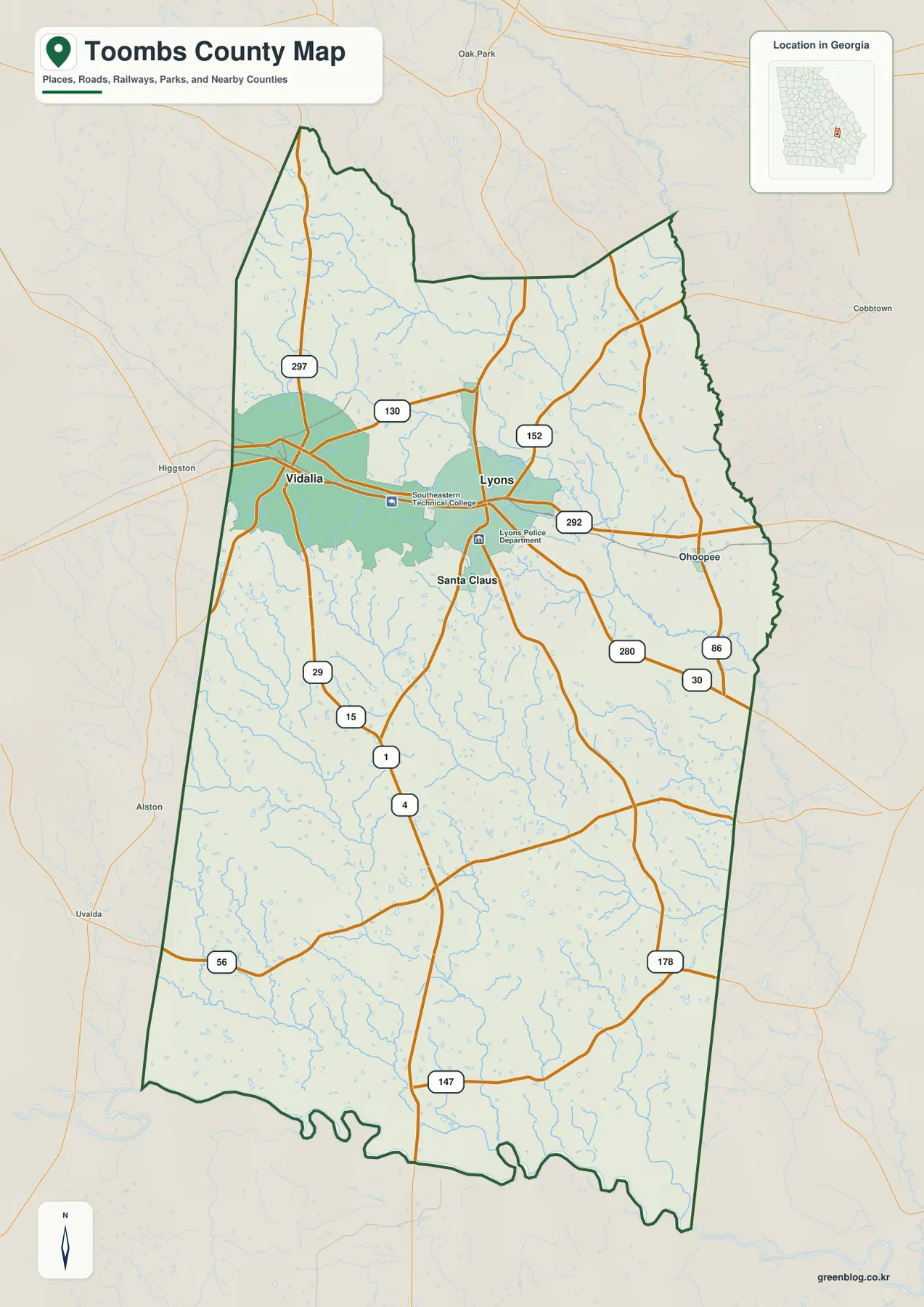
The general county map immediately draws attention to the north. Vidalia lies near the western side of the county, Lyons is a short distance east, and Santa Claus is positioned farther south of the two larger communities. Southeastern Technical College is labeled between Vidalia and Lyons, reinforcing how closely the two cities are connected in the mapped landscape. South of that cluster, named urban features become much less frequent and the map is dominated by roads, streams, and the county outline.
Several numbered routes converge in the same northern area. Route 280 provides the clearest east-west connection through Vidalia and Lyons, while the corridor marked 1 and 4 runs south from Lyons toward the lower half of the county. The map also labels the 15/29 corridor near Vidalia along with routes 130, 152, 292, 297, 56, 147, 178, 86, and 30 in different parts of the county. This is useful for understanding the broad road pattern, but it is not intended to replace a current navigation map that includes every local street, turn restriction, construction change, or address.
The county outline itself is also worth comparing with the road network. Much of the western and eastern edge is relatively simple, but the southern edge becomes irregular where the Altamaha River winds along the county. Roads cross the interior more directly than the natural boundary does, so the map makes a useful distinction between human travel corridors and the river-shaped edge of the county.
A compact northern city cluster with Vidalia as the map hub
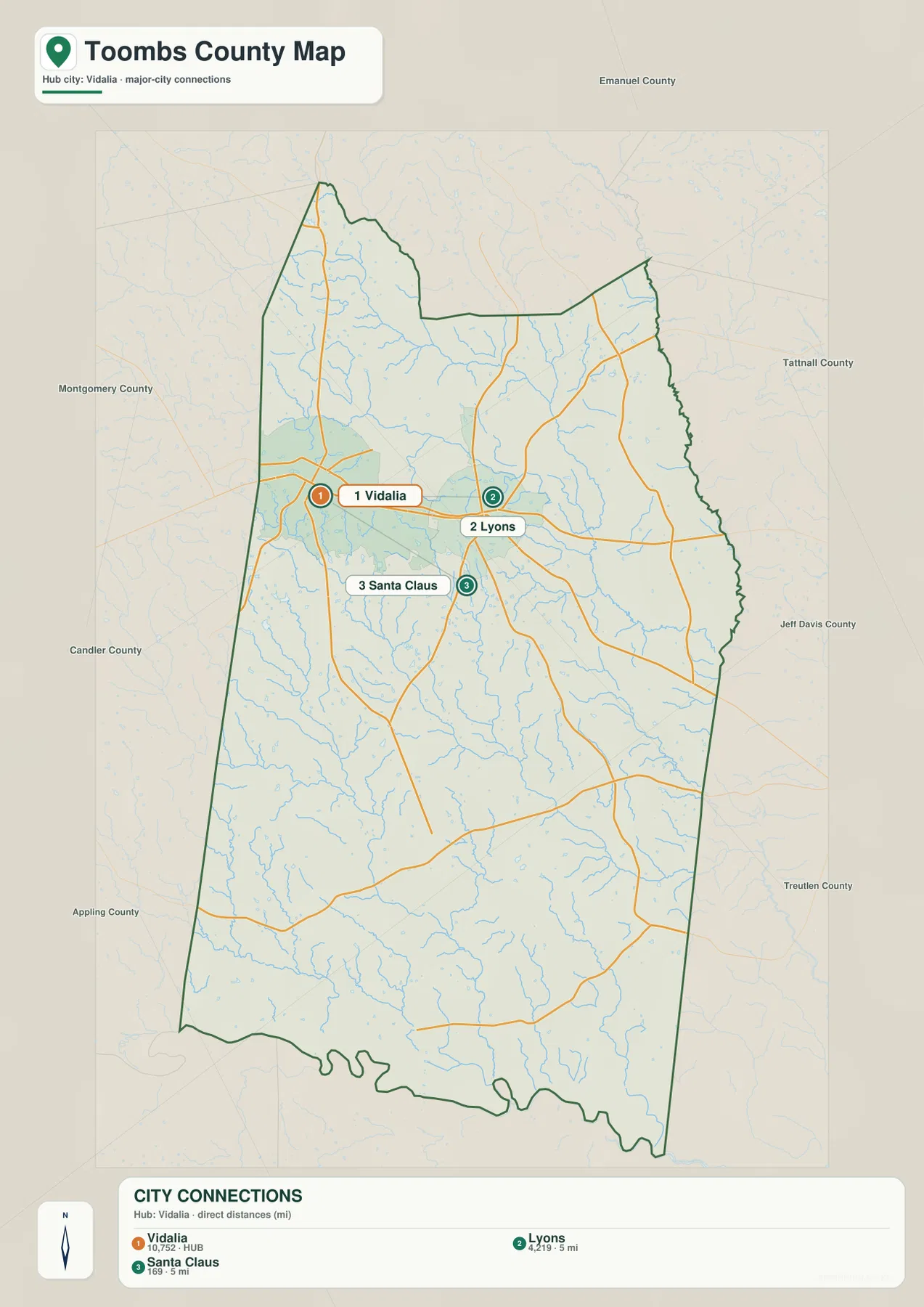
The city-connections map uses Vidalia as its hub and emphasizes only three places: Vidalia, Lyons, and Santa Claus. That simplification is helpful because it turns a busy county map into a quick comparison of direction and separation. The map gives Lyons a straight-line distance of about 5 miles from Vidalia and Santa Claus about 9 miles away. Those measurements are point-to-point distances, not driving distances, so a road trip between the same places will normally be longer.
Lyons appears east of Vidalia and functions as the county seat, while Santa Claus sits to the south. The arrangement shows why the northern part of Toombs County carries most of the city labels even though the county extends much farther toward the Altamaha River. Around the outside of the map, nearby county names such as Emanuel, Tattnall, Jeff Davis, Treutlen, Appling, Candler, and Montgomery provide regional orientation. They are useful reference labels, but the city map should not be treated as a legal adjacency diagram for deciding exact boundary relationships.
This view is especially useful when a reader already knows the city names but is unsure how they fit together. It makes clear that Vidalia and Lyons are close neighbors rather than opposite ends of the county, while Santa Claus is a smaller place positioned away from the main Vidalia–Lyons pair. That relationship can be difficult to notice on a statewide map where all three labels would occupy only a small area.
The Altamaha River shapes the southern edge while creeks divide the interior
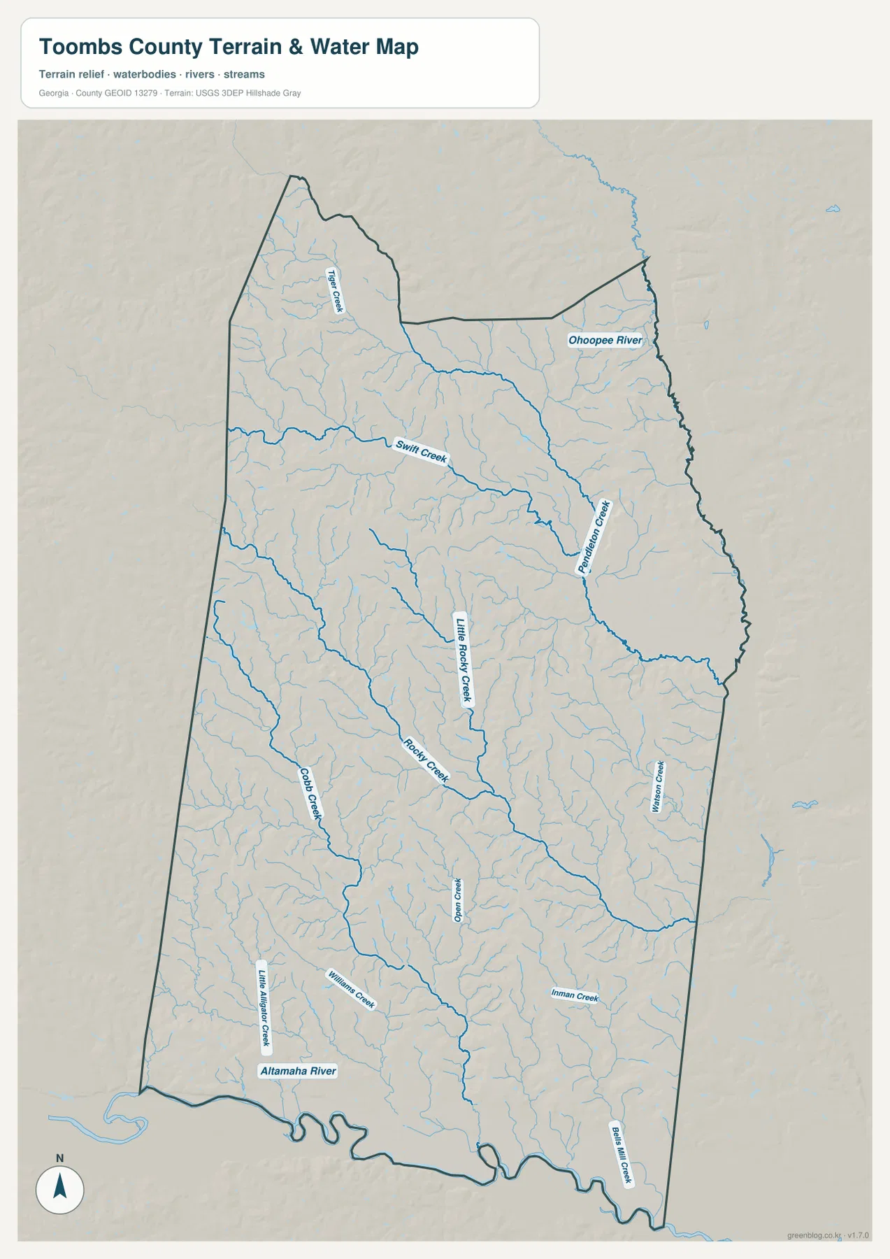
The terrain-and-water map changes the emphasis completely. Instead of cities and highways, the strongest feature is the Altamaha River following the southern edge of Toombs County. Its bends create the irregular lower boundary visible on the other maps. In the northeast, the Ohoopee River is labeled as another major watercourse, and named tributaries spread across the county between those larger river systems.
Several of the smaller streams are easy to follow because they are labeled directly on the map. Pendleton Creek runs through the northeastern part of the county, Swift Creek crosses the upper interior, and Tiger Creek is marked farther north. Rocky Creek and Cobb Creek help define drainage lines through the central and southwestern portions of the county. These are not isolated blue lines: many short unnamed branches feed into them, producing a dense branching pattern over much of the county.
That network explains why the county can look relatively simple on a road map but much more textured on the water map. Small valleys repeatedly cut through the uplands, and most parts of the county are not far from a creek or tributary. The map is useful for geographic reference and for understanding how the county drains, but it is not a flood-hazard map, a navigation chart, a parcel map, or a determination of regulated water boundaries. Those uses require the appropriate official datasets and local records.
Elevation ranges from about 20 to 93 meters across low rolling terrain
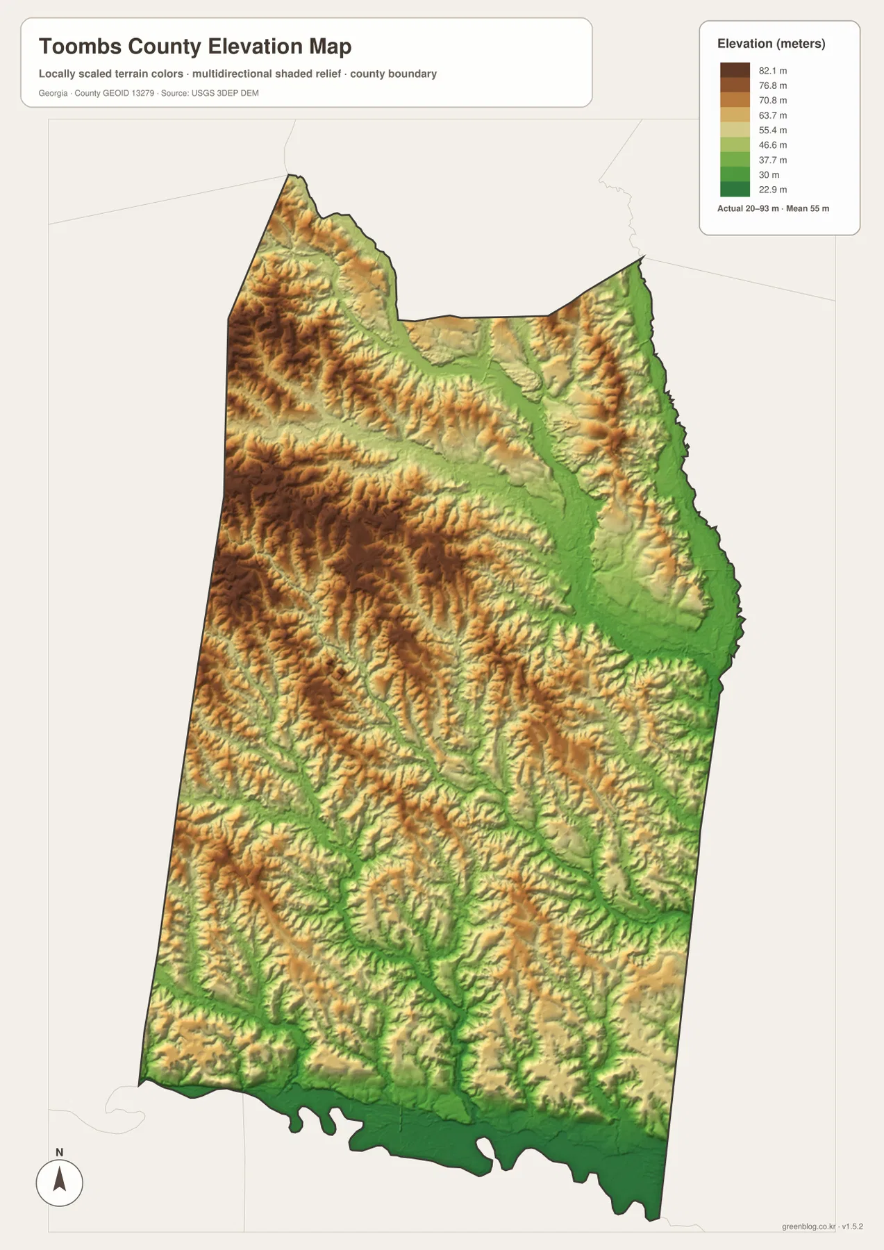
The elevation map shows a local range of roughly 20 to 93 meters, with a mapped mean near 55 meters. Those numbers confirm that Toombs County is not a mountainous landscape, yet the shaded relief reveals more variation than a flat outline map suggests. Higher brown and tan areas are most noticeable across the west and northwest, while lower green areas become broader toward the east and especially along the southern river corridor.
The most informative details are the long green fingers extending inland from the lower areas. They correspond closely with the creek network on the water map. Stream valleys form narrow low corridors, while the ground between them rises into gentle ridges and rolling uplands. In the northern half of the county, these ridges are subtle enough that they do not dominate the city map, but shaded relief makes them visible around the Vidalia–Lyons area and toward the northwest corner.
The lowest colors appear near the Altamaha River and other major drainage paths, which is consistent with the river occupying the county’s broad southern lowland. This elevation surface is intended for regional comparison. It is based on generalized elevation data and should not be treated as survey-grade information for construction, engineering, drainage design, or determining the exact height of a particular property.
County history adds context to the modern map
Toombs County was created in 1905 from portions of Emanuel, Montgomery, and Tattnall counties, according to the New Georgia Encyclopedia. Lyons is the county seat, while Vidalia developed into a regional trade center. The county’s modern settlement pattern still reflects that northern focus: the strongest cluster of roads, institutions, and city labels on the supplied maps sits around Lyons and Vidalia rather than along the sparsely labeled southern river edge.
Vidalia also gives the county one of its best-known cultural and agricultural associations. The sweet onion now sold under the Vidalia name was first cultivated in Toombs County in the 1930s, and the crop became closely tied to the identity of the city and surrounding region. That history is useful background, but it should not be confused with what the four maps are actually showing. The maps focus on geography—settlements, roads, waterways, and elevation—not current crop fields, land ownership, zoning, or agricultural production boundaries.
Santa Claus provides another distinctive name on the map. It is much smaller than Vidalia or Lyons and sits away from the main northern pair, which makes the city-connections view particularly useful. Together, the three labeled cities give the page a human scale: the county is not simply an abstract boundary, but a place where a close pair of urban centers transitions southward into a broader landscape of roads, creeks, low ridges, and the Altamaha River.
Choosing the right map for a specific question
Start with the county map when the question is simply, “Where are the main places and roads?” It gives the broadest overview and keeps city names, route numbers, waterways, and the county edge in one frame. Switch to the city map when the relationship among Vidalia, Lyons, and Santa Claus matters more than road detail. Because the connector distances are straight-line measurements, that map is best for orientation rather than trip planning.
The water map is the better choice for following the Altamaha River or tracing how creeks cross the interior. If the reader wants to understand why those creek corridors occupy certain paths, the elevation map adds the missing terrain information by showing low valleys and slightly higher uplands. Looking at the water and elevation maps side by side is particularly useful in Toombs County because the drainage network is one of the strongest patterns on both.
The WEBP images above are optimized as page previews. The downloadable ZIP contains the four original high-resolution JPG maps in A3 format, so the larger files are better suited to printing, classroom handouts, presentations, or offline reference. Each map keeps its own purpose rather than combining every layer into a single crowded image.
Frequently Asked Questions
Why do Vidalia and Lyons dominate the northern part of the map?
They are the two most prominent labeled urban centers in the supplied maps and sit only about 5 straight-line miles apart on the city-connections view. Lyons is the county seat, while Vidalia is the larger regional commercial center, so roads and labeled facilities are concentrated around this pair.
Which river explains the irregular southern boundary of Toombs County?
The Altamaha River follows much of the county’s southern edge on the water map. Its bends are reflected in the winding lower county outline. The map is useful for geographic reference, but an official boundary dataset should be used when an exact legal boundary is required.
Are the distances on the city map driving distances?
No. The city-connections map uses direct straight-line distances from Vidalia. Lyons is shown at about 5 miles and Santa Claus at about 9 miles, so road distance and travel time will differ from those figures.
Map File Information
The ZIP contains four high-resolution A3 JPG files for Toombs County: a county reference map, city-connections map, water map, and elevation map. Use the larger files when the WEBP page previews are not sufficient for printing or offline reference.
- File Type: ZIP containing four high-resolution A3 JPG files
Related Maps
Sources and References
County history and local context were checked against county and reference sources, while the map layers are interpreted with the appropriate federal boundary, hydrography, and elevation resources in mind. The links below provide authoritative starting points for readers who need the underlying data or additional local information.
- New Georgia Encyclopedia – Toombs County
- Official Toombs County website
- U.S. Census Bureau QuickFacts – Toombs County
- U.S. Census Bureau TIGER/Line Shapefiles
- USGS National Hydrography
- USGS 3D Elevation Program
Green Map creates custom-edited map images using open geographic data sources such as geoBoundaries, Natural Earth, OpenStreetMap, and government open data. These maps are edited visual materials, not raw data files, and are provided for education, documents, presentations, and graphic reference.