Rutherford County sits where North Carolina’s western Piedmont rises toward the Blue Ridge foothills, and the map changes noticeably from one side of the county to the other. Rutherfordton is the county seat near the center, Forest City forms a larger urban area to the southeast, and Spindale sits between them. Farther west, Lake Lure occupies a mountain-and-lake setting that looks completely different from the central road corridor, while Ellenboro, Bostic, Caroleen, and Cliffside provide smaller eastern and southeastern references.
This page provides three views of Rutherford County: a general map with boundaries, roads, and place labels; a ranked city-distribution map for six major communities; and a terrain-and-water map showing Broad River, Second Broad River, creeks, lakes, and shaded relief. You can download the matching high-resolution A3 JPG files together in one ZIP from the map file box below. The WebP images in the article are quick previews, while the JPG files are better for printing, enlarged inspection, and document use.
Table of Contents
Rutherfordton, Spindale, and Forest City form the clearest central road corridor
The general map is easiest to read by starting with Rutherfordton, Spindale, and Forest City. Rutherfordton lies near the center-south of the county, Spindale sits just southeast, and Forest City continues farther east. The three developed areas are close enough to form a recognizable central corridor, but the map keeps their labels and boundaries distinct. Rutherfordton is the administrative anchor, while Forest City is the more prominent urban reference on the city-distribution map.
Several numbered routes pass through or near this central area. Route 64 enters from the Lake Lure side in the west, route 108 approaches Rutherfordton from the southwest, and route 74 crosses the southern part of the county. Route 221 runs north from the southern edge, while routes 120 and 226 provide separate eastern and northeastern references. Reading these lines together makes the central-to-outer-county pattern much clearer.
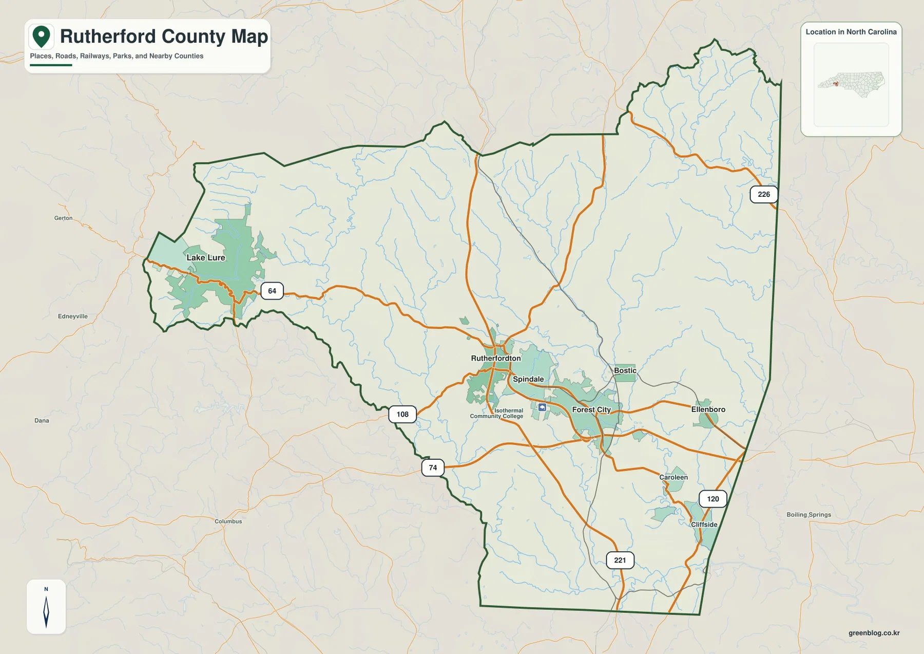
East of Forest City, Bostic and Ellenboro appear as separate small-town references, with Caroleen and Cliffside farther southeast. These places are not simply labels within one continuous Forest City urban area. The road map shows a series of smaller settlements spread across the eastern side, which is useful when a reader needs to distinguish the central urban corridor from the outer county.
The west is different again. Lake Lure sits within a narrow mountain setting where the county boundary, roads, and valleys all bend more sharply than they do around Rutherfordton or Forest City. That makes Lake Lure a better mountain-zone reference than a generic western-town label. The general map already hints at this change, and the terrain map makes it much more obvious.
Forest City ranks first while Rutherfordton remains the administrative reference
The supplied City Index ranks Forest City first, Spindale second, Rutherfordton third, Lake Lure fourth, Ellenboro fifth, and Ruth sixth. The ranking comes from the provided city map and is used here as a map reference rather than as an independently updated population table.
The geographic arrangement matters more than the ranking alone. Forest City, Spindale, and Rutherfordton are grouped in the central-southern portion of the county. Lake Lure is far to the west in the mountain section, Ellenboro lies on the eastern side, and Ruth is positioned near the central-northeastern area. These separated locations create a central urban cluster plus distinct western and eastern references.
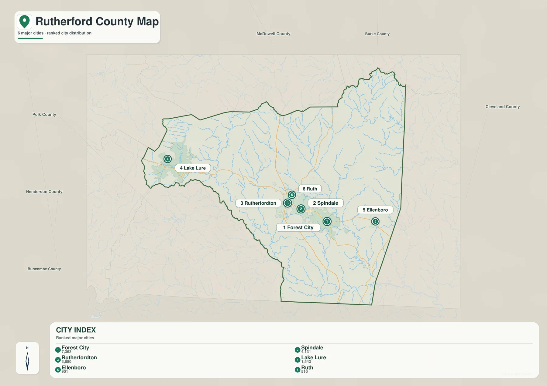
County names around the outside include McDowell, Burke, Cleveland, Polk, Henderson, and Buncombe. They help place Rutherford County within western North Carolina, but the city graphic is not a legal adjacency survey. The county outline should be checked first, with external labels used only for regional orientation.
The city-distribution map does not show driving mileage or connector distance. Its markers indicate rank and location only. Actual travel between Forest City and Lake Lure, or between Rutherfordton and Ellenboro, should be checked on the general road map rather than estimated from the spacing of the city markers.
Broad River and Second Broad River separate foothill lowlands from the mountain side
The terrain-and-water map reveals the physical structure behind the road network. Broad River runs through the western and southwestern foothills, while Second Broad River crosses a more central-eastern path. Looking at both rivers together prevents the county from being reduced to one drainage corridor. They help explain why the western valleys and the central foothill settlements do not form one simple landscape.
Smaller waterways add detail across the interior. Cove Creek and Mountain Creek are labeled west of center, Cleghorn Creek appears near Lake Brooks, and Cane Creek stands out in the northeast. Frog Creek is visible farther south and east. These names fill many areas that look comparatively quiet on the general map and show how frequently shallow valleys cut through the foothill terrain.
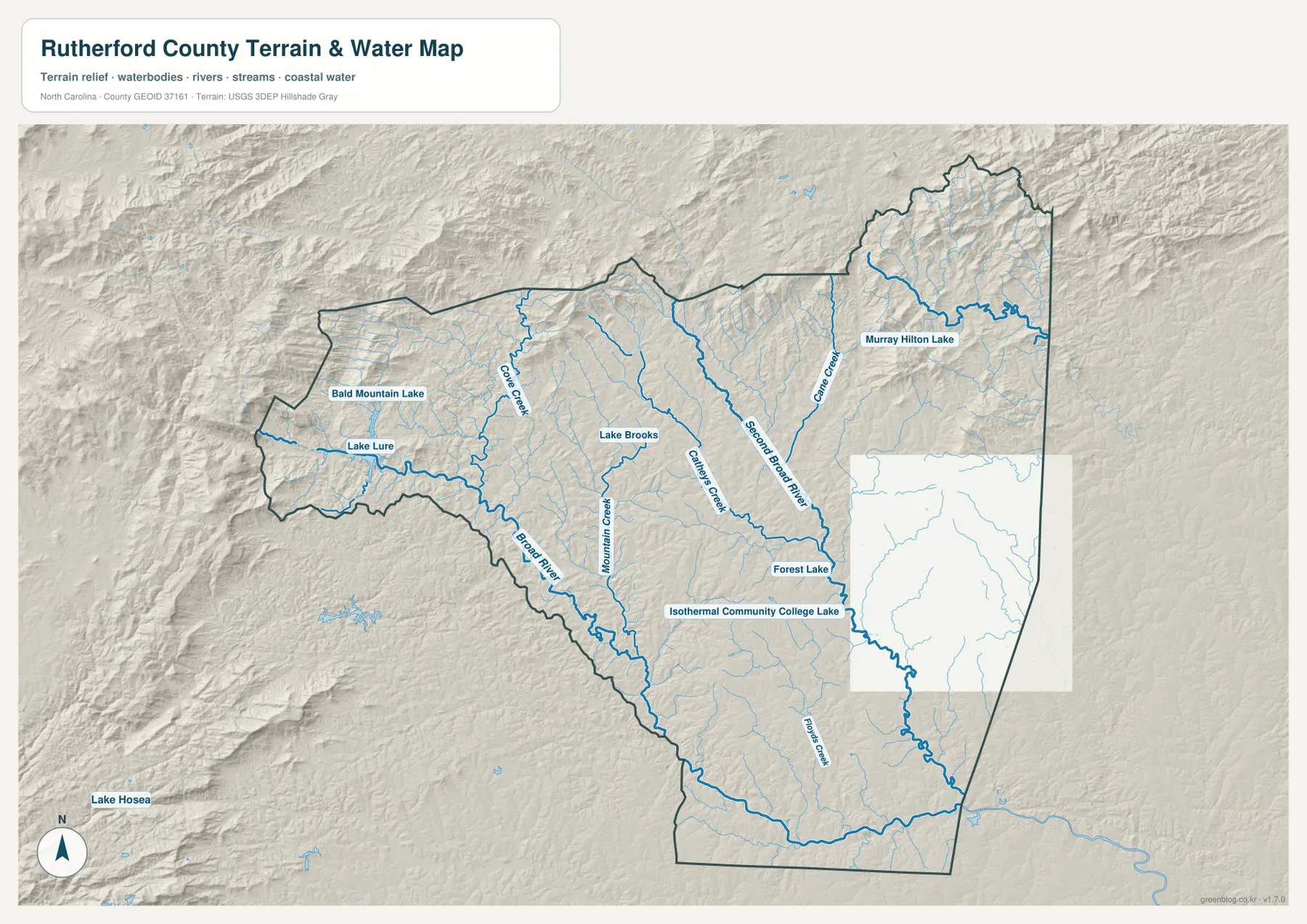
The lake pattern also changes by region. Lake Lure and Bald Mountain Lake sit in the western mountain section, while Murray Hilton Lake appears in the northeast. Lake Brooks, Forest Lake, and Isothermal Community College Lake are closer to the central settlement area. No single lake represents the whole county; the useful feature is the way water bodies are distributed across very different terrain settings.
Relief shading is much rougher in the west and northwest than around Rutherfordton and Forest City. The Lake Lure side has tightly packed ridges and valleys, while the central-southern foothills are visibly gentler. That transition matches the county background preserved in the land-use-plan source. This remains a general terrain-and-water reference, not a flood-hazard map, navigation chart, parcel survey, or engineering-grade elevation product.
Lake Lure, the central urban corridor, and the eastern small towns need separate map references
Lake Lure is the easiest part of Rutherford County to separate visually. It sits far west of the central cities, surrounded by stronger relief and a distinctive lake-and-valley pattern. Treating it as a separate mountain-tourism zone is more accurate than describing it as just another town along the same urban corridor.
The central section is defined by Rutherfordton, Spindale, and Forest City. Rutherfordton provides the county-seat reference, Forest City is ranked first on the city map, and Spindale occupies the space between them. Reading all three names together gives a more realistic picture of the central settlement pattern than county-seat status alone.
The eastern and southeastern side is more dispersed. Bostic, Ellenboro, Caroleen, and Cliffside are separated from one another and from the main central cluster. Second Broad River and several smaller tributaries also cross this side of the county. The result is a pattern of small settlements and drainage corridors rather than one continuous urban area.
The package preserves Rutherford County’s Land Use Plan as a county-specific reference. It provides background for the distinction between Rutherfordton’s administrative role, Forest City’s larger urban function, and the Lake Lure mountain setting. The detailed road, city, river, creek, and lake descriptions in this rewrite are based primarily on the three maps supplied in the package.
Use the road map for settlements and the water map for the foothill transition
The general county map is the best choice when you need Rutherfordton, Forest City, Spindale, Lake Lure, Ellenboro, Bostic, and the numbered road network in the same view. Routes 64, 108, 74, 221, 120, and 226 provide useful directional anchors from the mountain side through the central corridor and toward the eastern edge.
The city-distribution map is cleaner when the goal is simply to compare the six ranked communities. It shows Forest City first, Spindale second, Rutherfordton third, and Lake Lure far to the west. Because route detail is reduced, the map is better for settlement distribution than for travel planning.
The terrain-and-water map is the stronger reference for Broad River, Second Broad River, Cane Creek, Cove Creek, Mountain Creek, and the county’s lakes. Lake Lure, Bald Mountain Lake, Murray Hilton Lake, Lake Brooks, and Forest Lake are easier to identify without a dense road network competing for attention. The shaded relief also makes the western mountain-to-central-foothill transition clear.
The download ZIP contains three high-resolution A3 JPG files corresponding to the general county map, city-distribution map, and terrain-and-water map shown on this page. These files are larger than the WebP previews and are intended for printing, enlarged viewing, and document use. They are general geographic reference maps, so legal boundary decisions, surveying, flood determinations, navigation, and engineering-grade elevation work should rely on the appropriate official technical data.
Frequently Asked Questions
Why does Forest City rank above Rutherfordton even though Rutherfordton is the county seat?
County-seat status describes an administrative role, not city size. The supplied city map ranks Forest City first, Spindale second, and Rutherfordton third. Rutherfordton remains the best administrative reference, while Forest City and Spindale help explain the larger central urban corridor.
What waterways are shown besides Broad River?
The water map labels Second Broad River, Cane Creek, Cove Creek, Cleghorn Creek, Mountain Creek, and Frog Creek. It also shows Lake Lure, Bald Mountain Lake, Murray Hilton Lake, Lake Brooks, Forest Lake, and Isothermal Community College Lake.
What files are included in the Rutherford County download ZIP?
The archive contains three high-resolution A3 JPG files corresponding to the general county map, the six-city distribution map, and the terrain-and-water map showing rivers, creeks, lakes, and shaded relief.
Map File Information
The ZIP contains three high-resolution A3 JPG files matching the Rutherford County general map, city-distribution map, and terrain-and-water map shown on this page.
- Included Files: Use only the versions confirmed in the article and supplied images
- File Type: Use the confirmed download contents
- Intended Use: Printing, education, presentations, and map-based projects
Related Maps
Sources and References
- Rutherford County Land Use Plan
- U.S. Census Bureau – TIGER/Line Shapefiles
- USGS – National Hydrography
- USGS – 3D Elevation Program
These references provide county background, boundary and road data, hydrographic context, and elevation source information. The maps on this page are designed as general-purpose geographic references and downloadable map resources, so readers who need current legal boundaries or detailed technical water and elevation data should also consult the original agency sources.
Green Map creates custom-edited map images using open geographic data sources such as geoBoundaries, Natural Earth, OpenStreetMap, and government open data.
These maps are edited visual materials, not raw data files, and are provided for education, documents, presentations, and graphic reference.