Fannin County occupies a mountainous corner of northern Georgia where towns, roads, rivers, lakes, and steep elevation changes all interact within a relatively compact area. Blue Ridge is identified in the supplied article as the county seat, while McCaysville, Morganton, Mineral Bluff, and Epworth provide other useful place references. The maps on this page let you move from a broad county-and-road view to a simplified city-connection view, then to detailed water and elevation maps. After reviewing the previews, you can download a ZIP containing four high-resolution A3 JPG maps for printing, presentations, classroom use, and local geographic reference.
The terrain is the key to understanding the county. Roads between Blue Ridge, McCaysville, and Morganton follow a landscape of narrow valleys and high ridges rather than a flat grid. Blue Ridge Lake creates a large water reference east and southeast of Blue Ridge, while the Toccoa River and many smaller creeks occupy lower corridors between mountains. The elevation map reports an actual range from about 308 to 1,263 meters, with a mean of 646 meters. That nearly 1,000-meter spread explains why straight-line distance, road distance, and the visual closeness of two towns can tell different stories in Fannin County.
Table of Contents
Blue Ridge, McCaysville, and the Main Road Pattern
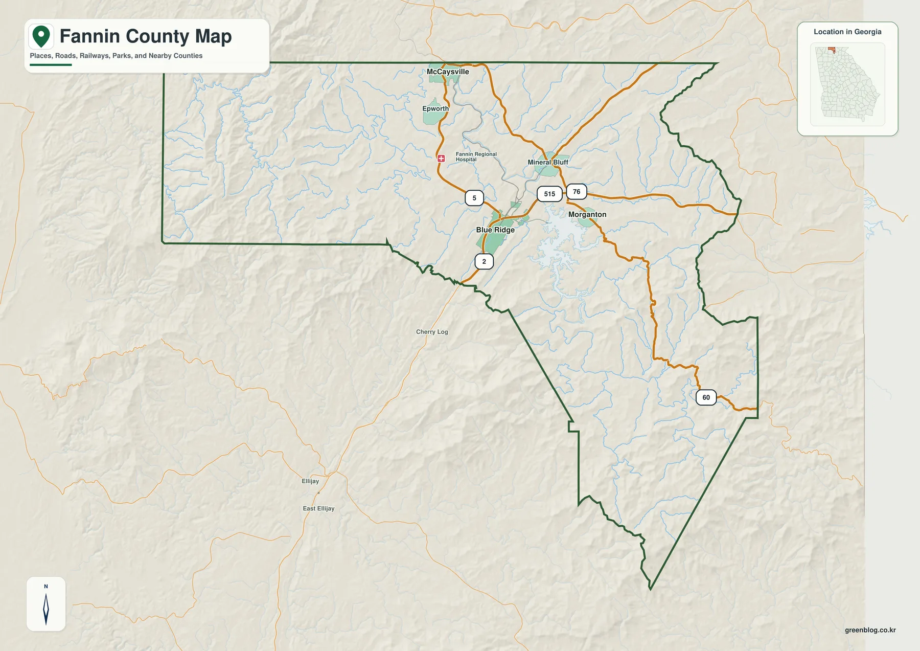
The general map places Blue Ridge in the north-central part of the county, close to several important numbered routes. Route 5 runs north from the Blue Ridge area toward Epworth and McCaysville. Route 2 appears south of Blue Ridge, while 515 and 76 are prominent east of town and around Morganton. Route 60 crosses the southeastern part of the county before continuing beyond the boundary. At this scale, the road numbers are most useful for orientation—understanding which direction one community lies from another—rather than for turn-by-turn driving or locating individual addresses.
Moving north from Blue Ridge, Epworth appears first and McCaysville is located near the county’s northern edge. East of Blue Ridge are Mineral Bluff and Morganton, with Blue Ridge Lake forming a large and irregular water body just south of Morganton. The supplied article identifies McCaysville as a state-line community near Tennessee, a relationship that is easy to understand when its position is compared with the northern county boundary. The map also labels Fannin Regional Hospital north of Blue Ridge along the Route 5 corridor, providing another visual landmark within the county’s populated northern section.
The western and southern parts of the county look different from the cluster around Blue Ridge. Fewer town labels appear, while the background relief and stream network become more visually dominant. Cherry Log is labeled outside the southwestern side of the county, and Ellijay and East Ellijay appear farther south. These surrounding references help place Fannin County within the mountain region of north Georgia without turning the map into a detailed regional road atlas. The emphasis remains on the county boundary, its principal settlements, major roads, and the terrain that shapes movement between them.
A useful way to read this map is to notice how towns follow the more navigable corridors between ridges. Blue Ridge and Morganton sit near the lake-and-river system, while the route toward McCaysville runs through a narrow northern corridor. The shaded relief around the county boundary makes it obvious that much of the land between these places is not broad level ground. This physical setting becomes clearer on the elevation map, but even the general map suggests why roads take curved paths and why communities occupy distinct pockets rather than forming one continuous urban area.
Straight-Line Connections from McCaysville to Blue Ridge and Morganton
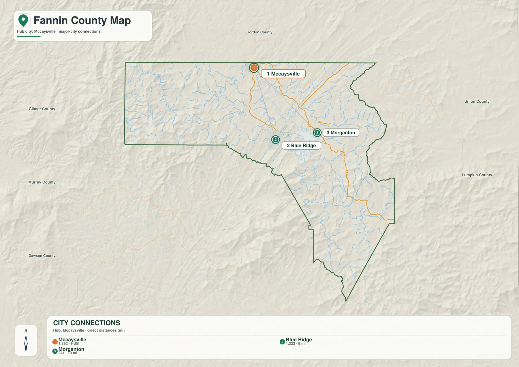
The city map strips away much of the detail and focuses on three places: McCaysville, Blue Ridge, and Morganton. Its CITY CONNECTIONS panel lists McCaysville at 1,392 as the hub, Blue Ridge at 1,323 and about 8 miles away, and Morganton at 241 and about 10 miles away. The map explicitly describes these as direct distances, meaning straight-line measurements rather than road mileage. That distinction matters in a mountain county, where a road may bend around ridges, follow a river valley, or descend through a gap instead of taking the shortest geometric route.
McCaysville is the northern point in this three-place comparison. Blue Ridge lies to the south, while Morganton is east of Blue Ridge and closer to the northern side of Blue Ridge Lake. The layout provides a simple way to explain the main settlement triangle in the county’s northern half. Someone looking only at the city map can quickly compare the towns, then switch to the general map to see which numbered roads connect their areas and to the water map to understand how the lake and river system affect the landscape between them.
Names outside the county boundary—such as Gilmer County, Gordon County, Union County, Lumpkin County, Murray County, and Dawson County—are included as regional reference labels. They help place the Fannin County city pattern within the broader mountain region rather than serving as a legal boundary diagram. Union and Lumpkin are shown to the east and southeast, while Gilmer and other county references appear to the west and south. The result is a cleaner view of how McCaysville, Blue Ridge, and Morganton occupy the northern part of a county that stretches much farther south into sparsely labeled mountain country.
| City-map entry | Value shown | Direct distance from McCaysville | Map position |
|---|---|---|---|
| McCaysville | 1,392 | Hub | Northern edge of Fannin County |
| Blue Ridge | 1,323 | About 8 mi | North-central county, road hub |
| Morganton | 241 | About 10 mi | East of Blue Ridge, north of Blue Ridge Lake |
Blue Ridge Lake, the Toccoa River, and Mountain Creeks
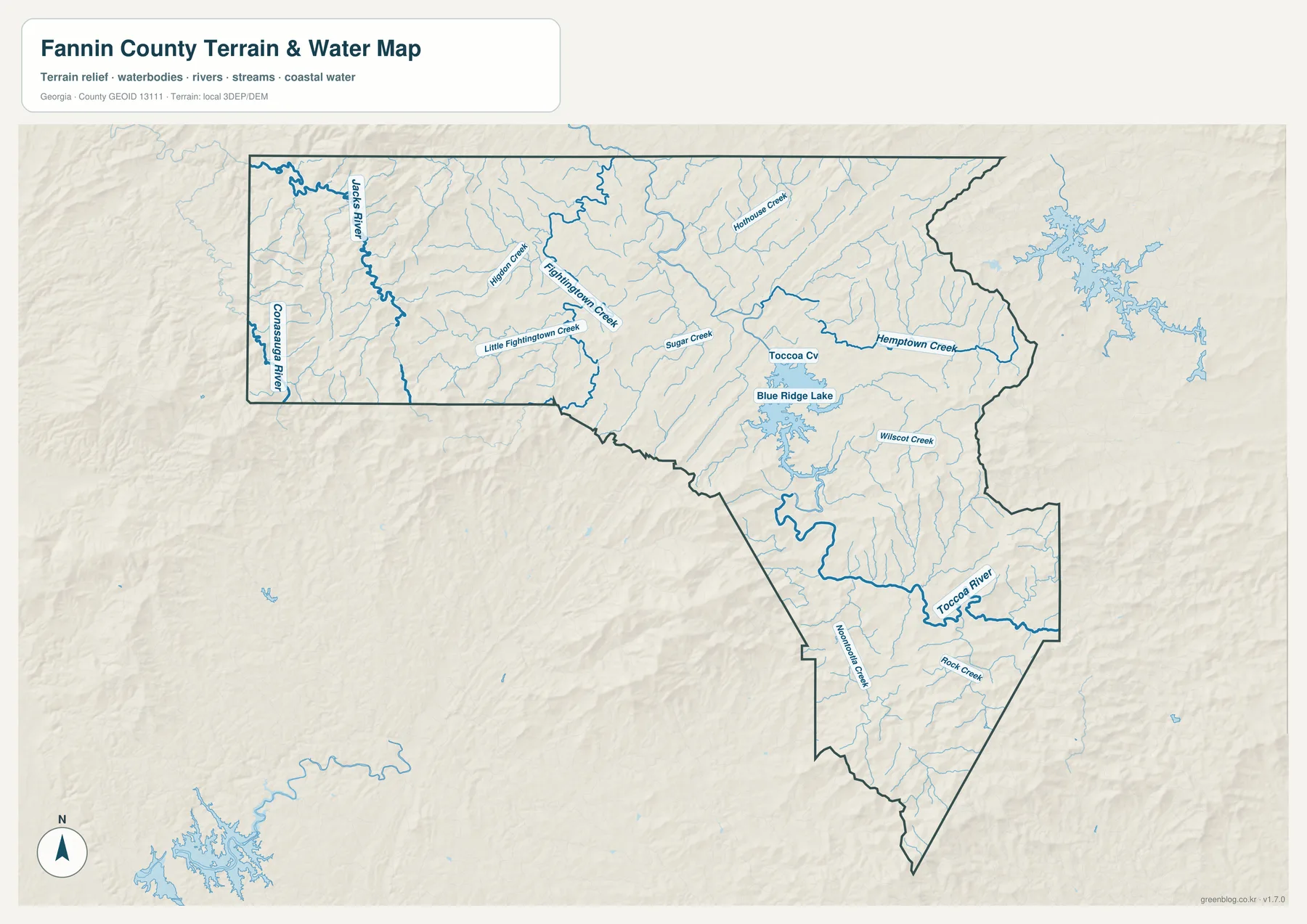
Blue Ridge Lake is the most visually dominant water body on the county water map. Its shoreline branches into numerous narrow arms, reflecting the way water occupies valleys between surrounding ridges. North of the lake, a labeled Toccoa watercourse continues through the central part of the county, and the Toccoa River is clearly labeled again farther south and southeast. This lake-and-river system provides an important geographic reference for Morganton, Blue Ridge, and the interior valleys of the county.
The western side contains a different set of prominent waterways. Jacks River is drawn as a thick blue line in the northwest, and the Conasauga River is labeled near the western boundary. Between those rivers and the central county are Fightingtown Creek, Little Fightingtown Creek, and other smaller tributaries. Hothouse Creek and Sugar Creek appear farther east, while Hemp Town Creek is labeled in the northeastern half. South and east of Blue Ridge Lake, Wilscot Creek, Noontootla Creek, and Rock Creek add more named valleys to an already dense network.
The large number of thin blue lines is just as important as the better-known names. They show how frequently small streams occupy the low spaces between ridges. On the map, tributaries repeatedly join larger creeks and rivers, while the shaded terrain rises sharply on both sides. This visual relationship is especially clear around Jacks River in the west and along the Toccoa system in the center and south. It is one reason the county feels highly dissected: many narrow valleys divide the mountain mass into separate ridges rather than one broad elevated plateau.
This is a county-scale water reference, not a flood-zone, parcel, navigation, or regulatory map. A creek shown in blue confirms a mapped water feature and helps establish location, but the image does not determine whether a specific property is in a regulatory flood area, whether a channel is navigable, or where a legal water boundary lies. For those questions, current specialized data is required. For geographic reading, however, the map is highly useful because it connects familiar names such as Blue Ridge Lake and the Toccoa River with the many smaller streams that shape the surrounding mountain terrain.
A 308–1,263 Meter Elevation Range Across Steep Mountain Relief
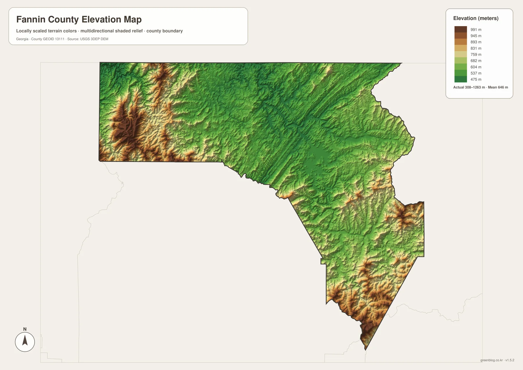
The elevation map reports an actual range of approximately 308 to 1,263 meters and a mean elevation of 646 meters. That is a large vertical range within one county. Green tones mark lower terrain, while yellow, tan, and brown areas rise toward the higher ridges. Even without labels for individual peaks, the map immediately shows that Fannin County is not uniformly elevated. Deep valleys cut through high mountain blocks, and some of the strongest relief occurs in the west, northwest, southeast, and southern tip of the county.
The western and northwestern sections contain broad areas of brown and tan shading with closely spaced ridges. Narrow green valleys cut between them, matching the kind of river corridors seen around Jacks River on the water map. The southeastern and southern parts also contain high ridges, including strong brown relief along the tapered southern end of the county. By contrast, much of the central and northeastern interior is greener, especially along the larger river-and-lake corridors. The pattern is complex rather than a simple rise from one side of the county to another.
Blue Ridge Lake and the Toccoa River sit within lower corridors surrounded by higher ground. When the water and elevation maps are compared, the relationship is straightforward: streams occupy valleys, while ridges form the higher divides between drainage lines. The same is true around Noontootla Creek in the south and Jacks River in the northwest. This comparison provides a better explanation of Fannin County’s landscape than listing elevation numbers alone because it shows where the lower terrain actually occurs and how it connects to the named waterways.
The elevation surface is intended for county-wide visual comparison, not engineering or survey work. The colors and shaded relief generalize the terrain so that ridges and valleys are easy to see at map scale. A construction project, drainage design, property survey, or precise point-elevation question requires more detailed elevation data or field measurement. For regional understanding, the map’s 308–1,263 meter range and 646-meter mean provide a concise summary of just how mountainous the county is.
Which Fannin County Map Works Best for Your Question?
Use the general county map first when the question involves towns, roads, and overall location. It shows Blue Ridge, McCaysville, Morganton, Mineral Bluff, and Epworth together with Routes 2, 5, 60, 76, and 515. That combination is useful for explaining how the main settlement corridor is arranged and which roads leave Blue Ridge in different directions. The city map becomes more useful when you want a cleaner comparison of McCaysville, Blue Ridge, and Morganton without the distraction of every road and stream.
For physical geography, begin with the water map and then compare the same area on the elevation map. Blue Ridge Lake and the Toccoa River are obvious anchors, but Jacks River, the Conasauga River, Noontootla Creek, and the smaller tributaries reveal how many valleys cut across the county. On the elevation map, those valleys appear as lower green corridors between higher ridges. This pairing is particularly effective for a geography lesson, a presentation about the mountain environment, or a local-history project that needs to explain why transportation and settlement follow particular corridors.
The city-connection map also helps explain a common mountain-region issue: straight-line distance is not the same as driving distance. McCaysville to Blue Ridge is labeled at about 8 miles direct, and Morganton at about 10 miles direct from the same hub. Those numbers are useful for relative spacing, but the general and elevation maps show why actual travel can follow longer, curved routes. Rather than treating each map as a separate product, readers can use the four views together to move from simple location to the physical reasons behind the county’s road and settlement pattern.
A County Established in 1854, Viewed Through Its Mountain Geography
The supplied article identifies Fannin County as having been established in 1854. It also notes mountain tourism, forests, rivers, rail excursions, lodging, and state-line travel as important parts of the county’s regional context. The maps here do not attempt to measure the tourism economy or locate every attraction. Instead, they provide the geographic framework behind those topics: a county seat at Blue Ridge, a state-line community at McCaysville, a major lake and river system, and dramatic elevation differences across the county.
Blue Ridge works as the central orientation point because several roads converge nearby and the lake lies close to the east and southeast. McCaysville provides the northern state-line reference, while Morganton helps locate the north side of Blue Ridge Lake. Beyond these towns, the water and elevation maps make clear that much of the county consists of ridges, forested-looking mountain terrain, and narrow creek valleys. The maps therefore help connect familiar place names with the physical geography that separates and links them.
Fannin County is also a good example of why a county boundary alone is not enough to explain a mountain region. The same outline contains high western ridges, a large central-eastern lake, northern towns near a state line, and long southern valleys cut by streams such as Noontootla Creek. A visitor looking only at Blue Ridge might miss how far the county extends into sparsely labeled mountain terrain. By moving among the general, city, water, and elevation maps, the county becomes easier to understand as a connected landscape rather than a list of towns.
Frequently Asked Questions
Which towns and places are labeled on the general map?
Blue Ridge, McCaysville, Morganton, Mineral Bluff, and Epworth are prominent labels. The city-connection map simplifies the view to McCaysville, Blue Ridge, and Morganton and gives direct distances from the McCaysville hub.
What are the main water features shown in Fannin County?
Blue Ridge Lake and the Toccoa River are major central references. The map also labels Jacks River, Conasauga River, Fightingtown Creek, Little Fightingtown Creek, Hothouse Creek, Sugar Creek, Hemp Town Creek, Wilscot Creek, Noontootla Creek, and Rock Creek.
What elevation range is shown on the terrain map?
The map reports an actual range of about 308 to 1,263 meters and a mean of 646 meters. It is intended for comparing county-wide ridges and valleys, not for survey-grade elevation at a specific property or construction site.
What is included in the downloadable archive?
The ZIP contains four high-resolution A3 JPG files: the general county map, city-connection map, water-and-terrain map, and elevation map. The files are suitable when you need a larger image than the webpage previews.
Map File Information
Fannin County A3 Map Files
- Included Files: 4 high-resolution A3 JPG map files shown in this article
- File Type: JPG files in a ZIP archive
- Intended Use: Printing, education, presentations, and map-based projects
Related Maps
Sources and Reference Material
- U.S. Census Bureau TIGER/Line Shapefiles – county boundary and geographic reference data
- USGS National Hydrography – river and stream reference data
- USGS 3D Elevation Program – elevation data
- U.S. Census Bureau QuickFacts: Fannin County – county statistics reference
- New Georgia Encyclopedia: Fannin County – county history and regional background
Green Map creates custom-edited map images using open geographic data sources such as geoBoundaries, Natural Earth, OpenStreetMap, and government open data. These maps are edited visual materials, not raw data files, and are provided for education, documents, presentations, and graphic reference.