Fayette County lies south of Atlanta, with Fayetteville and Peachtree City serving as the two most prominent reference points on the supplied maps. This page separates the county into four useful views rather than forcing roads, cities, waterways, and terrain into one crowded image. The general map shows the boundary and main roads, the city map compares five communities from a Peachtree City hub, the water map names lakes and creeks, and the elevation map shows the county’s 150–310 meter relief. After reviewing the maps, you can download four high-resolution A3 JPG originals in one ZIP for printing, classroom work, presentations, or local research.
The maps reveal a county with several distinct centers rather than one continuous city. Fayetteville sits near the middle and slightly east of center, Peachtree City occupies the southwest, Tyrone is northwest, Woolsey is southeast, and Brooks is near the southern end. State routes connect those places while numerous creeks cut through the landscape. The west side contains several named lakes around Peachtree City, and the elevation view shows higher rolling ground in the northwest with lower valleys extending through the center, east, and south. Reading those features together gives a clearer sense of Fayette County than a boundary outline alone.
Table of Contents
Fayetteville, Peachtree City, and the Main Road Pattern
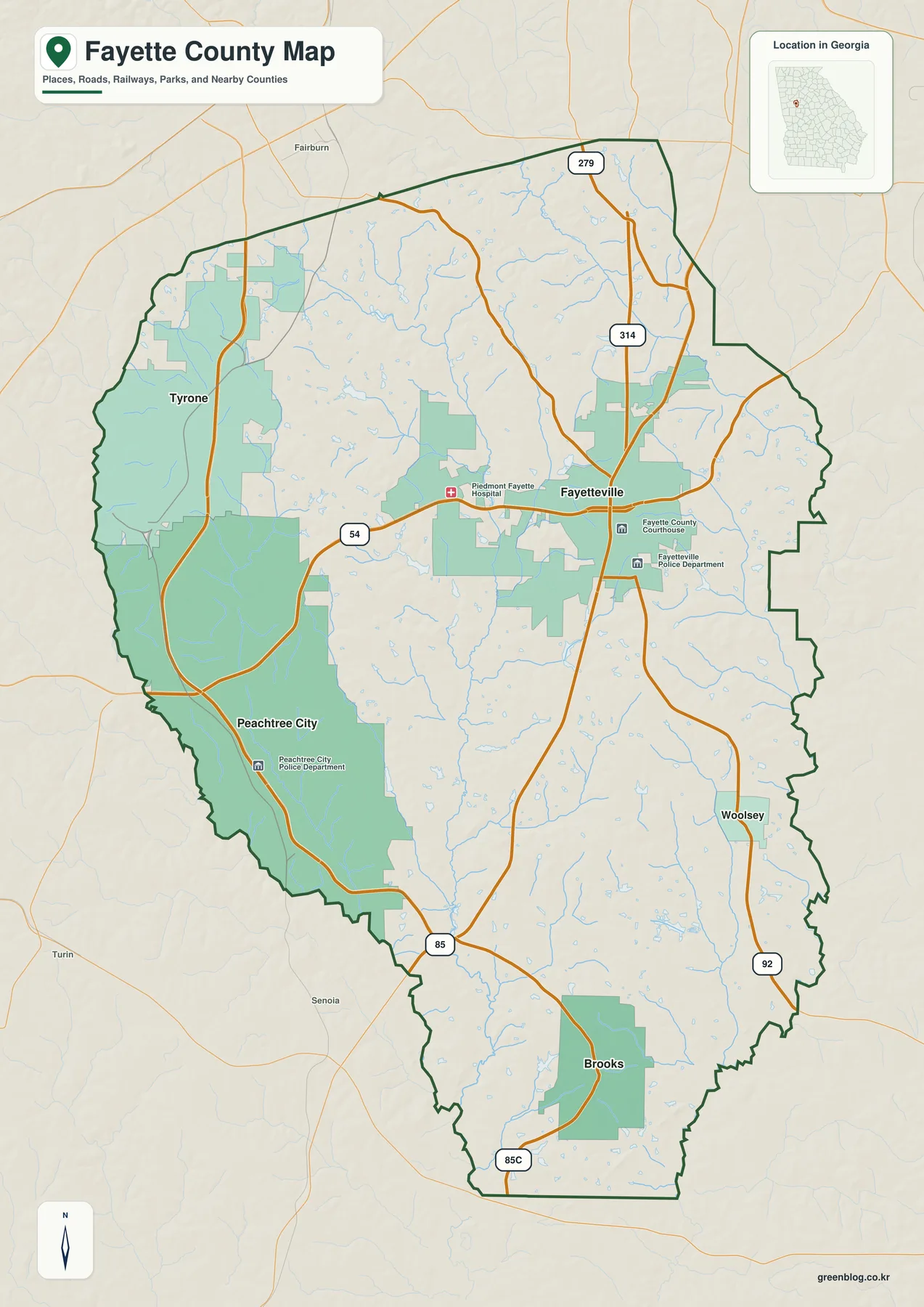
Fayetteville is a natural starting point on the general map. It appears near the center-east of the county, with the county courthouse, police department, and Piedmont Fayette Hospital marked nearby. Peachtree City is farther southwest and occupies a broad area on the western side. Tyrone sits near the northwestern boundary, while Woolsey and Brooks provide useful reference points for the southeast and south. Outside the county, Fairburn appears to the north and Senoia and Turin appear to the southwest, helping place Fayette County within the larger area south of Atlanta.
State Route 54 is one of the clearest east-west connections on the map because it runs through Fayetteville toward Peachtree City. Routes 85 and 92 extend through the central and eastern parts of the county toward the south, while 279 and 314 provide additional north-side references. The map also labels 85C near the southern section. These numbered roads are useful for understanding the county at a regional scale: they show which cities share the same general corridor and how the road network reaches the county edges. The map is not designed to replace current street-level navigation, so small roads, turn restrictions, and real-time traffic should be checked elsewhere when planning a drive.
Water is visible even on the general reference map. Small blue tributaries cross much of the county, and the Peachtree City side contains several larger water bodies. The streams are important because they break up the rolling terrain between roads and communities. Their names are easier to read on the dedicated water map, while the elevation view shows how many of those channels occupy lower ground. Starting with the general map and then moving to the specialized views keeps the county’s road, settlement, and natural features connected without overloading a single image.
Straight-Line Connections from Peachtree City
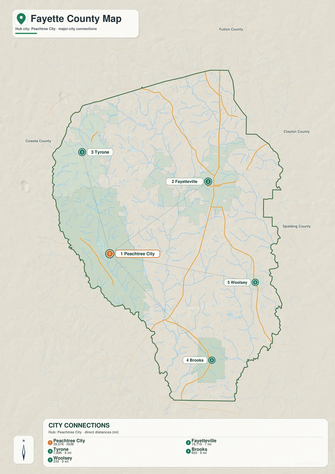
The city map chooses Peachtree City as the hub and draws direct connectors to Fayetteville, Tyrone, Woolsey, and Brooks. The mileage shown here is straight-line distance, not a driving route. Fayetteville is labeled about 7 miles from the hub, Tyrone about 6 miles, and both Woolsey and Brooks about 9 miles. A road trip between the same points can be longer because streets do not follow those straight connectors. The value of the map is comparison: it shows how tightly the main communities fit within the county and which direction each lies from Peachtree City.
The map also includes a city-size index: Peachtree City 39,576, Fayetteville 19,719, Tyrone 7,896, Brooks 603, and Woolsey 235. Those figures are reproduced from the supplied city map and are best treated as the values used for the map’s ranking rather than as a replacement for the latest official population estimate. Current demographic figures can be checked through the Census source listed below. The visual point is clear even without focusing on the numbers: Peachtree City and Fayetteville are the largest urban references, Tyrone forms a smaller northwest center, and Brooks and Woolsey are much smaller communities in the southern part of the county.
Neighboring county labels help explain the setting. Fulton County is shown north of Fayette County, Clayton County to the east, Spalding County to the southeast, and Coweta County to the west. Peachtree City and Tyrone therefore sit closer to the Coweta side of the county, while Fayetteville is more central and eastward. Woolsey and Brooks occupy the southern half. This layout is useful when a reader is trying to understand Fayette County as part of the Atlanta-area region rather than as an isolated outline.
| City | Straight-line distance from Peachtree City | Position on the map |
|---|---|---|
| Fayetteville | about 7 mi | central to east-central |
| Tyrone | about 6 mi | northwest |
| Woolsey | about 9 mi | southeast |
| Brooks | about 9 mi | south |
Lakes Around Peachtree City and Creeks Across the County
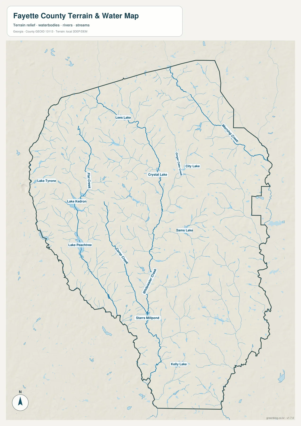
The west side of the water map is especially easy to recognize because several named lakes cluster around the Peachtree City area. Lake Tyrone is shown farther north, Lake Kedron lies below it, and Lake Peachtree is farther south. Flat Creek and Line Creek run through the same general western portion of the county. In the interior, Crystal Lake provides a useful reference, while City Lake and Gingercake Creek appear closer to Fayetteville. Sams Lake is labeled farther east, and the southern half includes Starrs Millpond and Kelly Lake. These features make the county’s water geography far more detailed than it appears on the road map.
Morning Creek forms a noticeable named waterway in the northeastern and eastern part of the county. Whitewater Creek follows a long corridor through the center toward the south, and numerous unnamed tributaries branch into those larger channels. The map shows how dense the drainage network is even in areas where no large lake is present. That is useful for geographic orientation because a community may be close to several small creeks even when the general map emphasizes roads and city names instead.
This map is a county-scale water reference, not a flood-zone, property, navigation, or legal-boundary product. The location of a blue stream line does not determine whether a parcel is in a regulated flood area, whether a waterway can be navigated, or where a legal shoreline begins. Specialized current data should be used for those decisions. Here, the map is best used to locate named lakes and creeks, compare the western lake system with the streams crossing the rest of the county, and connect those waterways to the lower valleys visible on the elevation map.
A 150–310 Meter Elevation Range Across Rolling Terrain
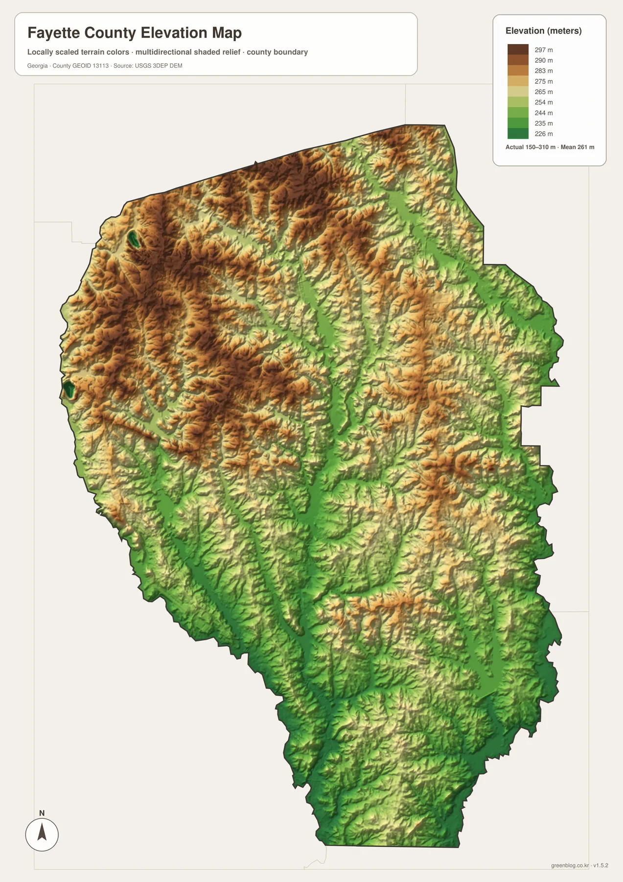
The elevation map reports an actual range of roughly 150 to 310 meters, with a mean of 261 meters. Fayette County is not mountainous, but the shaded relief shows a surprisingly textured landscape. Brown and tan colors dominate much of the northwest and west, where ridges and higher rolling ground are more common. Green areas trace lower terrain through many central valleys and become broader toward parts of the east and south. The difference is large enough to make creek corridors and the higher ground between them visible at county scale.
Narrow green valleys repeatedly cut through the central part of the map. When compared with the water view, many of those low corridors make sense as places where creeks and tributaries collect. The northwest contains more tightly packed ridges, while the southern end trends lower overall. This relationship helps explain why a simple road map can hide an important part of the county: two communities may look close together in plan view even though the land between them contains a sequence of small ridges and drainage valleys.
The elevation colors and hillshade are generalized for county-wide comparison. They should not be used to determine the exact elevation of a building site or to design roads, drainage systems, grading, or other engineering work. Those tasks require detailed elevation data and, in many cases, field surveying. For education, regional orientation, or a presentation about local physical geography, however, the map clearly shows where the county is higher, where the lower valleys concentrate, and how terrain relates to the stream network.
What Changes When Roads, Cities, Water, and Relief Are Compared
A reader interested in the county’s main settlements can begin with Fayetteville and Peachtree City on the general map. Route 54 provides an obvious connection between them, and the locations of Tyrone, Woolsey, and Brooks become easy to place around that pair. The city map then strips away much of the extra detail and adds straight-line distances, making it useful when the question is how far the major communities are from the Peachtree City hub. That is a different task from finding a driving route, and the simple connectors make the distinction clear.
For physical geography, the water and elevation maps tell the more useful story. The cluster of lakes around Peachtree City contrasts with the long creek corridors crossing the center and east. On the relief map, lower ground follows many of those valleys, while higher rolling terrain occupies much of the northwest. Seeing the maps together shows that Fayette County is not only an Atlanta-area suburban county; it is also a landscape shaped by small watersheds, lakes, ridges, and stream valleys between its communities.
The best map therefore depends on the question. A classroom slide explaining county location may need the general map, while a project comparing municipalities may benefit from the city-connections view. A report about lakes or drainage should start with the water map, and a terrain discussion is clearer with the elevation view. The downloadable A3 JPG files preserve each of those focused views at a larger size than the webpage previews, so they can be printed or placed into documents without relying on a single crowded image.
Frequently Asked Questions
Are the city-map distances driving distances?
No. The city map uses straight-line distances from Peachtree City. Fayetteville is shown at about 7 miles, Tyrone at 6 miles, and Woolsey and Brooks at about 9 miles each. Actual driving mileage depends on the road network and can be longer.
Which named lakes appear around Peachtree City?
The water map labels Lake Tyrone, Lake Kedron, and Lake Peachtree on the western side of the county. Other named waters include Crystal Lake, City Lake, Sams Lake, Kelly Lake, and Starrs Millpond, along with several named creeks.
What elevation range is shown for Fayette County?
The supplied elevation map states an actual range of approximately 150 to 310 meters and a mean of 261 meters. It is intended for county-scale comparison of higher ground and lower valleys rather than survey-grade measurements at a specific property.
What files are included in the download?
The ZIP includes four high-resolution A3 JPG files covering the county reference map, city connections, waterways, and elevation. Each file focuses on a different part of Fayette County, so you can use one map or combine several in the same project.
Map File Information
Fayette County A3 Map Files
- Included Files: General county, city, water, and elevation maps
- File Type: Four high-resolution A3 JPG files bundled in one ZIP archive
- Intended Use: Printing, education, presentations, and map-based projects
Related Maps
Sources and Reference Material
- Fayette County official profile – county background and local information
- U.S. Census Bureau QuickFacts: Fayette County – current official statistics
- U.S. Census Bureau TIGER/Line – county boundary and geographic reference data
- USGS National Hydrography – rivers, streams, and water features
- USGS 3D Elevation Program – elevation data
- New Georgia Encyclopedia: Fayette County – county history and regional background
Green Map creates custom-edited map images using open geographic data sources such as geoBoundaries, Natural Earth, OpenStreetMap, and government open data. These maps are edited visual materials, not raw data files, and are provided for education, documents, presentations, and graphic reference.