Mecosta County in west-central Lower Michigan is easiest to learn by starting with Big Rapids and then expanding outward. US-131 runs north and south along the western side of the county, while M-20 leaves Big Rapids and crosses the interior toward communities and lake country farther east. Paris, Stanwood, Morley, Mecosta, Barryton, and the Canadian Lakes area provide useful location markers, while the Muskegon River, Little Muskegon system, Chippewa River system, and numerous inland lakes add a second set of landmarks. The four high-resolution JPG originals used for this article are available together in the download box below.
Rather than treating the maps as interchangeable versions of the same sheet, it helps to give each one a specific job. The general county map is best for communities, roads, and the county frame. The city-connections map simplifies direction and spacing from Big Rapids. The terrain-and-water map brings rivers and lake groups forward, and the elevation map shows a county range of roughly 250 to 387 meters. Moving through them in that order makes it much easier to connect roads with river valleys, lake districts, and higher interior ground.
Table of Contents
Big Rapids and US-131 provide a practical starting point for the county
Big Rapids is the most prominent settlement on the supplied county map and the simplest place to begin orientation. US-131 passes just west of the city and provides a strong north-south reference, leading toward Paris to the north and toward Stanwood and Morley to the south. M-20 leaves Big Rapids for the east, creating an easy way to follow the county from its western population center into the interior. Once those two highways are located, many of the smaller roads and place names become much easier to place.
Farther east, Mecosta appears in the central-eastern part of the county, while Barryton sits much closer to the northeastern edge. M-66 offers another north-south reference on the eastern side, complementing the US-131 corridor in the west. The Canadian Lakes area lies south of Mecosta and is visually distinctive because several water bodies cluster close together. On the general map, these roads, communities, and lake shapes work together as a set of landmarks rather than a single dominant center.
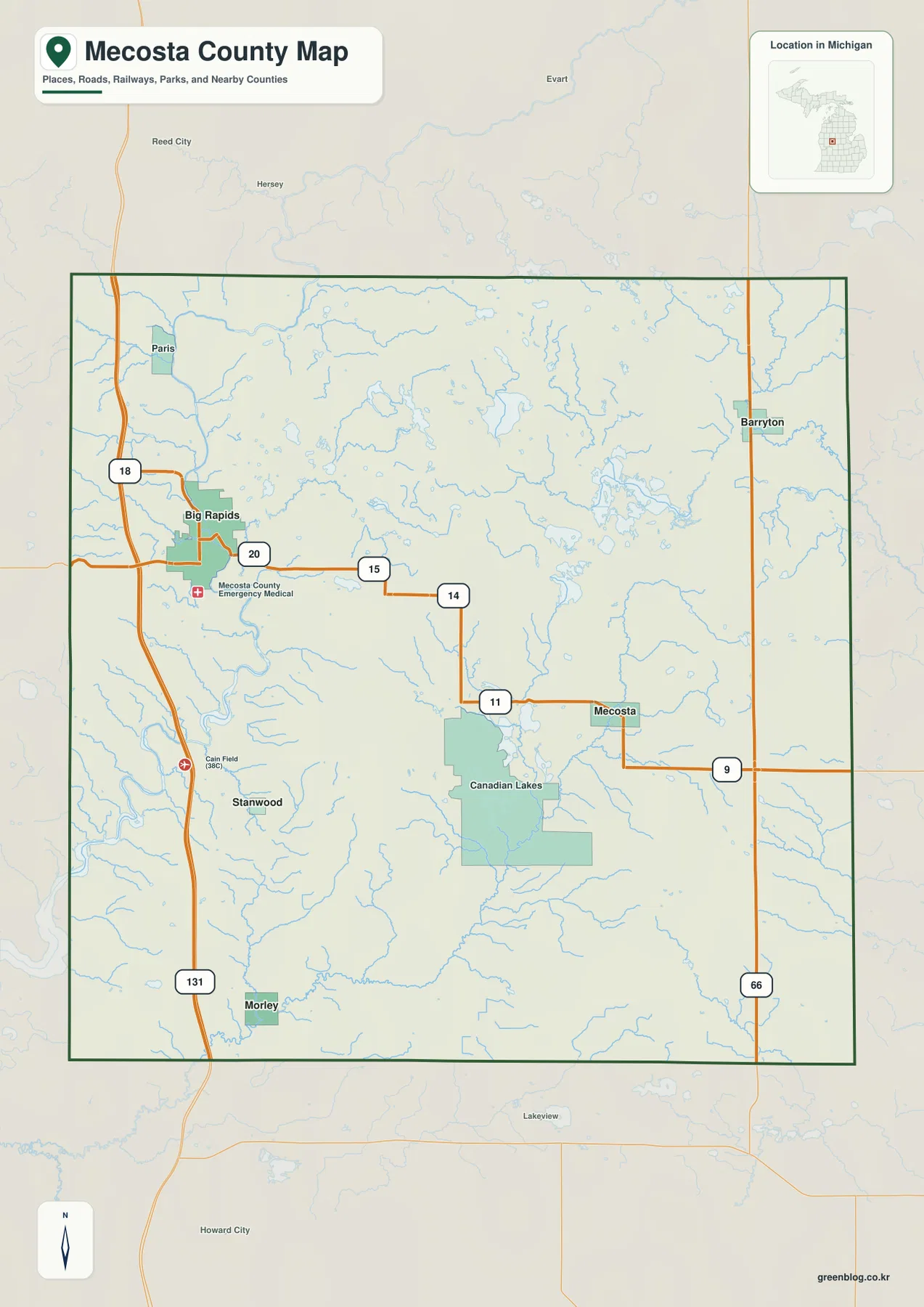
The western side feels more concentrated because several named communities line up near US-131. Paris, Big Rapids, Stanwood, and Morley can be followed in a relatively simple north-south sequence. The central and eastern interior is more dispersed, with settlements separated by lake groups, streams, and rural land. That contrast is useful for trip planning and classroom orientation, although this map is not a substitute for live navigation or current road-closure information. For an actual drive, the latest routing data should still be used.
Straight-line distances show how the main communities spread out from Big Rapids
The city-connections map reduces the county to a simple Big Rapids-centered diagram and highlights Stanwood, Mecosta, Morley, and Barryton. Stanwood lies to the south near the US-131 side, while Morley is farther south and somewhat east. Mecosta sits east of Big Rapids in the interior, and Barryton is positioned toward the northeastern edge. This arrangement is useful when the goal is not to study every road but simply to understand which direction each community lies from the county’s largest city.
The map lists direct distances of about 8 miles from Big Rapids to Stanwood, 13 miles to Mecosta, 14 miles to Morley, and 17 miles to Barryton. These are straight-line measurements between locations, not driving distances along the road network. A trip by car may be longer because highways and local roads do not follow a perfectly direct path. Used correctly, the values are a quick comparison tool: Stanwood is the closest of the four highlighted communities, while Barryton is the farthest and also has the strongest northeastern orientation.
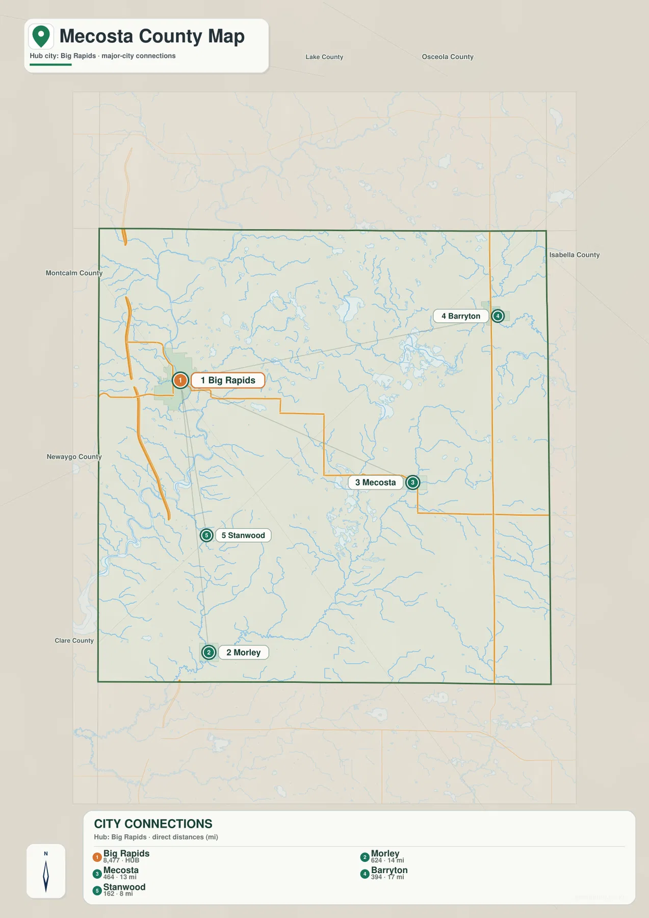
After those relationships are familiar, the detailed county map becomes less crowded. One can follow US-131 south from Big Rapids toward Stanwood and Morley, then shift east toward Mecosta and farther northeast toward Barryton. Canadian Lakes can be remembered as a major water-rich area south of Mecosta, which helps bridge the city map with the terrain-and-water view. This layered approach is more effective than trying to memorize every place label at once.
The Muskegon River, Canadian Lakes, and northeastern lake country divide the water landscape
The Muskegon River is the strongest single water feature on the western side of Mecosta County. It bends through the Big Rapids area and continues along a broad valley that stands out clearly on both the water and elevation maps. Smaller tributaries join the river from the interior, so the western side is not simply a road corridor centered on US-131. The river provides an equally important geographic reference, especially when comparing the location of Big Rapids with nearby low ground.
South and southeast of the central county, the Little Muskegon system introduces another set of channels, while the Lake Mecosta and Canadian Lakes area contains a dense group of inland waters. Blue Lake and other nearby lake shapes make this part of the map visually distinctive. The Canadian Lakes district is therefore easier to recognize by the repeated water bodies than by a single highway. Finding Mecosta first and then moving south toward the lake group is a practical way to locate the area on both the road and water maps.
The northern and northeastern portions contain Chippewa Lake, Martiny Lake, Big Evans Lake, and the Chippewa River system. Here the pattern differs from the broad Muskegon River corridor: multiple lakes and smaller channels share the visual emphasis instead of one large river. Barryton provides a useful settlement reference for this side of the county. Mecosta County Parks describes the county as having more than 100 lakes, rivers, and streams, which matches the number of water features visible across the supplied terrain-and-water map.
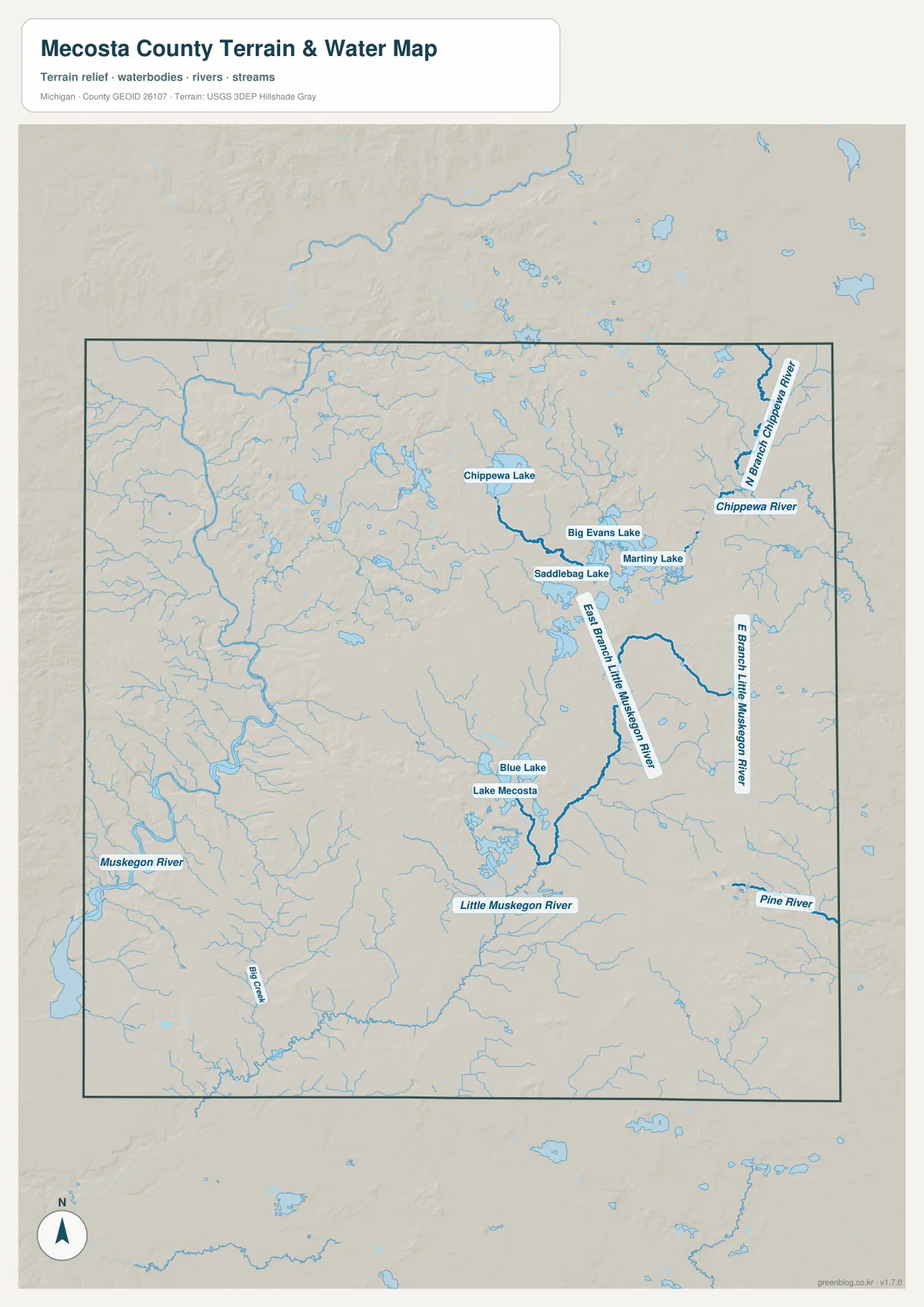
This map should be used as a geographic water reference rather than a real-time hydrology or navigation product. It can show where a river or lake lies and how tributaries relate at county scale, but it does not report current streamflow, flood depth, lake level, boating channels, or wetland jurisdiction. Those questions require the latest information from the appropriate agencies. For general study, the sheet is most valuable for showing how a large western river corridor differs from the lake-rich central and northeastern interior.
Elevation separates the low Muskegon corridor from higher north-central ground
The elevation map shows a county-wide range of roughly 250 to 387 meters. The clearest low area is the green band following the Muskegon River along the western side. Its curves closely match the river on the water map, making the relationship between the valley and the major channel easy to recognize. Lower ground also extends through parts of the south and southeast where smaller streams occupy broad green areas.
Higher ground becomes most prominent across the north-central interior, where tan and brown shades cover a broad upland zone. Additional elevated ridges appear in parts of the central-western and eastern interior. The county does not simply rise from west to east or north to south; lower valleys cut between areas of higher land, and lake basins occupy some of the lower pockets. Around Lake Mecosta and Canadian Lakes, water, lower terrain, and nearby ridges appear close together, giving the central county a varied surface.
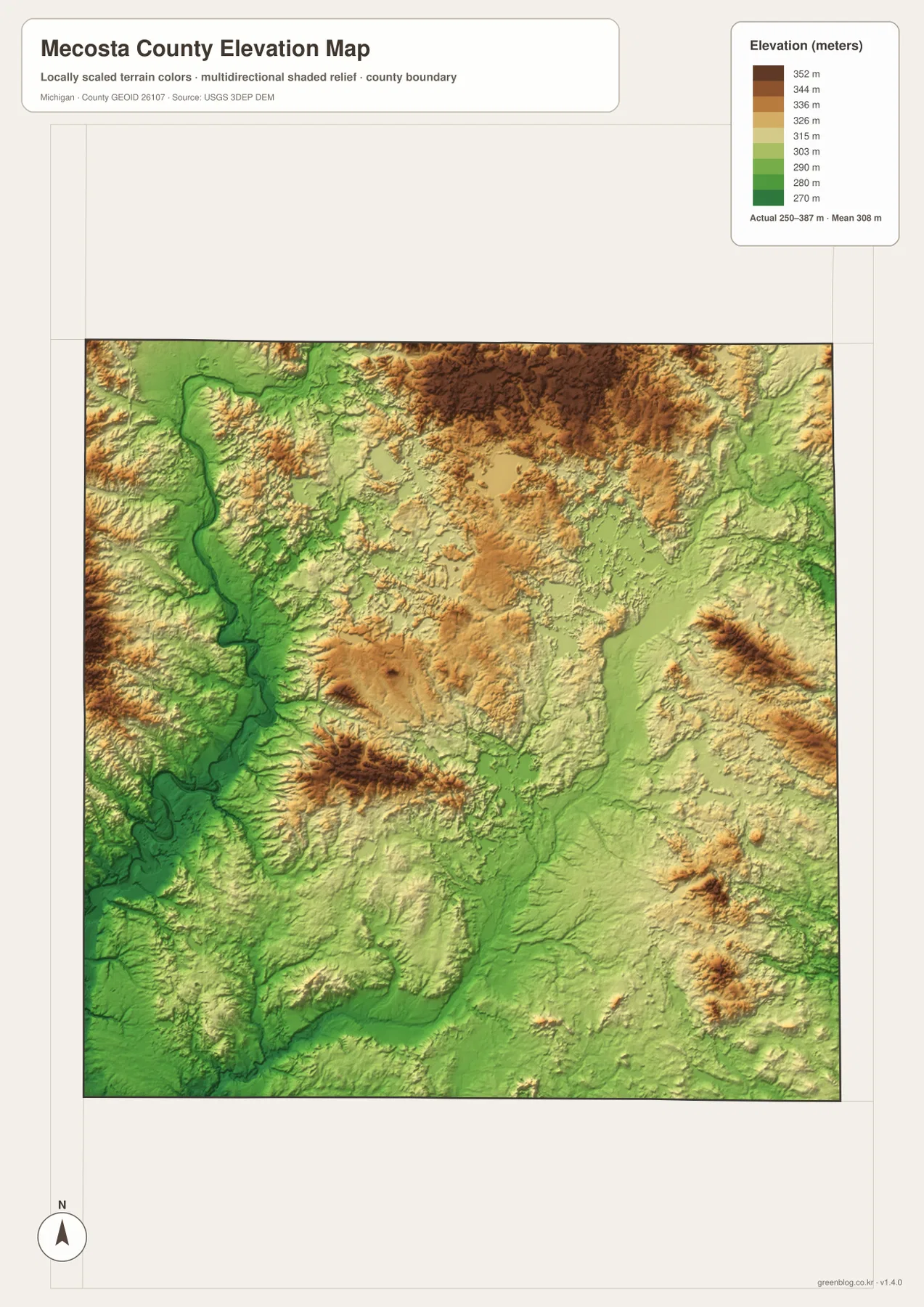
The colors are intended for broad comparison within Mecosta County. A brown area should not automatically be described as mountainous, and a green area alone does not establish flood risk. Exact lot elevations, drainage grades, engineering design, flood protection, and parcel surveys require authoritative source data and professional measurement when appropriate. As an overview, however, the map clearly explains why the Muskegon corridor sits lower than much of the north-central interior and why several streams follow lower bands between hills.
A simple map-reading sequence connects roads, rivers, lakes, and higher ground
A practical first pass begins in Big Rapids. Follow US-131 north toward Paris and south toward Stanwood and Morley, then use M-20 to move east toward Mecosta. From there, add Barryton near the northeastern side and remember Canadian Lakes as the water-rich area farther south. This creates a small set of reliable reference points before the many stream and lake names are introduced.
Next, switch to the terrain-and-water map and find the Muskegon River beside the western settlement corridor. Move into the central lake country around Lake Mecosta and Canadian Lakes, then continue to Chippewa Lake, Martiny Lake, and the Chippewa River system in the north and northeast. The elevation map completes the picture by showing the lower Muskegon valley and the higher north-central interior. Looking at the same places across two or more sheets gives a more complete understanding than expecting one map to answer every question.
The WebP images in the article are optimized for quick browser viewing. The download archive contains four 3638 × 2572 pixel JPG originals with the same content, which makes them better for enlarging labels, preparing A3 prints, or building classroom reference material. The county map is best for roads and communities, the city-connections map for relative spacing, the terrain-and-water map for rivers and lakes, and the elevation map for comparing valleys with higher ground. They are general reference maps and should not replace live navigation, legal parcel records, flood products, marine charts, engineering plans, or survey work.
Frequently Asked Questions
Are the distances from Big Rapids to Stanwood, Mecosta, Morley, and Barryton driving distances?
No. The city-connections map uses straight-line distances of about 8 miles to Stanwood, 13 miles to Mecosta, 14 miles to Morley, and 17 miles to Barryton. Actual driving mileage and travel time depend on the road network and chosen route, so current navigation information should be used for a trip.
Which map is best for the Muskegon River, Canadian Lakes, Chippewa Lake, and Martiny Lake?
The terrain-and-water map is the clearest choice because it emphasizes the Muskegon and Little Muskegon systems, Lake Mecosta and Canadian Lakes, and the northeastern Chippewa Lake, Martiny Lake, and Chippewa River area. It is a geographic reference map rather than a flood, depth, or navigation product.
Can the 250–387 meter elevation range be used for construction or drainage decisions?
No. The elevation map is intended to compare broad areas of lower and higher terrain at county scale. Exact site elevation, drainage grades, flood protection, road engineering, and parcel surveys require authoritative source data and professional measurements when applicable.
Map File Information
The ZIP includes high-resolution JPG originals of the Mecosta County general map, city-connections map, terrain-and-water map, and elevation map. They are useful for closer label inspection, classroom material, and personal reference printing.
- Included Files: Use only the versions confirmed in the article and supplied images
- File Type: Use the confirmed download contents
- Intended Use: Printing, education, presentations, and map-based projects
Related Maps
Sources and references
- Mecosta County official website: official county government and local information.
- Mecosta County Parks: county-specific information about lakes, rivers, streams, parks, and waterfront recreation.
- U.S. Census Bureau TIGER/Line Shapefiles: official geographic reference data for county boundaries and roads.
- USGS National Hydrography: authoritative reference information for rivers, streams, and lakes.
- USGS 3D Elevation Program: authoritative elevation-data reference.
Green Map creates custom-edited map images using open geographic data sources such as geoBoundaries, Natural Earth, OpenStreetMap, and government open data. These maps are edited visual materials, not raw data files, and are provided for education, documents, presentations, and graphic reference.