This DeKalb County Georgia Map page includes a direct ZIP download with four high-resolution A3 JPG maps: county roads and boundaries, major cities, waterways, and elevation. DeKalb sits immediately east of central Atlanta, yet it is not organized around one dominant town; Decatur serves as the county seat while Brookhaven, Chamblee, Doraville, Dunwoody, Tucker, Stone Mountain, Lithonia, and Stonecrest form several distinct urban centers across the county.
The WebP images in the article are optimized for quick on-screen viewing, while the A3 JPG versions preserve more detail for printing, classroom use, presentations, and side-by-side comparison. Together they make it easier to move from DeKalb’s roads and city centers to the creek network and the county’s changing relief without trying to crowd every feature onto one map.
DeKalb is also a place where a simple dot map can hide a great deal of complexity. Part of Atlanta lies inside the county, several large communities are unincorporated, and city limits often run through continuous urban development. Use these maps to understand general location and landscape relationships; parcel ownership, school attendance areas, service districts, and legal municipal boundaries should still be checked against current county or city data.
Table of Contents
Starting with Decatur: boundaries, roads, and neighboring counties
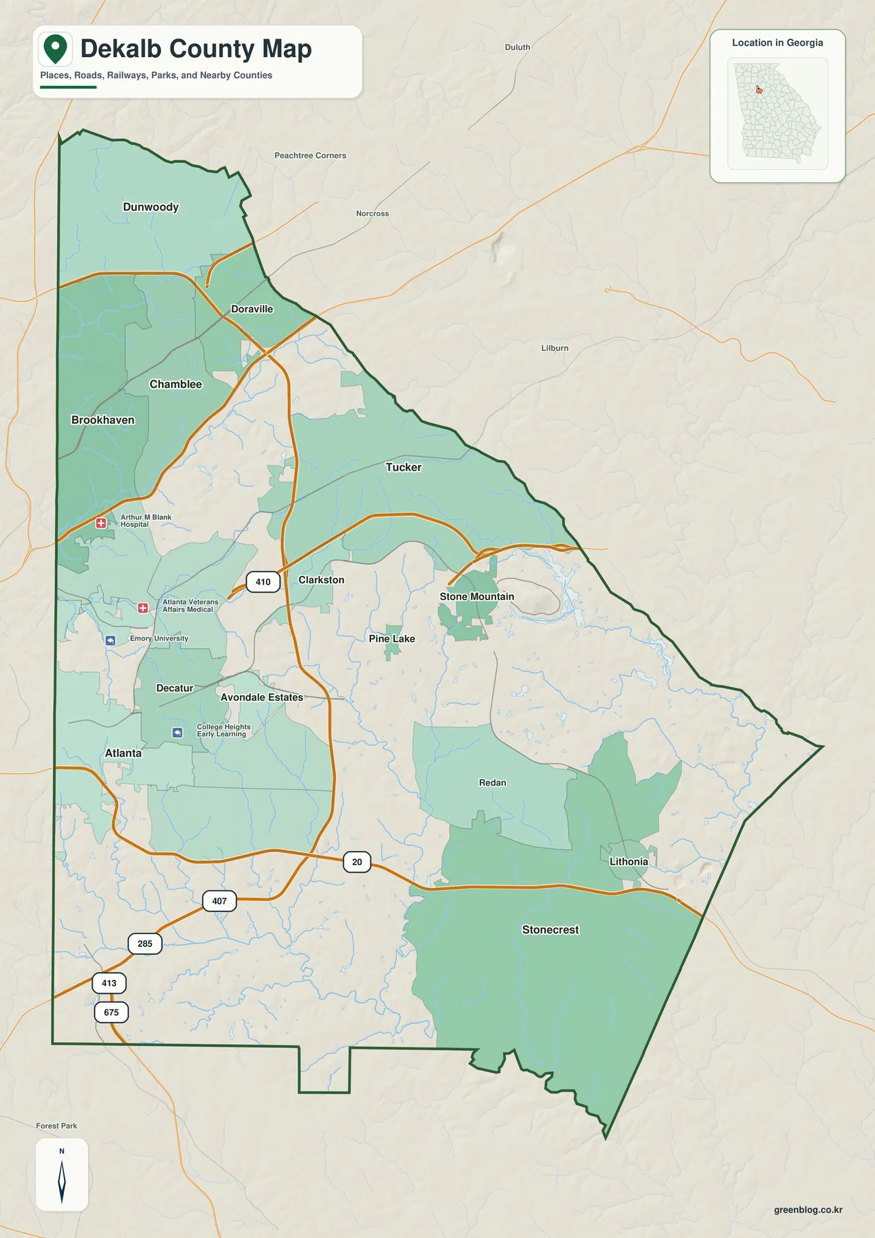
Decatur provides the easiest starting point because it is the county seat and sits near the western side of DeKalb, only a short distance east of downtown Atlanta. From there, the map stretches north toward Brookhaven, Chamblee, Doraville, and Dunwoody; northeast toward Tucker; east toward Stone Mountain; and southeast toward Lithonia and Stonecrest. Atlanta itself appears along the western edge because the city crosses the Fulton–DeKalb county line.
The county borders Fulton to the west, Clayton to the southwest, Henry to the south, Rockdale to the southeast, and Gwinnett to the north and east. Those borders matter for government and records, but the built environment does not stop at them. Neighborhoods, shopping corridors, and road networks continue across county lines, especially near Atlanta and the northern suburbs, so a boundary map is most useful when it is read together with the place names and major transportation routes.
Several transportation corridors help organize the county. The existing county material identifies I-85 with the Brookhaven–Chamblee–Doraville corridor, I-285 as the large arc through northern and eastern DeKalb, and I-20 as the east–west route across the southern half toward Stonecrest and Lithonia. US 78 runs from the Decatur area through Tucker toward Stone Mountain. These roads cut across municipal lines and explain why places that belong to different local governments can still function as one continuous urban area.
The county map also includes selected parks, hospitals, and institutional landmarks, including the Emory University area on the west side. Those reference points are helpful for orientation, but the map is not intended to show every incorporated city, every neighborhood, or every public facility. Large unlabeled areas can contain dense residential and commercial development, so the absence of a label should never be read as evidence of open or undeveloped land.
| State | Georgia |
|---|---|
| County | DeKalb County |
| County seat | Decatur |
| Created | 1822 |
| 2020 population | 764,382 |
| 2025 population estimate | 774,394 |
| 2020 land area | 267.74 square miles |
| FIPS code | 13089 |
The Census figures in the existing source material underline how urban the county is: 764,382 residents were counted in 2020, with a July 1, 2025 estimate of 774,394. The 2020 density was listed at 2,854.9 people per square mile. That population is spread across incorporated cities and large unincorporated communities rather than concentrated in a single county-center city.
Six major city centers across one continuous metro county
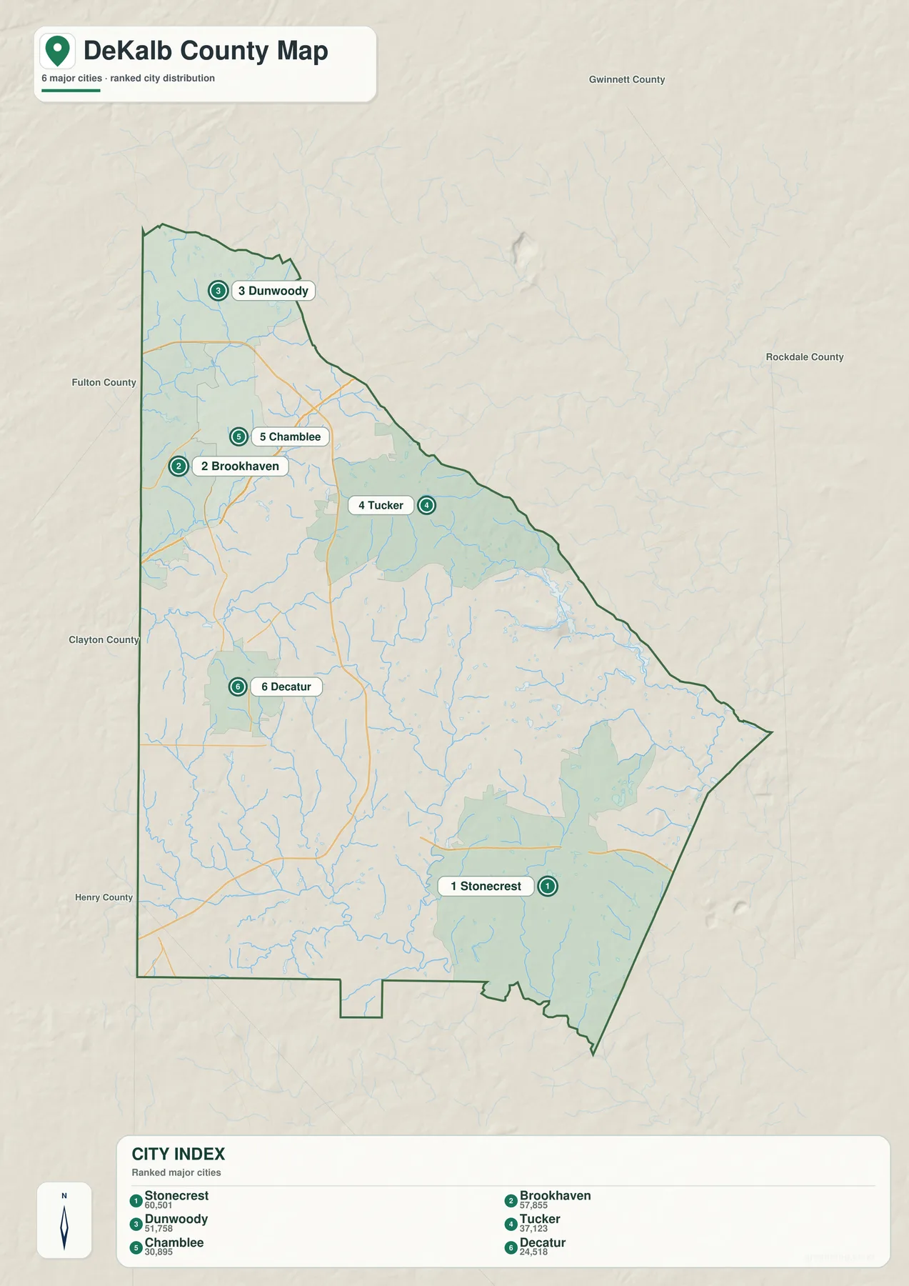
The city map selects six major places—Stonecrest, Brookhaven, Dunwoody, Tucker, Chamblee, and Decatur—to make the county’s multi-center pattern easier to see. Stonecrest anchors the southeast, Decatur the west-central area, Tucker the northeast, and Brookhaven, Chamblee, and Dunwoody the northern side. The spacing is useful precisely because these places do not form a simple line from one county seat to a ring of small towns.
Northern DeKalb is strongly shaped by both highways and MARTA. The source material places Brookhaven, Chamblee, and Doraville along the I-85 and Buford Highway corridor and notes that MARTA’s Gold Line serves the same general sequence of communities. Dunwoody is served by the Red Line. These separate rail branches help explain why northern development clusters around several corridors rather than one downtown.
Decatur has a different role. Its municipal footprint is small, but it contains county government functions and a MARTA Blue Line station. The Blue Line continues through the Avondale and Kensington area toward Indian Creek, creating an east–west transit route that is distinct from the northern Gold and Red branches. On a county-wide map, Decatur therefore works better as an administrative and transit reference point than as a measure of where most DeKalb residents live.
The city selection is not an inventory of every municipality. The existing DeKalb material lists 13 incorporated municipalities: Atlanta in part, Avondale Estates, Brookhaven, Chamblee, Clarkston, Decatur, Doraville, Dunwoody, Lithonia, Pine Lake, Stonecrest, Stone Mountain, and Tucker. Panthersville, Candler-McAfee, Gresham Park, Redan, and other large unincorporated communities add still more populated areas that may not appear as city labels.
This is especially important around Stone Mountain and Lithonia. The City of Stone Mountain is not the same jurisdiction as Stone Mountain Park, even though the names are closely associated. Lithonia is a small incorporated city within a broader southeastern landscape that includes Stonecrest and the Arabia Mountain area. A city point is therefore best read as a locator, not as the outer edge of a complete community or service area.
Creeks and lakes from Peachtree Creek to the South River
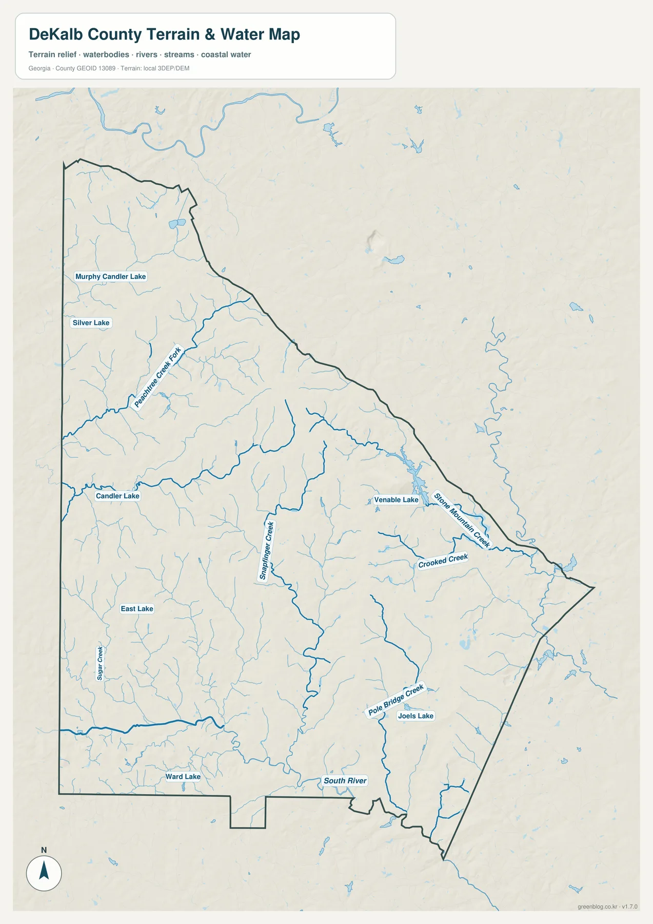
The water map removes much of the transportation emphasis and makes the county’s drainage network much easier to follow. Murphy Candler Lake and Silver Lake appear in the northwest, with Peachtree Creek Fork extending through the northern part of the county. Candler Lake and East Lake provide additional western reference points, while Sugar Creek and a dense web of smaller tributaries cross the urbanized central area.
Snapfinger Creek is one of the most prominent north–south streams on the map. Farther east, Venable Lake sits near the Stone Mountain side of the county, and Stone Mountain Creek and Crooked Creek show how water drains away from the higher eastern landscape. Pole Bridge Creek and Joels Lake appear in the southeast, while Ward Lake and the South River mark the lower southern part of the county.
The existing article explains the larger watershed split in plain terms. Some northern and western creek systems connect toward Peachtree Creek and ultimately the Chattahoochee, while many central and southern tributaries feed the South River. The South River continues southeast through the broader Arabia and Panola Mountain landscape toward the Ocmulgee basin. That divide is easy to miss on a road map but becomes much more obvious when the blue stream network is allowed to dominate the page.
For local study, the water map is useful for comparing neighborhoods, parks, stream corridors, and the direction of drainage. It should not be used as a flood-insurance map, a parcel boundary, a navigation chart, or a statement of real-time water conditions. Flood zones, water levels, storm impacts, and legal water boundaries require current data from the agencies responsible for those subjects.
Elevation from the northern uplands to Stone Mountain and the southern low ground
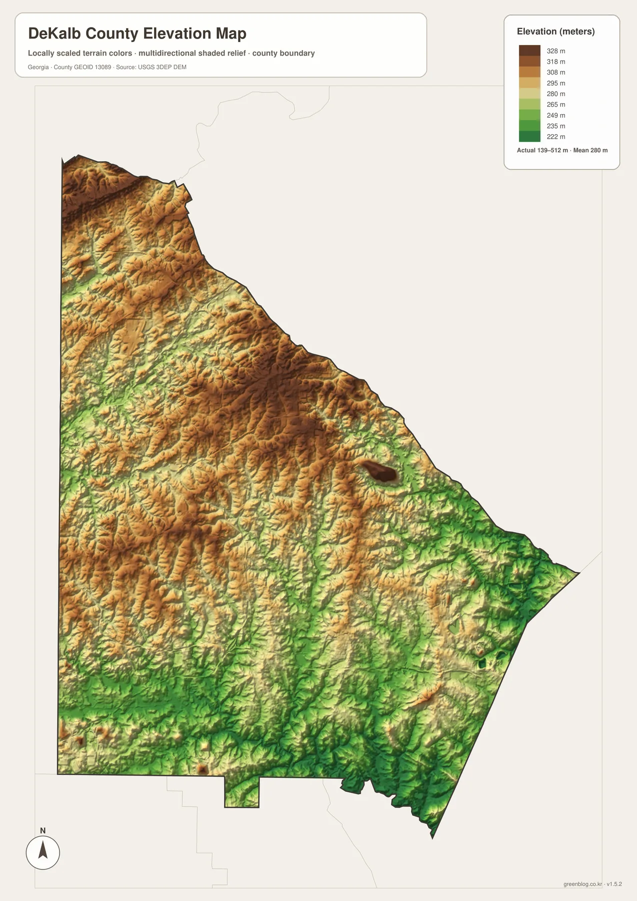
The elevation map changes the county’s appearance again. Its legend reports an underlying elevation range of roughly 139 to 512 meters with a mean near 280 meters, while the displayed colors are locally scaled to make differences within DeKalb easier to see. Brown and tan ridges dominate much of the northwestern and central upland terrain, whereas greener tones become more common toward the south and southeast where the land is generally lower.
Stone Mountain stands out as an isolated high feature in the eastern part of the map. The existing geographic material also describes Stone Mountain and the Arabia Mountain landscape as resistant exposed-rock features rising above the surrounding Piedmont. These rock masses, wooded slopes, and nearby streams create a striking natural contrast with the dense road and neighborhood pattern seen on the county map.
Comparing elevation with the water map helps explain why the stream network bends and branches the way it does. Creeks follow lower ground between ridges, and the South River occupies the broader lower terrain near the southern side. Stone Mountain Creek, Snapfinger Creek, and other tributaries can be interpreted more clearly when their channels are viewed against the shaded relief instead of as blue lines on a flat background.
This surface is generalized for county-wide viewing. It is valuable for understanding relative relief, but it is not a survey-grade elevation model and should not be used to set construction heights, determine property boundaries, or replace engineering measurements. For those tasks, use the original elevation data or a professional survey rather than reading a precise value from the published map.
Frequently Asked Questions
Is part of Atlanta inside DeKalb County?
Yes. Atlanta crosses the Fulton–DeKalb county line, so an Atlanta mailing address does not automatically mean the property is in Fulton County. Check the exact address against current local records whenever county or municipal jurisdiction matters.
Are Stone Mountain city and Stone Mountain Park the same area?
No. The City of Stone Mountain is an incorporated municipality, while Stone Mountain Park covers a separately managed area around the famous granite dome. A city point on the map is useful for orientation, but it does not define the park boundary.
Does the JPG contain different geography from the WebP preview?
No. The downloadable JPGs show the same mapped geography as the WebP previews, but at a larger A3 resolution intended for printing and closer inspection. The format change does not turn them into parcel, zoning, flood-hazard, or survey maps.
Map File Information
DeKalb County Map Files
- Included Files: County map, city map, water map, and elevation map
- File Type: 4 high-resolution A3 JPG files in one ZIP archive
Related Maps
Sources and references
The county location and local-government context were checked against DeKalb County resources, while population and area figures come from the U.S. Census Bureau material included with the source package. MARTA supports the rail discussion, while the National Park Service and DeKalb County’s official bicentennial history provide background for the eastern rock landscape and county history.
- DeKalb County Maps
- U.S. Census Bureau QuickFacts: DeKalb County
- MARTA Stations and Rail Lines
- National Park Service: Arabia Mountain National Heritage Area
- DeKalb County official history: county founded in 1822
Green Map creates custom-edited map images using open geographic data sources such as geoBoundaries, Natural Earth, OpenStreetMap, and government open data. These maps are edited visual materials, not raw data files, and are provided for education, documents, presentations, and graphic reference.