Henry County sits in east-central Indiana, with New Castle providing the clearest road and settlement reference near the middle of the county. You can download the high-resolution JPG ZIP directly from this page when you need larger road labels, stream names, terrain colors, or printable originals. This Henry County Indiana Map page follows the road network from New Castle toward Middletown, Mount Summit, Mooreland, Spiceland, and Knightstown, then connects those places with the Little Blue River, Flatrock River, Big Blue River, Westwood Park Reservoir, and a 270–363 meter elevation range.
New Castle is the simplest place to begin. State Road 3 runs north-south through the city, while State Road 38 crosses it from west to east. U.S. 36 forms another east-west reference in the northern half, and I-70 and U.S. 40 provide two separate routes across the south. That road layout spreads the county’s towns across several corridors instead of placing them in one continuous urban strip.
The terrain map changes the picture substantially. Lower green ground covers much of the west and southwest, while higher yellow and brown terrain becomes much more extensive toward the east and northeast. The Little Blue River and Flatrock River cut deep low corridors through that higher eastern ground. In the southwest, the Big Blue River and Montgomery Creek occupy another low area, and Westwood Park Reservoir provides a distinct water landmark west of New Castle.
Table of Contents
New Castle provides the main road crossroads for Henry County
The general county map is easiest to read from New Castle outward. State Road 3 enters from the north near Mount Summit, runs through New Castle, and continues south toward Spiceland. State Road 38 approaches from the west near the Cadiz side of the county and crosses New Castle before continuing east. The hospital and Henry County Sheriff’s Office labels near the city also make the central area easy to recognize even before individual road numbers are read.
U.S. 36 creates a separate northern corridor. Sulphur Springs lies to the west of Mount Summit, while Mooreland is farther east. Blountsville appears near the northeastern edge with State Road 35 nearby. The northern towns are separated by broad open spaces and a dense network of small streams, so this part of the map has a very different appearance from the larger New Castle area.
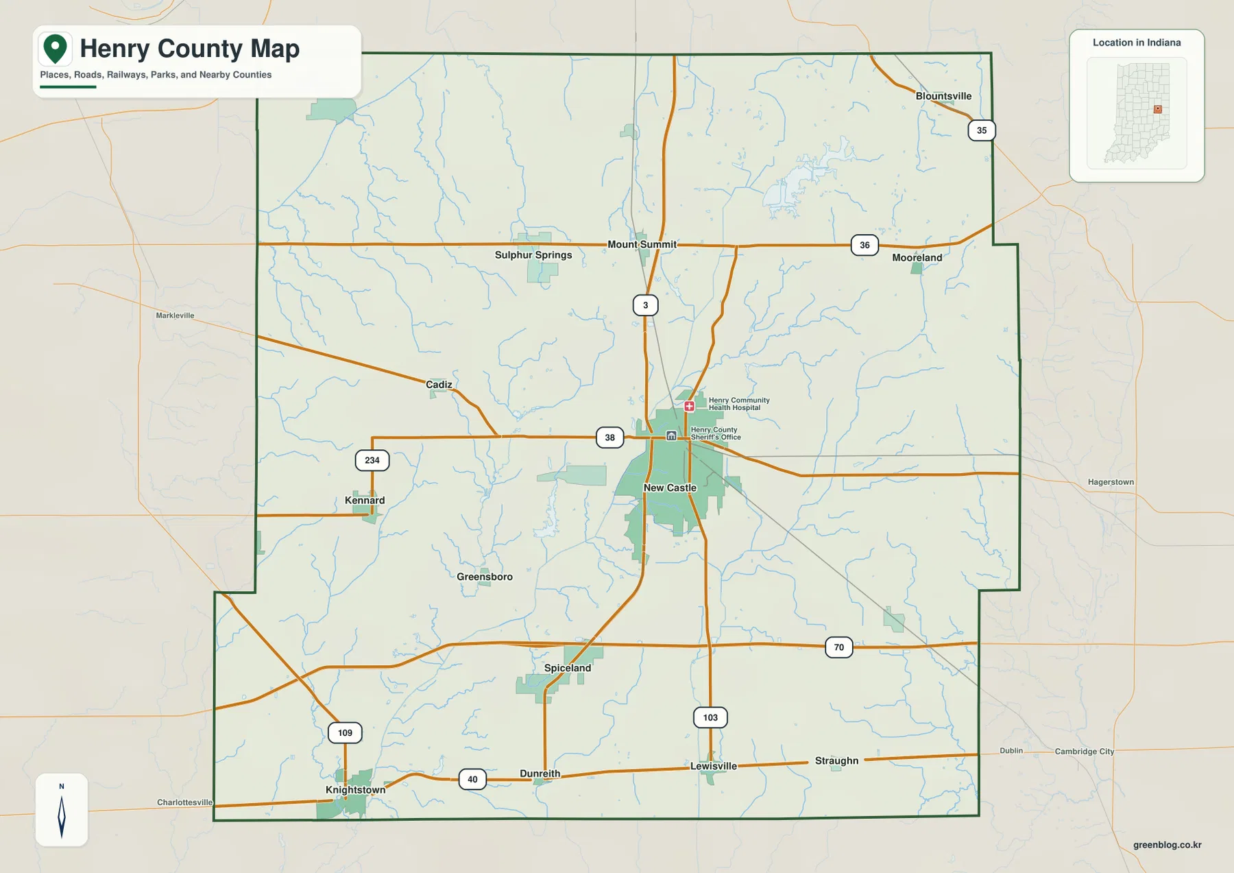
The southern half is organized by two different east-west routes. I-70 crosses north of Spiceland, while U.S. 40 lies farther south near Knightstown, Dunreith, Lewisville, and Straughn. Knightstown is close to the southwestern edge and State Road 109 extends north from that area. State Road 103 is labeled near Lewisville, giving the southeastern portion another useful north-south reference.
West of New Castle, Cadiz and Kennard help break up the large rural area. State Road 234 passes Kennard, while Greensboro is labeled southwest of New Castle. These smaller places matter because the city index does not include every settlement shown on the general map. When a road connection or a small community is the target, the general map is the better source.
A simple orientation method is to remember four bands: U.S. 36 in the north, State Road 38 through New Castle, I-70 in the south-central area, and U.S. 40 along the lower part of the county. State Road 3 then ties several of those bands together from north to south. That framework makes it much easier to place the smaller towns without memorizing every local road.
The city index shows one large central city and five widely separated smaller places
The supplied city index highlights six places with values printed directly on the map. New Castle is first at 17,367. Knightstown follows at 2,241 and Middletown at 2,235, making those two values nearly equal. Spiceland is listed at 840, Mount Summit at 713, and Mooreland at 493. These figures are best treated as the values printed on the supplied map rather than as a guarantee of the latest official population estimates.
| Rank | Place | Value printed on map | Position |
|---|---|---|---|
| 1 | New Castle | 17,367 | Central |
| 2 | Knightstown | 2,241 | Southwest |
| 3 | Middletown | 2,235 | Northwest |
| 4 | Spiceland | 840 | South-central |
| 5 | Mount Summit | 713 | North-central |
| 6 | Mooreland | 493 | Northeast |
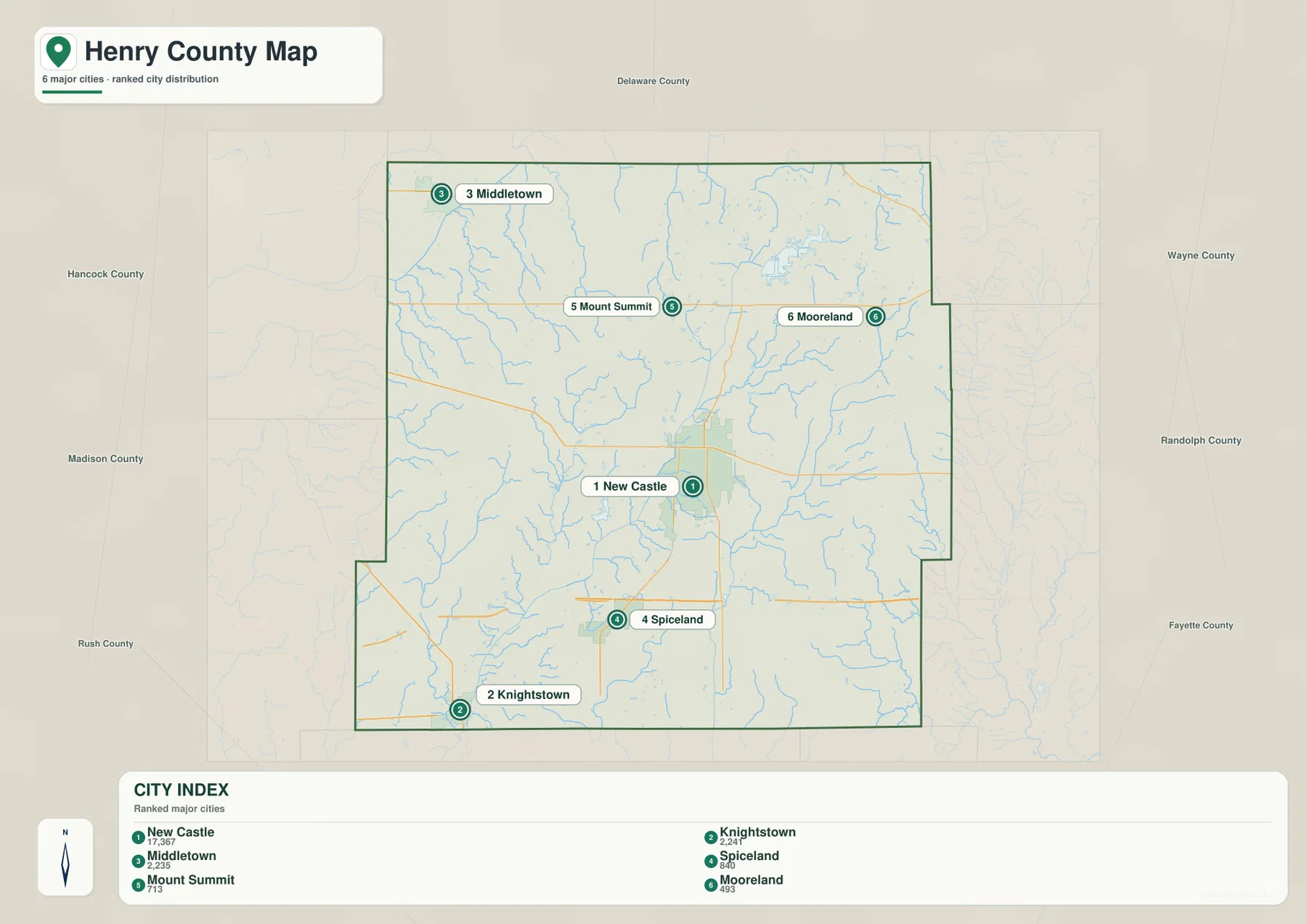
Knightstown and Middletown are useful examples of why the index is about location as well as rank. Their printed values are almost the same, but Knightstown is in the southwest while Middletown is in the northwest. Spiceland lies south of New Castle, Mount Summit lies north, and Mooreland sits farther northeast. The map therefore creates a spoke-like arrangement around New Castle rather than a chain of similarly sized places.
The general map contains additional names such as Sulphur Springs, Cadiz, Kennard, Greensboro, Dunreith, Lewisville, Straughn, and Blountsville. Their absence from the six-place index does not mean they are absent from the county. The index is intentionally selective. Use it for a quick comparison of the highlighted places and return to the general map for smaller communities and road connections.
Henry County’s official comprehensive plan identifies New Castle as the county seat and the county’s most populated municipality in the plan’s demographic discussion. That local context matches the supplied map, where New Castle has the largest developed footprint and sits at the intersection of important roads. It does not mean every activity in the county is centered there, which is why Middletown, Knightstown, and the smaller northern and southern communities remain important map references.
Little Blue and Flatrock define the east, while Big Blue and Westwood Park Reservoir mark the southwest and center
The terrain-and-water map makes the eastern side immediately recognizable. Little Blue River runs through the east and bends among numerous tributaries, while Flatrock River continues southward through another long valley. Stoney Creek is labeled near the northeast. These larger blue lines stand out against a background of smaller channels and are especially useful when the city and road labels are removed.
Westwood Park Reservoir is the clearest named water body near the middle-west of the county. New Castle’s comprehensive planning material describes Westwood Park as being about three miles west of the city and explains that Westwood Lake resulted from flood-control structures associated with the Big Blue River system. On the supplied water map, the reservoir is easy to recognize as a branching water body west of New Castle’s general location.
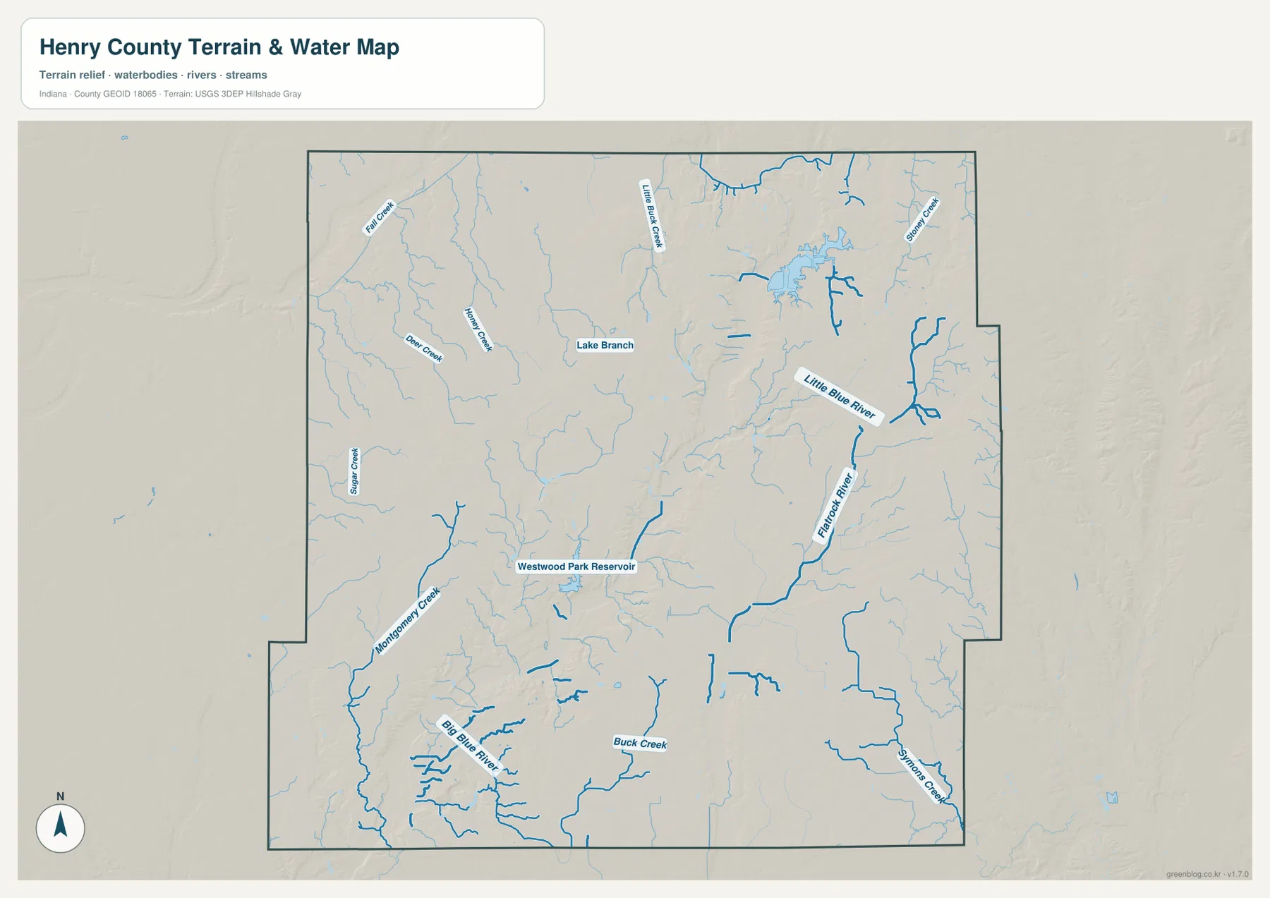
In the southwest, Big Blue River is the strongest stream reference. Montgomery Creek approaches through the western side, and several short tributaries join the broader low area around the river. Buck Creek runs through the south-central portion, while Symons Creek is labeled near the southeast. The Little Blue River and Big Blue River should not be treated as one continuous feature simply because the names are similar; they occupy very different parts of the county.
The western and northwestern parts of the map contain a set of smaller named streams, including Fall Creek, Deer Creek, Honey Creek, and Sugar Creek. Little Buck Creek appears farther north near the center, and Lake Branch is also labeled. Rather than memorizing every name, it is easier to divide the map into the eastern Little Blue–Flatrock valleys, the southwestern Big Blue River area, the Westwood Park Reservoir landmark, and the smaller western creek network.
This water map is intended for geographic reference, not for flood-zone, legal-boundary, navigation, water-quality, or property decisions. A blue line does not tell you current water level or flood probability. Those questions require current agency data. Here, the map is most useful for understanding where the major river valleys and reservoir sit relative to New Castle and the rest of Henry County.
The 270–363 m surface rises toward the east and northeast, with deep river valleys cutting through the high ground
The elevation legend gives an actual Henry County range of about 270 to 363 meters and a mean of 321 meters. Greens represent lower terrain, while yellow, tan, and brown show higher ground. The broadest low areas are in the west and southwest. Moving eastward, the colors become warmer and higher, with extensive brown terrain near the eastern and northeastern edge.
The eastern high ground is interrupted by the Little Blue River and Flatrock River valleys. Their channels appear as long green corridors cut into yellow and brown terrain. This is one of the clearest examples of why the water and elevation maps work well together: once the river names are known, the low shapes on the relief surface become easy to identify. The east is therefore high overall, but it is not a single unbroken upland.
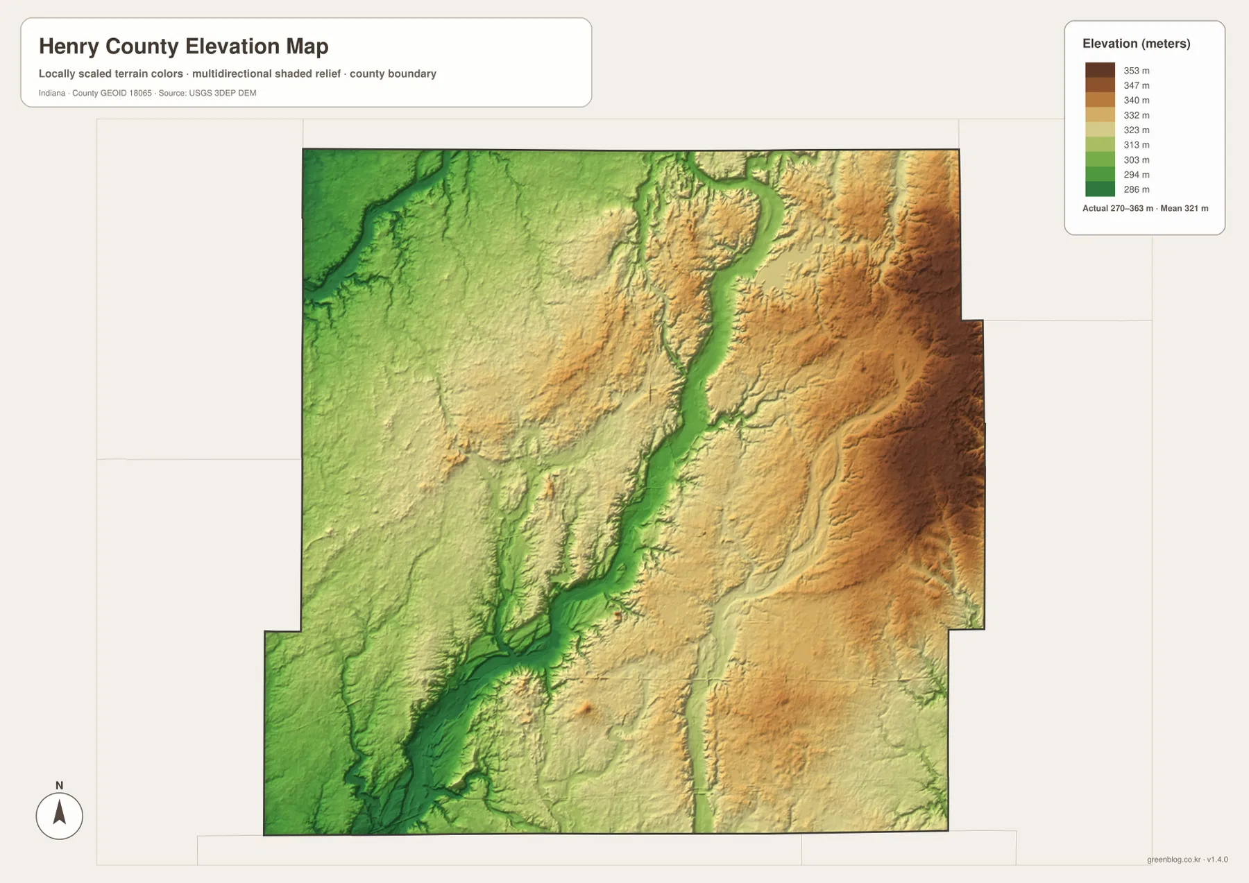
The southwest also contains a broad low zone around the Big Blue River and Montgomery Creek. Green terrain extends toward the southern edge, with surrounding land gradually rising into lighter green and yellow. Westwood Park Reservoir lies within the lower central-western part of the county. These low areas explain why the western side appears much greener on the elevation map than the eastern boundary.
The northwest is more moderate. Fall Creek and Deer Creek occupy lower channels, but the land between them rises into gentle higher areas. Farther north and east, the surface becomes progressively higher before the Little Blue valley cuts through it. Henry County is therefore not just a simple eastward slope; a broad west-to-east rise is crossed by several distinct stream valleys.
The 270–363 m range is a county-scale reference, not a survey measurement for a property or construction site. Building elevations, road grades, drainage design, and parcel-level work require source elevation data or professional surveying. The USGS 3D Elevation Program is a better starting point for precise terrain information. The supplied map is designed for broad comparison of higher ground, lower valleys, and the overall relief difference across the county.
Choose the general map for roads, the water map for valleys, and the elevation view for the east–west contrast
For first-time orientation, start with the general map. Find New Castle and the State Road 3–38 crossing, then use U.S. 36 in the north and I-70 and U.S. 40 in the south to place Middletown, Mount Summit, Mooreland, Spiceland, and Knightstown. Smaller places such as Kennard, Dunreith, and Lewisville are also easier to find on this view.
Use the city index when the main question is how the six highlighted places compare. New Castle is clearly dominant in the printed values, Knightstown and Middletown are nearly tied but lie in different directions, and the remaining three places occupy smaller northern and southern positions. Current population analysis should use the latest official statistics rather than assuming the map index is current.
For physical geography, locate Little Blue River and Flatrock River in the east, then compare the Big Blue River and Westwood Park Reservoir farther west. Open the elevation map beside the water map and look for the same channels as green lowlands. That comparison makes the higher eastern terrain and lower western-southwestern ground much easier to understand.
The web previews are optimized for quick page viewing. Small creek labels, road numbers, and fine elevation changes are easier to see in the original files. The download archive contains the county/general map, city index map, terrain-and-water map, and elevation map as 3638×2572-pixel JPG originals. Download the ZIP when you want to zoom farther, print the maps, or compare the originals side by side.
A useful comparison method is to follow the same place through several views. Find New Castle on the road map, switch to the water map to locate Flatrock River to the east and Westwood Park Reservoir to the west, and then compare those areas on the elevation surface. Around Knightstown, the Big Blue River system becomes more relevant; around Mooreland, the Little Blue River valley and higher eastern terrain are the better references. Repeating that process connects roads, settlements, water, and relief without expecting one map to show everything.
Frequently Asked Questions
What is the easiest way to find New Castle on the map?
Look for the central area where State Road 3 and State Road 38 meet. State Road 3 runs from the Mount Summit side south through New Castle toward Spiceland, while State Road 38 crosses from west to east. The hospital and Henry County Sheriff’s Office labels near New Castle provide additional visual reference points.
Are Little Blue River and Big Blue River in the same part of Henry County?
No. Little Blue River is on the eastern side of the county and lies near the Flatrock River system, while Big Blue River is in the southwest. Their similar names can be confusing, but the supplied water map places them in clearly different areas. The elevation map also shows both as lower valleys within different parts of the county.
Can the 270–363 m elevation range be used as the exact elevation of a property?
No. The supplied map gives a county-wide range of about 270 to 363 meters, with a mean of 321 meters. It is intended to compare broad higher and lower areas, including the eastern high ground and the river valleys. Exact property, construction, drainage, or engineering elevations require source elevation data or professional survey work.
Map File Information
This ZIP contains the Henry County general map, city index map, terrain-and-water map, and elevation map as high-resolution JPG originals for enlarged viewing and printing.
- File Type: ZIP containing four 3638×2572px JPG files
Related Maps
Sources and References
The article is based primarily on the supplied Henry County map set and asset manifest. The following official sources provide local context and underlying boundary, hydrography, and elevation references.
- Henry County Comprehensive Plan – local county and New Castle context
- City of New Castle Comprehensive Plan – local context for Westwood Park and Westwood Lake
- U.S. Census Bureau TIGER/Line Shapefiles – boundary and geographic reference data
- USGS National Hydrography – hydrography reference data
- USGS 3D Elevation Program – elevation source data
Green Map creates custom-edited map images using open geographic data sources such as geoBoundaries, Natural Earth, OpenStreetMap, and government open data.
These maps are edited visual materials, not raw data files, and are provided for education, documents, presentations, and graphic reference.