The downloadable files on this page give Decatur County, Tennessee in four A3-ready JPG views: a county-and-roads map, a ranked city map, a terrain-and-water map, and an elevation map. The ZIP is useful when you need a clean printable reference rather than a single web image. On the maps themselves, Parsons and Decaturville are the easiest places to use as starting points, while the Tennessee River and Kentucky Lake form the long eastern edge that gives the county much of its distinctive shape.
Decatur County lies in West Tennessee. Decaturville is the county seat, but the supplied city index ranks Parsons first and Decaturville second, so the county’s administrative center is not the same as its largest labeled city. The 2020 census counted 11,435 residents, and the Census Bureau’s July 2025 estimate is 11,820. Those countywide figures are useful background, but the maps are more helpful for seeing where the named communities, road approaches, river valleys, and higher ridges actually sit.
The geography is not difficult to recognize once a few anchors are fixed. I-40 touches the northern part of the county, US 412 crosses the Parsons area, SR 69 runs through the middle toward the south, and US 641 appears in the lower part of the map. The eastern boundary, by contrast, is anything but straight: it follows the Tennessee River and the Kentucky Lake reach, with numerous creek valleys entering from the interior.
Table of Contents
Parsons and Decaturville divide the county into two useful reference areas
Parsons sits north of Decaturville and is the more prominent urban label on the supplied county map. Several routes meet or pass near Parsons, including US 412, which runs west to east across this part of the county. Decaturville lies farther south and serves as the county seat. SR 69 continues through the central portion of the county, while US 641 is visible farther south. Reading those roads from the two cities outward is a much clearer way to understand the map than treating the county as one undifferentiated rural block.
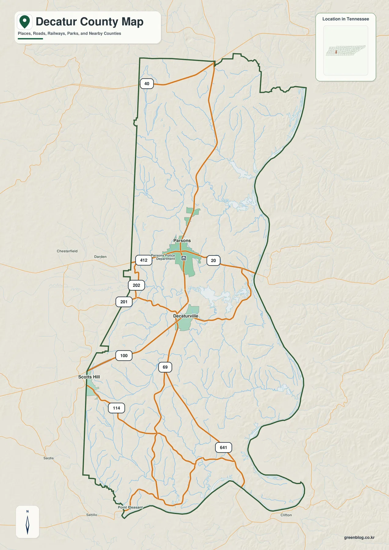
The basic map also makes the county’s north-south proportions easy to see. Parsons is near the middle of the upper half, Decaturville occupies the central-lower area, and Scotts Hill appears near the southwestern edge as a useful boundary reference. Point Pleasant is labeled close to the southern tip. Because roads continue across county lines, labels near the outline should be read with the green county boundary rather than assumed to belong to Decatur County simply because they are visually close.
The northern approach is different from the central and southern approaches. I-40 crosses the upper part of the map, but much of the local road pattern that ties the county together is farther south around Parsons and Decaturville. This distinction matters for readers who are comparing a regional highway route with roads that actually connect the county’s principal communities.
The ranked city map shows why Parsons and Decaturville should not be treated as equivalent labels
The city map deliberately strips away many smaller labels and ranks just two major cities. Parsons is listed first with 2,686, and Decaturville is listed second with 934. The ranking makes the relative urban scale immediately visible, while the county-seat role still belongs to Decaturville. For a reader marking government location, population concentration, or a route between the two, that difference is more informative than a crowded city list.
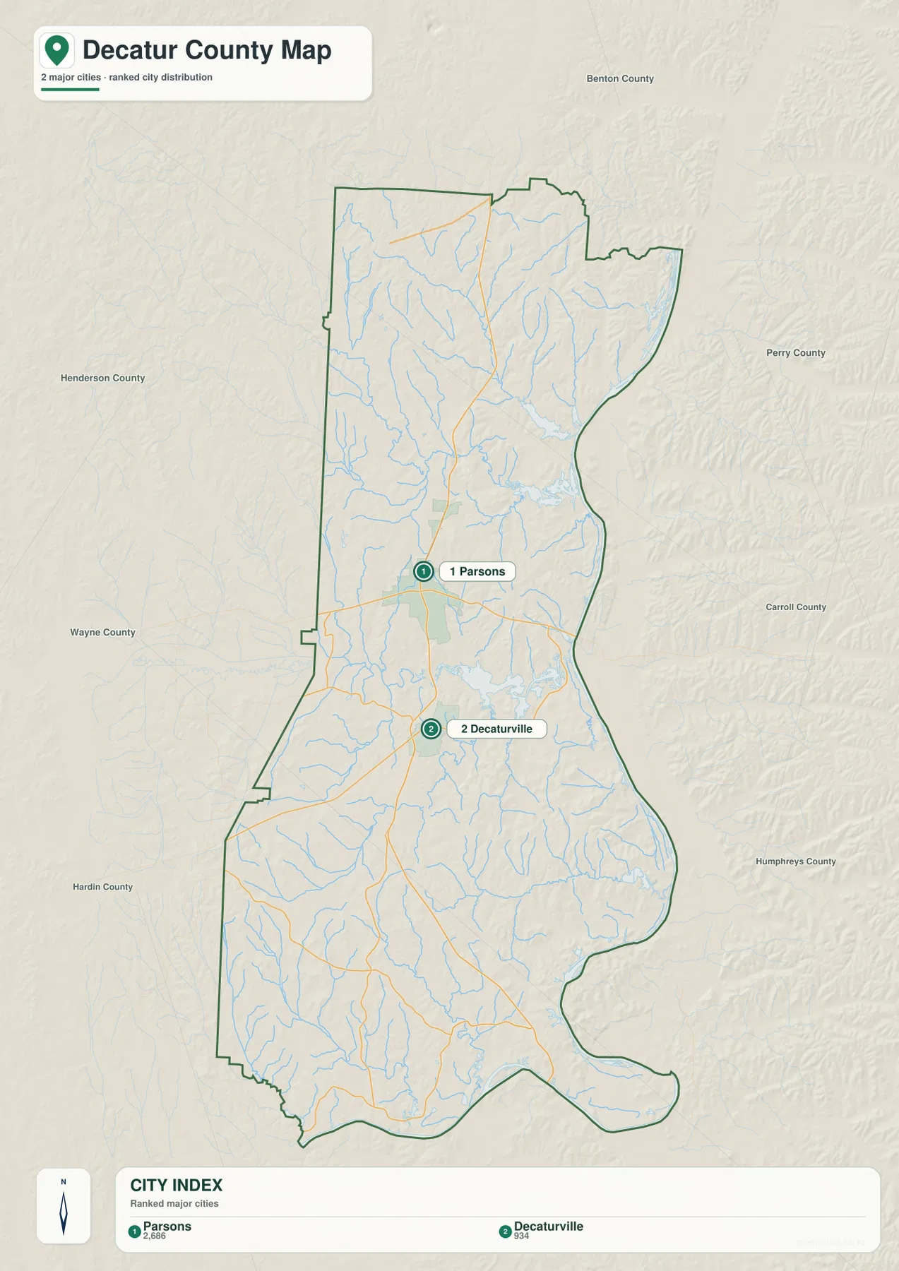
The surrounding county names provide another layer of orientation without requiring a regional atlas. Benton County is labeled beyond the north, Henderson and Wayne Counties appear to the west, Perry and Carroll Counties are shown to the east, and Hardin County lies toward the southwest. Humphreys County is also labeled beyond the lower eastern side. These names help place the long Decatur County outline within West Tennessee, but the city map is still primarily a location-and-ranking graphic rather than a detailed boundary or street map.
The Tennessee River and Kentucky Lake create a river-shaped eastern boundary
The terrain-and-water map is the strongest visual explanation of Decatur County’s eastern edge. The Tennessee River follows the county from the northeast toward the southeast, and the lower reach is labeled Kentucky Lake. Instead of a simple straight boundary, the county line bends with the water, widening and narrowing around river reaches and reservoir inlets. That shape is one of the most recognizable geographic features in the entire map set.
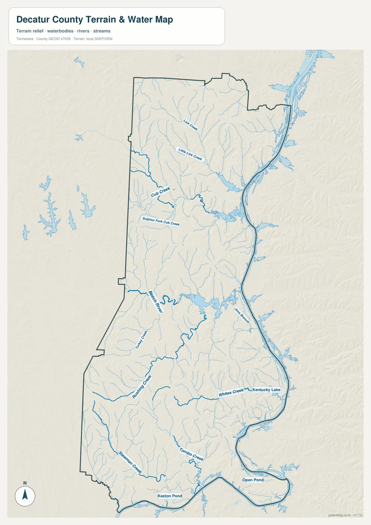
The interior has far more named watercourses than a quick look at the county outline might suggest. Lick Creek and Little Lick Creek are labeled in the north. Cub Creek and Sulphur Fork Cub Creek cross the upper-middle part of the county, while Beech River is a major reference farther south. Rushing Creek, Whites Creek, Turmo Creek, and Stormmen Creek appear across the lower half. The pattern is not a single broad river valley; it is a series of smaller drainage valleys feeding toward the Tennessee River system.
Several smaller water bodies also stand out. Keeton Pond and Open Pond are labeled near the southern edge, and reservoir-like water surfaces appear along parts of Beech River and the eastern river system. These features are useful for explaining why two points that look close in a straight line may have a less direct road connection. A road must use an available bridge or pass around a water arm, so the water map adds practical context that the city map intentionally leaves out.
This map should be used as a county-scale water reference, not as a boating or flood product. It shows the relative position of rivers, creeks, ponds, and the reservoir edge, but it does not provide channel depth, navigation markers, flood stages, property boundaries, or current shoreline conditions. Those questions require current information from the appropriate river, reservoir, county, or federal agency.
Low river valleys and short interior ridges give the county a rolling surface
The elevation map places Decatur County between about 89 and 214 meters, with a mapped mean of roughly 143 meters. The lower elevations appear in green, especially along the Tennessee River corridor and several larger interior valleys. Higher ground is shown in tan and brown on the ridges between those valleys. The range is modest compared with East Tennessee mountain counties, yet the shaded relief makes clear that Decatur County is not uniformly flat.
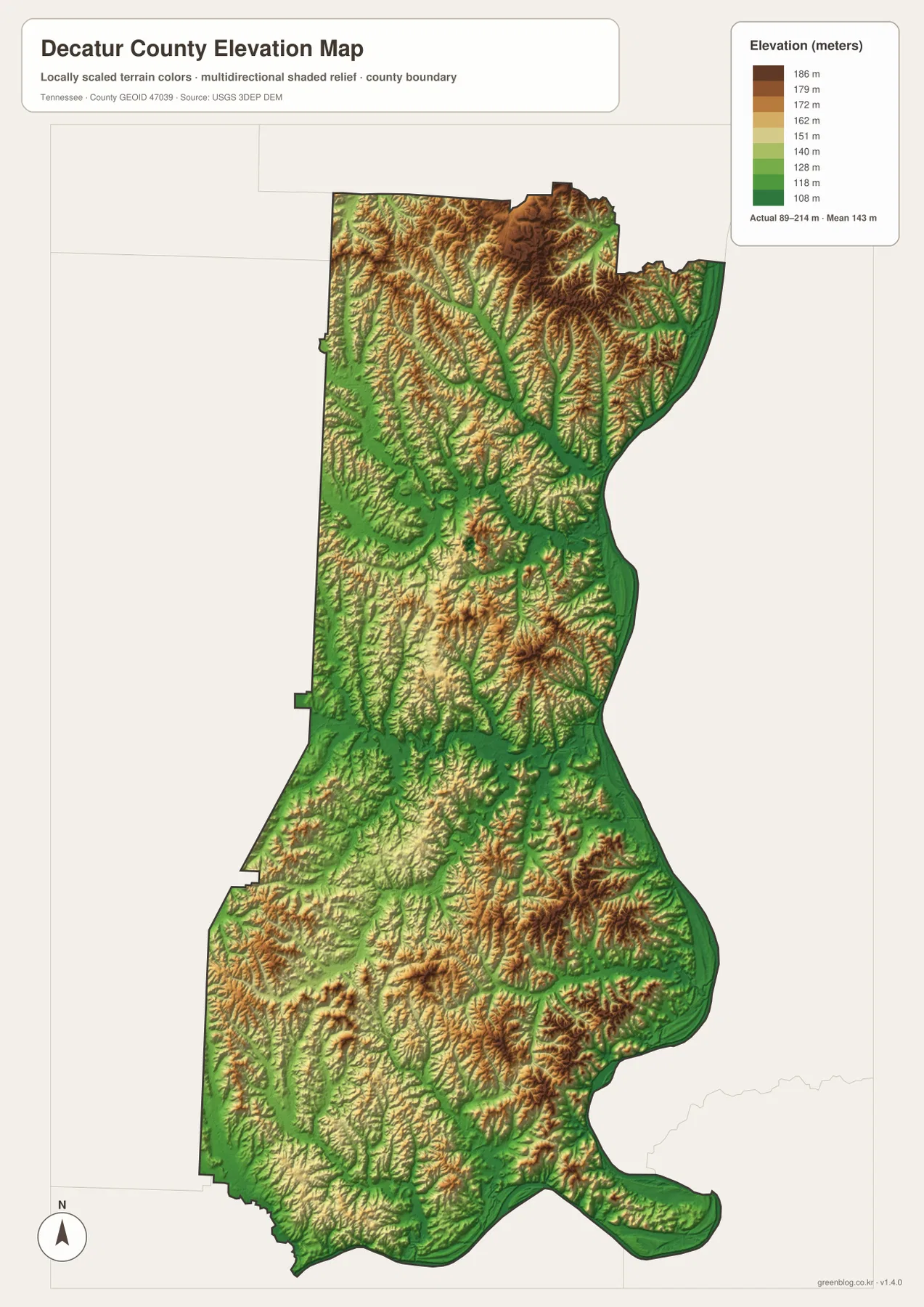
The eastern edge is consistently low where it follows the Tennessee River and Kentucky Lake. Moving west from the river, the terrain rises through many short ridges before dropping again into tributary valleys. Similar relief is visible in the northern half, where narrow green valleys cut through higher ground. In the southern half, broad lower corridors are mixed with isolated higher ridges rather than forming one continuous plateau.
That elevation pattern helps explain the stream density visible on the water map. Creeks occupy the lower cuts between ridges, and roads often follow or cross those same valleys. The relationship is useful for classroom geography, map annotation, and regional comparison because it connects a road line to a visible landform instead of treating transportation and terrain as separate subjects.
The elevation image is generalized for county-scale comparison. It is not a survey, engineering contour map, parcel elevation certificate, or site-specific slope analysis. For a building site, bridge, floodplain, or other precise use, readers should consult the original elevation data and the agency responsible for the specific project.
Roads make more sense when the creek network is visible beside them
US 412 gives Parsons a strong east-west connection, while SR 69 provides a north-south reference through the central part of the county. US 641 appears in the south, and the county map also labels routes 100, 114, 201, 202, and 20 in different sections. Taken together, they show that travel is organized around several corridors rather than a single highway running the full length of the county.
Water explains many of the bends and crossings in that road network. Cub Creek and its forks cut through the north-central area, Beech River divides parts of the middle and south, and the Tennessee River limits eastward crossings to the places where a bridge or connecting route exists. The printed maps are therefore useful for comparing route direction with the physical landscape, even though they do not replace current turn-by-turn navigation or road-condition information.
Census Gazetteer figures list about 333.9 square miles of land and 11.0 square miles of water in Decatur County. The water share is not enormous as a percentage of total county area, but its geographic placement matters: a long river boundary can shape access much more than the percentage alone suggests. The maps make that distinction visible by showing where the water actually lies.
Choose the map view that matches the question you are trying to answer
For a broad county reference, the roads-and-boundary map is the best starting point because it combines communities, major routes, streams, and the county outline. The ranked city view is better when the question is simply where Parsons and Decaturville sit in relation to one another. The terrain-and-water map is the clearest choice for named creeks and the Tennessee River system, while the elevation image is useful when the difference between river bottoms and higher ridges is the subject.
The A3 JPG files can be used for classroom handouts, presentations, local-history notes, route sketches, or a clean base image for editorial work. Keeping the four topics separate also prevents the page from becoming visually overloaded. For current closures, precise property lines, legal boundaries, emergency routing, or field navigation, pair the static map with the responsible county, state, or federal source.
Frequently Asked Questions
Is Parsons or Decaturville the county seat?
Decaturville is the county seat. Parsons is ranked as the larger city on the supplied city map, but population size and county-government status are different things. Use Decaturville as the administrative reference and Parsons as the stronger northern urban and road reference when reading the map.
Where are the Tennessee River and Kentucky Lake in Decatur County?
They follow the eastern side of the county. The Tennessee River descends along the boundary, and the lower portion of the supplied water map is labeled Kentucky Lake. Beech River and many smaller creeks drain from the interior toward this larger river-and-reservoir system.
How much elevation difference does the county map show?
The supplied elevation map shows an actual range of about 89 to 214 meters and a mean near 143 meters. The river and major valleys are generally lower, while short ridges across the interior rise above them. The map is intended for county-scale comparison rather than site-level surveying or engineering.
Map File Information
The ZIP contains the four high-resolution JPG maps shown on this page for Decatur County.
- Included Files: 4 high-resolution A3-ready JPG map files shown in this article
- File Type: JPG files in a ZIP archive
- Intended Use: Printing, education, presentations, and map-based projects
Related Maps
Sources and References
County boundaries and place references can be checked with the U.S. Census Bureau TIGER/Line program, while population and county statistics are available through U.S. Census Bureau QuickFacts. Road context is available in the Tennessee Department of Transportation Decatur County map, and county-history background is available from the Tennessee State Library and Archives.
For the underlying water and elevation context, see USGS National Hydrography and the USGS 3D Elevation Program. These authoritative sources are appropriate when a question requires more current or more detailed information than a static county reference map can provide.
Green Map creates custom-edited map images using open geographic data sources such as geoBoundaries, Natural Earth, OpenStreetMap, and government open data. These maps are edited visual materials, not raw data files, and are provided for education, documents, presentations, and graphic reference.