Pulaski County sits at the center of Arkansas, but its maps do not look like a simple capital-city page. Little Rock and North Little Rock face each other across the Arkansas River, a dense road network spreads through the middle of the county, and the developed area continues northeast through Sherwood and Jacksonville and west toward Maumelle. Beyond that urban core, the landscape changes quickly. Ridges and narrow valleys are much more obvious in the west, while broad lower ground follows the river toward the east and southeast.
The maps on this page make those contrasts easy to compare. You can locate the county boundary and major highways, see the relative positions of six principal cities, follow the Arkansas, Maumelle, and Little Maumelle rivers, and compare a mapped elevation range of roughly 48 to 325 meters. After reviewing the WebP previews, you can download the original high-resolution A3 JPG map files together in one ZIP archive for printing, lessons, reports, or presentations.
Pulaski County’s official government overview identifies Little Rock as the county seat and notes that the county was established in 1818. It also describes the county as a meeting place of three Arkansas natural divisions. That broad transition is visible even without technical terminology: the western side is hillier, the Arkansas River occupies a low central corridor, and the eastern and southern portions contain much more subdued terrain. The maps are therefore useful both for metropolitan orientation and for understanding why the county looks so different from one side to the other.
Table of Contents
Start with the river between Little Rock and North Little Rock
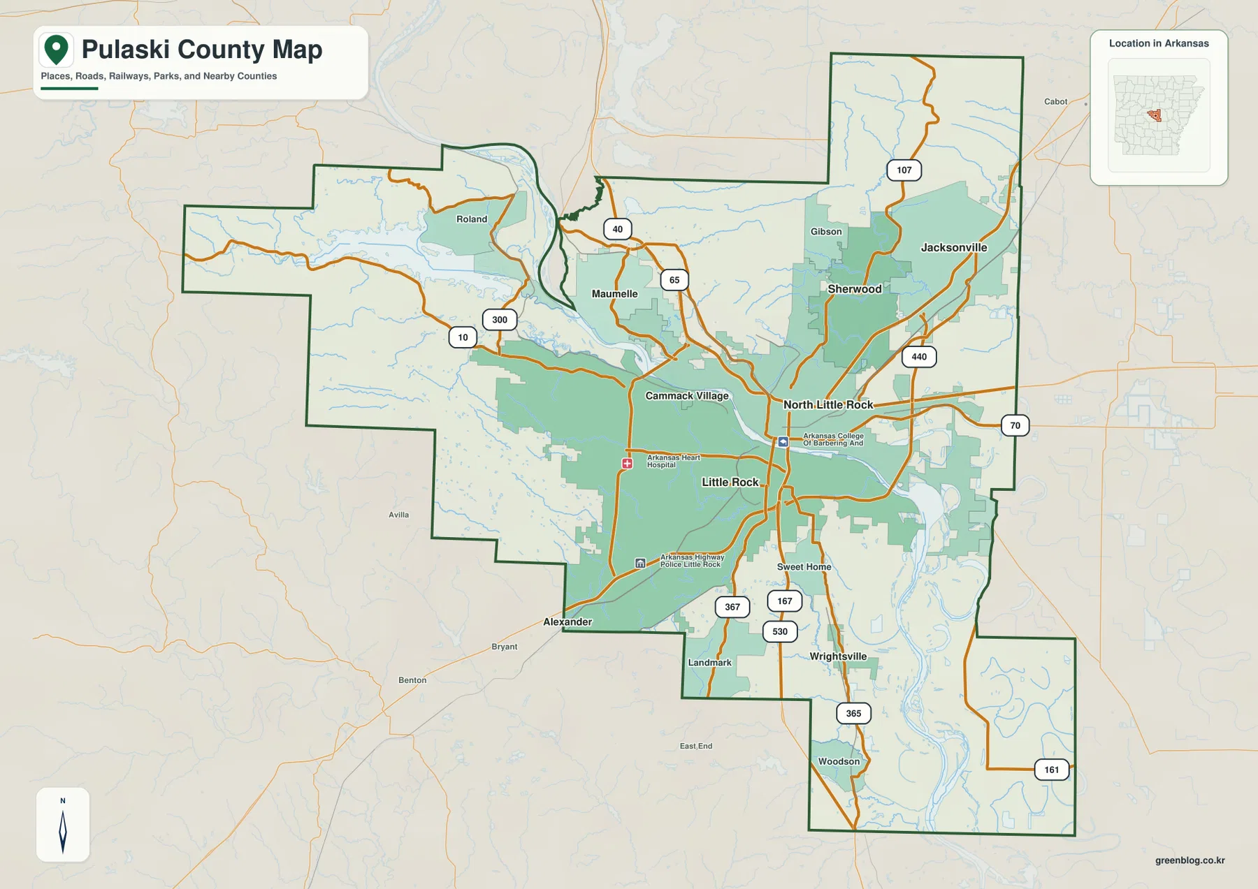
The Arkansas River is the clearest organizing feature on the county map. Little Rock lies on the south side of the river, while North Little Rock occupies the opposite side just to the north and east. Several major roads cross or approach the river in this central area, so the two cities appear as parts of the same metropolitan core even though the waterway remains a strong geographic divider. Cammack Village is tucked into the Little Rock side of the urban area, while Sweet Home and Wrightsville extend the mapped settlement pattern farther south.
North of the river, Sherwood and Jacksonville form a second obvious cluster. Highway 107 runs toward Jacksonville, I-40 passes through the North Little Rock area, and I-440 curves around the eastern side of the urban core. U.S. 70 continues east, while routes 167, 367, and 365 help connect the southern part of the county. To the west, Highway 10 and Highway 300 lead away from the densest urban development into the county’s long western extension. The general map is especially useful because it lets the road network and the irregular county boundary be read together.
The boundary itself deserves attention. Pulaski County stretches far to the west in a narrow arm, rises northward in a large northeastern section, and steps southward below the Little Rock area toward Wrightsville and Woodson. Nearby labels place Saline and Perry counties to the west, Faulkner County to the north, Lonoke County to the east, and Grant and Jefferson counties to the south. Those surrounding references help prevent a common mistake: treating the Little Rock built-up area as if it were the entire county.
The city pattern reaches northeast to Jacksonville and west to Maumelle
The city map removes much of the road detail and focuses on six ranked places: Little Rock, North Little Rock, Sherwood, Jacksonville, Maumelle, and Wrightsville. Little Rock is the largest center shown, and North Little Rock sits immediately across the river. Sherwood and Jacksonville then continue the settlement pattern to the northeast. Maumelle is separated from that line of cities and lies northwest of the core near the Arkansas River, while Wrightsville marks the southern end of the ranked set.
This arrangement is more informative than a list of city populations. It shows that Pulaski County is not built around a single compact center with empty land in every direction. Instead, the most developed places occupy several corridors around the river and road system. Little Rock and North Little Rock form the central pair, Sherwood and Jacksonville extend the urban area northeastward, and Maumelle provides a western suburban reference. Wrightsville sits well south of the other five, where the surrounding map begins to look less urban and more open.
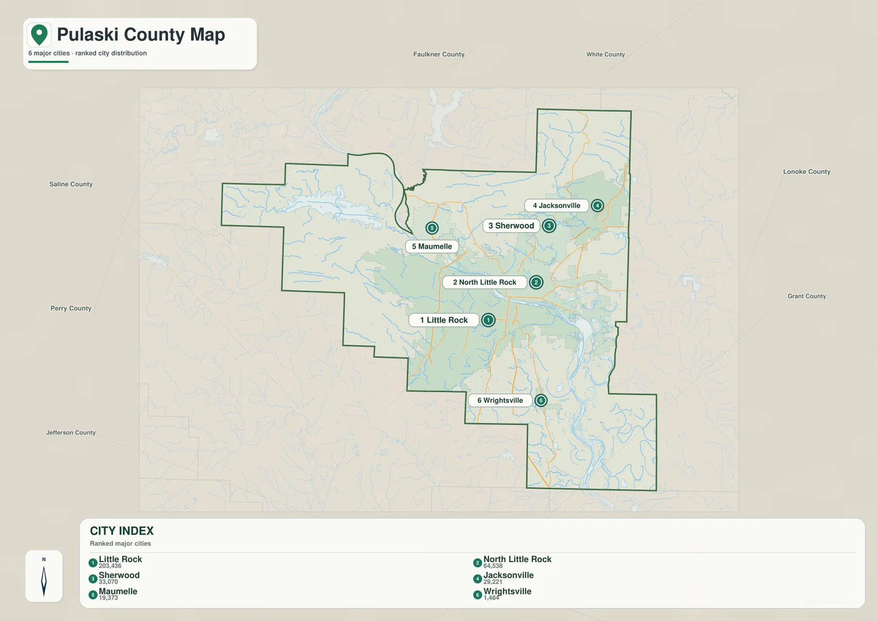
The city view is best used for relative placement rather than navigation. It makes the northeast-to-southwest spread of the major communities very easy to see, but it does not replace a current street map or driving directions. Pairing it with the general county map works well: use the city map to understand where the communities sit, then return to the road map to see which numbered routes connect them.
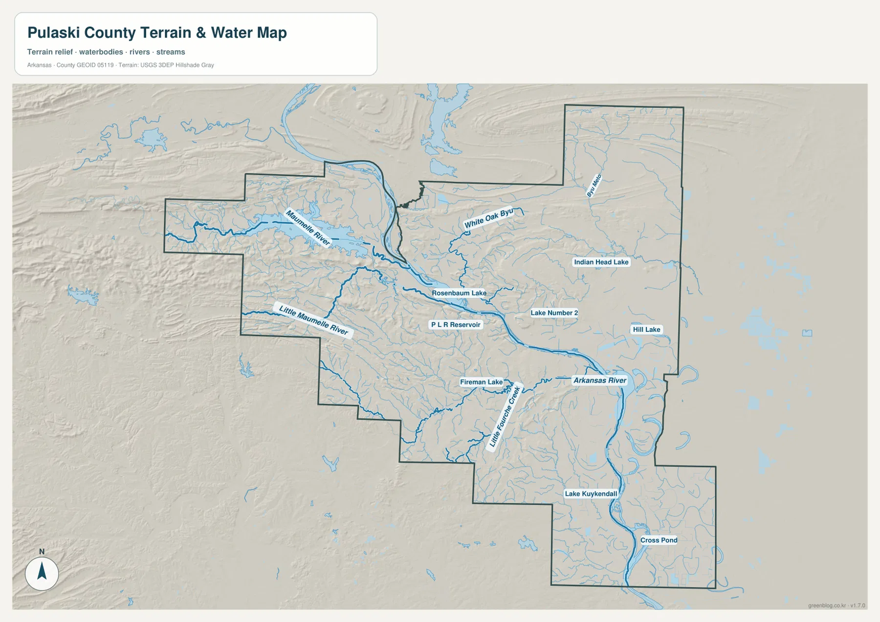
The water map reveals a network much broader than the Arkansas River
The Arkansas River dominates the center of the terrain-and-water map, entering from the northwest, passing through the Little Rock metropolitan area, and bending toward the southeast. Yet the smaller waterways explain much of the county’s shape outside the downtown core. The Maumelle River approaches from the west, and the Little Maumelle River crosses the southwestern interior. White Oak Bayou appears north of the central river corridor, while Little Fourche Creek drains part of the area south and west of Little Rock.
Several smaller water bodies provide additional reference points. Rosenbaum Lake and P L R Reservoir are labeled near the central river corridor, Indian Head Lake and Hill Lake appear farther east, and Fireman Lake lies south of the Arkansas River. Lake Kuykendall is marked in the south, while the far southeastern extension contains more bends, ponds, and old-looking channels. These labels are useful when the road map feels crowded because the water map reduces urban detail and gives the river system more room.
The western half has a very different appearance from the lowland southeast. Small streams occupy narrow valleys between ridges, while the Arkansas River and its lower surroundings are broader and smoother. That contrast can be seen without assuming anything about flood risk or water quality. The map is intended for geographic reference, not for determining flood insurance zones, legal water boundaries, navigable channels, or current safety conditions. Those questions require current agency products.
Higher western ridges give way to low eastern and southern ground
The elevation map provides the strongest visual contrast in the set. Its note gives an actual elevation range of about 48 to 325 meters and a mean near 102 meters. Much of western Pulaski County is rendered in warmer colors, with repeated ridges and valleys clearly visible. The Arkansas River corridor and large portions of the east and southeast are greener and lower. The county therefore changes from rugged terrain to broad lowland over a relatively short distance.
The long western arm contains some of the most closely spaced ridges. Moving toward the center, the surface becomes less uniformly rugged, although isolated high ground still stands out west of the main urban area. Around the Arkansas River and east of the Little Rock core, the terrain drops and becomes smoother. The northeastern area around Jacksonville is mostly low by comparison, and the southern extension toward Woodson is also dominated by lower colors.
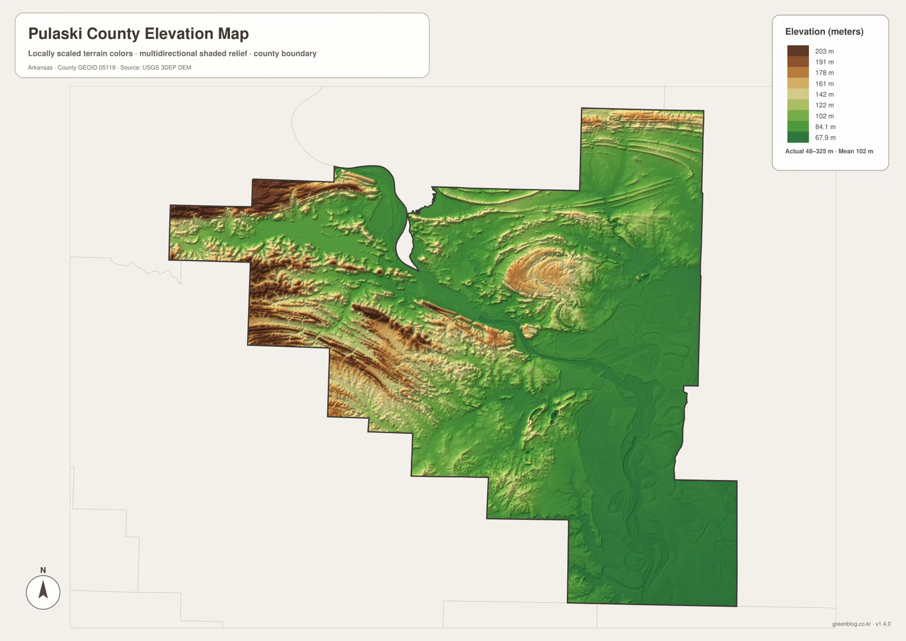
Comparing this view with the water map helps connect terrain and drainage without turning the page into a technical report. The Maumelle and Little Maumelle rivers cut through the higher western side before reaching lower ground near the Arkansas River. Farther east and south, waterways occupy a flatter landscape. The elevation surface is generalized for county-scale comparison, so it should not be used as a survey, engineering measurement, construction grade, or parcel-level elevation source. Detailed work requires the underlying USGS data or professional field measurements.
Why Little Rock is only part of the Pulaski County story
Little Rock is both the county seat and the capital of Arkansas, so it naturally dominates a search for Pulaski County. The county map, however, shows why stopping at the city boundary gives an incomplete picture. North Little Rock occupies the opposite bank of the Arkansas River, Sherwood and Jacksonville extend the developed area far to the northeast, and Maumelle sits closer to the western hills. The county then continues beyond those communities into areas where waterways and terrain are more prominent than dense streets.
The official Pulaski County overview describes the county as a place where three of Arkansas’s natural divisions meet. That statement matches the broad contrast visible in the supplied maps: hills and incised valleys in the west, a major river corridor through the center, and much lower ground to the east and south. The page does not need a complicated physiographic classification to make the point. Looking at the same county through roads, water, cities, and elevation is enough to show why its western and eastern halves feel so different.
Choose the map that matches the question
For a quick county overview, the general map is the best starting point because it combines the boundary, communities, surrounding counties, and major numbered roads. The city map is cleaner when the goal is to explain where Little Rock, North Little Rock, Sherwood, Jacksonville, Maumelle, and Wrightsville sit relative to one another. A report about the Arkansas River or western tributaries is easier to illustrate with the terrain-and-water map, while the elevation map is the clearest choice for showing the transition from western ridges to eastern and southern lowlands.
When printing, choose one or two maps that directly support the topic instead of shrinking every view into a crowded panel. The downloadable originals measure 3638 by 2572 pixels, larger than the page previews, and are prepared for A3 use. Keeping the original proportions will preserve labels and boundary shapes more clearly in a handout or slide. For legal boundaries, real-time road navigation, flood decisions, or engineering measurements, use the relevant current agency source in addition to these reference maps.
Frequently Asked Questions
What is the county seat of Pulaski County?
Little Rock is the county seat, and it is also the capital of Arkansas. The county map places Little Rock on the south side of the Arkansas River with North Little Rock directly across the river, making the relationship between the two central cities easy to see.
Which map is best for comparing Little Rock with Sherwood, Jacksonville, and Maumelle?
Use the city map first. It isolates six principal places and makes their relative positions easier to compare than the busier road map. Return to the general map when you need the highways and county boundary that connect those places.
Can the elevation map be used for surveying or construction measurements?
No. It is a county-scale reference map designed to show broad differences such as the higher western ridges and lower Arkansas River corridor. Surveying, grading, drainage design, and parcel-level decisions require detailed source data or professional measurements.
Map File Information
The ZIP contains the original high-resolution JPG versions of the Pulaski County general, city, terrain-and-water, and elevation maps.
- Included Files: General county map, city map, terrain-and-water map, and elevation map
- Printable Size: 3638 × 2572 pixels each
- File Type: Four high-resolution JPG files in one ZIP archive
Related Maps
Sources and References
- Pulaski County Government Overview – official county information on the county seat, establishment, and regional setting.
- Encyclopedia of Arkansas: Pulaski County – county history and geographic background.
- U.S. Census Bureau TIGER/Line Shapefiles – official boundary and geographic reference data.
- USGS National Hydrography – national river, stream, and waterbody reference data.
- USGS 3D Elevation Program – elevation data and 3DEP documentation.
Green Map creates custom-edited map images using open geographic data sources such as geoBoundaries, Natural Earth, OpenStreetMap, and government open data.
These maps are edited visual materials, not raw data files, and are provided for education, documents, presentations, and graphic reference.