Shelby County sits at Tennessee’s far western edge, where the Mississippi River forms a broad, irregular boundary and Memphis occupies much of the central-western part of the county. The maps on this page are useful because they show that urban Shelby County is not simply “Memphis plus a border.” They also reveal an eastward chain of suburban cities, several major river systems, and a clear rise in elevation away from the Mississippi lowlands. High-resolution A3 JPG versions of the county, city, water, and elevation maps are available together in the download box below.
The strongest geographic contrast is west to east. Along the western side, the county edge bends with the Mississippi River and stays within comparatively low terrain. Moving eastward, the ground rises and the urban pattern breaks into places such as Bartlett, Germantown, Collierville, Lakeland, and Arlington. Millington stands farther north. Reading those locations together makes the shape of the county much easier to understand than treating Memphis as the only reference point.
Table of Contents
Memphis fills the central-western side of the county
The general county map shows Memphis spreading across a large part of the middle and west, close to the Mississippi River boundary. The western county line is noticeably different from the north and east sides because it follows the bends and channels of the river rather than a simple straight survey line. That makes the county outline immediately recognizable: broad urban land in the center, a winding river edge to the west, and a more regular boundary toward Tipton and Fayette counties.
Major route labels on the map include 51, 385, and 269, with a denser street and highway network around Memphis. North of the main urban core, Millington gives the county a second strong reference point. To the northeast and east are Bartlett, Lakeland, and Arlington, while Germantown and Collierville sit in the southeast. Instead of forming an even ring, these places create several distinct directions of travel from Memphis.
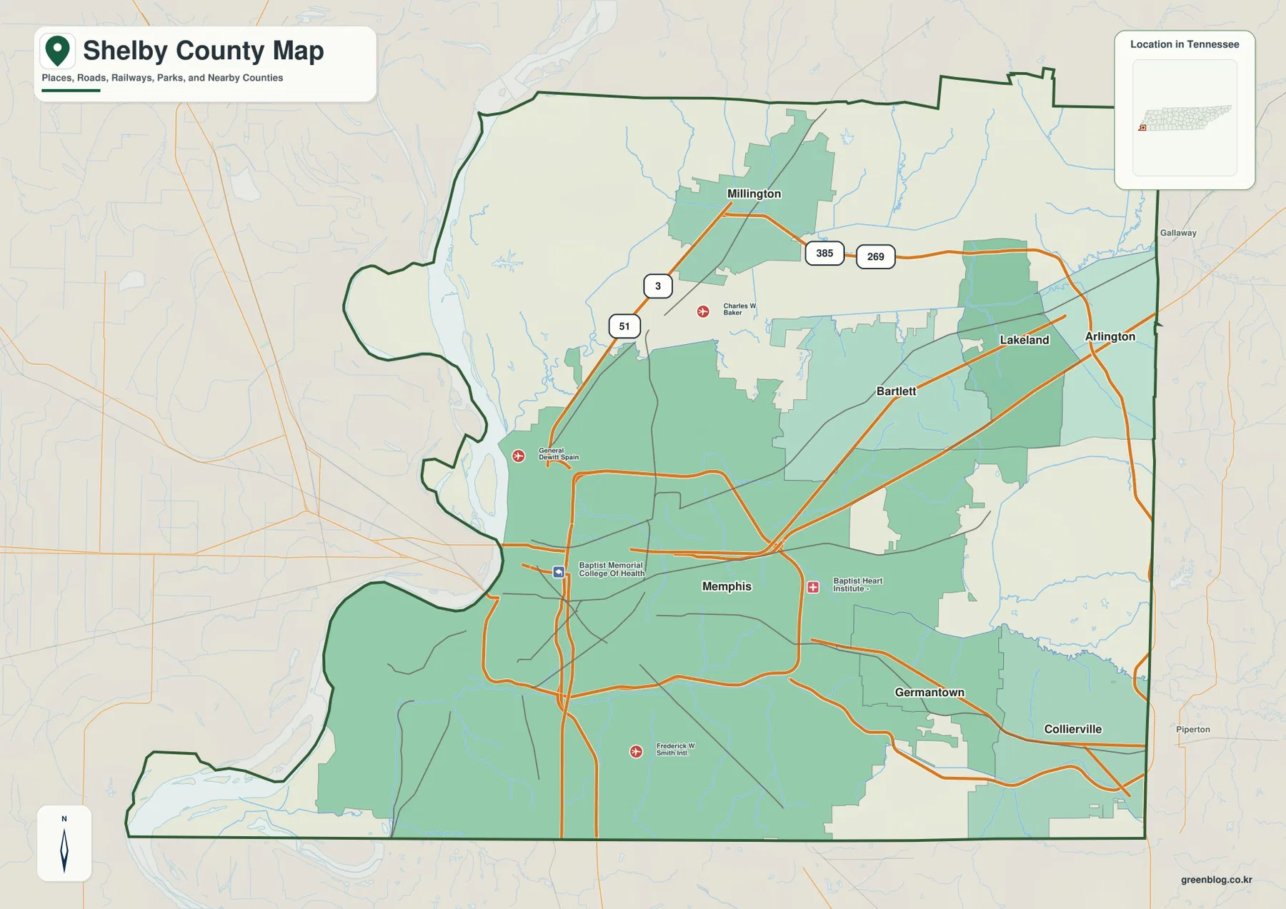
For boundary orientation, Tipton County is to the north and Fayette County is to the east. South of Shelby County are DeSoto and Marshall counties in Mississippi, while Crittenden County, Arkansas lies across the Mississippi River to the west. This matters in a metropolitan area because roads and continuous development can cross political boundaries without an obvious visual break. The county outline, not the extent of the built-up area, determines whether a place is inside Shelby County.
The largest city is west of an eastward arc of suburbs
The city map simplifies the background and ranks six major cities, making the internal settlement pattern easier to see. Memphis is the clear first-ranked city and sits well west of most of the other labeled cities. Bartlett lies to the northeast of Memphis. Farther southeast, Germantown and Collierville occupy a corridor near the county’s southern and eastern side, while Lakeland and Arlington form a smaller pair toward the northeast.
That arrangement is useful for understanding why “east Memphis” and the eastern suburbs can feel geographically continuous even though the municipalities are separate. The map does not show each municipal boundary as a detailed legal line, but it does make the relative positions obvious. Collierville is farther east and south than Germantown; Arlington is farther east than Lakeland; Bartlett sits between the Memphis core and the northeastern edge. The overall pattern is a broad metropolitan area that becomes more segmented by city name as it approaches the eastern county line.
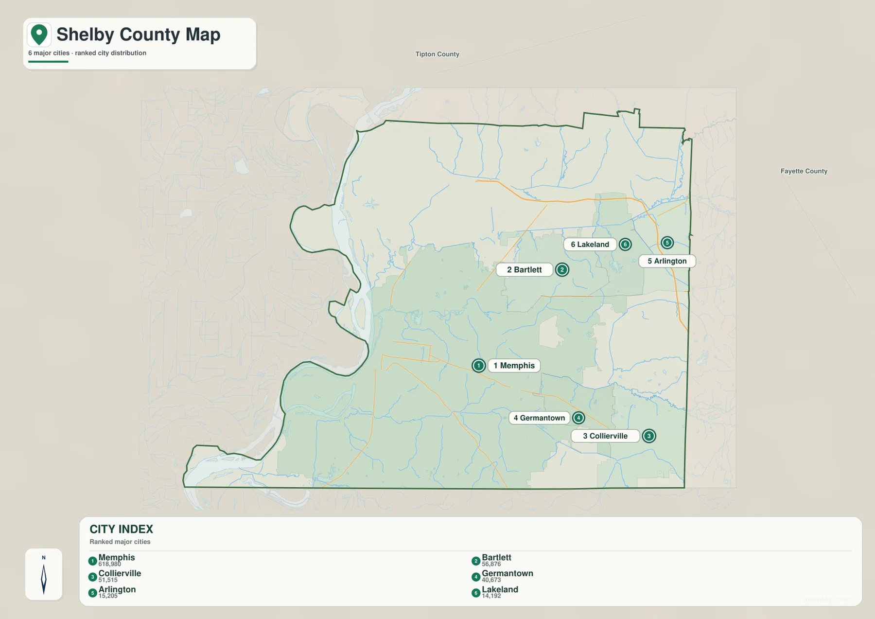
Millington appears on the broader county map rather than in the six-city ranking shown here, so using the two maps together gives a fuller picture of northern Shelby County. The city index should therefore be read as a selected comparison of major places, not as a complete municipal inventory. For an address, annexation question, or exact city limit, an official local boundary source is more appropriate than this county-scale reference.
The Mississippi River is only one part of Shelby County’s water network
The water map makes the western edge much more detailed. The Mississippi River runs north to south beside the county, but the river corridor also contains side channels, lakes, and low-lying water features. Willow Lake and Poplar Tree Lake appear near the northwest side, while Mud Lake and Robco Lake are labeled farther south. Harbor Channel and the Ten Mile Bayou Diversion Channel add another layer to the complex riverfront environment near Memphis.
Inside the county, the Loosahatchie River is one of the clearest east-west features. It enters from the eastern side and crosses the northern half of the county before reaching the lower terrain near the Mississippi. Farther south, the Wolf River and a labeled tributary extend through the metropolitan area, while Nonconnah Creek appears near the southeastern side. Big Creek Canal is labeled in the northeast. These waterways help explain why the county’s drainage cannot be understood from the Mississippi River alone.
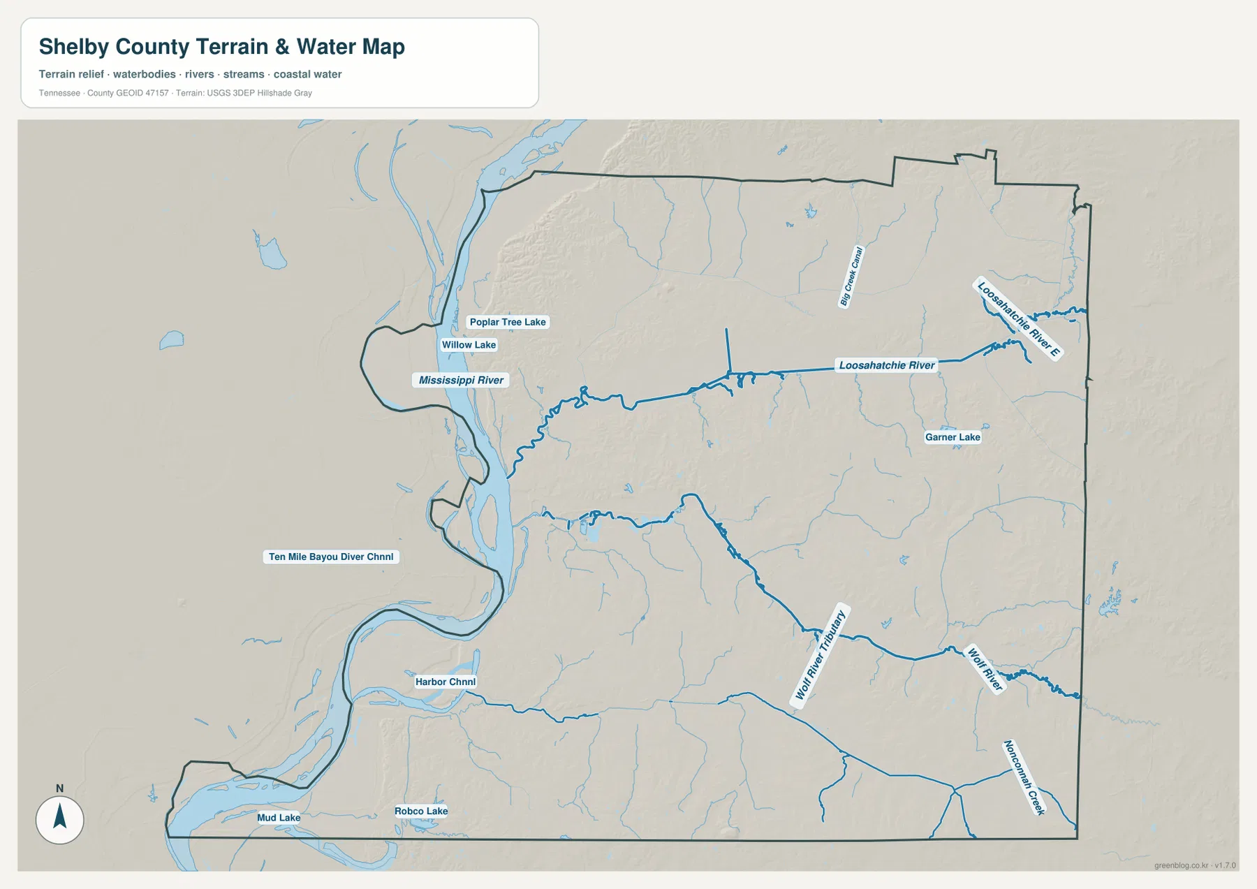
This is a reference map for the location of water features, not a flood-hazard or navigation chart. A lake or channel shown near the Mississippi does not by itself indicate current water level, access, or flood exposure. The same caution applies to smaller creeks through developed areas. For real-time river conditions, boating, flood planning, or engineering work, the appropriate agency data should be checked separately.
Elevation rises away from the Mississippi lowlands
The elevation map adds a physical explanation for the west-to-east contrast. Its stated countywide elevation range is about 54 to 155 meters, with a mean of 87 meters. The lowest broad area is along the western Mississippi River side, shown in deeper greens. East of the river lowlands, the surface gradually becomes more varied, and the eastern and southeastern portions contain more yellow and brown relief.
Shelby County is not a mountain county, so the elevation differences are best understood as lowlands, terraces, shallow valleys, and rolling uplands rather than dramatic peaks. Even so, the relief is distinct enough to shape the appearance of the drainage network. Narrow lower corridors extend through the more elevated eastern terrain, matching the general positions of rivers and creeks seen on the water map.
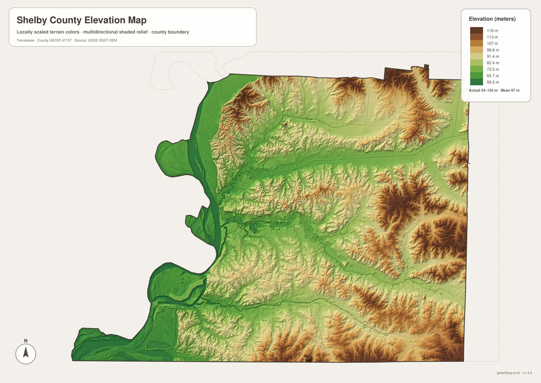
The map is particularly useful when paired with the city map. Memphis occupies a broad zone between the very low western river margin and the more pronounced eastern relief. Bartlett, Germantown, Collierville, Lakeland, and Arlington are farther from the main Mississippi floodplain and closer to the more varied eastern terrain. The elevation image is generalized, however, and should not be treated as survey-grade data for a parcel, construction site, or drainage design.
Putting the urban pattern, waterways, and relief together
Seen together, the four maps describe one county from complementary angles. The general map is strongest for recognizing the county outline and the relationship among roads and named places. The city map removes much of the visual clutter and makes the Memphis-to-eastern-suburbs arrangement easy to compare. The water map explains the winding western edge and the interior rivers, while the elevation map shows why the west looks broadly low and the east becomes more textured.
One of the most useful comparisons is between the Loosahatchie and Wolf river corridors and the city pattern. Both rivers cross parts of the metropolitan landscape rather than staying at the county’s outer edge. On the elevation map, lower corridors cut through or alongside higher ground. On the road map, the principal routes must cross those features at selected points. This makes the maps useful for geographic orientation even without showing every street, bridge, or drainage structure.
The existing county data in the package lists a 2020 Census population of 929,744 and a July 2025 estimate of 910,226. It also gives about 752.8 square miles of land and 28.8 square miles of water from the Gazetteer data used by the earlier page. Those figures establish the scale of a large metropolitan county, but they do not describe where residents are concentrated. For that, the city distribution and road network are more informative than a single countywide average.
Which Shelby County map should you use?
Choose the general county map when the main question is where Memphis, Millington, Bartlett, Germantown, Collierville, Lakeland, and Arlington sit relative to roads and the county boundary. Use the city map when the goal is a cleaner comparison of the principal municipalities. The water map is better for tracing the Mississippi, Loosahatchie, Wolf, and Nonconnah systems, while the elevation map is the clearest way to compare the low western margin with the higher eastern side.
For printed notes, it is often easier to keep the purposes separate rather than marking everything on one page. A city-and-road copy can be used for regional orientation, while a second copy can be marked with rivers, lakes, and elevation changes. Because the original files are larger than the web previews, they are also more suitable for A3 printing or for cropping a section of the county without immediately losing label clarity.
Frequently Asked Questions
Where is Memphis within Shelby County?
Memphis occupies much of the central-western part of Shelby County and lies close to the Mississippi River. Bartlett is northeast of the Memphis core, Germantown and Collierville are to the southeast, and Lakeland and Arlington are farther northeast. Starting with Memphis and then comparing the eastern cities is the simplest way to understand the county’s metropolitan layout.
Which waterways besides the Mississippi River are most visible on the map?
The Loosahatchie River is prominent across the northern half of the county, while the Wolf River system is visible farther south. Nonconnah Creek appears near the southeastern side, and Big Creek Canal is labeled in the northeast. The map also identifies several lakes and channels along the Mississippi River corridor, showing that Shelby County has a much more detailed water network than the main river alone.
How much elevation change does the Shelby County elevation map show?
The map states an actual elevation range of roughly 54 to 155 meters, with a mean near 87 meters. The lowest broad terrain is next to the Mississippi River, and the county generally becomes higher and more rolling toward the east. The difference is substantial enough to be visible at county scale, but it represents lowlands and uplands rather than mountain terrain.
Map File Information
The download contains the high-resolution JPG originals for the Shelby County general map, city map, water map, and elevation map shown on this page. The original JPG files are better suited to printing and enlargement than the lighter WebP previews used in the article.
- Included Files: County map, city map, water map, and elevation map
- File Type: ZIP containing four JPG images
Related Maps
Sources and References
- Tennessee State Library and Archives Shelby County fact sheet
- Tennessee Department of Transportation Shelby County map
- U.S. Census Bureau Shelby County QuickFacts
- USGS National Hydrography
- USGS 3D Elevation Program
Green Map creates custom-edited map images using open geographic data sources such as geoBoundaries, Natural Earth, OpenStreetMap, and government open data. These maps are edited visual materials, not raw data files, and are provided for education, documents, presentations, and graphic reference.