Greenwood County lies in southeastern Kansas, where Eureka provides the clearest starting point for understanding settlements, highways, the Fall River and Verdigris River systems, and the transition from higher western hills to lower eastern valleys. Eureka is the county seat and largest city, U.S. 54 crosses the area east to west, and K-99 provides a strong north-south reference. Madison lies in the north, while Severy, Fall River, and Climax help orient the southern half. High-resolution JPG versions of the maps are available together in the ZIP box below. High-resolution map files are available for download in the section below.
The county’s physical geography is organized around two major drainage systems. Fall River gathers branches from the west and crosses the central-southern county, while the Verdigris River forms a broad low corridor along the east. East Branch Fall River, West Branch Fall River, South Branch Verdigris River, Willow Creek, Slate Creek, Homer Creek, Bachelor Creek, and Salt Creek divide the surrounding hills into many narrow valleys. The elevation surface ranges from about 268 to 508 meters with a mean near 359 meters.
The Kansas Historical Society places Greenwood County across the Osage Cuestas and Flint Hills Uplands and emphasizes its long association with tallgrass prairie and cattle grazing. Fall River State Park adds another distinctive landscape in the southeast, where prairie, wooded floodplain, and reservoir shoreline meet. Taken together, the city, water, and elevation maps show a county that is far more varied than a simple road grid suggests.
Table of Contents
Eureka at the junction of U.S. 54 and K-99
Eureka is the strongest orientation point on the general county map. U.S. 54 crosses the city from west to east, while K-99 extends north and south. Their intersection makes Eureka a practical reference for both the northern communities and the broad southern rural area. The road corridor continues west toward Butler County and east toward the Neal area and the Greenwood County Courthouse label.
Madison anchors the northern part of the county, with Hamilton farther south in the north-central interior. Severy lies close to the southern boundary along the U.S. 400 and K-96 corridor, while Fall River occupies the southeast and Climax sits south of Eureka. Beaumont and Piedmont appear near or beyond the southwestern boundary and help place Greenwood County within the surrounding regional road network.
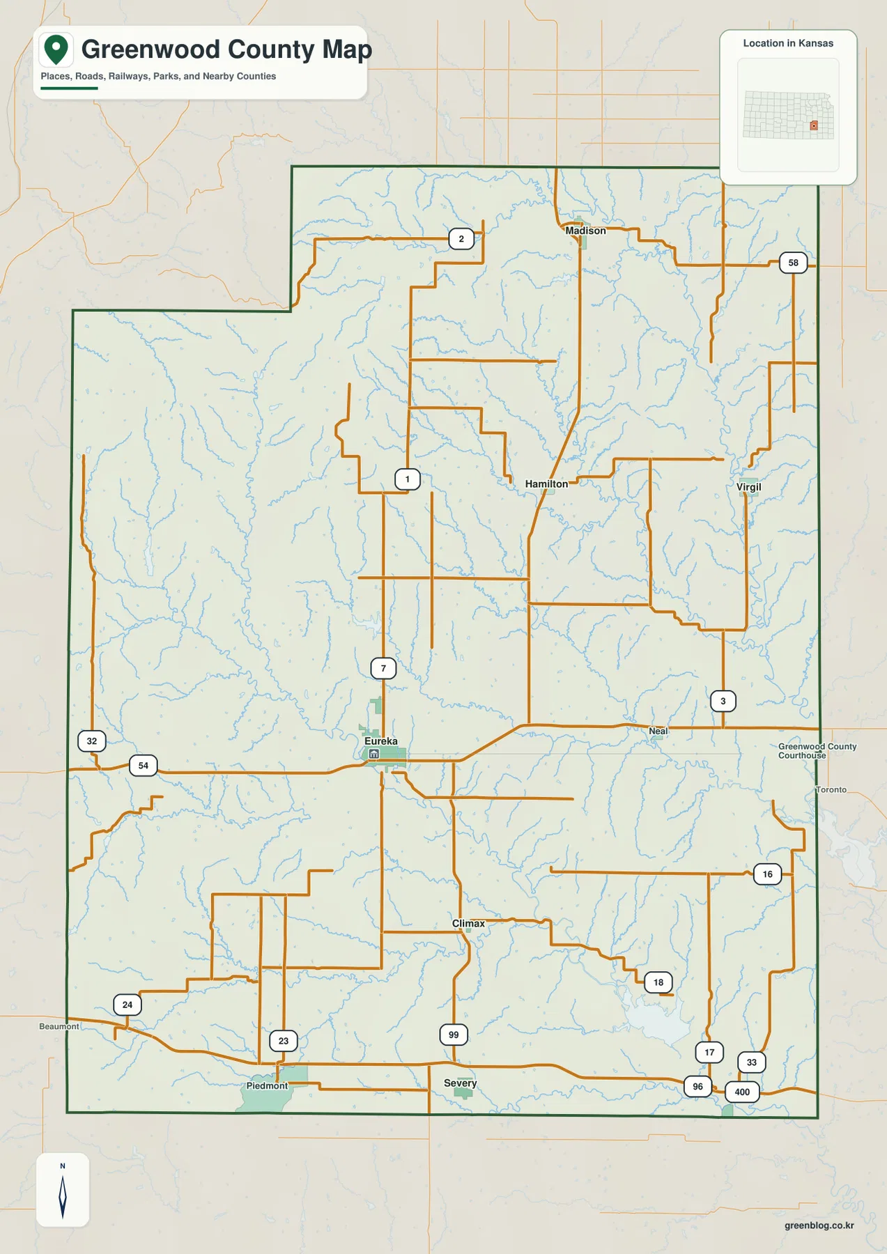
Greenwood County has an irregular outline, especially along the west and southwest, and includes a northwestern extension rather than a simple rectangular boundary. Roads often bend or shift around valleys and ridges. The map is intended for county-scale orientation rather than live navigation, so current construction, unpaved-road conditions, storm impacts, and low-water crossings should be checked through current transportation sources.
Eureka, Madison, Severy, Hamilton, Fall River, and Climax
The city distribution map ranks Eureka first, Madison second, and Severy third among the six major communities shown. Hamilton, Fall River, and Climax complete the ranked list. Eureka clearly dominates the settlement pattern, while the smaller towns are widely separated across northern and southern Greenwood County.
Madison is a useful northern reference near the Verdigris tributary network, and Hamilton marks the north-central interior. Severy and Fall River help define the southern half, while Climax lies between Eureka and the southern boundary. Rather than forming one continuous urban corridor, the communities function as scattered service points within a predominantly rural county.
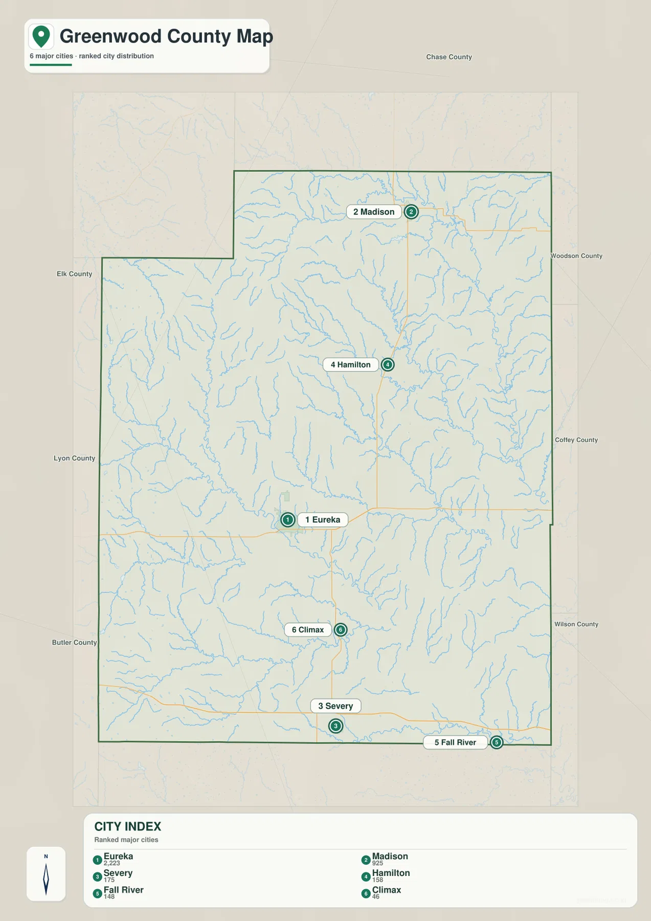
The Kansas Historical Society identifies Eureka as the county seat, and its county database records Eureka as the largest incorporated place. Once the settlement pattern is understood, the general map becomes easier to follow because U.S. 54, K-99, and U.S. 400 can be connected to familiar community anchors instead of being treated as isolated highway numbers.
Fall River and the Verdigris River drainage network
The terrain and water map is dominated by Fall River in the west-central and southern part of the county and the Verdigris River in the east. Fall River receives the East Branch Fall River and West Branch Fall River before continuing southeast. The Verdigris River follows a long north-south lowland near the eastern side and receives numerous short tributaries from the surrounding hills.
South Branch Verdigris River crosses the north-central area, while Willow Creek and Slate Creek cut through nearby uplands. Homer Creek and Bachelor Creek mark smaller valleys southeast of Eureka. Salt Creek appears in the southern county near the Fall River Lake area. Cities Services Lake and Munger Lake add smaller standing-water features to the network.
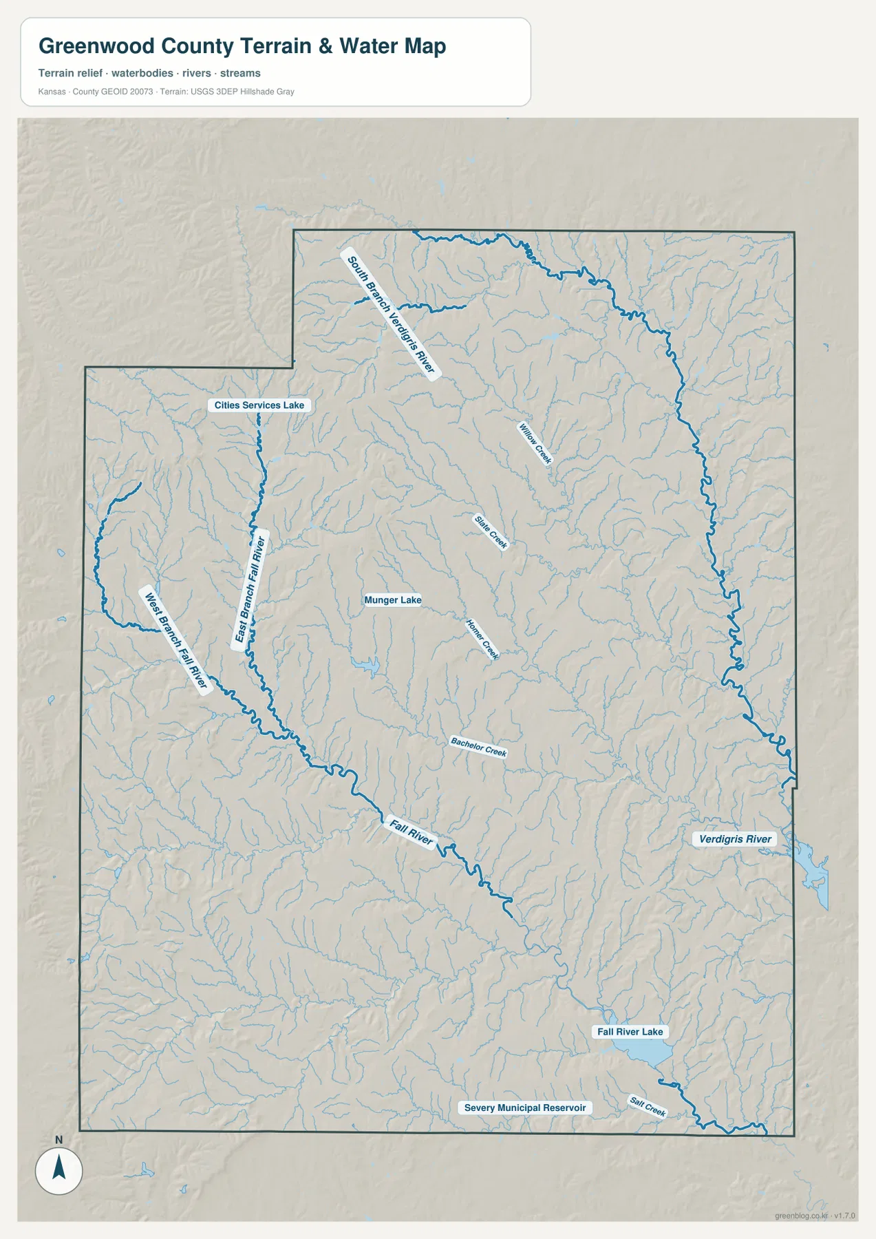
Fall River Lake and Severy Municipal Reservoir are labeled in the southern county. The Kansas Department of Wildlife and Parks describes Fall River State Park as a transition zone between Flint Hills grasslands and Cross Timbers vegetation, with Fall River feeding the reservoir. The water map is not a live hydrology product, so current lake levels, flood conditions, streamflow, or water quality should be checked through USGS or responsible local agencies.
A 268–508 meter contrast between western hills and eastern lowlands
The elevation map shows an actual county range of approximately 268 to 508 meters and a mean elevation near 359 meters. Brown and orange terrain dominates much of the west and southwest, indicating the county’s highest broad ridges. Moving east, the map shifts into yellow, light green, and darker green as the land drops toward the Verdigris River system.
Fall River creates another important low corridor through the center and southeast, but the eastern Verdigris valley is especially broad and low. Western ridges are densely cut by small tributaries, producing repeated narrow valleys. The northeast is also strongly dissected by the South Branch Verdigris River and smaller streams, but its overall surface lies well below much of the west.
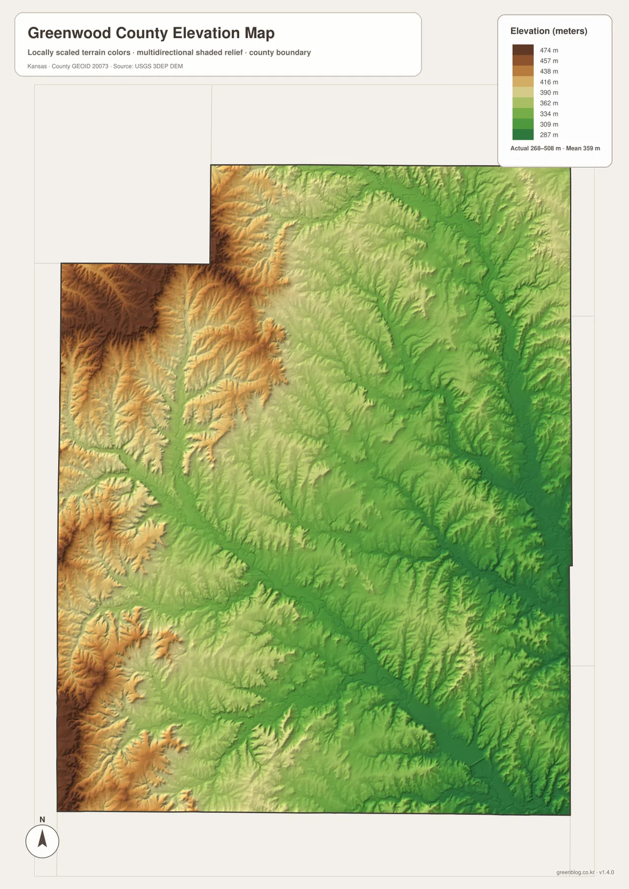
This elevation surface is intended for county-scale comparison rather than survey-grade measurement. It should not be used to establish exact parcel elevations, design drainage, or replace engineering and legal survey data. Its value is visual context: readers can compare Eureka and the Fall River corridor with the higher western hills and the much lower Verdigris River valley.
Tallgrass prairie, cattle country, and Fall River State Park
The Kansas Historical Society places Greenwood County in both the Osage Cuestas and Flint Hills Uplands and describes the region’s long connection with bluestem pasture and cattle grazing. Rocky, rolling prairie limited cultivation in many places but supported extensive grazing, helping shape a landscape of large ranches and tallgrass pasture. The higher western terrain on the elevation map provides a clear physical setting for that history.
Eureka developed as the county seat and later became an important stop along U.S. 54. The Kansas Historical Society also notes Eureka’s historic horse-racing reputation, which once earned it the nickname “Racing Capital of Kansas.” On the modern map, the city’s central role is still easy to see because U.S. 54 and K-99 converge there.
Fall River State Park gives the county a strong recreation and conservation reference. Kansas Department of Wildlife and Parks describes the park as a mix of forested floodplains, blackjack savanna, and tallgrass prairie, with Fall River flowing into the reservoir. Viewing the park area on the water and elevation maps shows how reservoir shoreline, river valley, prairie, and rolling hills fit together in southeastern Greenwood County.
Using the maps for study, printing, and county orientation
For basic orientation, begin with Eureka, U.S. 54, and K-99, then place Madison, Severy, and Hamilton around them. For physical geography, trace Fall River and the Verdigris River, then add East Branch Fall River, South Branch Verdigris River, and Willow Creek. The elevation view explains why the western county feels hillier and why the eastern river country occupies lower terrain.
The high-resolution JPG files in the ZIP are better suited than reduced web previews for printing, classroom projects, local-history materials, and close inspection of labels. They are useful for county overviews and regional comparison, but current roads, live stream conditions, parcel boundaries, and exact elevations should always be checked against the latest authoritative sources when those details matter.
Frequently Asked Questions
Where is Eureka on the Greenwood County map?
Eureka sits slightly south of the county center and serves as the county seat and largest city. U.S. 54 runs east and west through the area, while K-99 provides the main north-south reference, making Eureka the easiest starting point for county orientation.
Are Fall River and the Verdigris River the same waterway?
No. Fall River drains much of the western and central county and continues southeast, while the Verdigris River forms a separate major valley along the eastern side. Both systems are important for understanding Greenwood County’s drainage and low-elevation terrain.
Can the 268–508 meter elevation map be used for surveying?
No. The elevation map is a county-scale visual reference for comparing hills and river valleys. Exact parcel elevations, construction design, drainage engineering, and legal surveys require purpose-built data and professional methods appropriate to those tasks.
Map File Information
Download the high-resolution JPG files corresponding to the Greenwood County general, city distribution, terrain-and-water, and elevation maps in one ZIP archive.
- Included Files: Use only the versions confirmed in the article and supplied images
- File Type: Use the confirmed download contents
- Intended Use: Printing, education, presentations, and map-based projects
Related Maps
Sources and references
- Kansas Historical Society — Greenwood County, Kansas — Eureka, county history, Osage Cuestas, Flint Hills Uplands, and cattle-country context
- Kansas Department of Wildlife & Parks — Fall River State Park — reservoir, floodplain, prairie, and park information
- U.S. Census Bureau TIGER/Line — boundary, road, and geographic data resources
- USGS National Hydrography — hydrography and stream-network data information
- USGS 3D Elevation Program — elevation data information
Green Map creates custom-edited map images using open geographic data sources such as geoBoundaries, Natural Earth, OpenStreetMap, and government open data.
These maps are edited visual materials, not raw data files, and are provided for education, documents, presentations, and graphic reference.