St. Tammany Parish forms much of the north shore of Lake Pontchartrain, with Mandeville, Lacombe, and Slidell stretching across the southern edge while Covington, Abita Springs, and Folsom lie farther inland. I-12, I-10, I-59, and U.S. 190 concentrate transportation in the south and southeast, but the eastern boundary quickly becomes a maze of Pearl River channels and wetlands. This page explains those visible settlement, road, and water relationships, and the matching high-resolution JPG map files can be downloaded together in a ZIP.
Covington is the parish seat. Louisiana’s official St. Tammany Parish profile lists Covington, Mandeville, and Slidell as cities; Abita Springs, Madisonville, and Pearl River as towns; Folsom and Sun as villages; and Eden Isle and Lacombe among the census-designated places. On the supplied map, Covington works as the inland road hub, Mandeville marks the Lake Pontchartrain shore, and Slidell forms the largest southeastern urban area. Those three places provide a useful first framework for the parish.
Table of Contents
Covington anchors the inland road network beside the Tchefuncte River system
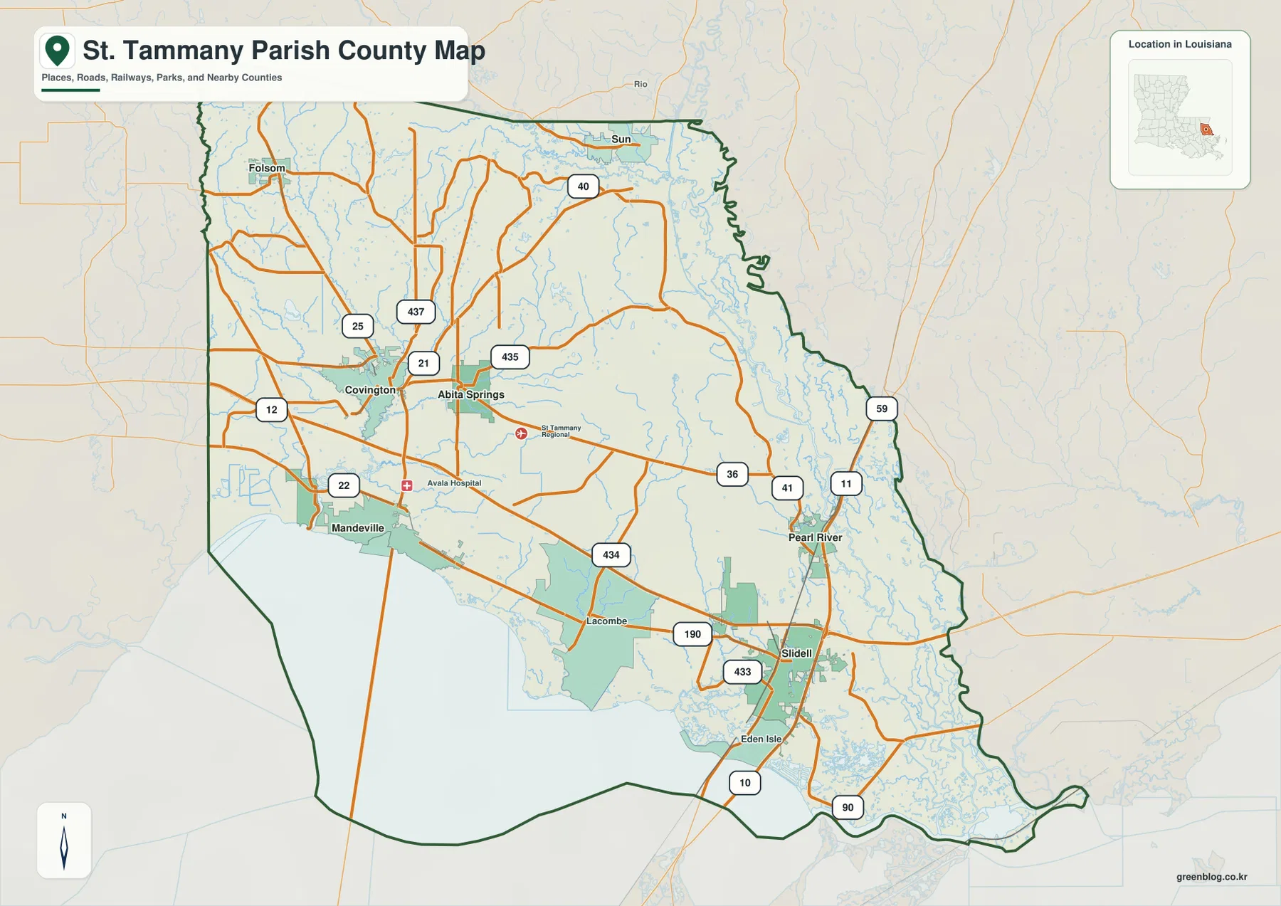
The general map places Covington in the west-central interior where LA 21, LA 25, LA 36, and several local routes converge. Mandeville lies south toward Lake Pontchartrain, Abita Springs sits just to the east, and Folsom is farther north. Covington therefore connects the denser lakeshore communities with the broader rural northern half of the parish.
LA 21 and LA 25 provide useful north-south references around Covington, while LA 36 helps with the Abita Springs side. LA 40 and LA 437 become more important farther north, and LA 435 appears to the east. This is a section where local state highways matter more than interstates, so it is easier to begin with Covington and add route numbers only after the nearby towns are located.
Mandeville, Lacombe, and Slidell line the north shore of Lake Pontchartrain
The southern edge of the parish follows Lake Pontchartrain for a long distance. Mandeville sits on the western shore segment, Lacombe lies farther east, and Slidell occupies the large southeastern urban area. LA 22 is useful around Mandeville, while U.S. 190 helps connect the Lacombe and Slidell side. I-12 provides the stronger regional east-west route across the southern parish.
Slidell is especially important because I-10, I-12, and I-59 converge around the city, with U.S. 190 and U.S. 90 adding more routes nearby. Eden Isle appears south of Slidell in a water-rich area, while Pearl River lies north of the city. The result is a southeastern corner where urban streets, major highways, rivers, and marsh channels all occupy the same part of the map.
Madisonville, Abita Springs, and Pearl River represent three different parish settings
Madisonville lies near the lakeshore west of Mandeville and provides a useful reference between Covington and Lake Pontchartrain. Abita Springs is inland east of Covington, where local roads and stream corridors matter more than the shoreline. Even though both towns are part of the broader southern population belt, their map settings are clearly different.
Pearl River sits northeast of Slidell near LA 41 and U.S. 11. Moving east from the town toward the parish boundary, developed areas thin out and West Pearl River channels become much more prominent. Pearl River therefore marks a useful transition from the southeastern urban network into the wetlands along the Louisiana–Mississippi side of the parish.
The ranked city index puts Slidell first and separates lakeshore towns from inland places
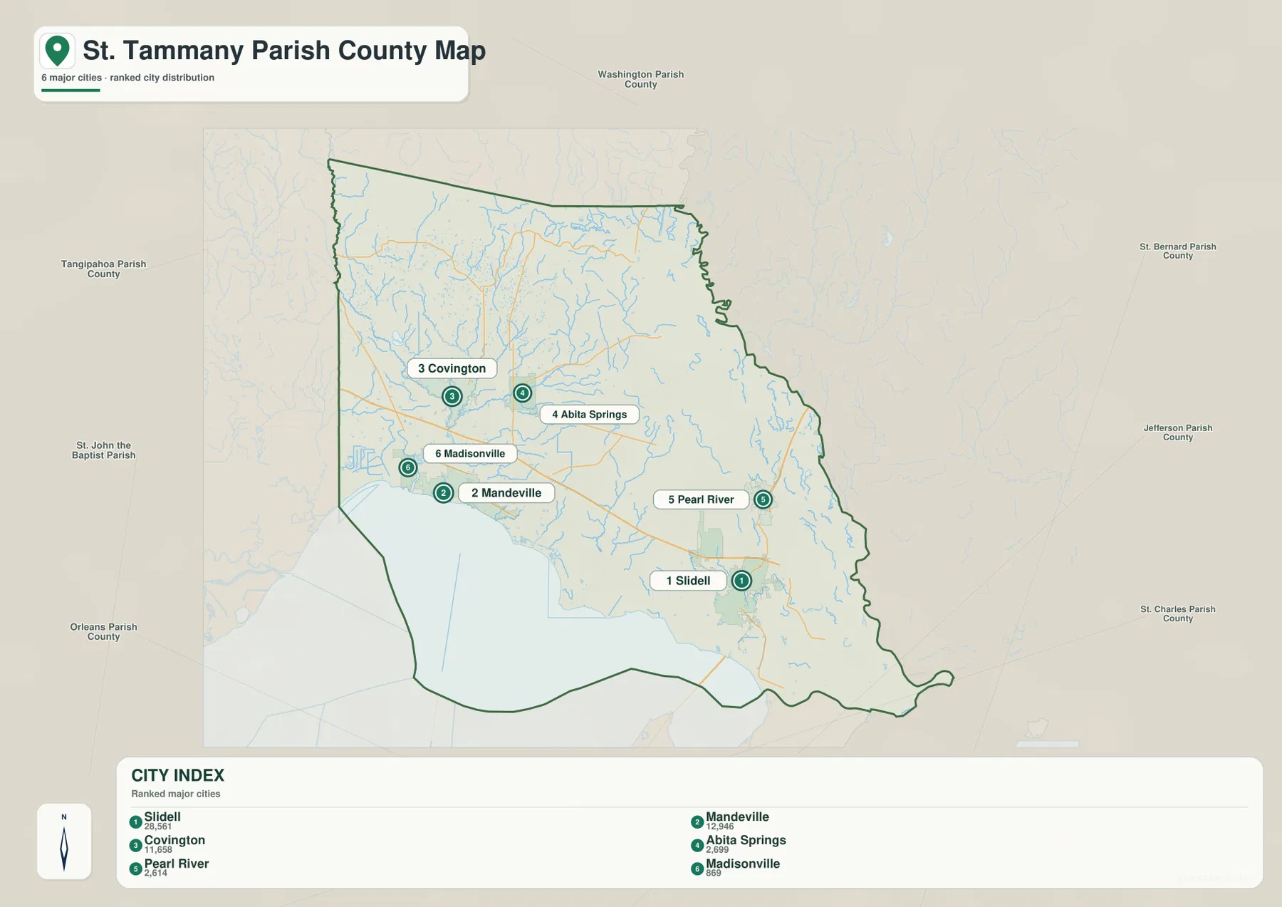
The city-index graphic ranks Slidell number 1, Mandeville 2, Covington 3, Abita Springs 4, Pearl River 5, and Madisonville 6. These numbers are rankings, not straight-line or driving distances. Slidell occupies the southeast, Mandeville and Madisonville lie close to Lake Pontchartrain, and Covington and Abita Springs sit inland, so the index also highlights how widely the selected communities are distributed.
Folsom, Sun, Lacombe, and Eden Isle are visible on the detailed map but are not included in the six-place ranking. The city map should therefore be used as a simplified comparison of selected major places rather than as a complete settlement list. The general map remains the better reference when local roads and additional communities matter.
The Tchefuncte River and Bogue Falaya system organize the western interior
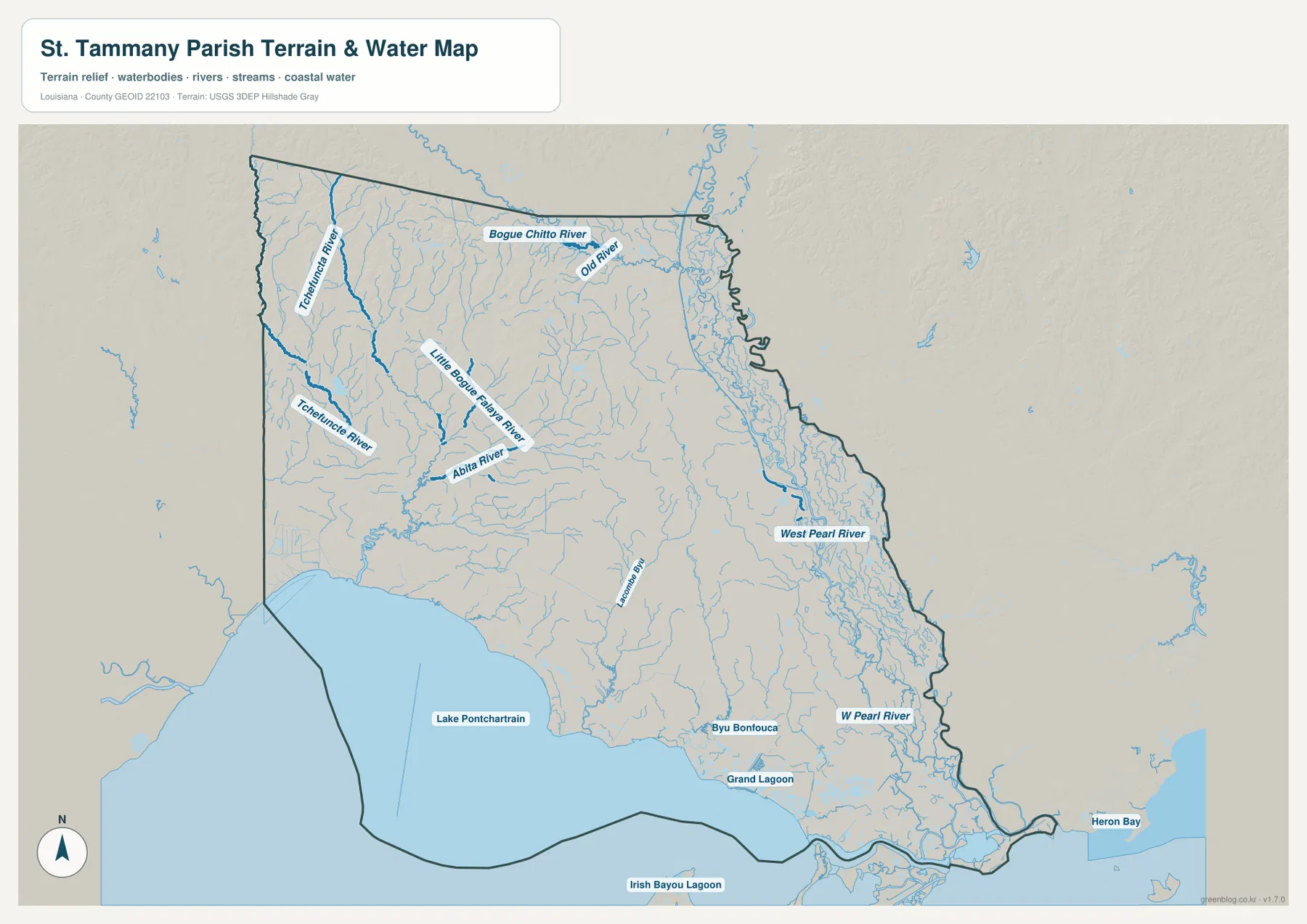
The terrain-and-water map gives the western and central interior a very different appearance from the highway view. The Tchefuncte River is a major north-south water reference, while the Little Bogue Falaya River and Abita River branch through the Covington–Abita Springs area. Numerous smaller tributaries fill the spaces between roads and communities.
Near the northern boundary, Bogue Chitto River and Old River provide larger regional water references. This part of the parish has fewer broad open-water areas than the lakeshore and instead shows a branching network of rivers and creeks. For the northern half, those stream systems often provide a better geographic framework than town names alone.
Pearl River wetlands and Lake Pontchartrain define the eastern and southern edges
West Pearl River and the main Pearl River channels dominate the eastern boundary and run through an extensive wetland corridor. Around Slidell and Pearl River, roads and developed areas remain visible, but the pattern becomes increasingly water-dominated toward the boundary. The river system is one of the most important natural features shaping the eastern outline of St. Tammany Parish.
Lake Pontchartrain fills much of the southern side, with Lacombe Bay, Bayou Bonfouca, and Grand Lagoon connecting the shoreline to interior wetlands. Heron Bay appears farther southeast, while Irish Bayou Lagoon provides wider regional context beyond the parish edge. This water map is intended for general geographic reference only; it does not provide flood-zone status, water depth, navigability, levee condition, or legal property boundaries.
Dividing the parish into inland, lakeshore, and Pearl River zones makes it easier to read
A practical first pass is to use Covington and Slidell as two major reference points. Covington represents the inland administrative and local-road center, while Slidell marks the southeastern interstate hub. Mandeville, Lacombe, and Abita Springs fill the area between them, with Folsom to the north and Pearl River to the east.
For water features, separate the western Tchefuncte system from Lake Pontchartrain along the south and the Pearl River wetlands along the east. The general map is best for roads and communities, the city index for the six ranked places, and the terrain-and-water map for rivers, lagoons, and wetlands. The original JPG is especially useful when small tributary labels are difficult to distinguish in the web preview.
High-resolution JPG files preserve interchange and wetland detail
The downloadable ZIP contains the original JPG files corresponding to the three previews on this page: the general parish map, the ranked city map, and the terrain-and-water map. Each original image is 3638 by 2572 pixels, providing more room to inspect route numbers, place names, rivers, lagoons, and wetland channels than the web preview. The larger files are especially useful around the Slidell interstate network and the Pearl River side.
Choose the general map when Covington, Mandeville, Slidell, and the major highways need to appear together. Use the city index for a quick comparison of the six selected communities. The water map is the better choice for the Tchefuncte River, Pearl River, Lake Pontchartrain, and the connected wetland network. These are general reference maps rather than legal boundary, survey, flood-risk, or real-time navigation products.
Frequently Asked Questions
What is the parish seat of St. Tammany Parish?
Covington is the parish seat. Louisiana’s official parish profile identifies Covington as the seat, and the supplied map also makes it the clearest inland road hub. Mandeville lies south on Lake Pontchartrain, while Slidell forms the larger southeastern highway center.
Do the numbers 1 through 6 on the city map show distance from Covington?
No. They are rankings for Slidell, Mandeville, Covington, Abita Springs, Pearl River, and Madisonville, not straight-line or driving distances. Actual travel mileage and time should be checked with the general road map and current navigation information.
Can the Lake Pontchartrain and Pearl River map be used for flood or boating decisions?
No. It is a general geographic reference showing Lake Pontchartrain, the Tchefuncte River, Pearl River channels, lagoons, and wetlands. It does not provide flood-zone classifications, water depth, navigation clearance, levee status, or legal property boundaries. Those decisions require current specialized information.
Map File Information
The ZIP contains the original high-resolution JPG files corresponding to the general parish map, ranked city map, and terrain-and-water map shown on this page.
- Included Files: parish map JPG, ranked city map JPG, terrain-and-water map JPG
Related Maps
Sources and references
For parish-seat and municipality information, see the Louisiana.gov St. Tammany Parish Profile and St. Tammany Parish Government. Current road and place context is available from the Louisiana DOTD St. Tammany Parish Official Map. General boundary data are documented by the U.S. Census Bureau TIGER/Line Shapefiles, and national water-feature data are documented through USGS National Hydrography.
Green Map creates custom-edited map images using open geographic data sources such as geoBoundaries, Natural Earth, OpenStreetMap, and government open data. These maps are edited visual materials, not raw data files, and are provided for education, documents, presentations, and graphic reference.