If you need a Prairie County Arkansas Map for printing, a presentation, or a larger document, you can download the original high-resolution A3 JPG files from this page in one ZIP. Prairie County sits in east-central Arkansas where a mostly rural road grid meets the broad lowlands of the White River. Hazen provides a convenient inland reference point, while Des Arc lies to the north and DeValls Bluff is farther east near the river.
The maps are designed for practical location reading rather than technical GIS analysis. You can follow the county boundary and major roads, compare the spacing of Hazen and other communities, trace the White and Cache rivers with smaller creeks and reservoirs, and see where elevation changes across the county. The county may look almost flat at first glance, but the elevation view makes the somewhat higher western ground and lower eastern river country easy to compare.
Prairie County also has an unusual administrative arrangement: Des Arc and DeValls Bluff both serve as county seats. The county material included with this rewrite package explains that northern and southern districts were established in 1885, when White River flooding made travel across the county difficult. The modern maps are not historical flood maps, but the separation of the two seats and the river between them helps explain why the arrangement developed.
Table of Contents
Start with Hazen to make sense of the county road network
Hazen is a useful first landmark because it sits slightly south of the county’s middle and connects to several important routes. U.S. 70 runs east–west through this part of Prairie County, while Arkansas 11 and 249 provide north–south connections. From Hazen, Des Arc is clearly to the north, and DeValls Bluff and Fredonia (Biscoe) are to the east.
The southern part of the county shows additional U.S. highways, including 63, 79, and 165, along with state roads that continue toward neighboring counties. The road pattern does not point to one dominant center. Instead, different routes serve the north, east, and south, which fits the county’s spread-out settlement pattern.
The county boundary is equally distinctive. It has a projecting northern section, several bends along the eastern river side, and narrow or stepped portions in the south. Nearby place labels such as Carlisle, Clarendon, and Stuttgart provide regional orientation beyond the county line. Reading the roads and boundary together is the quickest way to understand where Prairie County sits within this part of Arkansas.
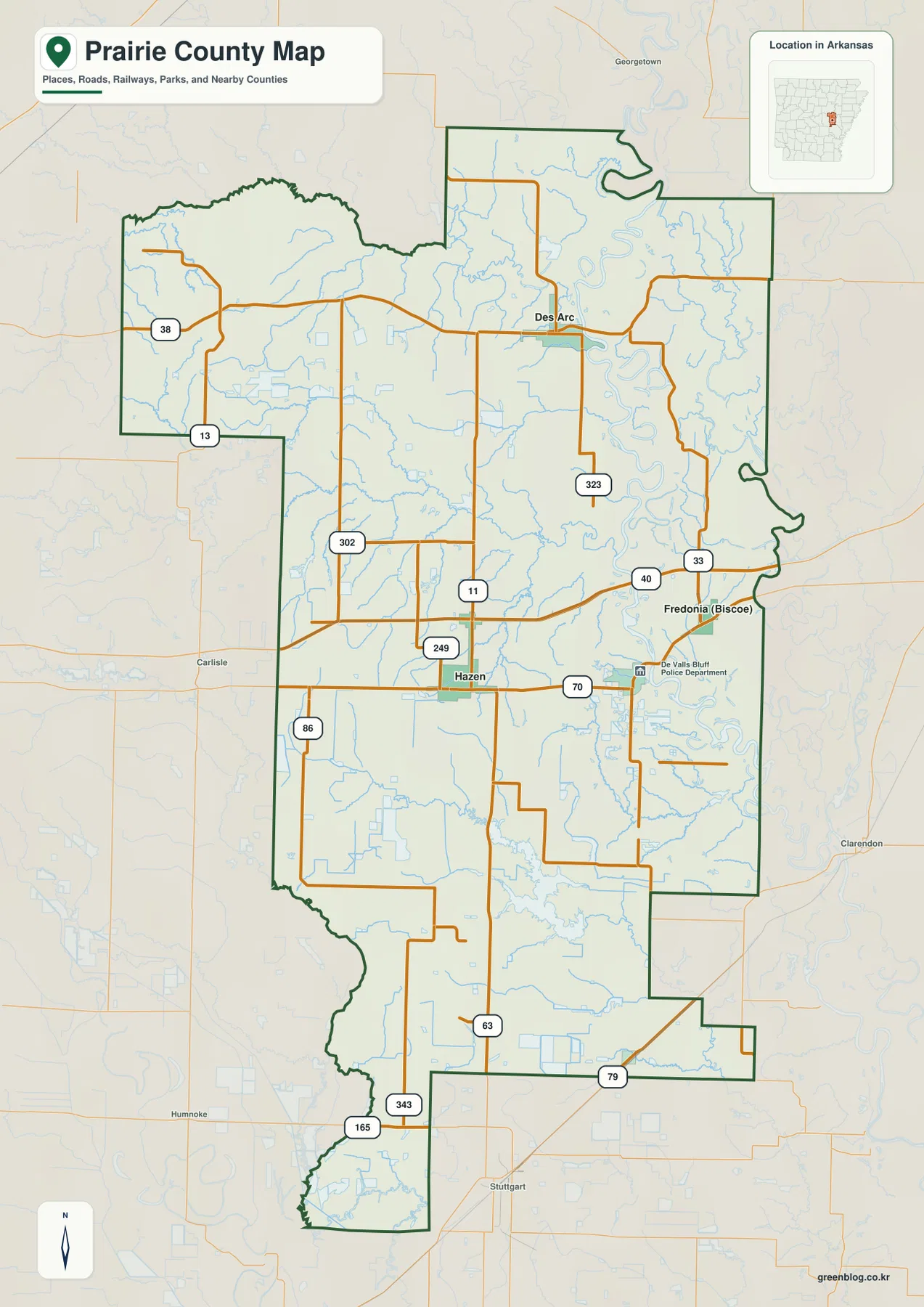
Use this general map before moving to the more specialized views. It answers the basic questions first: where the principal communities are, which direction the major roads run, and how the long irregular county shape reaches north and south. Once those locations are familiar, the water and elevation maps are easier to interpret without getting lost in place names.
Des Arc and DeValls Bluff show why Prairie County has more than one local center
Des Arc occupies the northern part of the county near a large bend of the White River. DeValls Bluff lies farther south and east in the river lowlands, while Hazen is inland between the two in a different road setting. The two county seats therefore do not appear as neighboring parts of a single urban area; they are separate places serving different parts of the county.
According to the Encyclopedia of Arkansas material included with the package, Prairie County was created in 1846 and took its name from the Grand Prairie. Des Arc became the county seat in 1875. Ten years later, the county was divided into northern and southern districts, with courthouses in Des Arc and DeValls Bluff. The same source connects that arrangement to the difficulty of traveling across the county when the White River flooded.
Modern roads have changed local travel, but the maps still show the physical setting behind that history. A wide river corridor and low ground separate the eastern communities, and the road network approaches the two seats from different directions. For a reader who simply wants to know why Prairie County has two seats, this geographic view provides a clearer explanation than a list of dates alone.
White River bends, old channels, and smaller creeks shape the eastern side
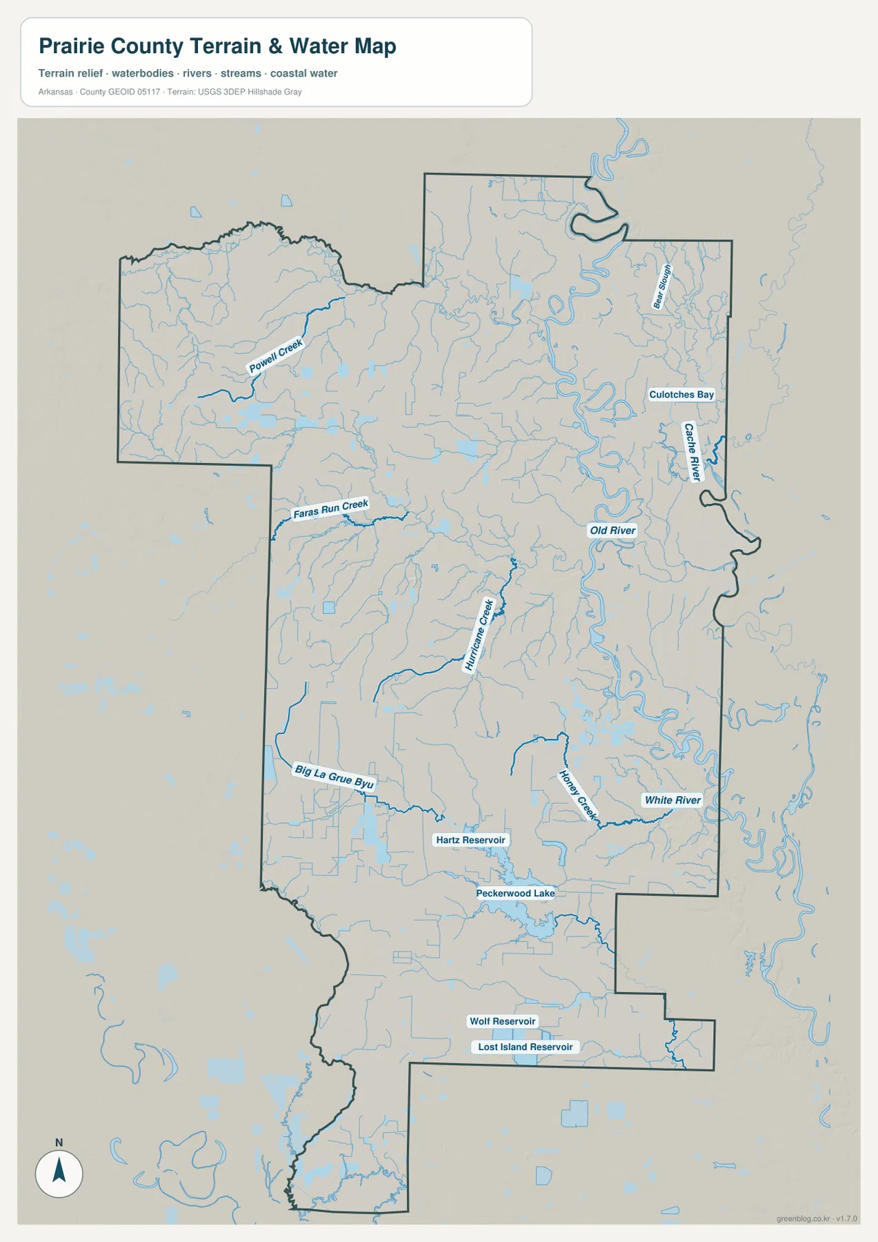
The water map changes the county’s appearance more than any other view. The White River crosses the eastern side in broad loops, and Old River is labeled near a separated or cutoff-looking bend. The Cache River appears close to the eastern boundary. Together, these features make the east look much more water-filled than the simpler road map suggests.
Des Arc is closely associated with the White River in the north, and the City of Des Arc source in the package describes the community as being along the lower White River. DeValls Bluff is tied to the river farther downstream. Their positions on different sections of the same major river help explain why Prairie County developed separate northern and southern administrative centers.
Smaller waterways fill in the rest of the map. Powell Creek is labeled in the northwest, Faras Run Creek farther south, and Hurricane Creek through the central area. Big La Grue Bayou appears in the southwest, while Honey Creek and Bear Slough are among the named features closer to the eastern lowlands. These labels show that the county’s water geography is not limited to the White River alone.
Several named lakes and reservoirs also appear in the southern part of the map, including Hartz Reservoir, Peckerwood Lake, Wolf Reservoir, and Lost Island Reservoir. They are useful location references south of Hazen and around the more sparsely labeled rural areas. This map should not be used as a flood-zone product, navigation chart, levee-safety map, or legal water-boundary document; those questions require current specialized agency information.
Elevation stays low overall, but the western side is noticeably higher
Prairie County does not have mountain-scale relief, yet the elevation map shows meaningful differences within the county. Its legend gives an elevation range of roughly 50 to 86 meters and a mean near 62 meters. Western and northwestern areas appear in the higher colors, while much of the White River corridor and portions of the south are shown in lower greens.
The northwestern edge has the most visible local relief, with short valleys and slightly rougher terrain. Similar but gentler changes continue across the west-central area. Approaching the White River, the surface becomes lower and smoother. Hazen sits in the broad transition between those areas, while DeValls Bluff and the river country to the east occupy lower ground.
Comparing the elevation and water maps is useful because many of the largest river bends and lowland channels fall within the lower eastern colors. That visual overlap does not prove a specific flood risk or explain every channel, but it does show where low terrain and dense waterways occur together. For an ordinary map reader, the simplest takeaway is that Prairie County is lower in the east and somewhat higher in the west.
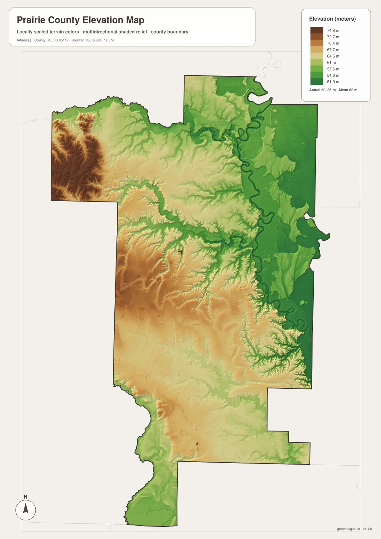
The elevation surface is intended for county-scale reference. It should not be used to determine a building-site elevation, road grade, drainage design, or survey benchmark. Readers who need detailed elevation measurements should use USGS 3D Elevation Program data or an appropriate survey. The page map is best for quickly comparing broad areas.
The city map is best for direction and spacing, not trip planning
The city view uses Hazen as its central reference and places Des Arc, De Valls Bluff, Fredonia (Biscoe), and Ulm around it. Straight-line distances are printed between Hazen and those communities: about 13 miles to Des Arc, 6 miles to De Valls Bluff, 9 miles to Fredonia, and 17 miles to Ulm. These are not driving distances.
Actual travel can be longer because vehicles must follow the road network, intersections, and available river crossings. The straight-line labels are still useful for a different reason: they make the spread of the county immediately visible. Des Arc is distinctly north of Hazen, DeValls Bluff and Fredonia are on the eastern side, and Ulm sits well to the south.
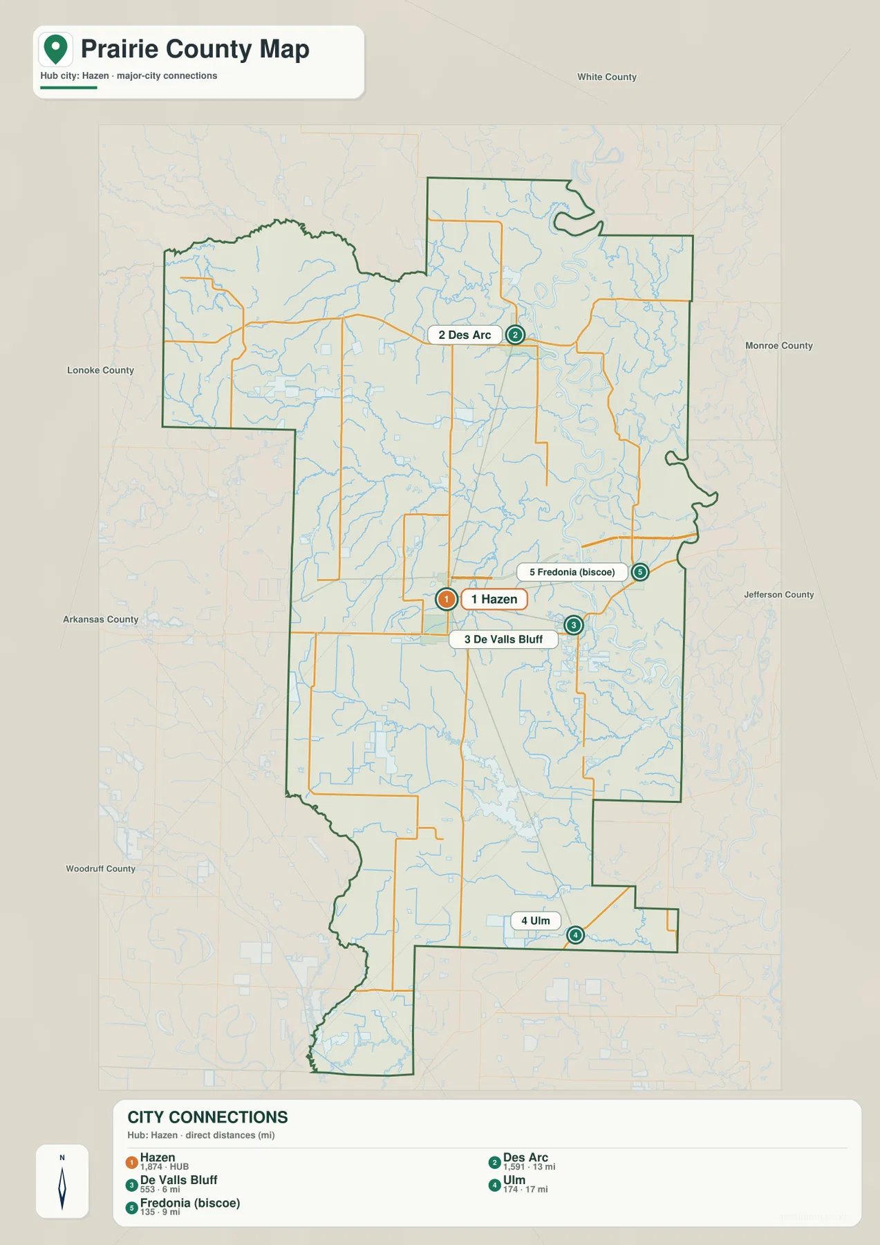
The map frame also includes neighboring county names such as White, Lonoke, Monroe, Jefferson, Arkansas, and Woodruff. Those labels are useful for regional orientation but should not be treated as a formal legal adjacency table. Numbers printed beside community names are part of the supplied map labeling; for current population or administrative statistics, readers should consult up-to-date official sources.
Choose the Prairie County map that matches the question
For a first look at Prairie County, begin with the general map. It combines the county outline, main roads, Hazen, Des Arc, DeValls Bluff, Fredonia, and nearby outside communities. When the goal is to compare how far the main places are spread around Hazen, the city map gives a cleaner view and adds direct-distance labels.
The water map is the better choice for the White River, Cache River, Old River, Big La Grue Bayou, named creeks, and southern reservoirs. If the question is about why the western side looks different from the river lowlands, the elevation map strips away much of the place-name detail and makes the higher west and lower east easier to compare.
For a handout or presentation, one map per topic is usually easier to read than four reduced images in a single panel. The WebP images on the page are convenient previews, while the downloadable JPG files preserve more detail when the map is enlarged or printed. Each original JPG is 2572 × 3638 pixels and is prepared for A3 use.
Frequently Asked Questions
Why does Prairie County have county seats in both Des Arc and DeValls Bluff?
The county history material in the package says Prairie County was divided into northern and southern districts in 1885, with courthouses in Des Arc and DeValls Bluff. Frequent White River flooding made travel between parts of the county difficult, which helps explain why two administrative centers were maintained.
Are the 6, 9, 13, and 17 mile labels on the city map driving distances?
No. They are straight-line distances from Hazen to the marked communities. Driving routes can be longer because they follow actual roads and available crossings, so use a current road-navigation service when you need trip mileage or travel time.
Can this water map be used to determine White River flood risk?
No. The map is a general reference for the location of rivers, creeks, sloughs, and reservoirs. Flood zones, levee conditions, property risk, and safety decisions require current specialized information from the responsible public agencies.
Can the water map be used to judge White River flood risk?
No. The water map is a geographic reference showing rivers, creeks, old channels, lakes, reservoirs, and terrain. It is not a FEMA flood map, navigation chart, levee-safety map, or legal boundary product. Use current official flood and river information for property, emergency, or safety decisions.
Map File Information
The ZIP contains four high-resolution A3 JPG maps for county orientation, community spacing, waterways, and elevation.
- Included Files: County map, city map, water map, and elevation map
- Printable Size: 2572 × 3638 pixels each
Related Maps
Sources and References
- Encyclopedia of Arkansas – Prairie County provides county history, the Grand Prairie name origin, and background on the Des Arc and DeValls Bluff county seats.
- City of Des Arc provides local information for Des Arc and its setting along the lower White River.
- University of Arkansas System Cooperative Extension – Prairie County provides local county information and extension-office details.
- USGS National Hydrography is an official U.S. reference for rivers, streams, and other hydrographic features.
- USGS 3D Elevation Program provides authoritative U.S. elevation and terrain data.
Green Map creates custom-edited map images using open geographic data sources such as geoBoundaries, Natural Earth, OpenStreetMap, and government open data.
These maps are edited visual materials, not raw data files, and are provided for education, documents, presentations, and graphic reference.