Jones County is easier to understand as a spread-out county of small communities, roads, and water than as a place organized around one dominant city. This page combines a county reference map with roads and place names, a simplified city-connections map for Maysville, Pollocksville, and Trenton, and a terrain-and-water map centered on the Trent River and the county’s many creeks and swamp channels. The web images are quick previews, while the file box near the end of the page provides matching high-resolution A3 JPG maps in a single ZIP archive for download.
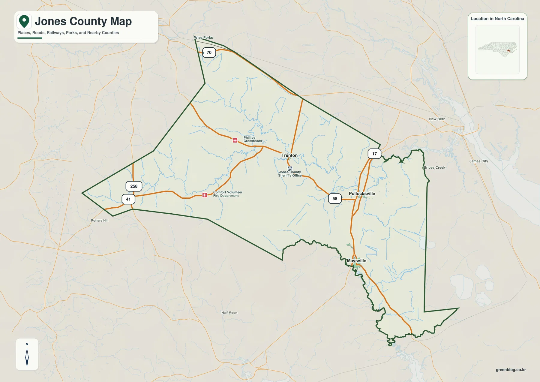
Trenton sits near the middle of the county and is the county-seat reference on the main map, but it should not be treated as the only useful landmark. Pollocksville is farther east, close to the Route 17 and Route 58 side of the county, while Maysville lies to the south on the same broad north-south side of the road network. Routes 41 and 258 appear near the western edge, and Route 70 is marked near the north. That arrangement gives Jones County several different approaches, so the fastest way to orient yourself is to find the town you need first and then match it to the nearby road and water features.
Table of Contents
Trenton is central, but the county does not revolve around one town
On the county map, Trenton is easy to locate because it appears close to the center and is accompanied by the Jones County Sheriff’s Office label. From there, the settlement pattern spreads rather than forming a single cluster. Pollocksville is positioned to the east near the Route 58 and Route 17 area, and Maysville is farther south near the lower part of the county. Phillips Crossroads and a few public-service labels add local reference points, but the strongest overall pattern is the distance between the three named towns rather than a dense chain of built-up places.
The map also keeps several outside places visible so the county boundary makes sense in a larger setting. New Bern and James City appear beyond the eastern side, Potter’s Hill is shown to the west, and Wise Forks sits near the northwestern corner of the map. Those names are not presented as communities inside Jones County; they are orientation points outside the boundary. This distinction matters because the county outline is irregular, especially on the western side and in the long southeastern extension. Reading the boundary together with the nearby place names helps prevent the roads at the edge from being mistaken for routes that remain inside the county for their entire length.
Road numbers separate the western, central, and eastern approaches
The western side of the main map is marked by Routes 41 and 258, while Route 70 appears near the northern edge. In the middle of the county, roads from Trenton continue toward the east, where Route 58 is labeled near Pollocksville. Route 17 then provides the clearest north-south reference on the eastern side and continues toward Maysville. You do not need to memorize every road to use the map. It is usually enough to think of 41 and 258 as western references, 58 as an eastward link from the Trenton area, and 17 as the road that helps separate Pollocksville from Maysville.
This reference map is not a turn-by-turn driving product, but it is useful when a place name alone is not enough. Pollocksville is much easier to find after you notice the intersection area around Routes 17 and 58. Maysville is lower on the same side of the county, so it can be located by following the north-south road pattern rather than searching the center of the map. Trenton requires a different approach because it sits inland from that eastern road line. Starting with the county outline and then matching each town to the nearest numbered road makes the map less crowded and more practical.
Maysville is the hub on the city map, with two straight-line comparisons
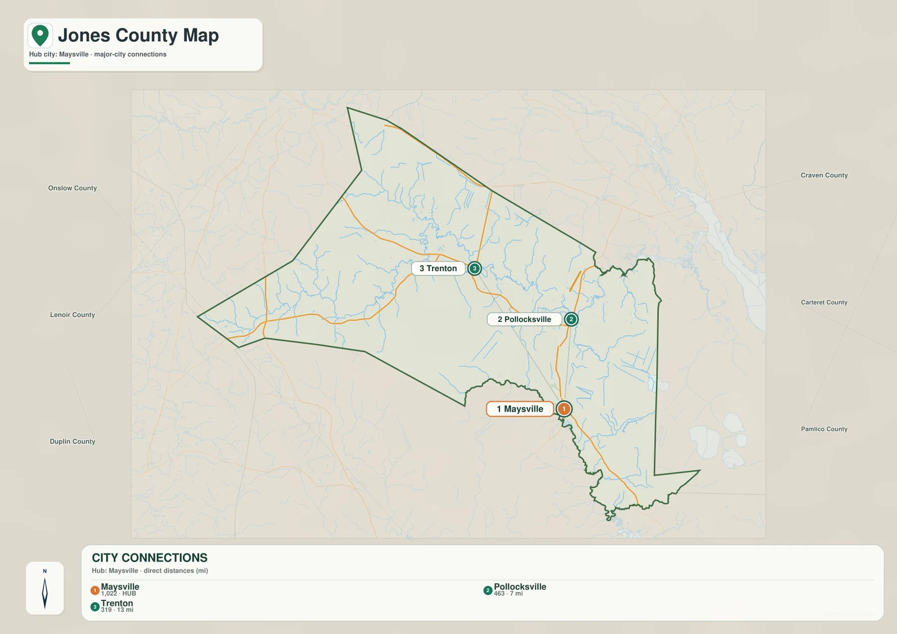
The city-connections map removes most of the smaller labels and road numbers so the three principal places can be compared directly. Maysville is marked as the hub with the map value 1,022. Pollocksville is labeled 463 and shown 7 miles from the hub, while Trenton is labeled 319 and shown 13 miles away. The legend states that these are direct distances, so they should be read as straight-line map distances rather than driving mileage. They are useful for comparing spacing and direction, but a traveler should return to the county map or a navigation service for actual road distance.
The simplified layout makes the triangular relationship among the three towns easy to see. Maysville is at the southern side of the group, Pollocksville is to the northeast, and Trenton lies to the northwest. County names around the outside—Onslow, Lenoir, Duplin, Craven, Carteret, and Pamlico—provide regional context without adding road clutter. They should be treated as surrounding labels rather than a claim that every one of those counties shares a direct boundary with Jones County. Once the three-town pattern is familiar, the detailed county map becomes much easier to read because the roads can be added back to a mental picture that is already organized.
The Trent River is only one part of a dense water network
The terrain-and-water map changes the emphasis completely. The Trent River is the easiest major feature to follow through the central and eastern part of the county, but it is joined by a large number of smaller streams and wet channels. Beaver Creek is labeled in the northwestern half, with Chinquapin Branch nearby. Tuckahoe Swamp appears toward the western end, while Crooked Run and Brock Pond provide additional references closer to the middle. On the eastern side of the Trent River area, Hancock Creek and Mill Creek show how quickly the main river branches into smaller named waterways.
The southern part of the map has a different water reference. White Oak River is labeled near the lower boundary, accompanied by Black Swamp Creek and Holston Creek. Great Lake is shown outside the county to the east, making it a useful surrounding landmark rather than an internal Jones County lake. These names make the water map especially useful when a road-only view feels empty. What looks like open space on the basic reference map contains many small channels on the water map, and those channels help explain why a simple town-and-road description cannot capture the whole county.
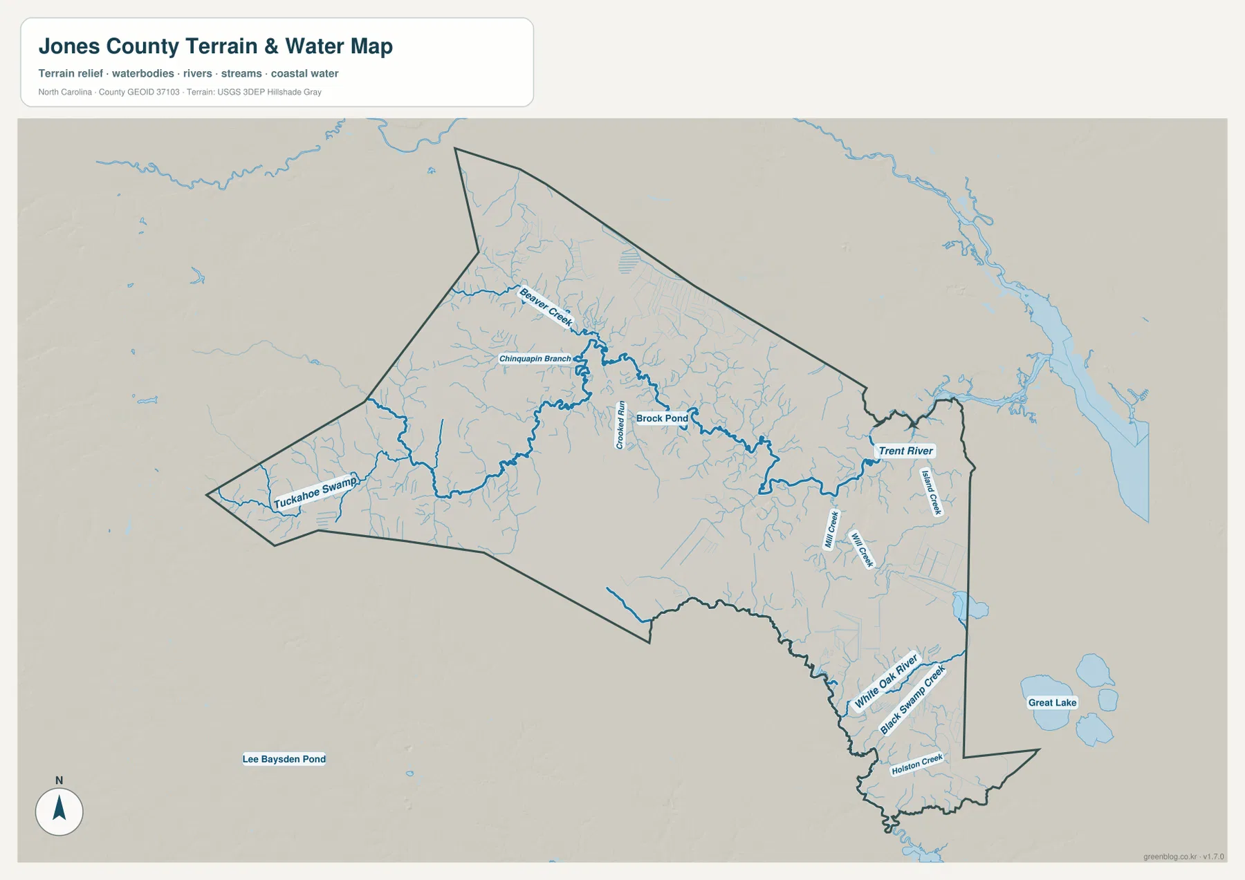
The terrain shading is subdued compared with a mountain-county map. It is better used as background context for the waterways than as a source of exact elevation measurements. This map does not provide survey-grade heights, legal water boundaries, flood-zone determinations, parcel limits, or navigation information. Its practical purpose is to show where named rivers, creeks, swamp channels, and ponds sit relative to the county outline. Following those features from west to east also makes it clear that Jones County cannot be reduced to the Trent River alone: the White Oak River area in the south and the western swamp-and-creek system form distinct parts of the same map.
Cross-reading roads and waterways changes how the three towns look
Trenton is a good example of why the maps work best together. On the county reference map, it is the central administrative landmark and a place where local roads spread in several directions. On the water map, the same central area is surrounded by branches that feed the Trent River, so the town no longer appears to sit in a blank interior. Pollocksville also changes depending on the map: the road view emphasizes its eastern location near Routes 17 and 58, while the water view places it close to the Trent River’s eastern course and nearby smaller creeks.
Maysville has its own role. The city map uses it as the hub for direct-distance comparisons, which makes it the quickest starting point for understanding the spacing among the three towns. The water map, however, draws attention farther south to the White Oak River and Black Swamp Creek area. That contrast is useful because it prevents the hub label from being mistaken for a statement that all county activity is centered there. Each map is answering a different practical question: where the roads and towns are, how the main communities are spaced, and where the major named waterways lie.
Choose the map according to the question you need to answer
Use the county reference map first when you need a broad orientation that combines the boundary, towns, road numbers, and nearby outside places. It is the best starting point for locating Trenton, Pollocksville, or Maysville and then seeing which road approaches that part of the county. Use the city-connections map when the road detail is distracting and you simply want to compare the direction and direct distance among the three named communities. Use the terrain-and-water map when the Trent River, White Oak River, Tuckahoe Swamp, Beaver Creek, or the smaller tributaries matter more than the road network.
For printing or document work, the ZIP below contains the same three map subjects as high-resolution A3 JPG files. It does not include a separate elevation map, land-cover map, flood map, parcel map, or legal boundary product. The download is therefore best suited to general geographic reference, classroom or study material, print layouts, and local orientation where the county boundary, principal towns, roads, and waterways are the main information needed.
Frequently Asked Questions
Which map is best for comparing Maysville, Pollocksville, and Trenton?
The city-connections map is the quickest choice when you only need direction and spacing. It uses Maysville as the hub and shows Pollocksville at 7 miles and Trenton at 13 miles by direct, straight-line distance. For actual road relationships, switch back to the county reference map and compare Routes 17, 58, 41, 258, and 70.
What waterways are shown besides the Trent River?
The map labels White Oak River, Beaver Creek, Chinquapin Branch, Tuckahoe Swamp, Hancock Creek, Black Swamp Creek, and Holston Creek, along with smaller features such as Brock Pond. Together they show that the county has several water references rather than one river running through otherwise empty land.
What is included in the downloadable ZIP?
The ZIP contains one high-resolution A3 JPG for the county reference map, one for the Maysville-centered city-connections map, and one for the terrain-and-water map showing the Trent River, White Oak River, and named tributaries.
Map File Information
The ZIP contains three high-resolution A3 JPG files matching the Jones County reference map, city-connections map, and terrain-and-water map shown on this page.
- Included Files: County map JPG, city-connections map JPG, terrain-and-water map JPG
- File Type: ZIP containing 3 JPG files
Related Maps
Sources and References
Green Map creates custom-edited map images using open geographic data sources such as geoBoundaries, Natural Earth, OpenStreetMap, and government open data.
These maps are edited visual materials, not raw data files, and are provided for education, documents, presentations, and graphic reference.