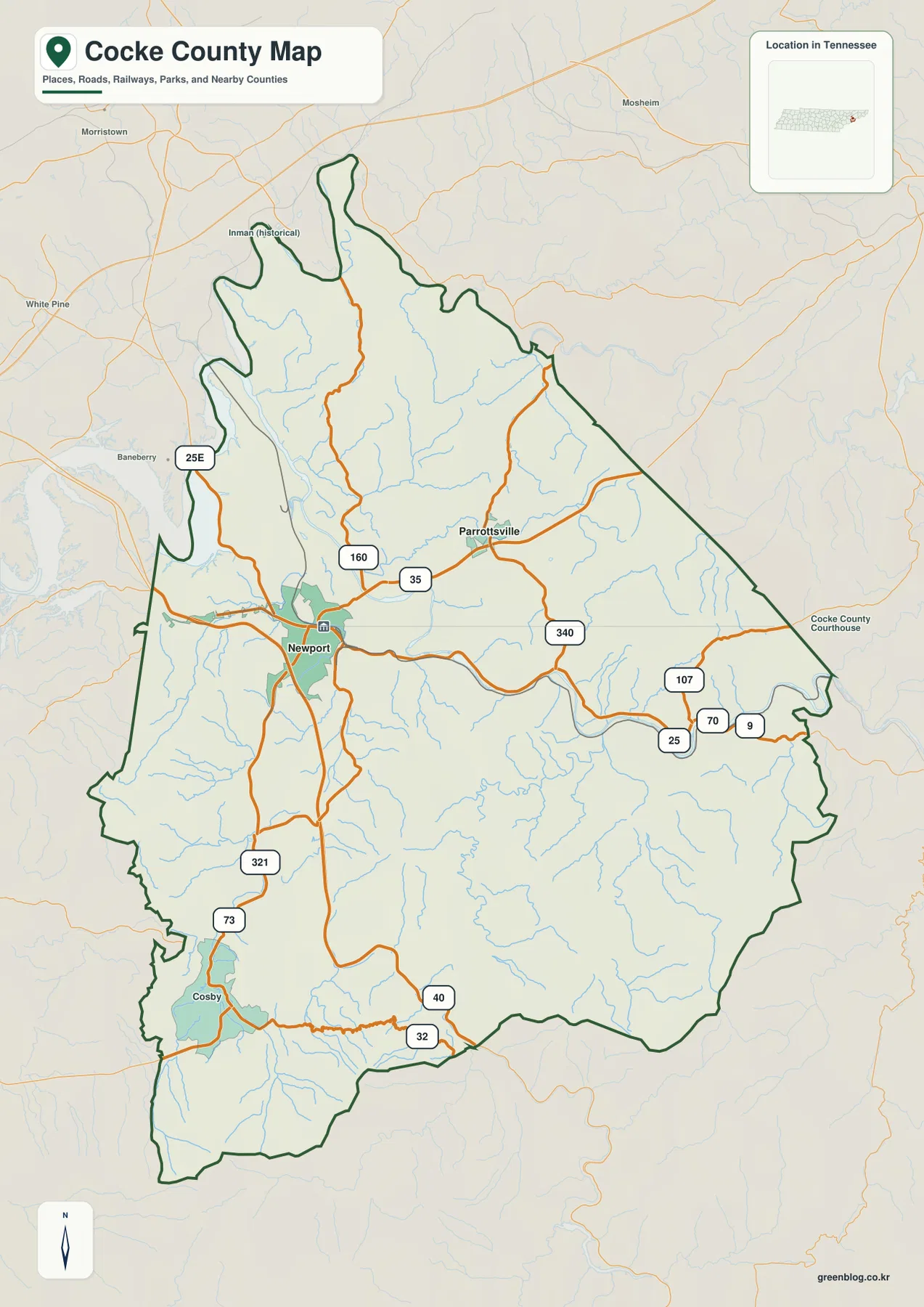
You can download the high-resolution JPG map files for Cocke County from this page, including county, city, water, and elevation views. The Cocke County Map is centered on Newport and shows how the county’s roads, river valleys, communities, and mountain terrain fit together across East Tennessee. The downloadable ZIP is intended for printing, classroom use, presentations, and personal annotation, while the WebP images in the article provide a faster on-screen preview.
Newport sits in the west-central part of the county and is the clearest place to begin. Parrottsville lies to the northeast, while Cosby appears farther south toward the mountain country. The road network is densest around Newport, then spreads into several valleys rather than radiating evenly across the county. That pattern becomes much easier to understand once the French Broad River, Pigeon River, and the higher southern terrain are viewed alongside the roads.
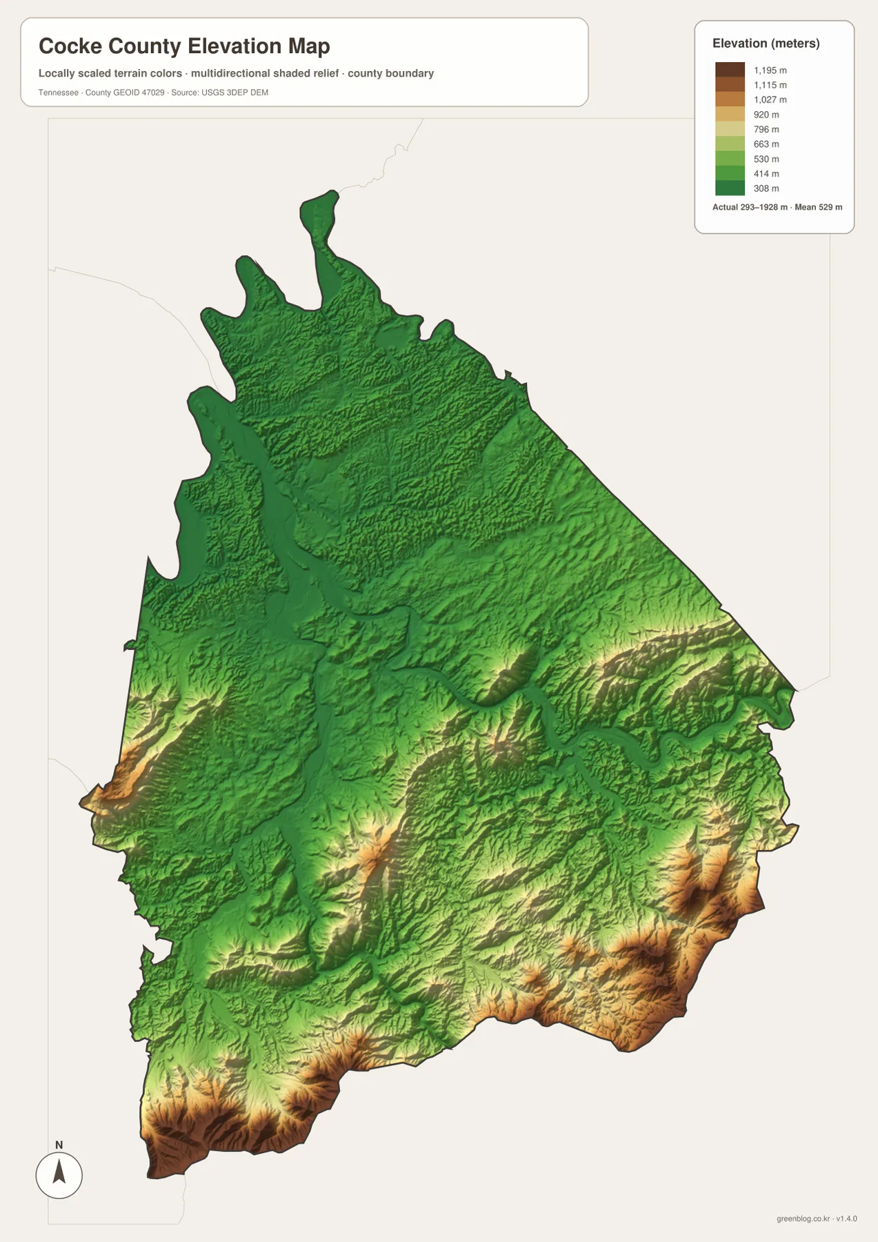
Cocke County also has a striking elevation range. The supplied elevation map shows an actual span from about 293 meters to 1,928 meters, with a mean near 529 meters. Lower ground follows broad river corridors around Newport and the northwestern part of the county, while steep ridges rise along the southern and southeastern edges. This contrast is one of the main reasons the county’s road and settlement pattern looks different from a flatter Tennessee county.
Table of Contents
Newport as the main road and county reference
The general county map places Newport near the center of the most connected road area. Parrottsville is separated from it to the northeast, and Cosby provides a useful southern reference near the mountain approaches. The county boundary is irregular, especially in the north where several narrow extensions reach outward, and along the eastern and southern sides where the outline follows a more rugged setting. Those shapes make the boundary itself important when comparing nearby towns and roads.
Route shields visible on the map include 25E, 160, 35, 340, 107, 70, 25, 9, 321, 73, 40, and 32. They do not form a simple grid. Some routes pass through the Newport area and continue east or west, while others turn south into narrower valleys or climb toward the county edge. Looking at those bends alongside the terrain helps explain why a direct-looking connection on a small map may follow a much longer road on the ground.
The background also shows places outside the county, including Morristown, White Pine, Baneberry, and Mosheim. They are useful for regional orientation but should not be treated as Cocke County communities simply because their labels appear close to the outline. The dark county boundary is the better guide when comparing the county with neighboring areas.
The city map separates Newport from Parrottsville
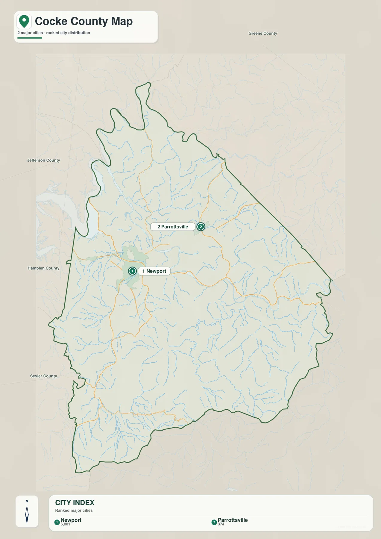
The city view deliberately keeps the settlement picture simple. Newport is ranked first in the map’s city index and Parrottsville second, making their positions easy to compare without a dense layer of minor place names. Newport lies farther west and south, while Parrottsville sits northeast of it. The spacing between the two gives a quick sense of how the populated part of the county extends across more than one valley.
Neighboring county labels add context. Jefferson County and Hamblen County are shown to the west, Greene County to the north, and Sevier County to the southwest. These labels help explain which side of Cocke County each city is closer to and make the county’s east-west and north-south orientation easier to follow.
The city map should be used for relative position rather than travel time. Roads in Cocke County bend around ridges, follow river valleys, and cross waterways at particular points, so a short straight-line separation on the image can correspond to a more complicated drive. For route planning, the city view works best as a starting reference before moving to the general road map.
French Broad River, Pigeon River, and the branching creek network
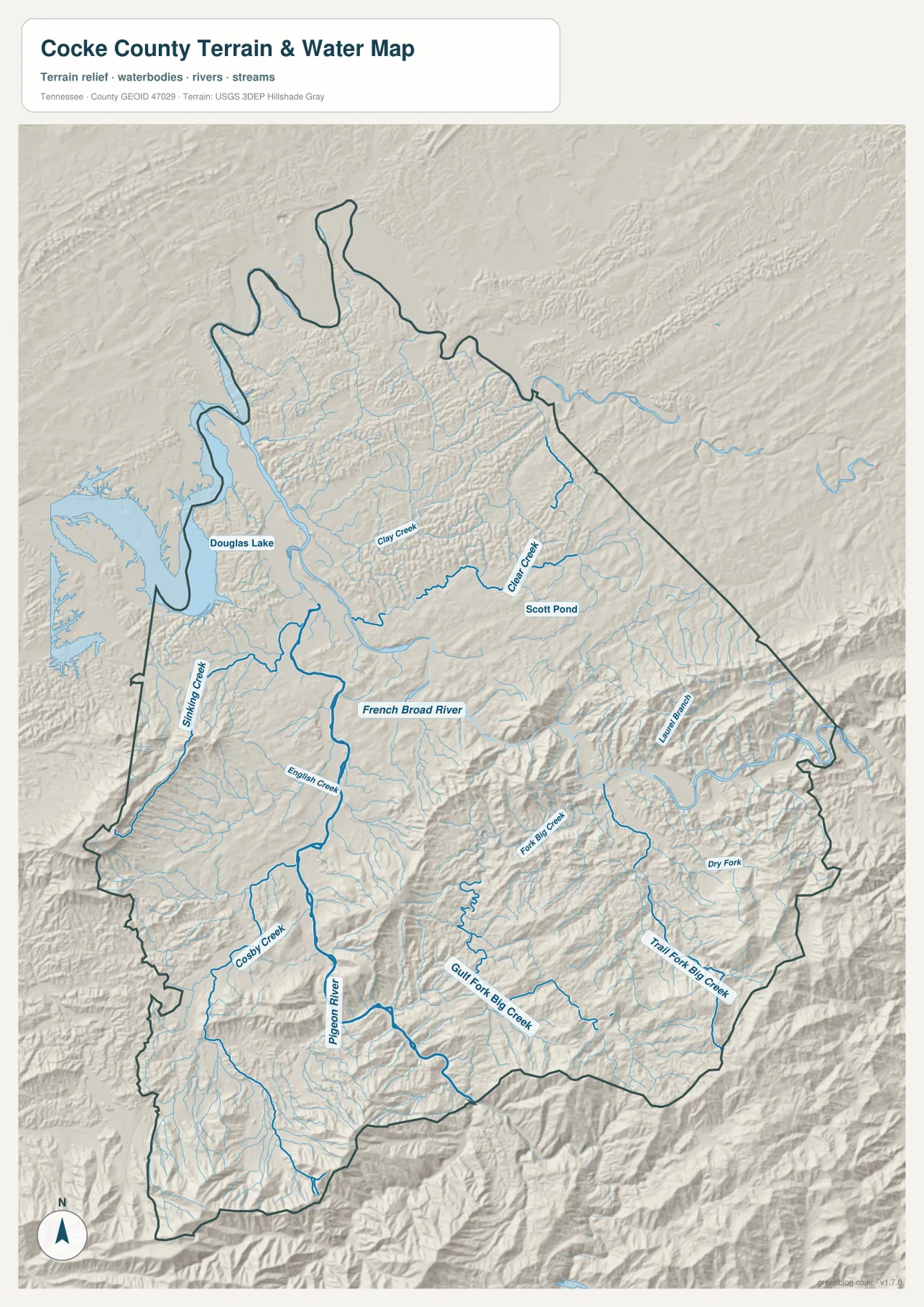
The terrain-and-water map gives the county a very different appearance from the road map. The French Broad River crosses the middle part of the county, while the Pigeon River comes north from the southern mountains toward the Newport area. Douglas Lake occupies a broad water area along the northwestern side. These three features provide a clear framework for understanding the county’s larger valleys before looking at smaller streams.
Named tributaries show how divided the landscape becomes away from the broad river corridors. Shifting Creek appears in the west, with English Creek and Cosby Creek farther south. Clay Creek and Clear Creek occupy the northern and northeastern interior, while Laurel Branch, Fork Big Creek, Gulf Fork Big Creek, Dry Fork, and Trail Fork Big Creek mark smaller mountain drainages toward the east and southeast. The number of short tributaries is consistent with the strongly ridged terrain visible beneath them.
This water view is a location and terrain reference, not a flood map or navigation chart. It does not provide current water levels, bridge conditions, boating rules, or flood forecasts. Its main value is showing how rivers and creeks occupy the low ground between ridges and how those valleys relate to the roads and communities shown on the other maps.
Elevation rises sharply toward the southern and southeastern mountains
The elevation map records one of Cocke County’s most distinctive geographic features: a large difference between the lower river country and the high mountain edge. Its legend gives an actual range of roughly 293 to 1,928 meters and a mean elevation of about 529 meters. Green colors dominate much of the northwest and central valleys, while yellow, orange, and brown tones become increasingly common toward the south and southeast.
The highest areas are not spread evenly across the county. Instead, they form ridges and mountain blocks along the border and in several interior highlands. Lower corridors cut between them, creating natural passages that are also visible in the water map. Newport occupies a much lower setting than the mountain ridges to the south, which helps explain why roads and settlement are concentrated more heavily around the broader valleys.
The elevation image is best used to compare relative height across the county. It is not a parcel-level survey and should not be used to determine an exact construction elevation or property benchmark. For map reading, however, the contrast between the low valleys and high southern terrain is clear enough to explain many of the county’s road and drainage patterns.
How roads respond to valleys and mountain terrain
Newport’s road concentration makes more sense when the water and elevation maps are placed beside the county map. Broad low ground around the French Broad River offers more continuous corridors than the high ridges farther south. The Pigeon River valley also creates a strong north-south feature, and roads approaching Cosby or the mountain boundary tend to follow valleys rather than cut directly across the steepest relief.
The eastern half of the county shows a similar relationship at a smaller scale. Tributaries such as Clear Creek and the Big Creek branches occupy narrow valleys between ridges. Routes reaching the eastern boundary often bend with those landforms. The result is a road pattern shaped as much by topography as by the straight-line position of communities.
These maps do not replace current transportation information. Minor roads, temporary closures, construction, bridge restrictions, and seasonal access can change after a static image is produced. The county map is most useful for understanding where the principal road corridors sit in relation to towns, rivers, and mountain terrain before a current navigation source is consulted.
County scale, population, and area
The supplied county information gives a 2020 census population of 35,999 and a July 2025 population estimate of 37,889. Those figures should be kept separate because one is a decennial census count and the other is a later estimate. The difference provides useful county-level context, but it does not identify which community or valley gained residents.
The Gazetteer figures in the source material list about 436.1 square miles of land and 6.9 square miles of water. That total describes the jurisdiction’s size, not the amount of easily buildable or accessible land. Cocke County includes broad valleys, steep mountain slopes, public land, rivers, and lake shoreline, so equal-sized sections of the county can have very different physical conditions.
Using the 2020 population and land area gives a simple countywide density of about 82.5 people per square mile. It is useful as a broad comparison number, but Newport and the surrounding valleys are not populated at the same rate as the high southern mountains. The city and elevation maps provide a better visual reminder of that uneven geography than the countywide average alone.
Choosing the map that matches the task
For a quick county overview, the general map is the best first choice because it combines the boundary, Newport, Parrottsville, Cosby, and the main numbered routes. It works well when a reader needs to explain where Cocke County is and how its main travel corridors connect different parts of the county.
The city map is cleaner when the goal is simply to compare Newport and Parrottsville or to place them relative to Greene, Jefferson, Hamblen, and Sevier counties. The water map is better for rivers, lakes, creeks, and terrain-shaped valleys. The elevation map adds the clearest view of why the southern and southeastern part of Cocke County feels different from the lower river country around Newport.
Using the maps together is especially effective for one place viewed from several angles. Newport appears as the main road center on the county map, as the first-ranked city on the city view, near the major river corridors on the water map, and within relatively low terrain on the elevation map. That comparison provides more useful information than forcing every feature into a single crowded image.
Download the high-resolution Cocke County map files
The WebP images above are optimized for article viewing. The download package contains the original high-resolution JPG versions of the county, city, water, and elevation maps in an A3-oriented layout, making them better suited to printing, slide decks, classroom handouts, and annotated project files.
If only one type of information is needed, there is no need to print every file. The general map is usually enough for roads and communities, while the water and elevation maps are more useful for physical geography. Keeping an untouched copy of the JPG files and making notes on duplicates also makes it easier to reuse the same base maps for different projects.
Frequently Asked Questions
Where should I start when reading the Cocke County map?
Start with Newport because it is the county seat and the most obvious road center on the supplied maps. Then locate Parrottsville to the northeast and Cosby to the south. Once those places are fixed, compare the numbered roads and the county boundary to understand how the different parts of Cocke County connect.
What are the main water features shown in Cocke County?
The water map prominently shows the French Broad River, Pigeon River, and Douglas Lake, along with a network of smaller creeks. The Pigeon River approaches Newport from the southern mountain area, while the French Broad River occupies a broader central corridor. The smaller tributaries are useful for seeing how the mountain landscape is divided into many narrow valleys.
Can the elevation map be used for surveying or exact property elevations?
No. The elevation map is designed to compare the county’s broad terrain, including the roughly 293-to-1,928-meter elevation range. It is useful for seeing where valleys and high ridges occur, but an exact property elevation, engineering benchmark, or survey measurement requires a source created for that purpose.
Sources and reference data
County boundaries and place relationships can be checked against the U.S. Census Bureau TIGER/Line files. Population and county statistics are available from U.S. Census Bureau QuickFacts and the Census Gazetteer resources.
For local water context, the State of Tennessee Pigeon River watershed reference provides county-specific background. Elevation data and its intended uses can be reviewed through the USGS 3D Elevation Program, while historical county information is available from the Tennessee State Library and Archives Cocke County fact sheet.
Map File Information
Download the high-resolution JPG versions of the Cocke County county, city, water, and elevation maps in one ZIP file.
- Included Files: County map, city map, water map, elevation map
- File Type: High-resolution JPG
Related Maps
- Hancock County Tennessee map | Sneedville and Clinch River
- Bedford County Tennessee Map
- Bledsoe County Map
Green Map creates custom-edited map images using open geographic data sources such as geoBoundaries, Natural Earth, OpenStreetMap, and government open data. These maps are edited visual materials, not raw data files, and are provided for education, documents, presentations, and graphic reference.