You can download four high-resolution A3 JPG maps of Newton County, Texas, in one ZIP directly from this page. The package includes a general county map, a ranked city map, a terrain-and-water map, and an elevation map. The mapped features include Newton, Deweyville, South Toledo Bend, roads labeled 255, 63, 190, 62, 12, and 87, Toledo Bend Reservoir, Sabine River, several named creeks, and an actual elevation range of about 2 to 183 meters.
The county is unusually long from north to south, with a nearly straight western edge and a deeply irregular eastern boundary formed by the Sabine River system. Newton sits near the middle and works as the strongest road reference. Farther north, South Toledo Bend lies close to the reservoir, while Deweyville and Forest Heights mark the lower part of the county. The elevation map adds a strong physical contrast: rugged northern and northwestern hills descend toward broad southern and eastern lowlands.
Table of Contents
Newton anchors the road network between Toledo Bend and the southern lowlands
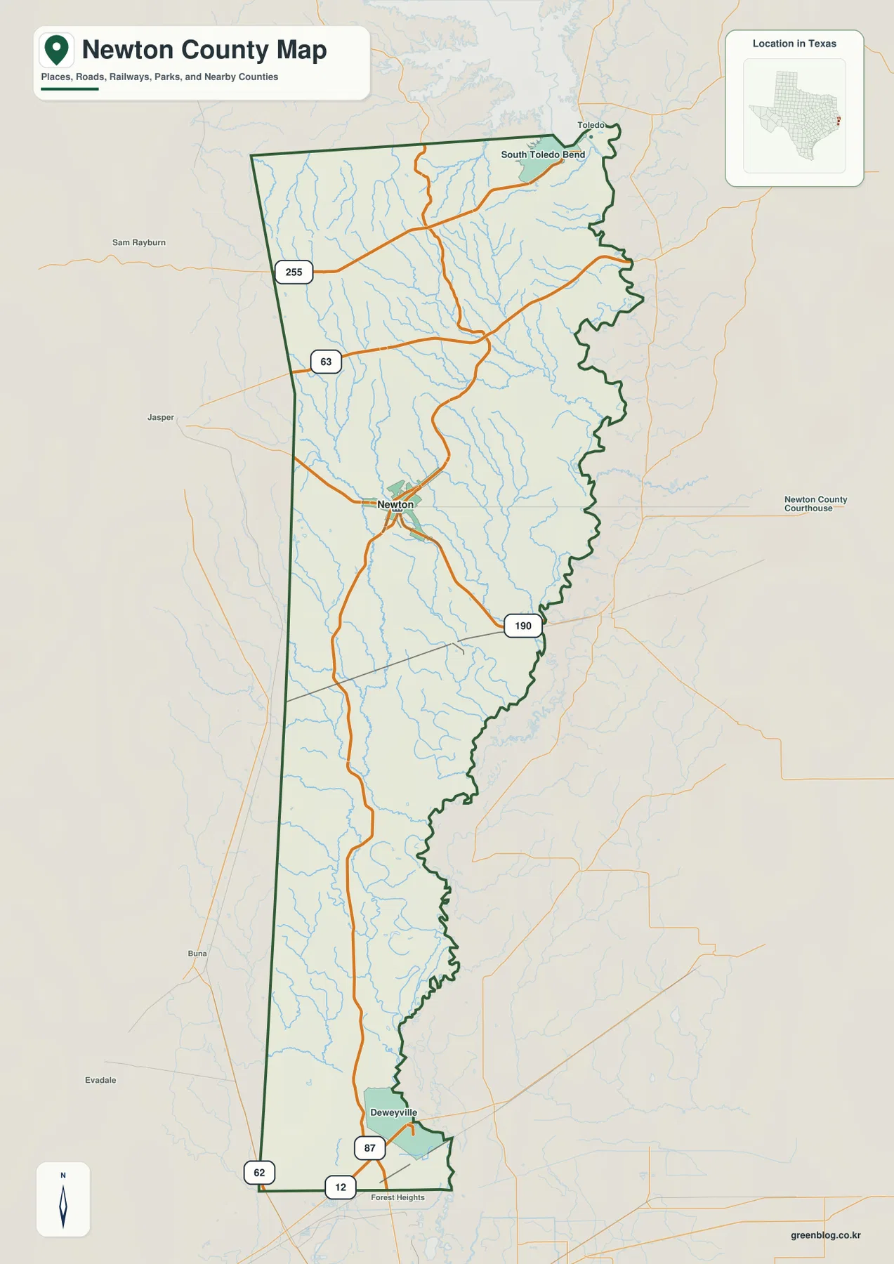
Newton is the clearest settlement label on the general county map. Route 63 approaches from the west, while Route 190 extends east toward the Sabine boundary. Route 255 provides an important northern reference and helps locate the upper half of the county. Starting with those roads makes the narrow, elongated county easier to navigate before looking at the much denser stream network.
South Toledo Bend appears in the northeast close to Toledo Bend Reservoir. The eastern county line becomes highly irregular in this area because it follows the reservoir and Sabine system rather than a surveyed straight line. Toledo is labeled outside the northern side as a regional reference, while Jasper appears west of the county.
South of Newton, major settlement labels become sparse until Deweyville appears near the lower part of the county. Route 87 runs through the Deweyville area and Route 12 provides an additional southern reference. Forest Heights lies near the lower edge. The farther south the map goes, the less dominant the upland road pattern becomes and the more important the river and creek corridors are for understanding location.
The ranked city layer contains only Newton
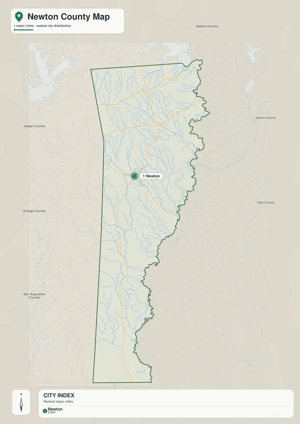
The city map differs from many county connection maps because it identifies only one major city. Newton is ranked number 1, and the lower CITY INDEX prints the value 2,534 beside the name. The supplied image does not show a year for that number, so this article treats it only as a value printed on the map rather than a confirmed current population count.
That single ranked marker is useful in its own way. It emphasizes how much of Newton County lies outside a large-city pattern. Deweyville, South Toledo Bend, and Forest Heights remain useful place references on the general map, but the ranked city layer leaves most of the long county open, allowing the road and drainage structure around Newton to stand out.
Jasper County is labeled to the west, Sabine County to the northeast, Tyler County farther east, and Orange and San Augustine counties around the southwestern and western sides. The Sabine boundary also separates Newton County from Louisiana. These surrounding references help place the single Newton marker within the much larger regional geography.
Toledo Bend Reservoir and northern creeks shape the upper county
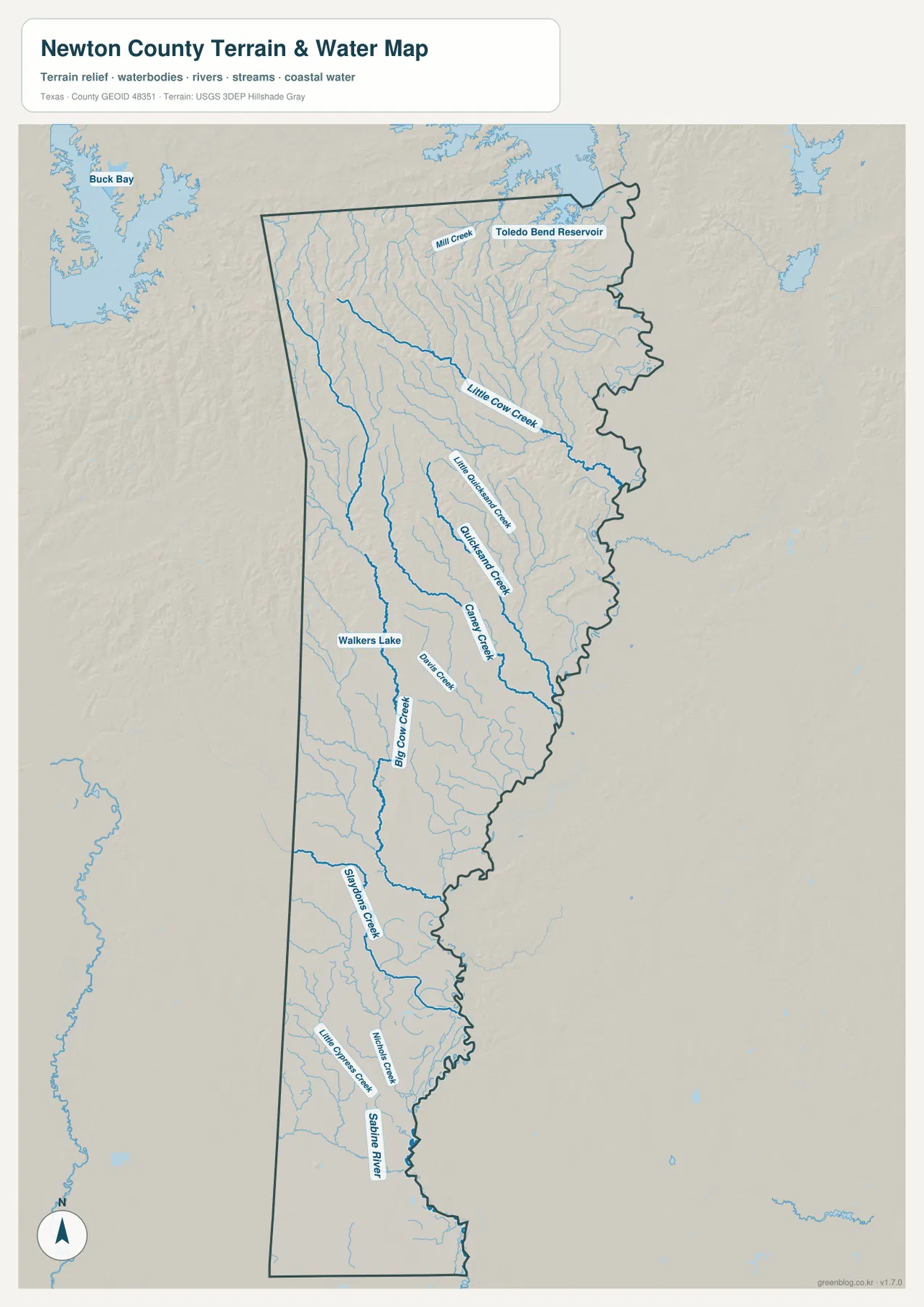
Toledo Bend Reservoir is the strongest water reference in the northeast. Its edge meets the upper Newton County boundary near South Toledo Bend, and the irregular shoreline helps explain the complex shape of the county line. Mill Creek is labeled near the reservoir, while Little Cow Creek forms a longer drainage farther south.
Little Beecham Creek lies below the Little Cow Creek system. Quicksand Creek and Caney Creek form two longer central drainage lines farther south. These named waterways show that the upper county is not simply a continuous forested upland; many creek valleys divide the ridges and descend toward the eastern Sabine system.
Sabine River defines the eastern border and the low southern drainage
Sabine River is the key boundary feature along the eastern side. It follows a winding course from the Toledo Bend area through the middle and lower county, creating the deeply indented edge visible on every map. Numerous western tributaries feed toward the river, so the county’s outline and its drainage are closely connected.
Walkers Lake is labeled in the west-central interior. Davis Creek and Big Cow Creek occupy nearby drainage corridors, while Graybow Creek continues farther south. Little Cypress Creek and other small channels appear in the lower county near the Sabine side. The southern map therefore looks flatter than the north but remains strongly organized by water.
The terrain-and-water layer is best used to match Toledo Bend Reservoir, Sabine River, and the named creeks to Newton and Deweyville. It should not be treated as a legal boundary, flood-hazard, parcel, or navigation product. When access matters, locate the water feature first and then return to the general map to compare it with Route 190, Route 87, and the nearby settlements.
Rugged northern ridges descend toward the Sabine and lower southern county
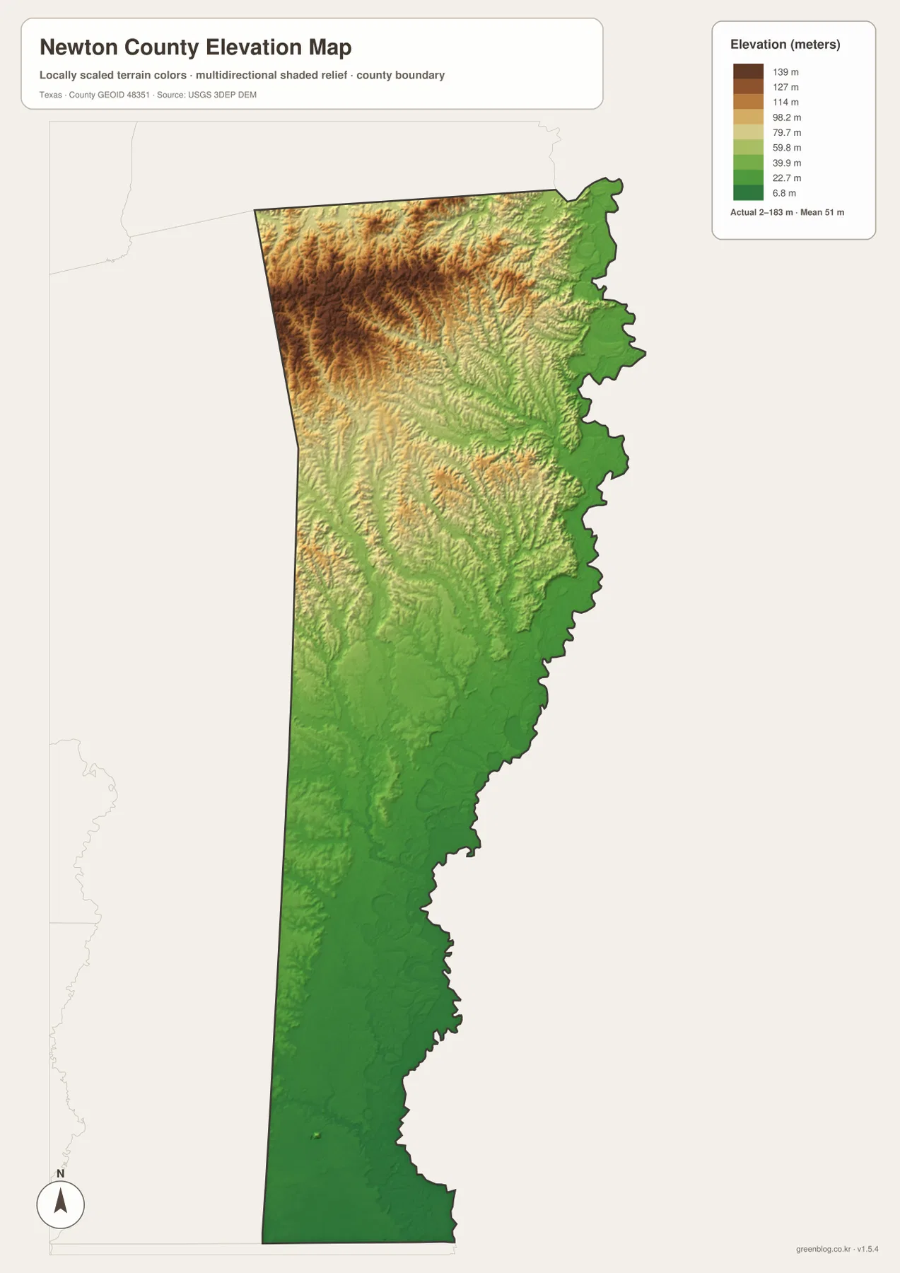
The elevation map reports an actual range of about 2 to 183 meters and a mean elevation of about 51 meters. The strongest brown terrain is concentrated in the northwest and north-central interior. The eastern boundary and most of the southern half are green and much lower, creating a pronounced north-to-south and west-to-east relief change.
The upper ridges are deeply cut by drainage. Little Cow Creek, Quicksand Creek, Caney Creek, and neighboring tributaries occupy green corridors between tan and brown high ground. Even near Toledo Bend Reservoir, the boundary lowland rises quickly toward the interior, producing a hill-and-valley pattern rather than one flat lakeside surface.
Newton occupies intermediate terrain compared with the highest northwest and the lowest southern edge. Moving toward Deweyville and Forest Heights, green colors become more continuous and the landscape flattens. The difference between the displayed minimum and maximum elevation is about 181 meters, a large local range for this part of East Texas.
The elevation layer is most useful for comparing Newton, South Toledo Bend, Deweyville, the northern ridges, and the Sabine lowlands. It is not survey-grade elevation data for individual sites, but it clearly shows why the upper county appears rugged while the lower county is broad and low.
North and south of Newton tell two different terrain stories
Move north from Newton toward Routes 255 and 63 and the land becomes more rugged. The water map adds Little Cow Creek, Quicksand Creek, and Caney Creek to that same area, while the elevation layer shifts into stronger tan and brown ridges. The road map alone does not make this northern relief nearly as obvious.
Move south toward Deweyville instead and the pattern reverses. Elevation drops into broad green lowlands, Sabine River remains close to the eastern side, and smaller creeks cross a flatter landscape. This contrast gives Newton County a more specific map identity than a simple “Newton and Sabine River” description.
A practical reading order is to locate Newton and the main roads first, match Toledo Bend Reservoir, Sabine River, and the named creek corridors to the same positions, and then compare the elevation layer. Small labels such as Mill Creek and Little Beecham Creek are often easier to inspect in the downloadable high-resolution JPG files than in the browser previews.
Frequently Asked Questions
Which city is ranked on the Newton County city map?
Newton is the only ranked major city on the supplied city map. The index also prints 2,534 beside the name, but no year is shown, so this article does not present that value as a confirmed current population count.
Which water features are the best starting points?
Start with Toledo Bend Reservoir in the northeast and Sabine River along the eastern border. Little Cow Creek, Quicksand Creek, Caney Creek, Big Cow Creek, and Graybow Creek then provide more detailed references through the interior and southern county.
What elevation range is shown for Newton County?
The supplied elevation map reports an actual range of about 2 to 183 meters and a mean elevation of about 51 meters. The northwest and north are much higher, while the southern county and much of the Sabine River border occupy lower terrain.
Sources and Reference Data
- U.S. Census Bureau TIGER/Line Shapefiles — official county-boundary and road geometry for geographic reference.
- USGS National Hydrography — official resources for rivers, creeks, reservoirs, and other water features.
- USGS 3D Elevation Program — official elevation resources used for terrain information.
- USGS The National Map Viewer — an official viewer for comparing boundary, water, and terrain layers.
Map File Information
Download four high-resolution A3 JPG maps of Newton County, Texas, in one ZIP file.
- Included Files: county map, ranked city map, terrain and water map, elevation map
- File Type: JPG
Related Maps
- Orange County Texas map
- Angelina County Texas map
- Sabine County Texas map
- San Augustine County
- Tyler County Texas map
Green Map creates custom-edited map images using open geographic data sources such as geoBoundaries, Natural Earth, OpenStreetMap, and government open data.
These maps are edited visual materials, not raw data files, and are provided for education, documents, presentations, and graphic reference.