Clay County sits along Tennessee’s northern edge at the Kentucky line, with Celina serving as the county seat and the main urban reference on the supplied maps. The county is shaped as much by water and ridges as by roads: Dale Hollow Lake spreads across the east, the Cumberland River bends through the central and southern part of the county, and several state routes converge near Celina. High-resolution A3 JPG versions of the county, city, water, and elevation maps are available in the ZIP download on this page.
The 2020 census counted 7,581 residents in Clay County, while the Census Bureau’s July 2025 estimate is 7,821. Gazetteer figures list about 236.5 square miles of land and 22.8 square miles of water. That water area is not just a statistic: the map makes its importance obvious through the long arms of Dale Hollow Lake, the Cordell Hull Reservoir area, and the Cumberland River valley. Reading those features together with Celina and the road network gives a much clearer picture of the county than treating the boundary as an empty outline.
Table of Contents
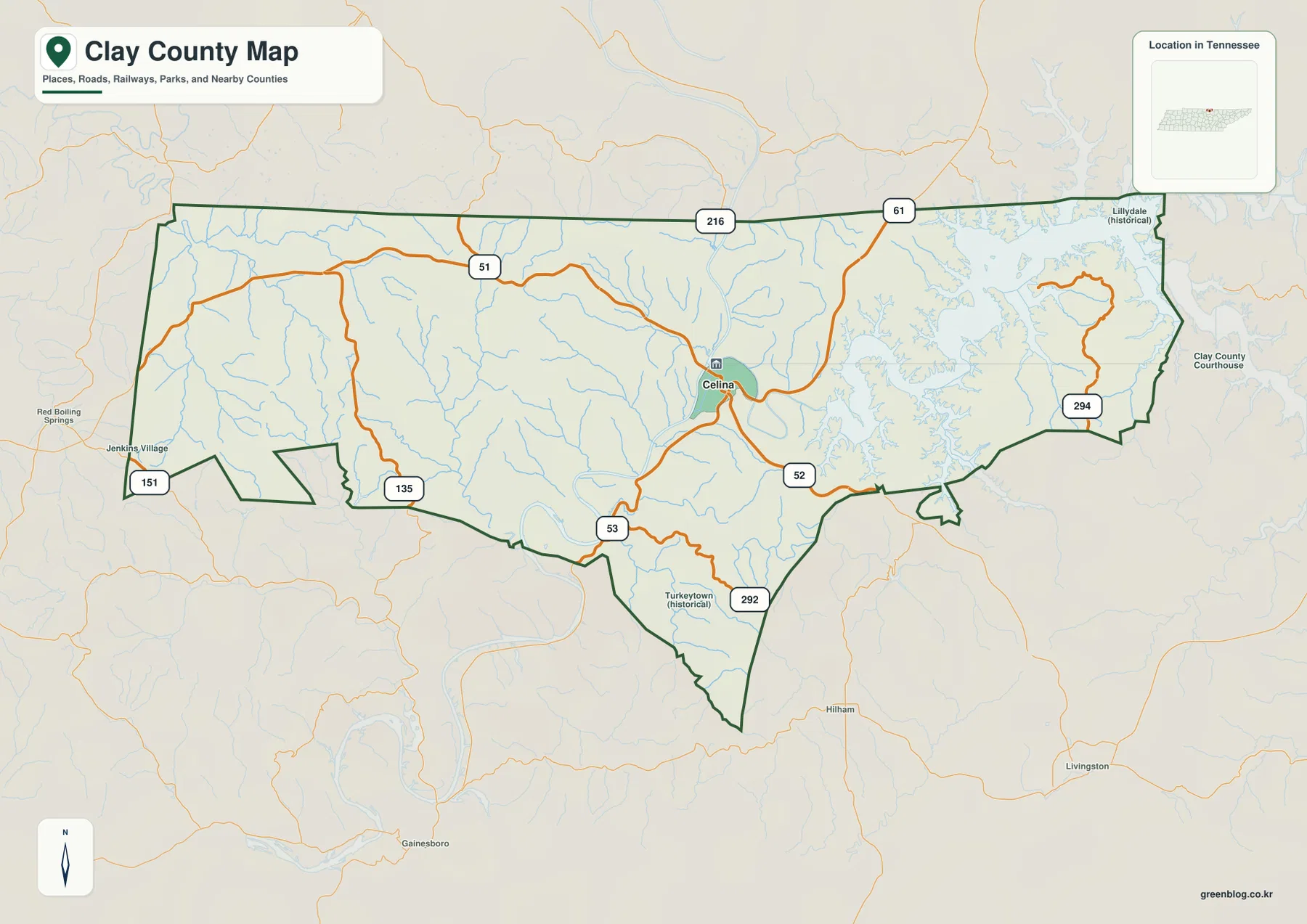
Celina is the main reference point for roads and county orientation
On the general county map, Celina stands slightly east of center and is marked as the administrative seat. Several numbered routes meet or pass close to it. Route 51 continues west, 52 heads toward the southeast, and 61 provides a connection toward the northeastern side of the county. Farther south, 53 and 292 follow the narrowing lower portion of the county, while 294 appears near the eastern lake area. The pattern is easier to understand when the roads are read outward from Celina rather than as an isolated list of route numbers.
The northern boundary is the Tennessee-Kentucky state line. Routes 216 and 61 cross the northern part of the map, while 151 and 135 appear toward the west and southwest. Historical labels such as Lillidale and Turkeytown are also shown, adding useful location references beyond the present-day county seat. Together, the boundary, place labels, and route network show a county whose travel corridors are separated by water valleys and rolling uplands rather than arranged in a simple grid.
The city map emphasizes one principal community: Celina
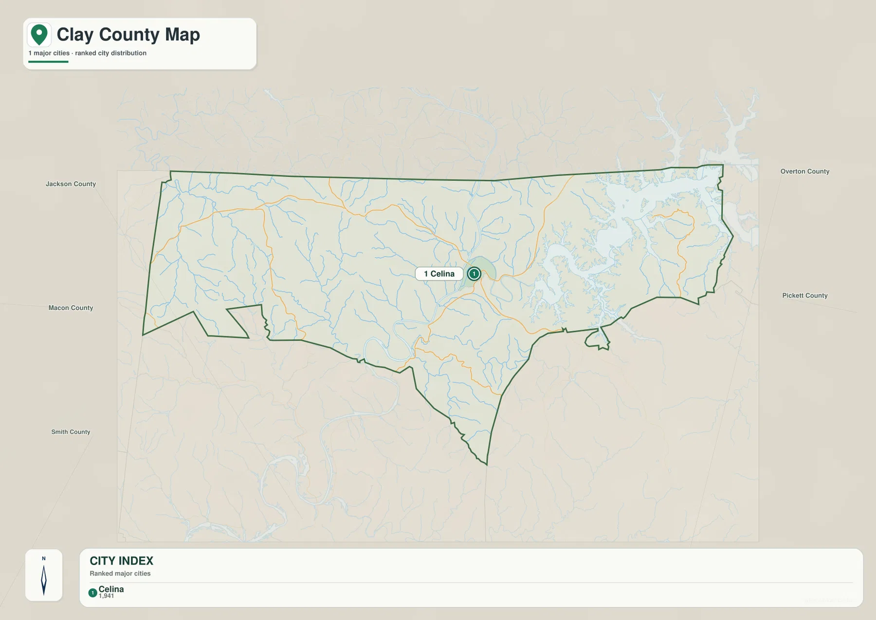
The ranked city map identifies Celina as the single major city included in its index, with a displayed population of 1,941. That does not mean Clay County has no other settlements or named places. It means this particular city-distribution map highlights only one community under its ranking method. For that reason, the map is more useful for establishing the county’s administrative and population reference point than for comparing several large urban centers.
Neighboring county labels help place Celina in a wider regional setting. Jackson County, Macon County, and Smith County appear to the west and southwest, while Overton County and Pickett County lie to the east. The Kentucky line forms the northern side of Clay County, so roads and waterways near that edge naturally continue beyond Tennessee. Keeping those surrounding jurisdictions in view helps prevent a road, creek, or edge community from being mistaken for a feature entirely contained within Clay County.
Dale Hollow Lake and the Cumberland River define the water landscape
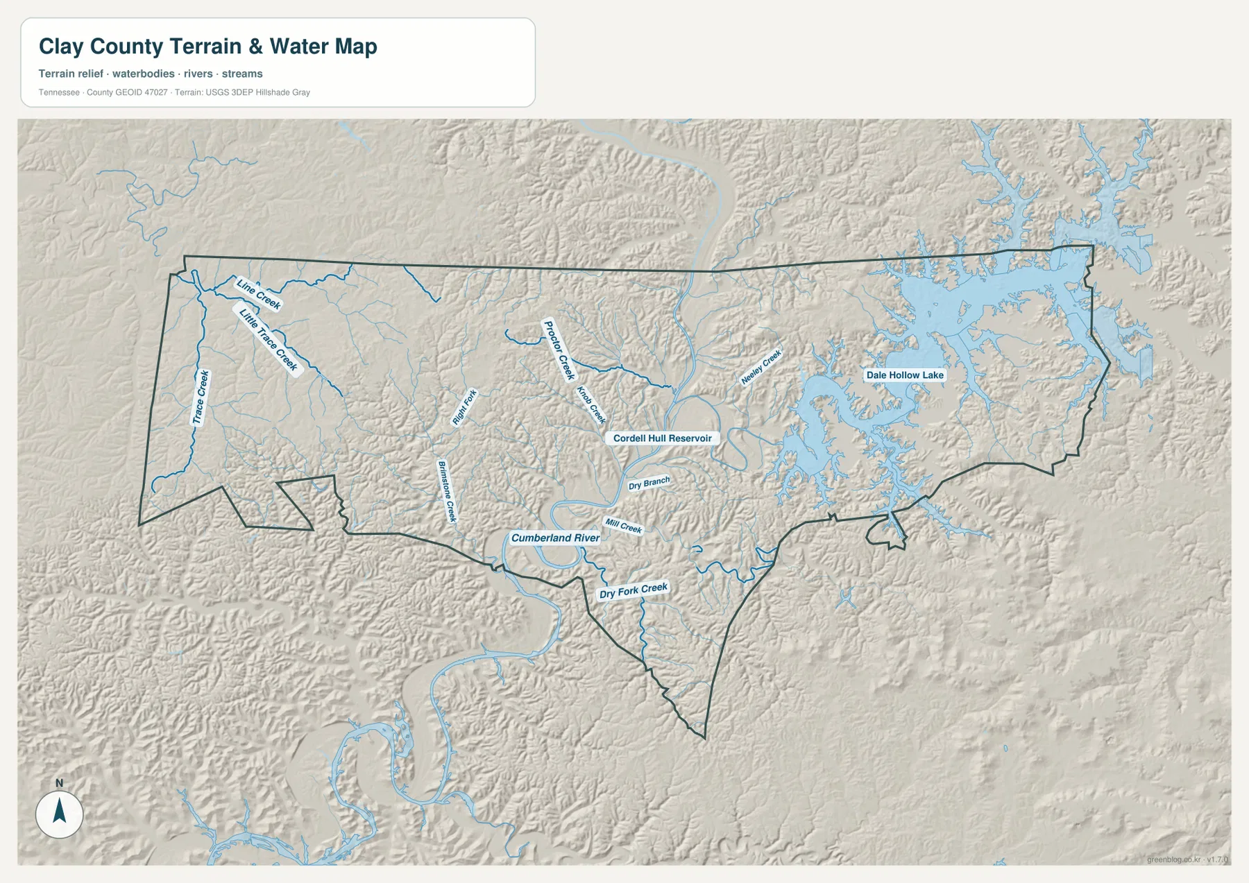
The eastern side of the water-and-terrain map is dominated by Dale Hollow Lake. Its shoreline branches into numerous narrow arms and valleys, creating a much more complex shape than a simple lake outline. Near the center, the Cordell Hull Reservoir label appears along the larger river corridor, and the Cumberland River continues west and south in broad bends. These water bodies are central to understanding why nearby places can have indirect road connections even when they look close together on a county-scale map.
Smaller streams reveal the drainage pattern in more detail. Line Creek, Little Trace Creek, and Trace Creek are labeled in the west. Proctor Creek, Knob Creek, and Brimstone Creek appear closer to the central part of the county, while Neeley Creek runs toward the Dale Hollow Lake side. Dry Branch, Mill Creek, and Dry Fork Creek are shown in the southern area. These labels are best used as terrain references; the map is not intended to determine flood risk, navigability, or legal water boundaries.
Dale Hollow Lake and the Cumberland River also create two visually different water settings. The lake spreads through many branching coves in the east, whereas the river and reservoir corridor is longer and narrower through the center and south. Comparing those forms helps explain the contrasting road patterns nearby. Some roads follow valleys, others bend around higher ground, and crossings occur only at selected points rather than wherever two places are closest in a straight line.
Low river valleys are surrounded by higher ridges and rolling uplands
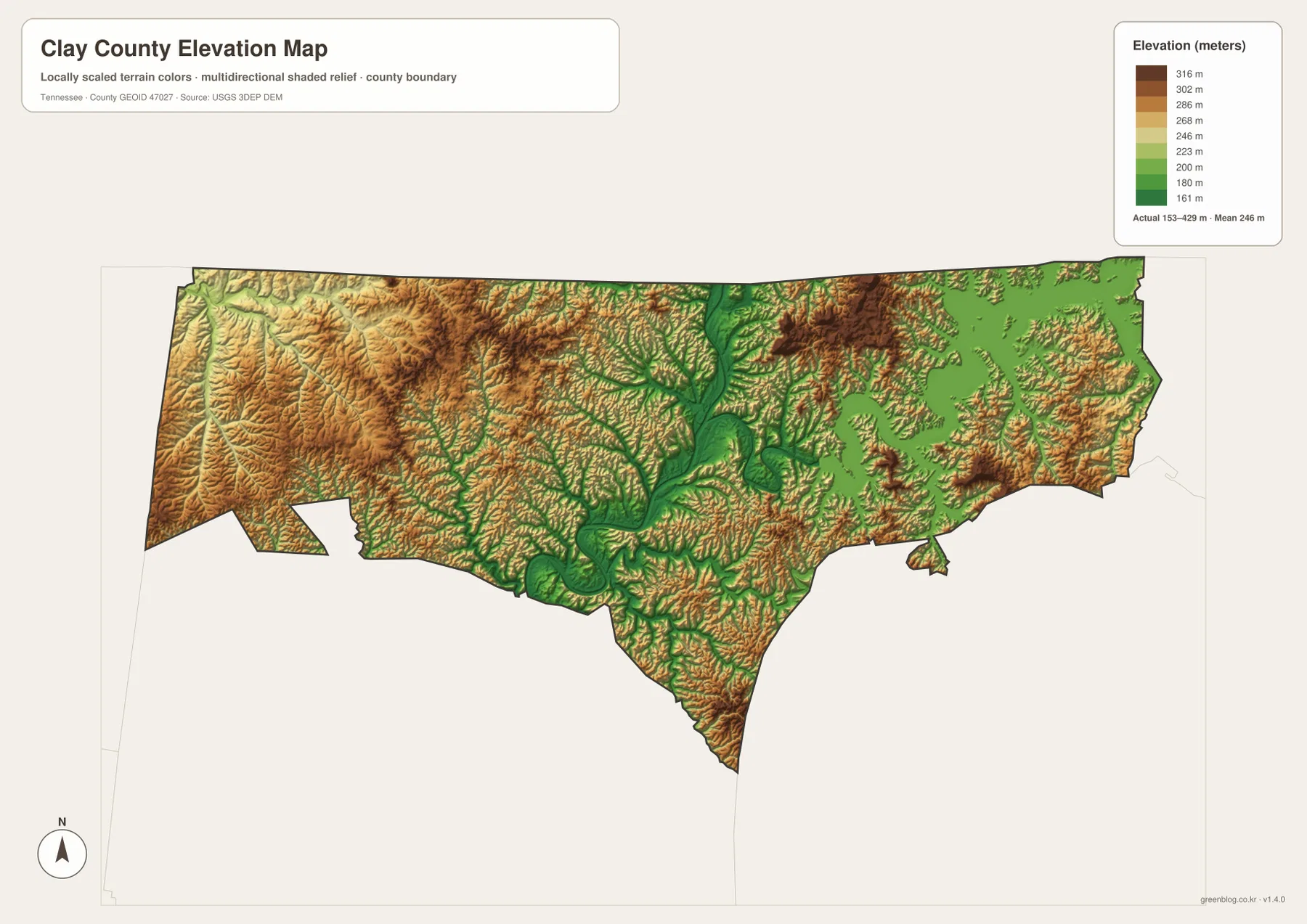
The elevation map reports an actual range of roughly 153 to 429 meters, with a mean near 246 meters. Lower elevations follow the Cumberland River and reservoir valleys, forming long green corridors through the county. Higher terrain appears in the western uplands and in ridges around the northeastern and eastern sections. Instead of one steady rise from one side to the other, Clay County shows repeated ridges separated by stream-cut valleys.
Around Dale Hollow Lake, the shoreline lies low while narrow ridges remain between the lake’s branching arms. In the central county, the Cumberland River valley creates one of the clearest low-elevation pathways. To the west, smaller streams dissect the higher ground into a dense pattern of valleys and hills. That relationship helps explain why the road network frequently bends with the terrain instead of following long straight lines.
This elevation surface is designed for county-scale comparison, not engineering or survey work. It is useful for seeing where the major valleys and higher ridges are, but it should not be used as the exact elevation of a parcel, building site, trail point, or road grade. For precise measurements, readers should consult current USGS elevation data or an appropriate surveying source.
Population and area figures make more sense beside the maps
Clay County’s 2020 census population was 7,581, and the July 2025 estimate is 7,821. Because one is a decennial census count and the other is an estimate, they should remain clearly labeled rather than being treated as interchangeable totals. Using the 236.5 square miles of land, the 2020 population works out to an average density of about 32.1 residents per square mile.
That countywide average does not describe every part of Clay County equally. Celina is the only major city highlighted on the supplied city map, while the eastern part of the county contains extensive lake shoreline and the rest of the county is broken by valleys, ridges, and smaller communities. Population figures become more informative when they are read together with settlement locations, road access, and the physical constraints shown on the other maps.
Clay County was established in 1870, with Celina serving as the county seat. The maps here are not historical boundary maps, but that administrative background explains why Celina appears repeatedly as the main orientation point. When the seat, major waterways, route network, and surrounding county boundaries are considered together, the page provides a practical overview of how the county is organized today.
Which Clay County map is most useful for your task?
For a quick location overview, the general county map is the best starting point because it combines Celina, numbered roads, county boundaries, and the Dale Hollow Lake area. The city map is useful when the goal is to establish Celina as the principal urban and administrative reference and then compare its position with the surrounding counties.
For physical geography, the water-and-terrain map provides the clearest view of Dale Hollow Lake, Cordell Hull Reservoir, the Cumberland River, and named tributaries. The elevation map answers a different question by showing where low valleys and higher ridges occur. Comparing the water and elevation views is especially helpful because the river and lake corridors line up with many of the county’s lowest areas and help explain the shape of nearby roads.
Frequently Asked Questions
Where are Dale Hollow Lake and the Cumberland River in Clay County?
Dale Hollow Lake dominates the eastern side of the county, with many branching coves extending into the surrounding ridges. The Cumberland River bends through the central and southern sections, and the Cordell Hull Reservoir label appears along that broader river corridor. Locating these water features first makes the road and terrain patterns much easier to follow.
Why does the city map show only Celina as a major city?
The supplied city-distribution map ranks Celina as the single major city and lists a population of 1,941. This does not mean there are no other communities in Clay County; it reflects the ranking method used for this particular map. Other settlements and historical labels are better viewed on the general county map.
Can the elevation map be used for surveying or engineering?
No. The map is intended to compare broad county-scale elevation differences, including the roughly 153–429 meter range and the contrast between river valleys and ridges. Parcel elevations, construction grades, trail measurements, and engineering decisions require current detailed elevation or survey data.
Map File Information
The ZIP contains high-resolution JPG versions of the Clay County reference, city, water-and-terrain, and elevation maps. Use the larger originals for A3 printing, classroom materials, location notes, or personal map annotations.
- Included Files: 4 high-resolution JPG maps
- File Type: JPG images in a ZIP archive
Related Maps
Sources and References
County boundaries and basic geographic reference data can be checked with the U.S. Census Bureau TIGER/Line files. Population and area figures are supported by U.S. Census Bureau QuickFacts and the Gazetteer Files. For Dale Hollow Lake, readers can consult the Tennessee Wildlife Resources Agency, while county-history background is available from the Tennessee State Library and Archives.
Green Map creates custom-edited map images using open geographic data sources such as geoBoundaries, Natural Earth, OpenStreetMap, and government open data. These maps are edited visual materials, not raw data files, and are provided for education, documents, presentations, and graphic reference.