Evans County is a compact southeastern Georgia county centered on Claxton, with Hagan, Daisy, and Bellville close enough to compare easily on a single map. This page brings together four views of the same county: a general boundary-and-road map, a city connection map, a water map, and an elevation map. The maps show different details without forcing everything into one crowded image. After reviewing the previews, you can download one ZIP containing four high-resolution A3 JPG files for printing, classroom use, presentations, local research, or reference work.
The county’s geography becomes clearer when the four views are read together. Claxton sits near the middle of the main road network, while Hagan and Bellville extend west and Daisy lies to the east. The water map adds the Canoochee River, Cedar Creek, Bull Creek, and many smaller drainage lines. The elevation map then shows why those waterways matter: the county ranges from about 16 to 70 meters in elevation, with broad low corridors following major stream valleys. This combination of towns, roads, water, and relief gives a more useful picture than the boundary alone.
Table of Contents
Claxton at the Center of the Evans County Road Network
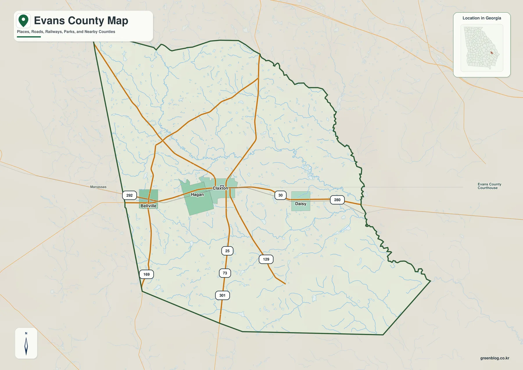
The general map makes Claxton the natural point of orientation. Hagan is immediately west of the county seat, Bellville lies farther west, and Daisy is east of Claxton. Those four places create an easy east-west reference across the middle of the county. Manassas is labeled just beyond the western boundary, and an Evans County Courthouse label appears to the east as an additional location cue. The county outline itself is relatively compact but becomes more irregular toward the east and southeast.
Several numbered routes help organize the map. Routes 280 and 30 form a strong east-west reference through the Claxton–Daisy corridor, while 301, 25, and 73 help define north-south movement through the central and southern part of the county. Routes 292 and 169 are visible toward Bellville and the western side, and 129 runs southeast from the Claxton area. The map is useful for seeing how those roads relate to towns and the county boundary, but it is not a street-level navigation product and does not attempt to show every intersection or local road.
Water is visible even on the general map. Numerous light-blue tributaries cross the northern half, the Claxton area, and the southern interior. That density matters because the county is not simply a flat block crossed by highways. Streams occupy many of the lower corridors between slightly higher ridges. The dedicated water and elevation maps make those relationships easier to see, so the general map works best as the starting overview before moving into physical geography.
Straight-Line Connections from Claxton to Hagan, Daisy, and Bellville
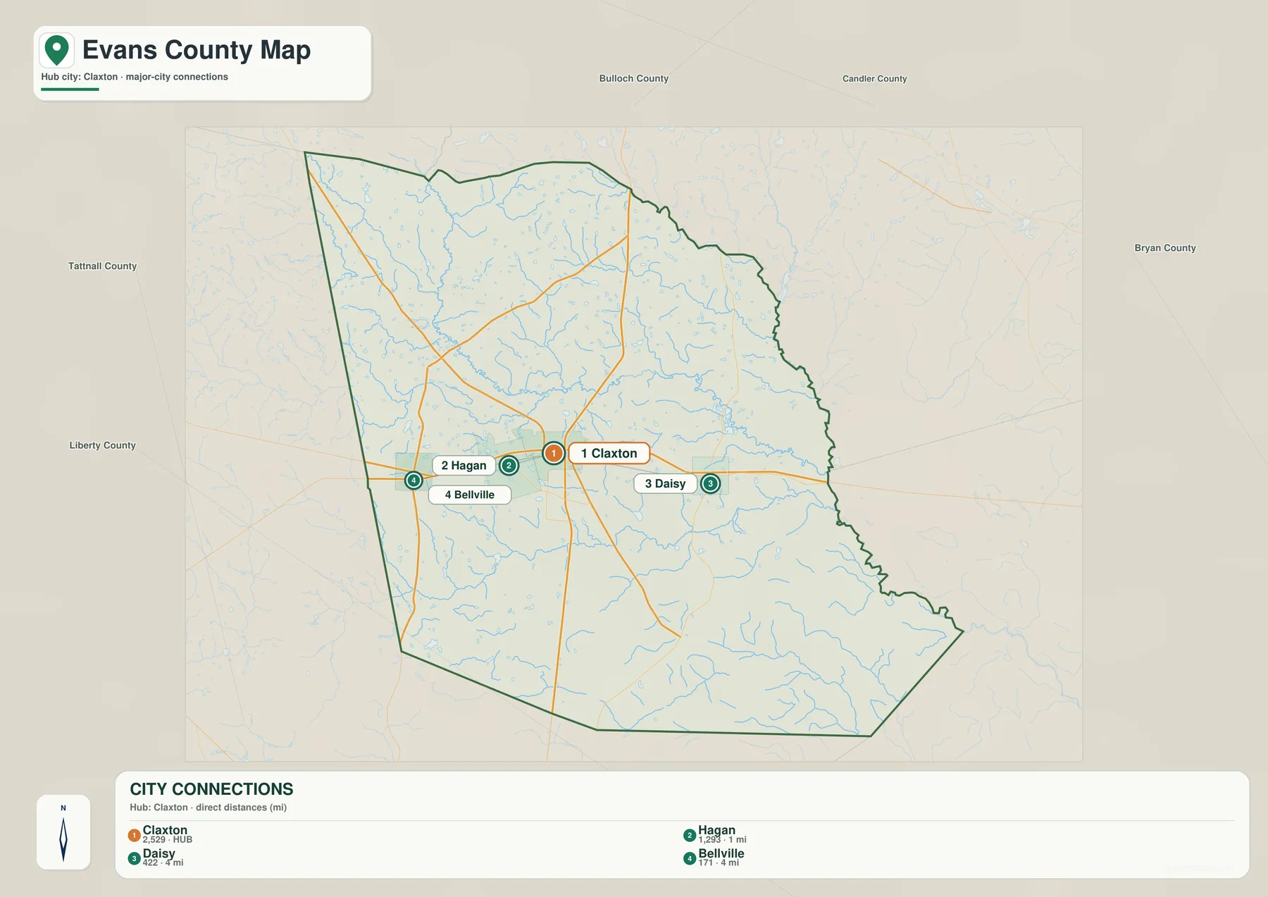
The city map removes much of the extra detail and focuses on four places. Claxton is the hub. Hagan is shown about 1 mile away, while Daisy and Bellville are each shown about 4 miles from Claxton. These are straight-line distances on the supplied city map, not driving distances. A road route may be longer because it follows the street network rather than a direct line, so the figures are best used to compare relative closeness rather than to estimate travel time.
The same map includes a ranking panel with Claxton at 2,529, Hagan at 1,293, Daisy at 422, and Bellville at 171. Those values are part of the supplied map and explain why Claxton is emphasized as the hub; they are not being presented here as a new population estimate. Readers who need the latest official population figures should use the current Census source linked near the end of the page.
The surrounding county labels provide regional orientation without adding clutter to the town connection lines. Bulloch County is shown to the north, Candler County to the northeast, Bryan County to the east, Tattnall County to the west, and Liberty County to the southwest. Because Evans County is relatively small, these surrounding names make it easier to place Claxton and the other three cities within southeastern Georgia rather than viewing them as isolated points.
| City | Position relative to Claxton | Straight-line distance shown |
|---|---|---|
| Claxton | Hub | Reference point |
| Hagan | Immediately west | About 1 mile |
| Daisy | East | About 4 miles |
| Bellville | West, beyond Hagan | About 4 miles |
Canoochee River, Creeks, Ponds, and Millponds
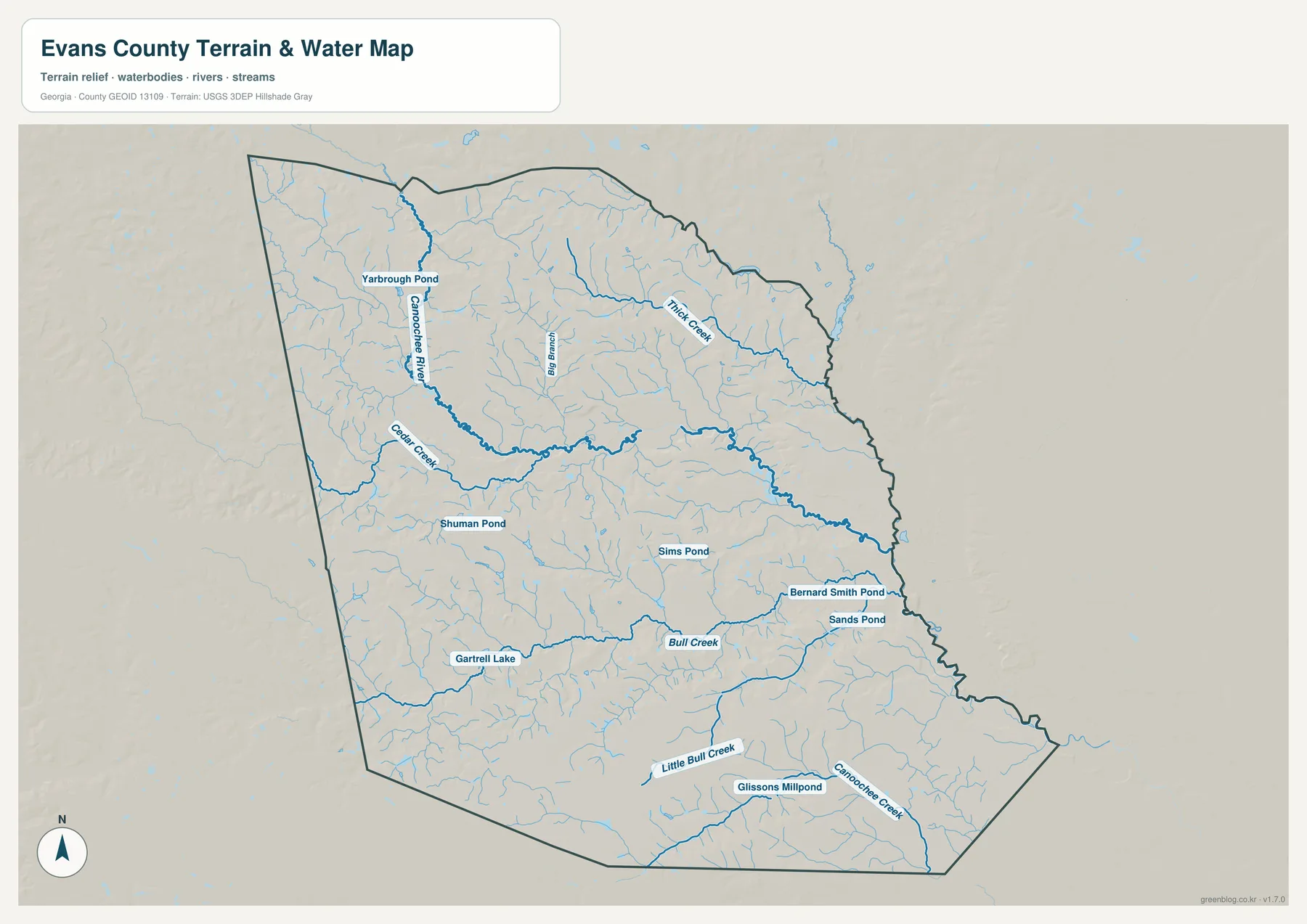
The Canoochee River is one of the strongest water features on the map. It enters from the northwest and crosses the county through a broad central valley before continuing toward the east. Cedar Creek connects on the western side, while Thick Creek is labeled in the northeast. Big Branch appears north of the main river, and the southern half contains Bull Creek, Little Bull Creek, and Canoochee Creek. A dense web of smaller blue lines feeds these named channels, showing that drainage is distributed across the county rather than concentrated in only one stream.
Several ponds and small lakes are also labeled. Yarborough Pond is in the northwestern part of the map, Shuman Pond and Sims Pond lie closer to the center, and Bernard Smith Pond and Sands Pond appear toward the east. Gartrell Lake is marked in the southwest, while Glissons Millpond is farther south. These labels are useful local reference points, not a complete inventory of every pond or wet area in Evans County.
This map is intended to show the position and connections of waterways at county scale. It should not be used to decide whether a parcel is in a flood zone, to establish a legal water boundary, or to determine navigability. For those questions, specialized and current regulatory data is required. The water map is most effective when paired with the elevation view, because the main river and creek corridors generally follow lower ground.
A 16–70 Meter Elevation Range Shaped by Stream Valleys
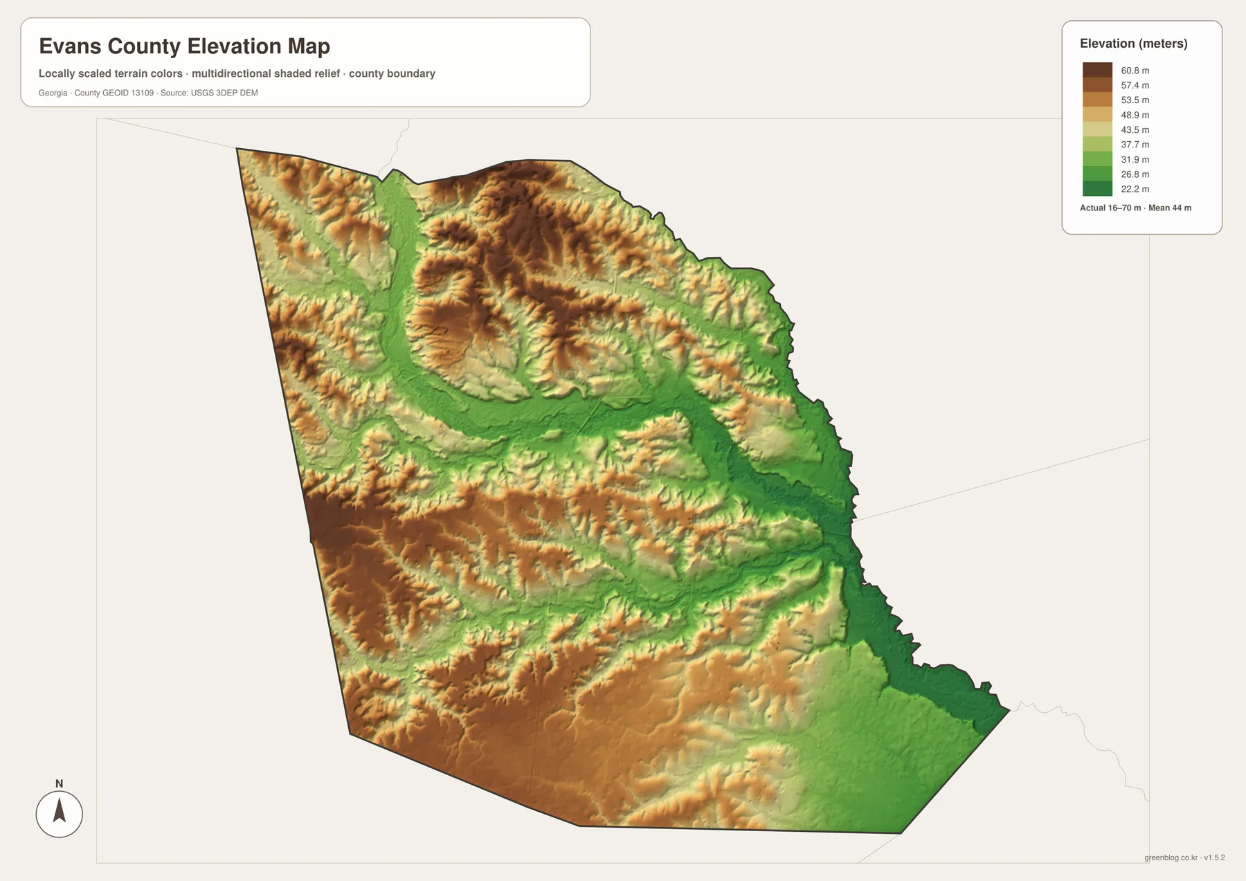
The elevation legend reports an actual range of about 16 to 70 meters and a mean of 44 meters. That is a modest range compared with mountain counties, but the shaded relief still reveals a clear internal pattern. Brown and tan ridges occupy parts of the west, southwest, and northern interior, while broad green corridors mark lower ground through the center and toward the eastern and southeastern edge.
The most obvious low corridor matches the Canoochee River system. A green valley enters from the northwest, widens through the central part of the county, and continues eastward. Smaller green branches extend into tributary valleys, while the land between them rises into short, rolling ridges. The southeastern boundary also falls into lower terrain. Reading the elevation and water maps side by side makes the relationship between streams and topography much easier to understand.
The elevation surface is generalized for county-wide comparison. It is not survey-grade information for a building site, road design, drainage calculation, or engineering project. Exact work at a specific location requires a more detailed elevation dataset or field survey. For geography lessons, county descriptions, or a presentation about why rivers occupy certain corridors, however, the map provides a clear visual summary of Evans County relief.
Reading the County Through Towns, Roads, and Low Ground
The four maps answer different parts of the same geographic question. The general map shows where Claxton, Hagan, Daisy, and Bellville sit within the county and which numbered roads connect the area. The city view strips away detail so their spacing is obvious. The water map reveals a much denser landscape of rivers, creeks, ponds, and smaller tributaries, while the elevation map explains why those water features occupy broad low corridors.
The current article material identifies Evans County as having been established in 1914 and notes rail development, agriculture, and poultry as part of its local background. The maps on this page do not directly measure those industries or show present-day rail service. They provide the geographic framework for researching them: Claxton as the county seat, the close spacing of nearby towns, the main road pattern, and the physical landscape around the Canoochee River. The Census and Georgia Department of Community Affairs links below are better sources for current demographic or planning details.
For a classroom project, the general and city maps work well when the topic is settlement and transportation. The water and elevation views are more useful for physical geography. A local-history presentation can start with Claxton and the nearby towns, then add the Canoochee River and surrounding relief to show that the county’s communities sit within a network of valleys rather than on a featureless plain. When a larger image is needed, the downloadable A3 JPGs preserve the four separate views for print and document use.
Frequently Asked Questions
Are the city distances driving distances?
No. The city map labels direct, straight-line distances from Claxton. Hagan is shown at about 1 mile, while Daisy and Bellville are each about 4 miles away. Actual road distance can be longer.
Which waterways are labeled on the water map?
The map labels the Canoochee River along with Cedar Creek, Thick Creek, Big Branch, Bull Creek, Little Bull Creek, and Canoochee Creek. It also names several ponds, a lake, and a millpond.
What elevation range is shown for Evans County?
The supplied elevation map reports an actual range of about 16 to 70 meters and a mean of 44 meters. The map is designed for county-scale terrain comparison rather than site-specific surveying.
What is included in the download ZIP?
The archive contains four high-resolution A3 JPG files: the general county map, city map, water map, and elevation map.
Map File Information
Evans County A3 Map Files
- Included Files: General county, city, water, and elevation maps
- File Type: Four high-resolution A3 JPG files bundled in one ZIP archive
- Intended Use: Printing, education, presentations, and map-based projects
Related Maps
Sources and Reference Material
- U.S. Census Bureau QuickFacts: Evans County – current county statistics
- New Georgia Encyclopedia: Evans County – county history and local background
- Georgia Department of Community Affairs: Evans County Comprehensive Plan – county and city planning context
- USGS National Hydrography – river and stream data
- USGS 3D Elevation Program – elevation data
Green Map creates custom-edited map images using open geographic data sources such as geoBoundaries, Natural Earth, OpenStreetMap, and government open data. These maps are edited visual materials, not raw data files, and are provided for education, documents, presentations, and graphic reference.