Emanuel County sits in southeastern Georgia, where Swainsboro serves as the county seat and a practical starting point for understanding the county. The maps on this page are designed to do more than trace an outline. They show the relationship among towns, numbered roads, rivers and creeks, ponds, and changes in elevation across the county. After reviewing the maps on screen, you can download a ZIP containing four high-resolution A3 JPG files for printing, classroom work, presentations, local research, or any project that benefits from a larger map image.
Swainsboro is the clearest reference point on the general map, but it is only one part of a county that extends toward Twin City and Garfield in the east, Stillmore and Oak Park in the south, Adrian in the west, and Summertown and Canoochee farther north. The water and elevation maps add another layer to that picture. The Ogeechee River appears along the northern part of the county, while the Little Ohoopee River and Ohoopee River form a strong southwest-to-south reference. Those waterways correspond with lower corridors on the elevation map, which makes the county easier to understand as terrain rather than as a flat administrative shape.
Table of Contents
Swainsboro as the Starting Point for Emanuel County
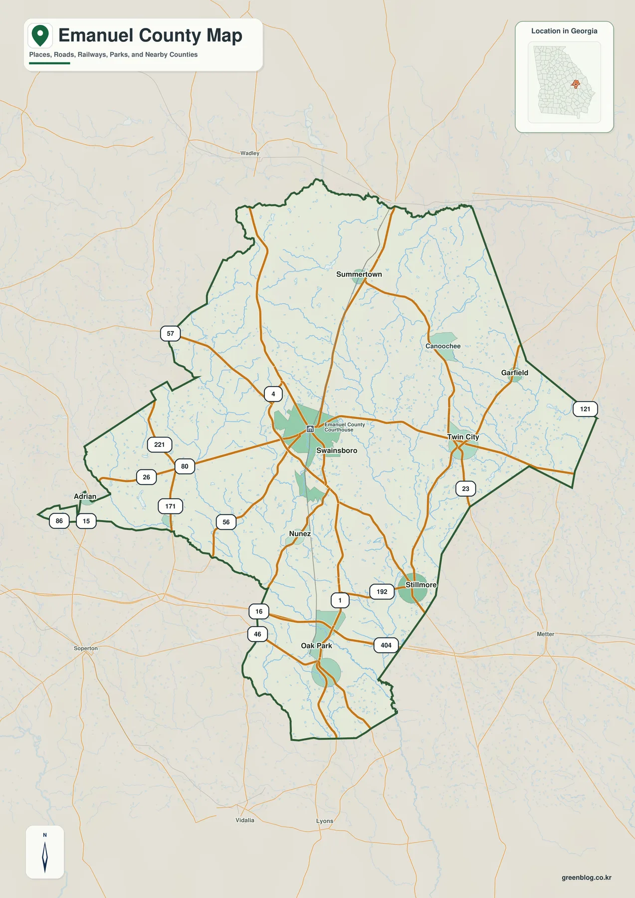
The general county map places Swainsboro near the middle of a broad, irregular boundary. Twin City lies to the east, Stillmore is southeast of the county seat, Oak Park is farther south, and Adrian sits near the narrow western extension. Summertown appears north of Swainsboro, while Canoochee and Garfield provide useful reference points toward the northeast and east. Nunez is shown south of Swainsboro. When the view is extended beyond the county line, places such as Wadley to the northwest, Metter to the east, Lyons and Vidalia to the south, and Soperton to the southwest help establish where Emanuel County fits within southeastern Georgia.
Roads converge around Swainsboro and then spread toward the county edges. The map labels a number of routes, including 1, 4, 16, 23, 26, 46, 56, 57, 80, 86, 121, 171, 192, 221, and 404. These labels are most useful at the county scale: they help a reader follow the direction from Swainsboro toward Twin City, Stillmore, Oak Park, or Adrian and see where important routes intersect. The page is not intended to replace current turn-by-turn navigation, and it does not attempt to show every local street or access point. Its strength is orientation—seeing the county boundary, the main settlements, and the principal road pattern together.
Blue stream lines are also visible on the general map, especially across the northern, central, and southern parts of the county. They remind the reader that the space between towns is not empty. Roads and communities sit among a dense network of drainage lines, and the thicker waterways near the southwest and south become much easier to identify on the dedicated water map later on the page. For that reason, the county map works best as the broad overview before moving to the more specialized city, water, and elevation views.
Six Major Cities Across a Broad Rural County
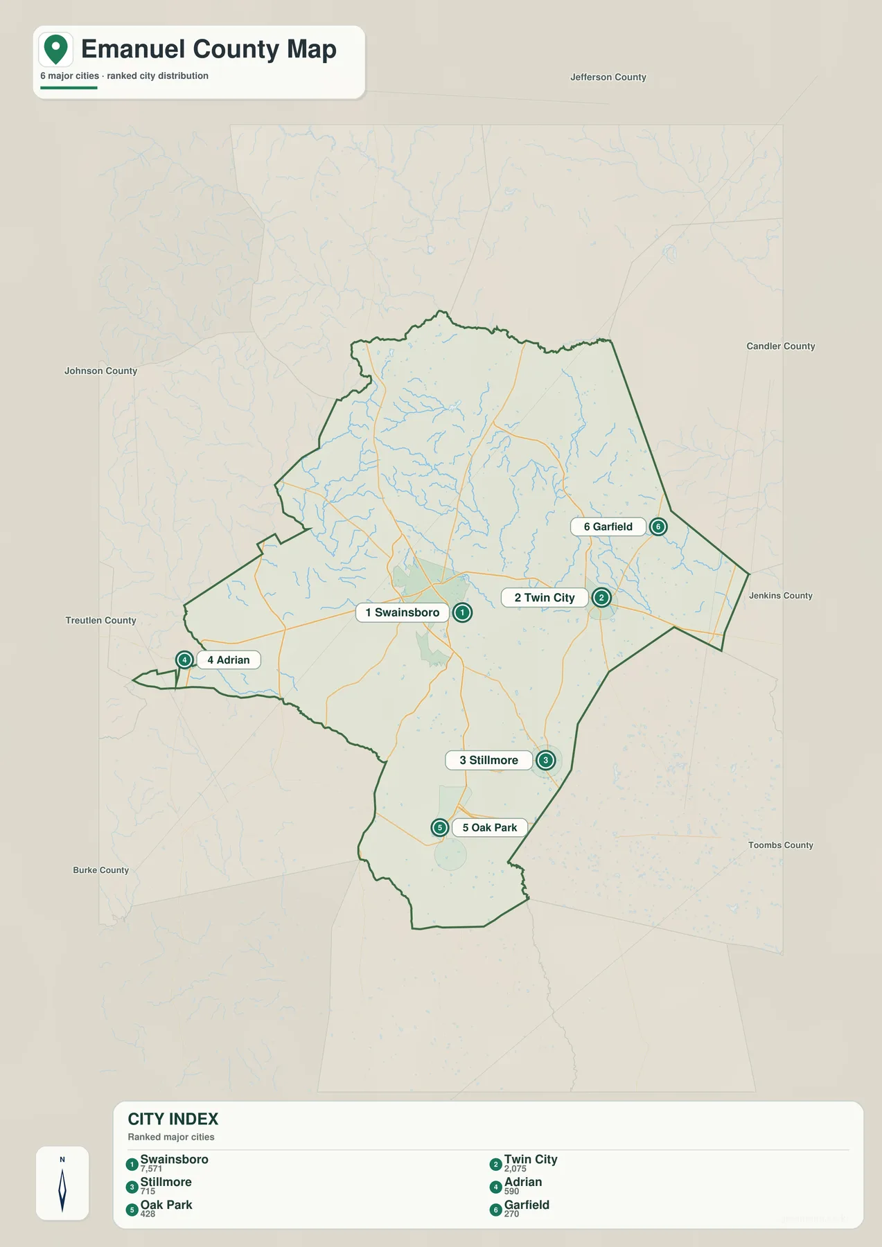
The city map simplifies the county by emphasizing six places rather than every named community. Its index lists Swainsboro at 7,571, Twin City at 2,075, Stillmore at 715, Adrian at 590, Oak Park at 428, and Garfield at 270. Those figures are part of the supplied map and are useful here as a guide to how the map ranks and emphasizes the cities; readers who need the latest official population estimate should consult current Census data in the sources section. The important geographic point is that Swainsboro is the dominant center while the remaining cities are distributed around a much larger rural area.
The pattern is easy to see without following every road. Twin City and Garfield occupy the eastern side, Stillmore and Oak Park are south of the county seat, and Adrian is far to the west. Swainsboro therefore works as a central reference rather than one end of a continuous urban strip. Large spaces remain between the labeled cities, crossed by roads and streams. This arrangement is useful for classroom geography, county-level planning context, local-history orientation, or a presentation that needs to explain why a trip across Emanuel County can involve several distinct small towns rather than a single uninterrupted built-up area.
The surrounding county names on the city map add useful context. Jefferson County is shown to the north, Candler County to the east, Jenkins County toward the southeast, Toombs County to the south and southeast, Burke County to the southwest, Treutlen County to the west-southwest, and Johnson County to the west. The labels help a reader connect the position of Adrian with the western side of the county and the positions of Twin City and Garfield with the eastern side. They are background orientation rather than a substitute for a legal boundary survey, but they make the internal city pattern easier to place within the regional map.
| Map rank | City | Position shown on the city map |
|---|---|---|
| 1 | Swainsboro | Central county seat and main reference point |
| 2 | Twin City | East of Swainsboro |
| 3 | Stillmore | Southern and southeastern part of the county |
| 4 | Adrian | Near the western extension of the county |
| 5 | Oak Park | South of Swainsboro, near major road crossings |
| 6 | Garfield | Northeastern/eastern side near the county edge |
From the Ogeechee River to the Ohoopee System
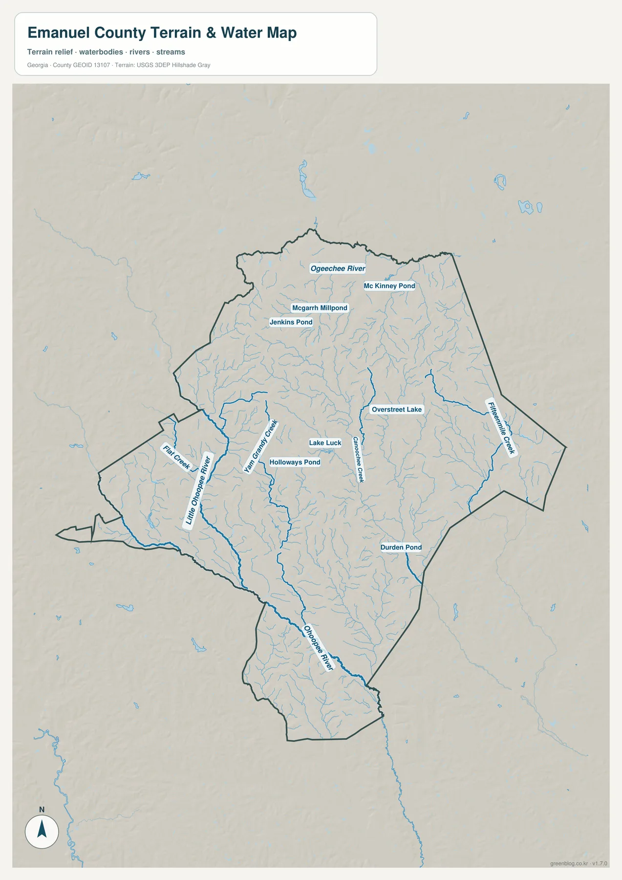
The water map makes several names much clearer than they are on the general county view. The Ogeechee River is labeled along the northern portion of the county. On the western and southwestern side, the Little Ohoopee River becomes a strong linear feature, and the Ohoopee River continues through the southern part of the map. Between those larger rivers is a fine network of tributaries. Flat Creek is labeled in the west, Yam Grandy Creek and Canoochee Creek appear through the interior, and Fifteenmile Creek is shown toward the east. Together they show that Emanuel County is crossed by many small drainage lines rather than being organized around a single river.
Named ponds and lakes provide additional local reference points. Jenkins Pond, McGarrh Millpond, and Mc Kinney Pond appear in the northern half; Holloways Pond and Lake Luck are closer to the center; Overstreet Lake is farther east; and Durden Pond is marked in the southeast. These are not presented as a list of recreational destinations. On this map their primary value is geographic: they help locate smaller waters within the creek network and make it easier to compare one part of the county with another. Numerous unnamed blue lines connect the labeled features, giving a good sense of how dense the local drainage network is.
This water view should be read as a county-scale reference, not as a flood-risk, parcel, navigation, or legal water-boundary product. A blue line shows the mapped position of a water feature, but it does not tell a property owner whether a particular lot is in a regulatory flood zone or whether a channel is navigable. For those questions, a specialized current source is required. The map is particularly effective when paired with the elevation view because the larger river corridors generally correspond to lower ground, allowing the reader to connect named waterways with the shape of the terrain.
Elevation from About 38 to 125 Meters
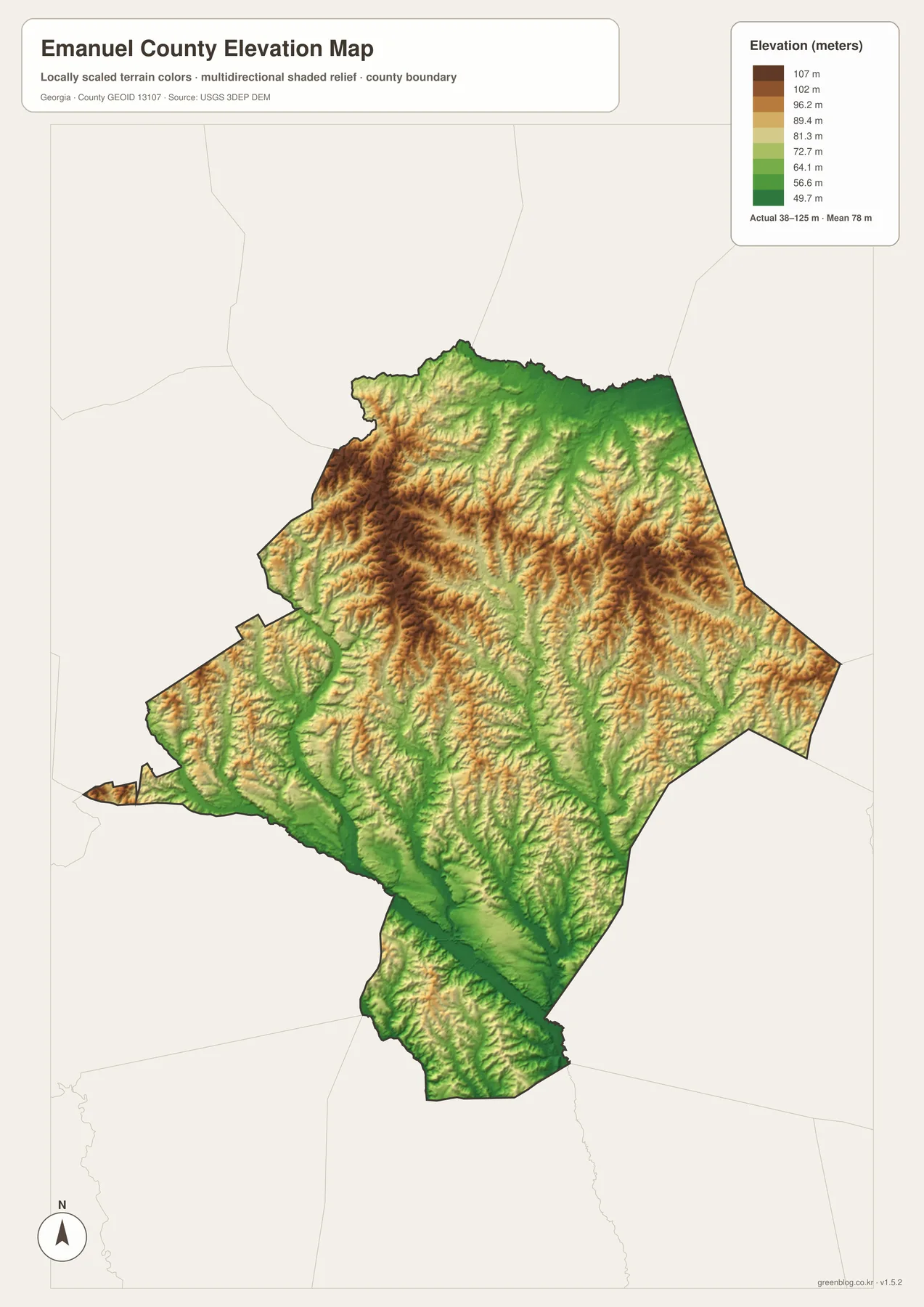
The elevation map reports an actual county range of about 38 to 125 meters, with a mean of 78 meters. Emanuel County is not mountainous, yet the shaded relief makes the internal differences surprisingly visible. Higher rolling ground appears as brown and tan ridges through much of the northwest and north-central interior, while greener low ground follows broader valleys. The most obvious low corridor runs from the southwest toward the south, matching the Little Ohoopee and Ohoopee river system seen on the water map. This correspondence between water and low terrain is one of the most useful reasons to compare the two maps.
The eastern and northeastern parts of the county also contain many small valleys. Narrow green channels branch between slightly higher ridges, creating a textured pattern rather than a uniformly flat surface. At county scale, those ridges and valleys explain why streams form such a dense network. They also provide context for the towns and roads shown on the other maps: a city marker may look isolated on the city map, but the elevation view reveals that the surrounding countryside has many small rises and drainage corridors. This is useful background when describing the landscape in a report or geography lesson.
The surface is generalized to show broad topographic differences, so it should not be treated as a survey-grade measurement for a construction site, drainage design, engineering work, or a specific property. The colors and shaded relief are intended to make county-wide patterns readable at a glance. If a project requires the exact elevation of a point, a more detailed DEM or field survey is appropriate. For general map reading, however, the 38–125 meter range and the visible low river corridors provide a clear summary of how elevation changes across Emanuel County.
Choosing the Right Emanuel County View
For a first look at Emanuel County, start with the general map. It combines the boundary, Swainsboro, smaller places, numbered roads, and surrounding reference towns in a single view. That makes it useful when the question is simply where the county is, which direction Twin City or Stillmore lies from Swainsboro, or how the western Adrian area relates to the rest of the county. Because the map stays at county scale, it is best for orientation rather than address finding or detailed driving instructions.
The city map is better when the focus is settlement distribution. By reducing the number of labels and ranking six major cities, it makes the contrast between Swainsboro and the smaller communities easier to explain. The water map is the better choice for rivers, creeks, ponds, and drainage context, while the elevation map is useful for showing how those waterways relate to lower valleys and higher rolling ground. A school project about towns might use the first two maps, whereas a project about physical geography could rely more heavily on the water and elevation views.
The four files are also useful together because each removes some information in order to emphasize something else. A simple city view cannot show the full density of streams, while the water map intentionally does not emphasize every settlement. The elevation map uses color and relief instead of road labels. Moving among the four versions prevents one crowded image from trying to answer every question at once. The downloadable A3 JPGs preserve that separation and provide a larger format than the webpage previews, which is helpful for printing or placing a map into a slide or document.
A County Established in 1812, Read Through Today’s Map
The supplied article and county reference material identify Emanuel County as having been established in 1812. Local descriptions often discuss forestry, agriculture, and Swainsboro’s role as a service center, but the maps on this page are not land-use or economic maps. They do not show how many acres are in timber, which fields are actively farmed, or where an industry is concentrated. Instead, they give the geographic framework needed before those topics can be studied: the county boundary, the towns, major roads, rivers, and the shape of the terrain. Census data and the New Georgia Encyclopedia links below can provide additional statistical and historical context.
Swainsboro remains the easiest anchor for reading that framework. From the county seat, the map opens east toward Twin City and Garfield, south toward Nunez, Stillmore, and Oak Park, west toward Adrian, and north toward Summertown and Canoochee. Because Emanuel County has an irregular outline and several long extensions, a reader who sees only a list of place names may not understand how far apart the communities are or which side of the county they occupy. The maps turn that list into a spatial relationship without requiring specialized GIS software.
The natural features provide a second framework. In the north, the Ogeechee River gives one regional water reference; in the west and south, the Little Ohoopee–Ohoopee system gives another. Smaller creeks connect the interior to those larger channels, and the elevation map shows many of the same corridors as low ground. Reading the county through both settlement and terrain therefore produces a more complete picture than focusing only on Swainsboro or only on the boundary line.
Frequently Asked Questions
Which cities are emphasized on the city map?
The ranked city view emphasizes Swainsboro, Twin City, Stillmore, Adrian, Oak Park, and Garfield. The more detailed county map also labels places such as Nunez, Summertown, and Canoochee, so the two views are useful for different levels of detail.
Which rivers are easiest to identify?
The Ogeechee River is labeled in the north, while the Little Ohoopee River and Ohoopee River form prominent references in the western, southwestern, and southern parts of the county. Several named creeks, ponds, and lakes are also shown.
What elevation range does the map show?
The elevation map states an actual range of approximately 38 to 125 meters and a mean of 78 meters. It is intended for county-scale comparison of higher ground and lower valleys, not for survey or engineering measurements at a specific site.
What is included in the downloadable ZIP?
The archive contains four high-resolution A3 JPG files covering the general county map, major-city distribution, waterways, and elevation. Each file emphasizes a different part of Emanuel County, so you can use one map or combine several in the same project.
Map File Information
Emanuel County A3 Map Files
- Included Files: General county map, major-city distribution map, waterways map, and elevation map
- File Type: Four high-resolution A3 JPG files in one ZIP archive
- Intended Use: Printing, education, presentations, and map-based projects
Related Maps
Sources and Reference Material
- U.S. Census Bureau TIGER/Line Shapefiles – county boundary and geographic reference data
- USGS National Hydrography – rivers and streams
- USGS 3D Elevation Program – elevation data
- U.S. Census Bureau QuickFacts: Emanuel County – current county statistics
- New Georgia Encyclopedia: Emanuel County – county history and regional background
Green Map creates custom-edited map images using open geographic data sources such as geoBoundaries, Natural Earth, OpenStreetMap, and government open data. These maps are edited visual materials, not raw data files, and are provided for education, documents, presentations, and graphic reference.