Elbert County sits in northeastern Georgia, where Elberton provides the clearest human reference point and the Savannah River provides the strongest natural one. The maps on this page let you move from a county-wide view of roads and places to a simpler city view, then to the stream network and finally to the county’s elevation. Elberton, Bowman, Dewy Rose, major route numbers, the Savannah River corridor, and terrain ranging from about 95 to 256 meters all appear in the supplied map set. Four high-resolution A3 JPG maps are also available together in one ZIP download for printing, classroom work, reports, or local reference.
Reading the maps together is especially useful because Elbert County is not defined by one city or one river alone. Elberton lies near the center of the road network, Bowman gives the northwest corner a second settlement reference, and the eastern side of the county is visually dominated by the broad, branching water along the Savannah River. The elevation map adds another layer: higher ridges are concentrated mainly in the west and northwest, while lower green terrain follows many valleys and becomes more extensive toward the east and southeast. That contrast explains why the water map contains so many small tributaries even though the ordinary county map can look relatively simple at first glance.
Table of Contents
Elberton as the road and place anchor
The county reference map is the best starting point when you need the overall shape of Elbert County and want roads, settlements, and streams in the same view. Elberton is shown as the largest built-up area and is easy to find near the middle of the county. Bowman appears to the northwest, while Dewy Rose is marked between Bowman and Elberton. Huguenot is also labeled as a historical place in the southeastern part of the map. These labels do not represent every community in the county, but they provide enough fixed points to understand where the principal roads and waterways sit in relation to one another.
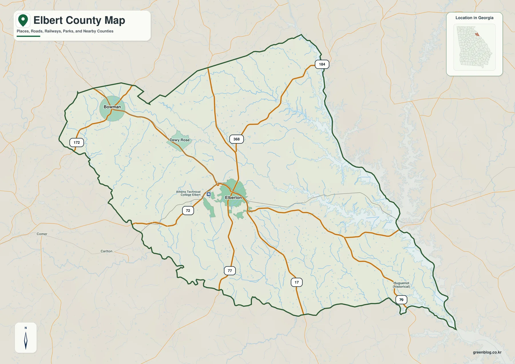
The route shields make Elberton’s central role even clearer. Route 72 crosses the county through Elberton in a generally west-to-east direction, while 77 runs through the same area on a more north-south course. Route 17 continues toward the southern side of the county, and 79 appears near the southeastern edge. In the northwest, 172 helps orient Bowman, while 184 is shown toward the northeast and 368 provides another north-central connection. The map is not designed to replace a turn-by-turn road map, but it makes the county’s main directional choices easy to see before you move to a more detailed navigation source.
This road pattern also gives the county map a practical advantage over a simple boundary outline. If you encounter a place name in a local-history article, a school assignment, or a county record, you can first locate Elberton or Bowman and then use the numbered routes to estimate the correct part of the county. The map also shows numerous blue stream lines crossing those roads, which is an early clue that the relief is more dissected than the broad county outline suggests. Once that relationship becomes important, the water and elevation maps provide a much clearer view.
Why the city map concentrates on Elberton and Bowman
The city-distribution map strips away much of the detail and emphasizes two ranked cities: Elberton as number 1 and Bowman as number 2. That sparse presentation is useful rather than incomplete because it immediately shows how strongly Elberton dominates the county’s urban pattern. Bowman occupies a very different position near the northwest corner, so the two markers create a simple frame for the county. Smaller settlement labels that appear on the general map, including Dewy Rose, are not part of the ranked city index and should be found on the county reference map instead.
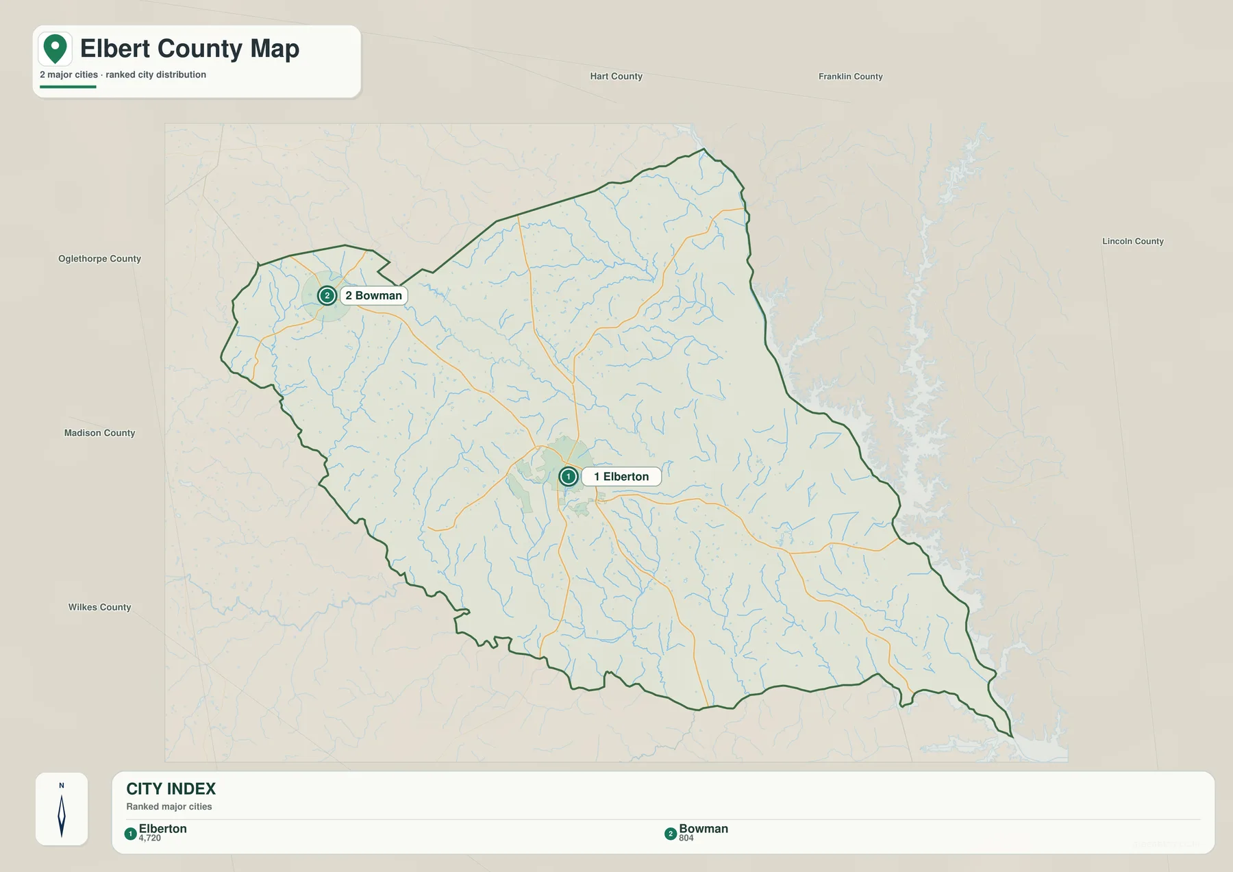
Names around the edge of the city map add regional context. Hart County, Franklin County, Madison County, Oglethorpe County, Wilkes County, and Lincoln County appear within the surrounding map area. Those labels are best read as nearby geographic references rather than as a claim that every name shown shares a direct boundary with Elbert County. They help you keep track of direction: Bowman lies toward the northwestern side, Elberton sits farther southeast, and the broad Savannah River water corridor is to the east.
After using this simplified map, returning to the county reference map becomes easier. You can see how 72 and 172 relate to Bowman, how 72, 77, and 17 separate around Elberton, and why many county trips naturally use Elberton as the main orientation point. For a county with a small number of prominent incorporated places, a clean city map can be more informative than a crowded display filled with every minor locality.
Savannah River, Broad River, and the network of creeks
The terrain-and-water map changes the character of the county completely. Instead of roads and settlement labels, the eastern side is dominated by the Savannah River and a wide, branching water corridor. Inside the county, dozens of smaller blue lines follow valleys toward larger channels. South Beaverdam Creek is labeled in the western half, Coldwater Creek appears farther north and east, and Broad River and Falling Creek provide strong references in the southern part of the map. The large number of unnamed tributaries is just as important as the named streams because it shows how finely the landscape is cut by drainage valleys.
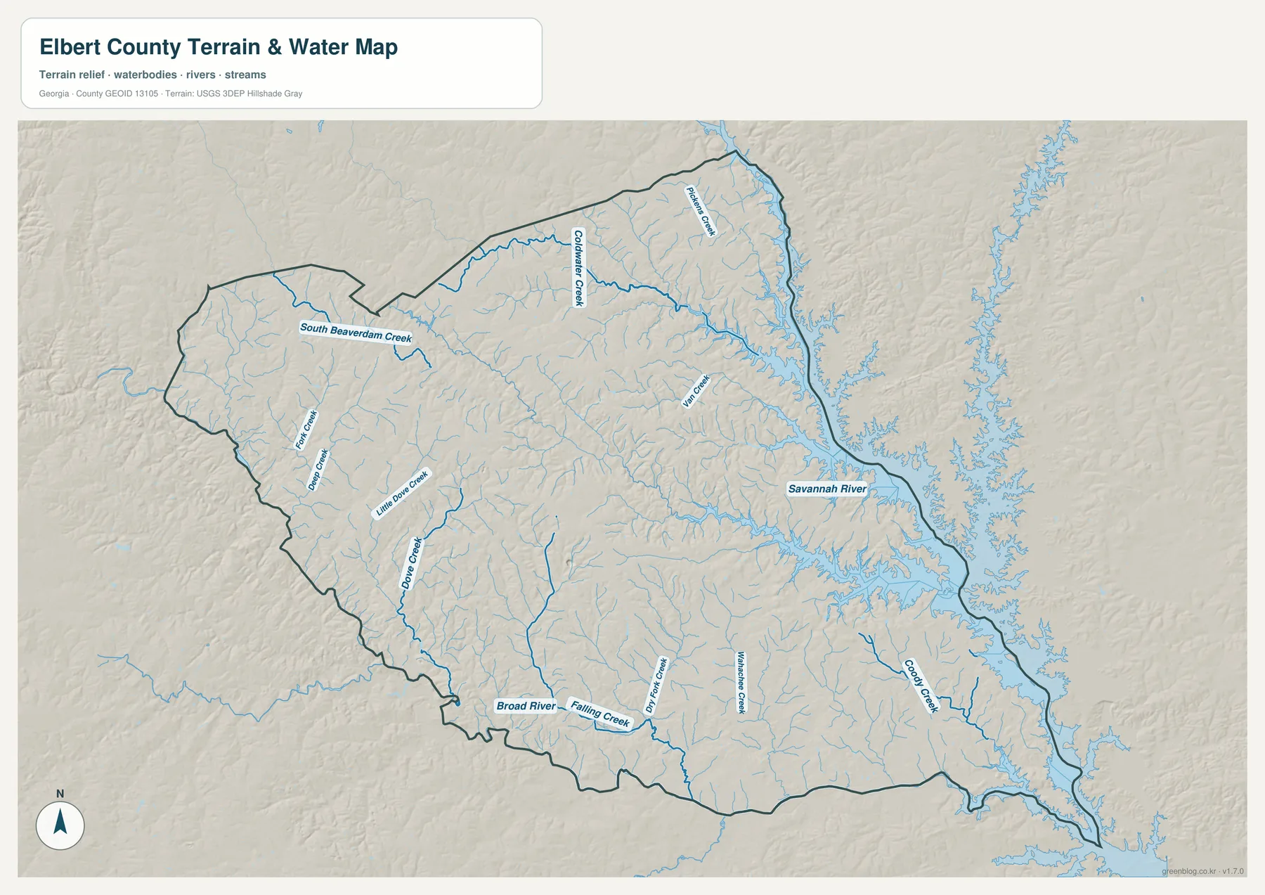
The Savannah River is the easiest feature to recognize because its water body is much wider than the interior creeks. Along the eastern side, the shoreline forms many long arms and narrow inlets, while the streams inside Elbert County remain thin until they reach larger channels. The relief shading beneath the blue lines helps explain that pattern. Creeks sit in low grooves between ridges, so a stream that looks winding on the map is often following the shape of a valley rather than crossing the landscape at random.
This map should be used as a geographic water reference, not as a flood-risk, parcel, legal-boundary, depth, or navigation product. It can show that a road or community lies near a named creek or near the Savannah River system, but it does not tell you whether a specific property floods or whether a channel is safe for boating. For those questions, use the appropriate official flood or navigation source. Here, the useful information is the county-wide relationship between water, valley shape, and the eastern river corridor.
From 95 to 256 meters: the county’s terrain contrast
The elevation map gives a measured range of roughly 95 to 256 meters and shows a mean elevation of about 170 meters. Darker browns represent the higher parts of the locally scaled surface, while greens indicate lower ground. The strongest concentration of high terrain appears in the west and northwest, with additional ridges extending through the northern half of the county. Lower green terrain becomes broader toward the east and southeast and follows many of the same valleys that stand out on the water map.
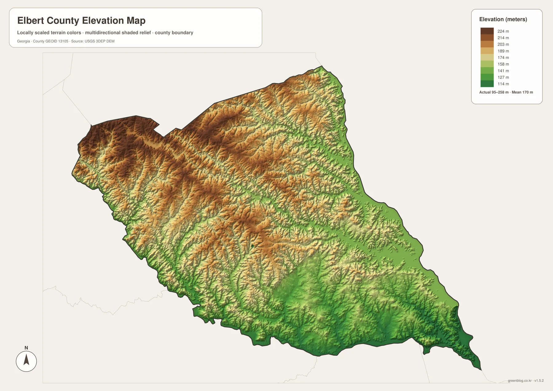
The most useful way to interpret this map is to compare it with the stream map rather than treating the colors as isolated bands. Green corridors frequently align with streams, and narrow valleys cut into the browner uplands. The county does not simply slope evenly from northwest to southeast; there are repeated ridges and valleys across the interior. This is why the water map contains so many tributaries and why some road lines on the general map cross a surprisingly varied landscape even when the county outline itself looks smooth.
The elevation surface is generalized for county-scale viewing. It is useful for understanding where the broad high and low areas are, but it is not a survey-grade or engineering-grade measurement for a particular parcel, building site, bridge, or road grade. If you need exact elevation at a point, use a more detailed official elevation product or a site survey. For ordinary geographic reading, however, the 95–256 meter range and the west-to-east contrast provide a clear explanation of Elbert County’s rolling terrain.
Granite history gives Elberton an extra layer of context
The supplied county material identifies Elbert County as a county established in 1790 and notes granite quarrying and monument production as important parts of the area’s identity. The maps here are not quarry or industrial-facility maps, so they should not be used to locate individual granite operations. What they do show is where Elberton sits within the county and why it works so well as the main reference point when reading local history. Elberton occupies a central position in the road network and is visually much more prominent than the other labeled settlements.
Bowman provides a useful counterpoint because it lies near the northwestern side of the county, away from Elberton’s concentration of roads. Dewy Rose sits between them on the county map, while the Savannah River corridor dominates the opposite, eastern side. The elevation map adds another distinction: the Bowman side of the county is generally closer to the higher western uplands, while lower terrain becomes more widespread toward the river. Combining those facts creates a more memorable picture of Elbert County than simply listing towns or repeating that Elberton is the county seat.
When a local-history source mentions Elberton, Bowman, granite production, the Savannah River, or rural communities in the county, the four maps can help place that information. Start with Elberton, identify the correct direction using the major routes, then switch to the water or elevation map if the story involves a river, creek, valley, or ridge. This method keeps historical context tied to real locations without pretending that the map contains industrial, property, or historical-boundary detail that it does not show.
Choosing the right Elbert County map for your task
Use the county reference map when your question begins with “where?” It is the only one of the four that brings major route numbers, several settlement labels, streams, and the county outline together. Use the city map when the main goal is to compare Elberton and Bowman without as much background detail. The water map is the stronger choice for the Savannah River, Broad River, and interior creeks, while the elevation map is best for explaining why the western side looks more rugged and why so many streams occupy narrow valleys.
For a classroom or report, a useful sequence is to begin with the county reference map, then add one specialized map that matches the subject. A transportation discussion may only need the county map and city map. A section about rivers or natural features will be clearer with the water map, and a terrain comparison is much easier with the elevation map. If the project discusses both water and relief, use those two together so readers can see how many low valleys correspond to blue stream lines.
The browser images are designed for quick reading on the page, while the downloadable archive contains the original high-resolution A3 JPG versions of all four maps. The ZIP includes the county reference map, city-distribution map, terrain-and-water map, and elevation map as separate files. That makes it possible to print one map, place different maps on separate report pages, or keep the entire set for future Elbert County reference without saving individual preview images from the webpage.
Frequently Asked Questions
Where is the Savannah River on the Elbert County maps?
On the terrain-and-water map, the Savannah River runs along the eastern side of the county and is much wider than the interior creeks. Its broad, branching water shape makes it easy to identify, and many smaller tributaries extend toward that river corridor from inside Elbert County.
Which map is best for comparing Elberton and Bowman?
The city-distribution map is the quickest option because it emphasizes Elberton and Bowman as the two ranked cities. If you also need Dewy Rose, route numbers, or the road relationship between the two cities, use the county reference map immediately afterward.
Can the elevation map be used for a property survey or engineering design?
No. The map is intended to show county-scale differences between higher ridges and lower valleys. Its 95–256 meter range is useful for geographic context, but a parcel, construction project, or engineering decision requires more detailed official data or a professional survey.
Map File Information
Elbert County high-resolution map files
- Included Files: County reference map, city-distribution map, terrain-and-water map, and elevation map
- File Type: Four high-resolution A3 JPG files in one ZIP archive
- Intended Use: Printing, education, presentations, and map-based projects
Related Maps
Sources and references
The article uses the supplied Elbert County maps and county package as its primary basis. The following references provide additional county background and authoritative national data for boundaries, hydrography, and elevation.
- U.S. Census Bureau QuickFacts – Elbert County, Georgia
- New Georgia Encyclopedia – Elbert County
- USGS National Hydrography
- USGS 3D Elevation Program
- U.S. Census Bureau TIGER/Line Shapefiles
Green Map creates custom-edited map images using open geographic data sources such as geoBoundaries, Natural Earth, OpenStreetMap, and government open data. These maps are edited visual materials, not raw data files, and are provided for education, documents, presentations, and graphic reference.