This Franklin County North Carolina Map page helps you locate Louisburg, Franklinton, Youngsville, Bunn, Centerville, the county road network, the Tar River, and Lake Royale. High-resolution JPG map files are available in a ZIP download below, while the three web previews let you compare general roads and places, city connections, and waterways before choosing the file you need.
Franklin County is easier to understand when Louisburg is used as the first reference point. The county map places Louisburg near the middle, with Franklinton and Youngsville to the southwest, Bunn to the south, and Centerville farther east. The water map then adds a different layer: the Tar River, Cedar Creek, Sandy Creek, Red Bud Creek, Cypress Creek, Crooked Creek, Little River, Lake Royale, and several named ponds. Together, these views show why a single road map cannot answer every question about the county.
Table of Contents
Louisburg is the clearest starting point for the road map
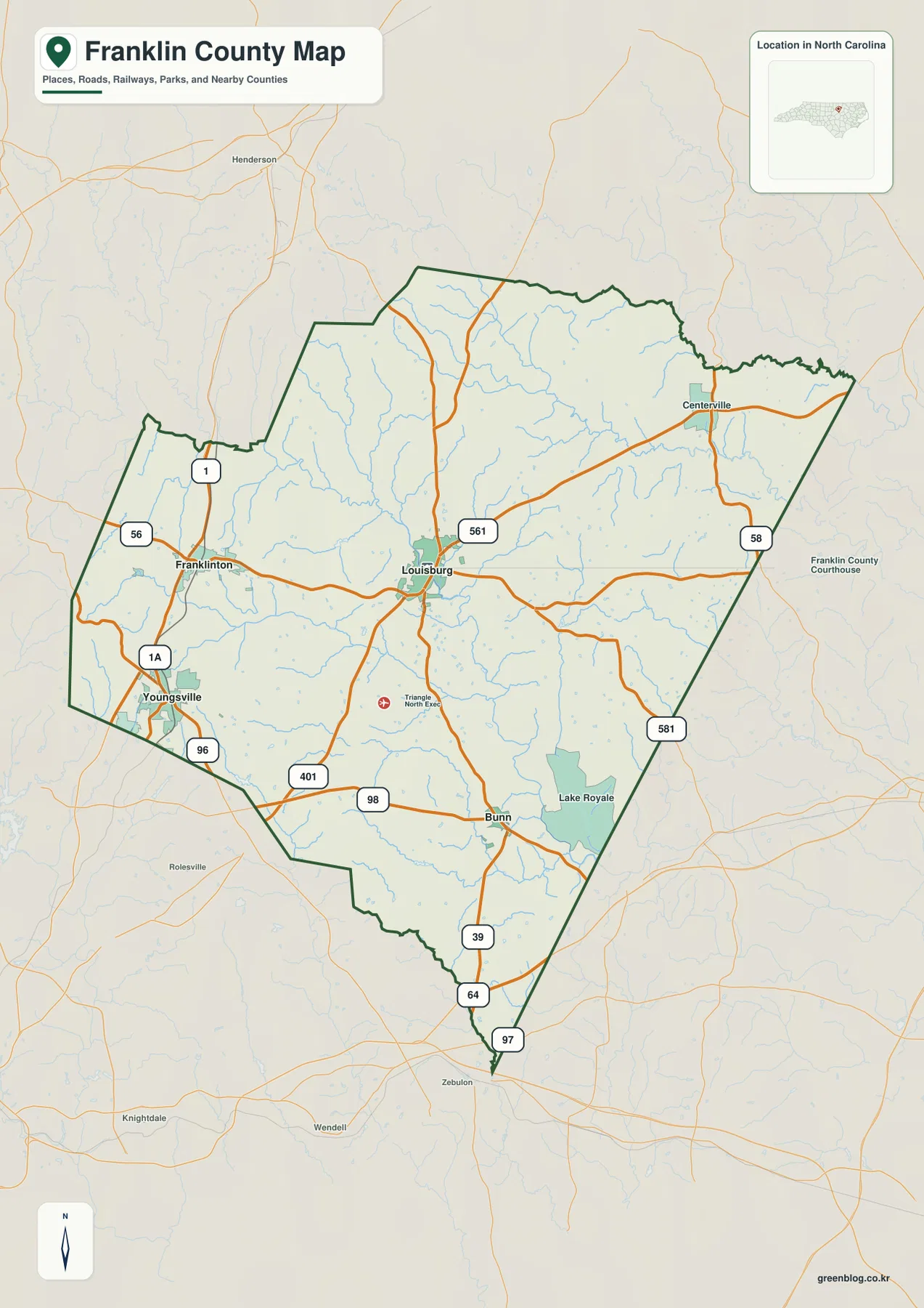
On the general county map, Louisburg stands out because several numbered routes meet or pass close to it. Route 401 runs through the central part of the county, while 561 crosses the Louisburg area from west to east. South of town, the road network connects toward 98 and continues toward Bunn. To the east, 581 provides another visible reference for following the county toward its southeastern side.
Franklinton sits west-southwest of Louisburg near routes 1 and 56, and Youngsville appears farther south near 1A and 96. These two places are close enough to appear in the same southwest portion of the county, but the map keeps their positions distinct. Using Louisburg as the anchor makes the difference easy to see: Franklinton is more directly west of the county center, while Youngsville lies closer to the southern edge.
Bunn is another useful locator because it sits south of Louisburg near routes 98 and 39, with 64 and 97 visible closer to the county’s pointed southern end. Lake Royale lies east of Bunn and is large enough to serve as a visual landmark even before switching to the water map. Centerville, on the eastern side near the 561 and 58 corridor, provides a separate reference for the county’s less urban eastern half.
The outside labels also help with orientation. Warren and Nash counties are shown along the northern and eastern sides, while Vance, Granville, Wake, Johnston, and Halifax appear around other parts of the perimeter. Those labels are useful when Franklin County is being compared with a neighboring county map because they show which edge of the county a road or settlement is approaching.
The city connection map makes the southwest-to-center pattern easier to compare
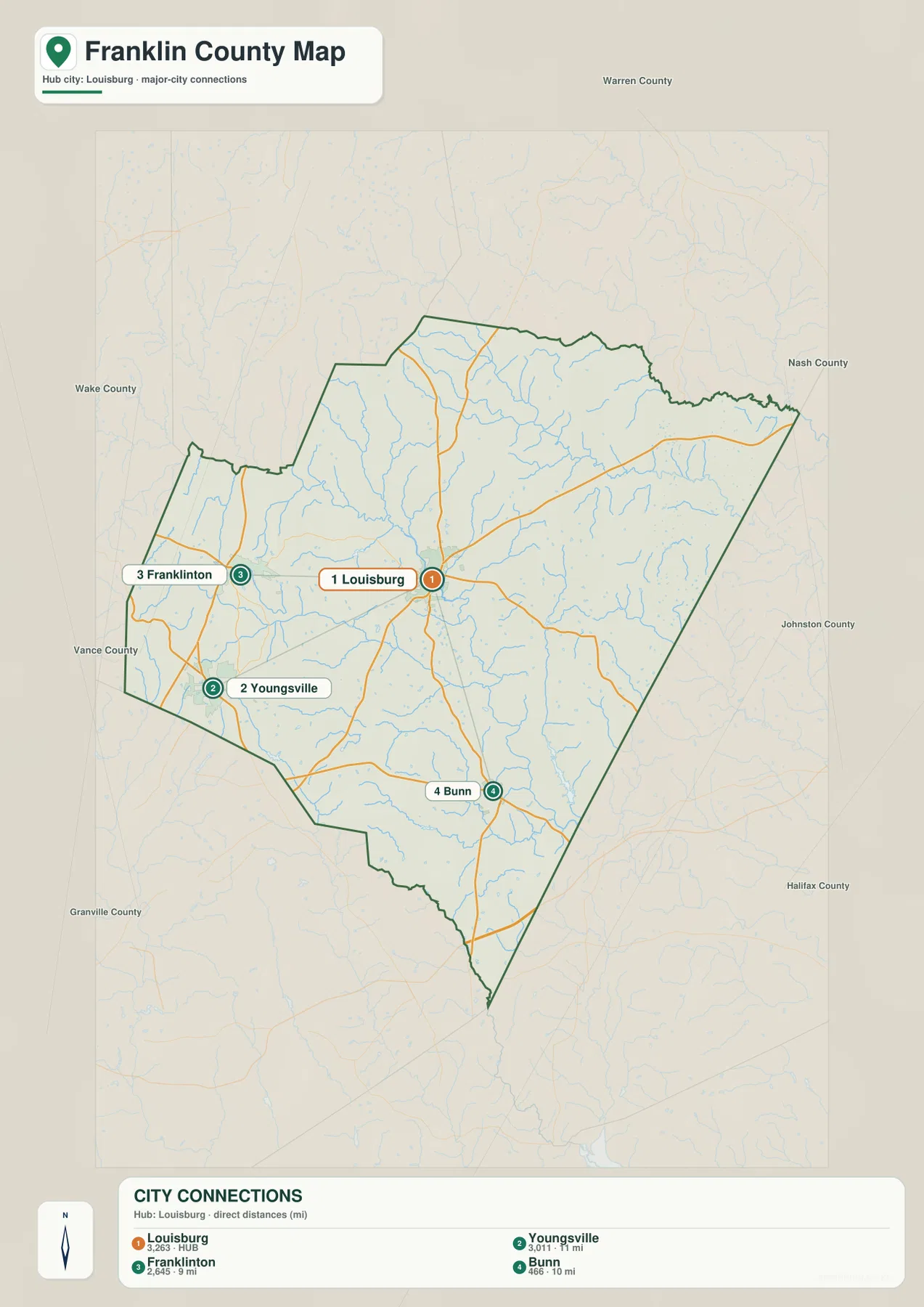
The city connection map strips away much of the secondary labeling and treats Louisburg as the hub. Franklinton, Youngsville, and Bunn are numbered as the other highlighted places. The map lists direct distances from Louisburg of about 9 miles to Franklinton, 10 miles to Bunn, and 11 miles to Youngsville. These are straight-line reference distances rather than driving distances, so they are most useful for comparing separation on the county map, not for estimating travel time.
That simplified layout is especially helpful when the question is not which road to follow but how the main settlements relate to one another. Franklinton and Youngsville occupy the southwest, while Bunn lies south of the county center. Louisburg remains the shared point from which the other locations can be compared. Because the routes remain visible in the background, you can still connect those city positions back to the more detailed county map when needed.
The city view also leaves plenty of space around the county outline, so the surrounding county names are easier to notice. This helps when placing Franklin County within the larger North Carolina setting. Rather than treating the county as an isolated shape, the map shows that its southwest settlements sit closer to the Wake and Granville sides, while the eastern side approaches Nash, Johnston, and Halifax County labels.
Tar River, creeks, ponds, and Lake Royale add the physical geography
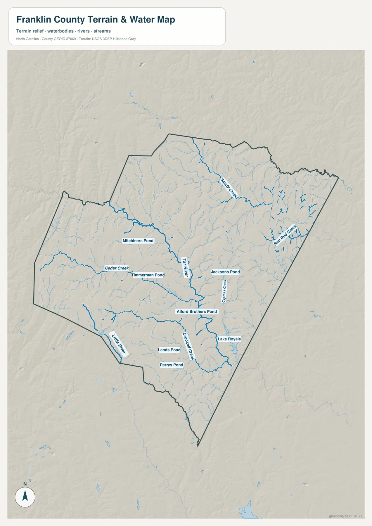
The terrain and water map changes the emphasis completely. The Tar River is the main named river through the central portion of Franklin County, and smaller streams branch toward it from several directions. Instead of seeing the county as a set of road corridors, this map shows a dense network of valleys and drainage lines. The difference matters because a town that looks close to another town on the road map may still be separated by one or more creeks.
Cedar Creek approaches from the west and is labeled near Timmerman Pond. Farther north, Sandy Creek crosses the upper part of the county, while Red Bud Creek forms a noticeable network of branches in the east. Cypress Creek is labeled east of the Tar River, and Crooked Creek appears farther south near the Lake Royale area. Little River is visible near the southwestern edge, providing another water reference away from the Tar River itself.
Lake Royale is the most visually prominent named lake on the supplied water map. It lies in the southeastern part of the county and connects naturally with the surrounding stream network when you follow the blue lines outward. Several smaller named water bodies are also shown, including Mitchiners Pond, Timmerman Pond, Jacksons Pond, Alford Brothers Pond, Lands Pond, and Perrys Pond. Their smaller size makes them easy to miss on the general road map, which is exactly why the dedicated water view is useful.
The shaded terrain background gives a general sense of rolling ground and shallow stream valleys, but this package does not contain a separate elevation map or a table of elevation values. For that reason, the relief should be used as a visual aid rather than as a source for exact heights. The reliable map information here is the visible relationship among the river, creeks, ponds, roads, and county boundary.
Choose the map by the question you are trying to answer
If you need one map for basic orientation, start with the general county map. It combines the county outline, settlement names, roads, and nearby county labels in one view. It is the easiest option for locating Louisburg, tracing the direction toward Franklinton or Youngsville, or checking where Bunn and Centerville sit relative to the county center.
The city connection map is better when you want a cleaner comparison among the main highlighted settlements. Because Louisburg, Franklinton, Youngsville, and Bunn are emphasized with numbered markers and direct-distance labels, the map makes their spacing obvious without requiring the reader to follow every route. That can be helpful in a presentation, a simple county overview, or any situation where settlement relationships matter more than the full road network.
The water map is the right choice when the Tar River or smaller waterways are central to the explanation. It lets you follow Cedar Creek and Sandy Creek toward the larger river, find Red Bud Creek and Cypress Creek on the eastern side, and see how Crooked Creek and Lake Royale fit into the southern half. It also includes small named ponds that are not the focus of the other two maps.
A practical way to use the set is to move from the general map to the more specialized view only when a question requires it. For example, find Bunn on the county map first, use the city map if you want to compare its distance from Louisburg, and then open the water map if you need to identify Lake Royale or nearby streams. That sequence keeps the page easy to read without forcing every type of information into one image.
A few Franklin County details worth checking before you print
Before downloading, zoom in on the web previews and decide which labels you need to remain legible in the final use. The general map contains more road numbers and place names, so it works well when those labels are important. The city map has fewer competing labels and therefore gives Louisburg, Franklinton, Youngsville, and Bunn more visual emphasis. The water map replaces much of the road detail with stream and pond names.
For a countywide orientation handout, Louisburg is a sensible first label because it sits near the center of the map. Franklinton and Youngsville then define the southwest side, Bunn helps identify the southern interior, Centerville gives the eastern side a clear place reference, and Lake Royale provides a strong water landmark in the southeast. This is more informative than describing Franklin County only as a boundary shape.
When waterways matter, begin with the Tar River and then look outward to the named tributaries. Cedar Creek, Sandy Creek, Red Bud Creek, Cypress Creek, and Crooked Creek are spread across different parts of the county, so they help distinguish the west, north, east, and south without relying only on road numbers. Small ponds such as Jacksons Pond or Timmerman Pond can provide an additional local reference when a more detailed map explanation is needed.
Frequently Asked Questions
Which map is best for comparing Louisburg, Franklinton, Youngsville, and Bunn?
Use the city connection map when the main goal is to compare those four places. It treats Louisburg as the hub and shows direct-distance references of about 9 miles to Franklinton, 10 miles to Bunn, and 11 miles to Youngsville. Use the general county map instead when you also need road numbers and the full county boundary.
Where can I see the Tar River and Lake Royale together?
The terrain and water map shows both. The Tar River is the main central river, while Lake Royale is a prominent water body in the southeastern part of the county. The same map also labels Cedar Creek, Sandy Creek, Red Bud Creek, Cypress Creek, Crooked Creek, Little River, and several named ponds.
What is included in the downloadable Franklin County ZIP?
The ZIP contains high-resolution JPG files for the general county map, city connection map, and terrain/water map. These are the larger map files corresponding to the three web previews used in the article.
Sources and reference data
Map File Information
The download ZIP contains high-resolution JPG versions of the Franklin County general map, city connection map, and terrain/water map. The images on this page are web previews; use the JPG files in the ZIP when you need the larger source maps for printing or offline use.
- Included Files: Use only the versions confirmed in the article and supplied images
- File Type: Use the confirmed download contents
- Intended Use: Printing, education, presentations, and map-based projects
Related Maps
Green Map creates custom-edited map images using open geographic data sources such as geoBoundaries, Natural Earth, OpenStreetMap, and government open data.
These maps are edited visual materials, not raw data files, and are provided for education, documents, presentations, and graphic reference.