Gaston County sits immediately west of Mecklenburg County in North Carolina’s Piedmont, but its geography changes noticeably from one side to the other. Gastonia provides the easiest urban reference in the interior, Belmont and Mount Holly sit close to the Catawba River on the east, and the Crowders Mountain area gives the southwest a much rougher landscape. This page brings those differences together with a county reference map, a simplified city map, and a water-and-terrain map. After viewing the WebP maps in the article, readers can download the matching high-resolution A3 JPG files in one ZIP.
The county is bordered by Cleveland County to the west, Lincoln County to the north, and Mecklenburg County to the east, while part of its southern edge meets South Carolina. That setting helps explain why a single description of Gaston County can be misleading. The eastern side is strongly influenced by the Catawba River and communities facing the Charlotte side of the river, the center is organized around Gastonia and nearby towns, and the southwest rises into the Crowders Mountain landscape. Reading the maps together makes those local contrasts much easier to follow than treating the county as one continuous urban area.
Table of Contents
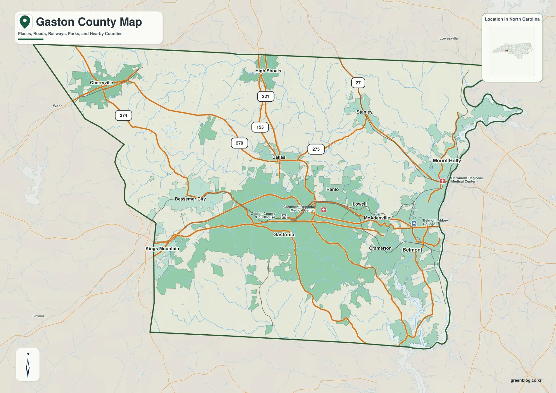
From Gastonia to Belmont, the county map shows two different urban settings
Gastonia appears near the south-central part of the county and serves as the clearest place to begin. Moving east from Gastonia, the map shows Ranlo, Lowell, McAdenville, and Cramerton before reaching Belmont near the Catawba River. Mount Holly lies farther northeast along the river-facing edge. Dallas is north of Gastonia, Bessemer City is to the west, and Cherryville sits much farther northwest. Those positions show that the county’s named communities are distributed across several directions rather than packed into one compact center.
The eastern cities also sit in a different geographic setting from Gastonia. Belmont and Mount Holly are close to the Catawba River, which separates much of Gaston County’s east side from Mecklenburg County. The reference map also marks places such as Belmont Abbey College and CaroMont Regional Medical Center, providing useful local landmarks without turning the page into a street-navigation map. For county-scale orientation, the strongest comparison is between inland Gastonia and the river-side communities to the east.
The numbered roads make Dallas, Stanley, Cherryville, and High Shoals easier to place
The reference map becomes more useful when the numbered roads are treated as orientation lines rather than turn-by-turn directions. Route 321 is especially prominent through the High Shoals and Dallas area toward Gastonia. Route 27 appears near Stanley in the northeast, while 274 is marked around Cherryville in the northwest. Routes 275 and 279 are visible around Dallas and the eastern side of the county. Together, these road labels help a reader separate the northern communities from the denser belt of places around Gastonia and the eastern river cities.
That northern half has a different visual rhythm from the Gastonia-to-Belmont corridor. Cherryville stands apart in the northwest, High Shoals is near the north-central edge, and Stanley lies toward the northeast. Dallas is the key intermediate point because it sits immediately north of Gastonia and near several of the marked roads. The map does not show every local street, so it should not be used as a substitute for navigation. Its strength is showing which towns share the same general side of the county and which routes provide the clearest county-wide reference.
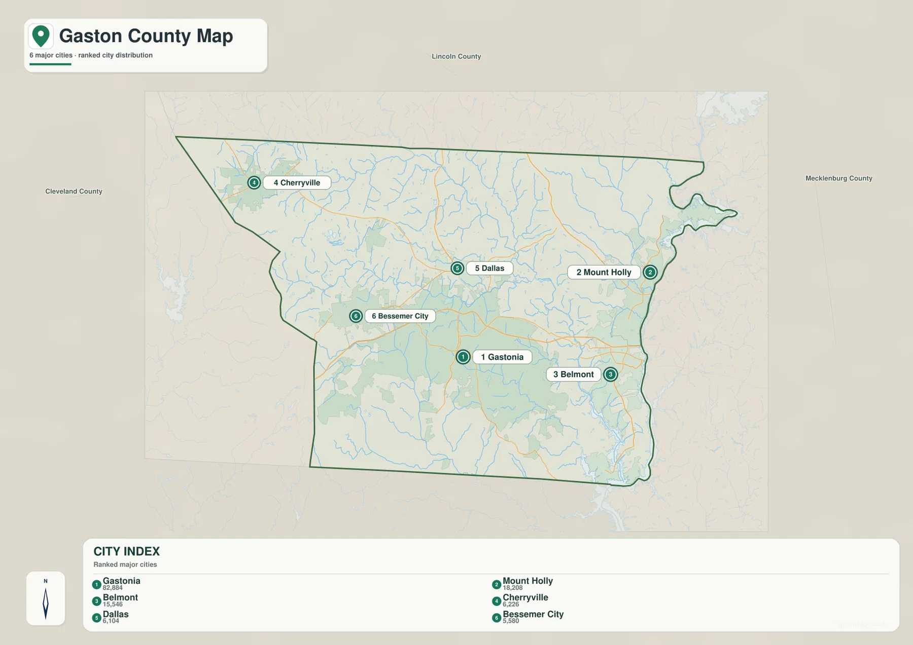
A six-city index strips the map down to the main urban reference points
The city map highlights Gastonia, Mount Holly, Belmont, Cherryville, Dallas, and Bessemer City. Gastonia remains near the south-central area, Mount Holly and Belmont are on the east, Dallas is north of Gastonia, Bessemer City is on the west, and Cherryville occupies the northwest. By removing most of the secondary labels from the general map, this version makes the spread of the selected cities easier to compare. It is particularly useful when the question is where the major places are located rather than which road, creek, park, or facility lies beside them.
The graphic also includes a ranked City Index with numeric values. Those values belong to the map’s own city-comparison layer and should not be treated as a replacement for current official population statistics. For population research, Census tables are the better source. Here, the index is most useful for identifying the six emphasized places and seeing how the eastern pair of Mount Holly and Belmont differs from inland Gastonia, western Bessemer City, northern Dallas, and northwestern Cherryville.
Waterways become the main guide east and south of Gastonia
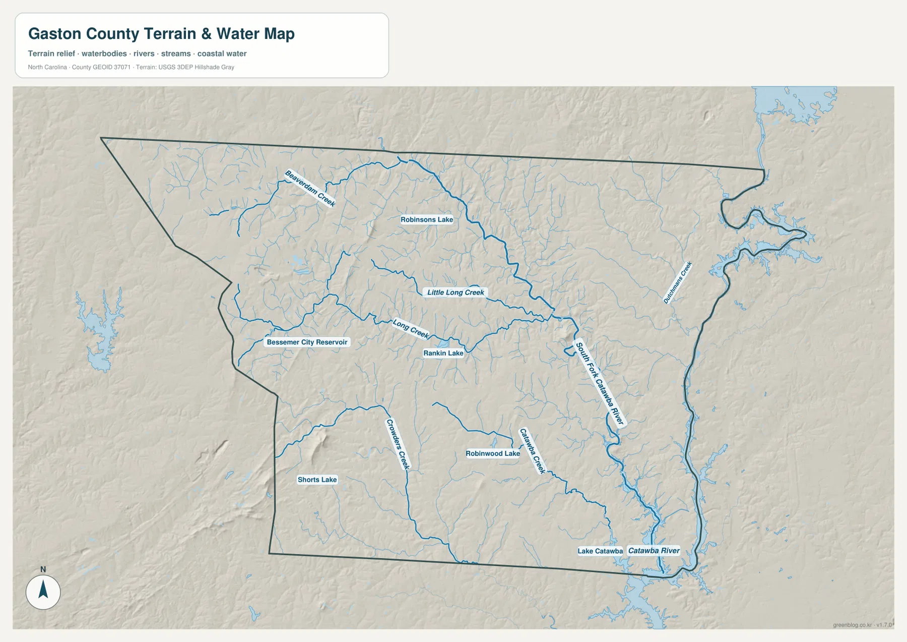
The water-and-terrain map changes the way the county is read. The Catawba River follows much of the eastern side, while the South Fork Catawba River curves through the eastern interior before reaching the larger river system farther south. Dutchmans Creek is labeled in the northeast. Long Creek and Little Long Creek cross the central and western portions, while Crowders Creek and Catawba Creek provide strong references in the southern half. These named waterways make it easier to describe places that do not sit directly beside one of the six highlighted cities.
Several smaller water bodies add even more local reference points. Rankin Lake appears northwest of Gastonia, Bessemer City Reservoir is shown in the west, Robinsons Lake is farther north, and Robinwood Lake and Shorts Lake appear in the southern part of the county. Lake Catawba is labeled near the southeast. Their value on this map is positional: they help narrow down where a place lies within the county. The map does not provide current water levels, water quality, flood-zone boundaries, or legal shoreline information.
Crowders Mountain gives the southwest a much stronger terrain signature
The shaded relief becomes noticeably stronger in the southwest than across the flatter-looking central and eastern areas. That part of the county includes Crowders Mountain State Park, where North Carolina State Parks identifies Crowders Mountain and Kings Pinnacle as the park’s two prominent peaks. The supplied map is not a separate elevation map and does not provide survey-grade heights, but the background relief is enough to show why the southwest should not be described in the same way as the Belmont and Mount Holly side of the county.
Crowders Creek also runs through the southwestern portion, giving the water map a useful connection between terrain and drainage. A reader can move from the ridged background near Crowders Mountain toward lower river-oriented areas in the east and see how much the county changes over a relatively short distance. Anyone planning a hike should still use the official Crowders Mountain State Park trail map and current park information, because this county map is designed for regional orientation rather than trail navigation or terrain measurement.
Dallas and Gastonia preserve two chapters of the county-seat story
NCpedia records that Gaston County was formed from Lincoln County in 1846. Dallas was the original county seat, and Gastonia became the county seat in 1911. That history gives extra meaning to the short north-south relationship between the two places on the modern map. Dallas is not simply another community north of Gastonia; it was the county’s first administrative center. Gastonia’s present role helps explain why the current reference map uses it as the clearest starting point for surrounding roads, facilities, and nearby communities.
The two places also provide a convenient way to read the county from past to present without adding unnecessary detail to the map itself. Dallas remains easy to locate because it sits near the 321 corridor and several other marked roads, while Gastonia anchors the larger concentration of urban features to the south. This combination of history and geography is more informative than treating every town name as equivalent, and it is specific to the way Gaston County developed.
Use the road, city, or water map according to the question you are trying to answer
The general county map is the best starting point when you need several layers at once: municipal names, major numbered roads, selected facilities, waterways, and the county boundary. The city map is cleaner when the task is to compare Gastonia, Mount Holly, Belmont, Cherryville, Dallas, and Bessemer City without the rest of the labels. The water-and-terrain map is the better choice for following the Catawba River, South Fork Catawba River, Long Creek, Crowders Creek, and the smaller named lakes and reservoirs. Each version removes some information so that another type of relationship becomes easier to see.
For large-screen viewing or printing, the downloadable JPG files provide more resolution than the in-article WebP previews. The ZIP contains the high-resolution A3 JPG counterparts to the county reference map, city map, and water-and-terrain map shown here. They are appropriate as general geographic reference images, but they are not substitutes for parcel surveys, flood-hazard products, legal boundary records, engineering elevation data, or real-time navigation. Those uses require the latest specialized information from the responsible agency.
Frequently Asked Questions
What makes the eastern side of Gaston County easy to recognize on the map?
The Catawba River is the strongest geographic reference on the east side. Mount Holly and Belmont sit close to the river, while Gastonia is farther inland. That contrast makes it easier to distinguish the eastern river-facing communities from the county’s interior.
Which places are emphasized on the simplified city map?
The city map emphasizes Gastonia, Mount Holly, Belmont, Cherryville, Dallas, and Bessemer City. The broader county map adds other places such as Stanley, High Shoals, Lowell, McAdenville, Ranlo, and Cramerton, so use the reference map when you need more community names.
Can the water-and-terrain map be used as a flood or property-boundary map?
No. It is a regional reference map for locating rivers, creeks, lakes, and broad terrain relief. It does not show flood-zone determinations, current river conditions, parcel lines, legal boundaries, or survey measurements. Those questions require current official data from the appropriate federal, state, or local agency.
Sources and Reference Data
- NCpedia – Gaston County
- North Carolina State Parks – Crowders Mountain State Park
- U.S. Census Bureau TIGER/Line Shapefiles
- USGS National Hydrography
Map File Information
The ZIP contains the high-resolution A3 JPG versions of the Gaston County reference map, city map, and water-and-terrain map displayed on this page.
- Included Files: County reference map JPG, city map JPG, and water-and-terrain map JPG
- File Type: ZIP containing three high-resolution A3 JPG files
- Intended Use: Printing, classroom reference, presentations, and regional map projects
Related Maps
Green Map creates custom-edited map images using open geographic data sources such as geoBoundaries, Natural Earth, OpenStreetMap, and government open data.
These maps are edited visual materials, not raw data files, and are provided for education, documents, presentations, and graphic reference.