White County sits in southeastern Illinois, with Carmi serving as the clearest central reference point and communities such as Grayville, Crossville, Enfield, Norris City, and Mill Shoals spread across the county. The maps on this page show the county boundary and principal roads, a simplified distribution of major communities, the Little Wabash and Fox River water network, and countywide relief ranging from about 102 to 175 meters. After reviewing the web maps, you can download a ZIP containing the same four maps as high-resolution JPG files for printing or larger reference use.
Carmi is the easiest place to begin because several important roads meet around it. Route 1 runs northeast toward Crossville and Grayville, Route 14 extends west toward Enfield, and the western side of the county is organized around the north-south 45 corridor. Interstate 64 crosses the northern part of White County, providing an east-west reference line above Carmi. The county’s official website also identifies I-64 as a major east-west travel route, so the road pattern visible on the map matches an important part of the county’s present-day orientation.
The natural geography becomes much more obvious when the road map is compared with the water and elevation maps. Little Wabash River crosses the northern and eastern part of the county, while Little Fox River and Fox River stand out farther east. Near the eastern edge, Old Channel Wabash River and Old River mark additional low-water corridors. The elevation surface shows a broad green lowland across much of the east and southeast, contrasted with higher ridges in the west and northeast. White County therefore has a more varied landscape than a simple road map alone suggests.
Table of Contents
Carmi as the road reference for White County
The general county map places Carmi slightly east of the county’s center and makes it the strongest visual hub. From Carmi, the map leads northeast through Crossville toward Grayville, west toward Enfield, southwest toward Norris City, and southeast toward Maunie and New Haven. Phillipstown appears east of Crossville, while Mill Shoals, Burnt Prairie, and Springerton help define the northwestern side. Because these places are distributed in several directions, Carmi is a useful anchor for describing the county without reducing everything to one edge or one highway.
The main roads reinforce that pattern. Interstate 64 runs east-west across the northern tier and approaches Grayville near the northeastern corner. Route 1 links Carmi with Crossville and the Grayville side of the county. Route 14 heads west from Carmi toward Enfield, while the 45 corridor runs north-south through the western side near Mill Shoals, Springerton, Enfield, and Norris City. Smaller numbered roads are more prominent in the south, where New Haven and the irregular southern boundary make the map less rectangular than many inland county maps.
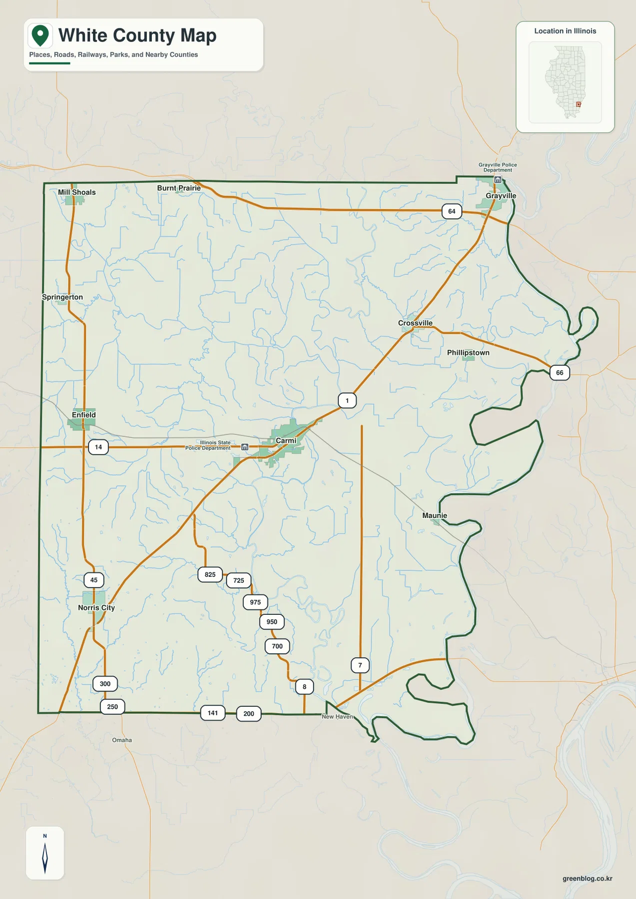
The county boundary is especially distinctive on the east and southeast. Instead of following a simple straight line, it bends around a series of river-related curves and narrow extensions. The road map does not explain every channel in detail, but it clearly hints that water has shaped this side of the county. The water map later makes that relationship more obvious by identifying the Little Wabash, Fox River system, Old Channel Wabash River, and Old River.
For practical orientation, the general map is the best starting point when you need roads and communities at the same time. It can show that Grayville sits at the northeastern edge, Norris City lies in the southwest, and New Haven is close to the southern boundary, while Carmi remains inside the county rather than on an outer edge. It is not a turn-by-turn navigation product, so current driving conditions and precise routes should still be checked with a modern road or navigation service.
A dispersed settlement pattern from Grayville to Norris City
The city-distribution map removes much of the road detail and highlights six major communities: Carmi, Norris City, Grayville, Crossville, Enfield, and Mill Shoals. Carmi occupies the interior reference position, Norris City is southwest, Grayville is at the northeastern edge, Crossville sits between Carmi and Grayville, Enfield is west, and Mill Shoals is near the northwestern corner. The result is a widely dispersed pattern rather than one continuous urban strip.
The city index printed on the map ranks Carmi first, followed by Norris City, Grayville, Crossville, Enfield, and Mill Shoals. Those printed values belong to this map package and are best treated as a map index rather than a substitute for the latest official population estimates. The more useful information here is the relative position of the communities. Grayville and Mill Shoals occupy opposite ends of the northern side, while Norris City and Carmi create a southwest-to-center relationship and Crossville extends the settlement pattern toward the east.
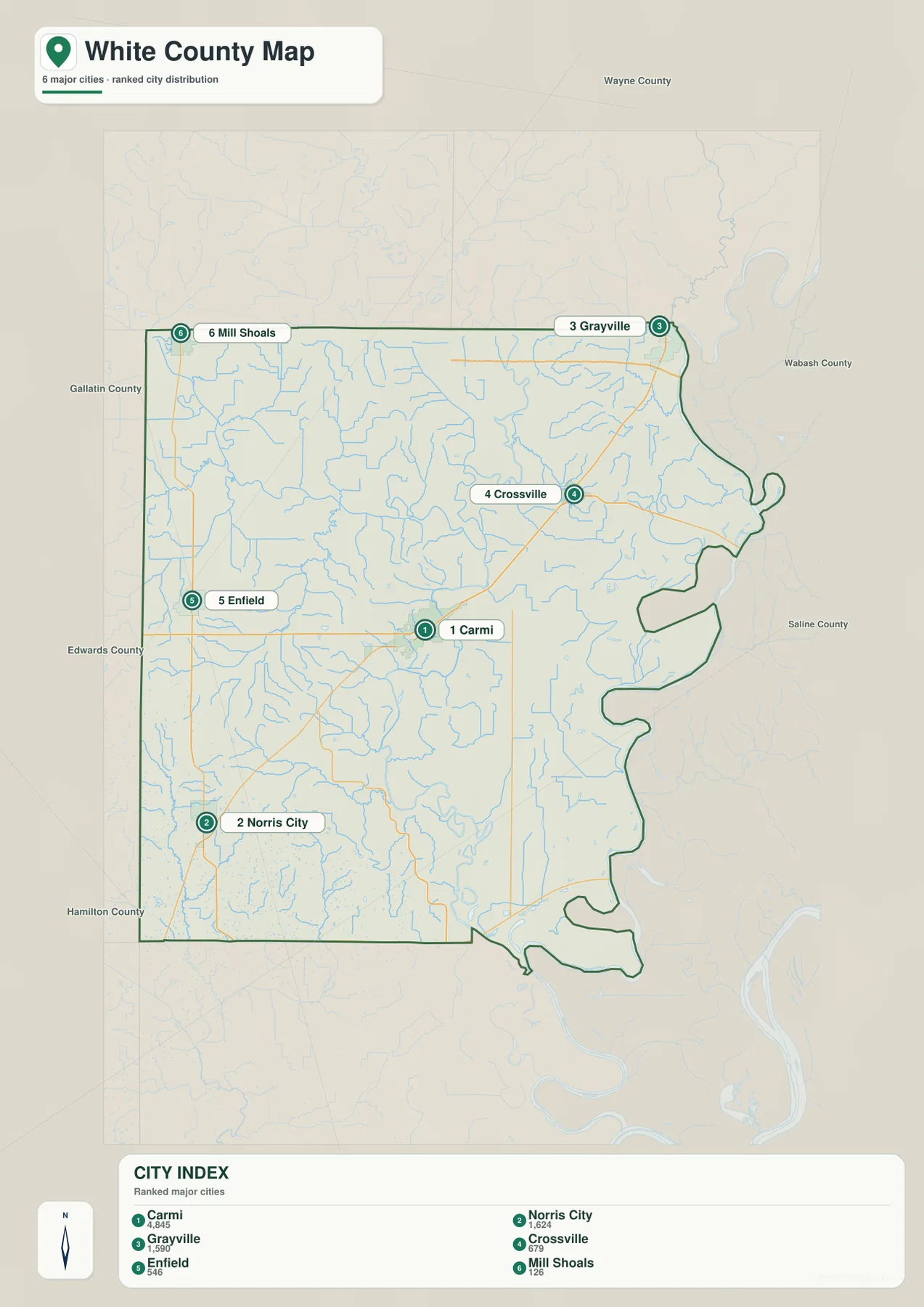
Neighboring county labels help explain why the outer communities feel so separated. Wayne County is shown to the north, Gallatin and Edwards counties to the west, Hamilton County toward the southwest, Wabash County to the east, and Saline County toward the southeast. Mill Shoals and Grayville sit close to county edges, while Carmi lies farther inside. This makes the city map useful for understanding White County as a collection of small centers spread across a broad rural area rather than as a single concentrated city zone.
This map does not draw distance connectors between the communities. It should therefore be used to compare direction and distribution, not to estimate driving mileage or travel time. For example, it is easy to see that Grayville is northeast of Carmi and Norris City is southwest, but the actual road route between those places depends on the highway network. Pair the city map with the general road map when a project needs both settlement pattern and transportation context.
Little Wabash, Fox River, and the old channels along the east
The terrain-and-water map shifts attention away from roads and toward drainage. Little Wabash River is one of the strongest named features, running through the northern and eastern part of White County. Little Fox River and Fox River appear farther east, and several smaller tributaries feed into these larger channels. Along the eastern edge, Old Channel Wabash River and Old River are labeled separately, showing that the lowland water network contains more than one present-day river line.
The western and central parts of the county also contain a dense network of smaller streams. Skillet Fork is labeled on the west side, while City Reservoir appears southwest of Carmi. Browns Pond lies closer to the center, and Flat Pond and Clear Pond are shown farther east. Near the south, The Bayou and Goose Pond Swamp add wetland and backwater features to the map. These names give the county a much richer water geography than the general road map initially reveals.
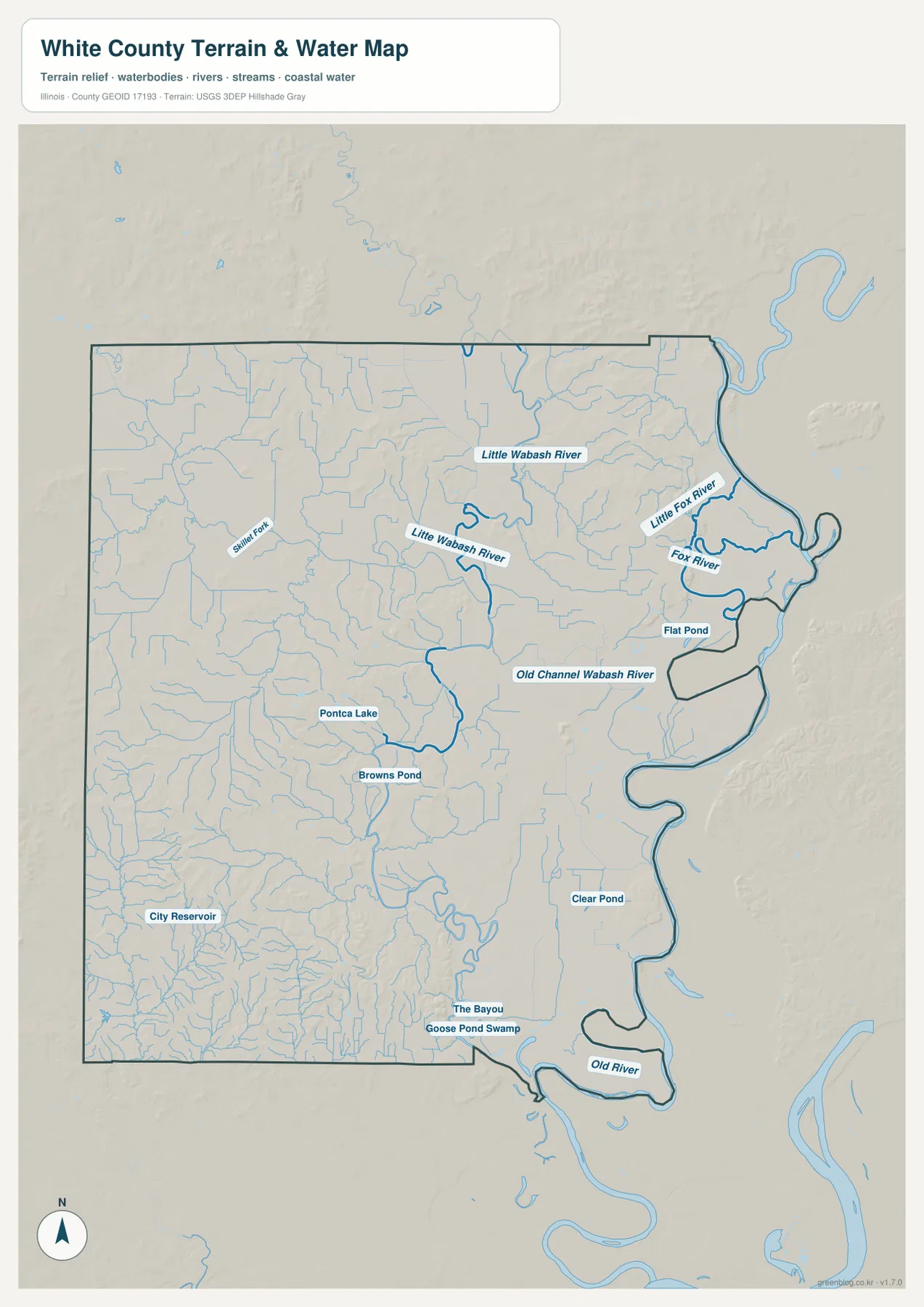
The official White County website describes early settlement on fertile ground along the Little Wabash River, which helps explain why the river is a useful geographic reference even in a modern map article. On the supplied map, the Little Wabash does not stand alone; it is part of a broader system of forks, ponds, old channels, and low-lying corridors. That combination is especially noticeable in the eastern half of the county, where the boundary and waterways repeatedly curve around one another.
This is a reference map for water-feature location, not a flood-hazard, depth, navigation, or property-boundary product. A label such as Old Channel Wabash River does not indicate that every segment carries the same amount of water today, and the map does not show seasonal flow conditions. Its strength is geographic orientation: it shows where named rivers, smaller streams, ponds, wetlands, and old channels sit in relation to the county boundary and one another.
From 102 to 175 meters: western ridges and eastern lowlands
The elevation map gives an actual countywide range of roughly 102 to 175 meters, with a mean near 122 meters. Dark green represents lower ground, while lighter green, yellow, and brown mark progressively higher terrain. The broadest low areas occur across the east and southeast, close to the Little Wabash and old Wabash-channel landscape. These lowlands also help explain the irregular eastern boundary seen on the general map.
Higher relief is much more common in the west. The northwest, west-central, and southwest parts of the county contain repeated brown and yellow ridges separated by narrow green valleys. The southwest is especially textured, with short ridges and branching low corridors packed close together. A separate area of higher ground also appears in the northeast, where brown ridges stand above nearby river lowlands. White County is therefore not simply a uniformly flat plain; its western and northeastern uplands contrast clearly with the eastern river country.
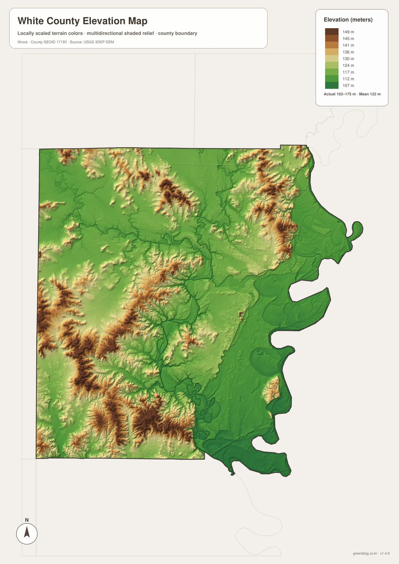
Carmi appears near the transition between these two broad terrain types. The strongest western ridges lie farther west, while the deepest eastern lowlands are closer to the river channels and county edge. Enfield and Norris City are surrounded by more frequent upland shading, whereas Grayville and the eastern side sit nearer green low terrain and major waterways. Mill Shoals is in the northwest, where low stream corridors cut between higher ground, so even the northern tier contains considerable local variation.
The elevation surface is generalized for county-scale interpretation. It is useful for seeing where ridges, valleys, and low river corridors occur, but it is not survey-grade or engineering-grade measurement. Exact elevations for construction, drainage design, property work, or site planning should come from detailed authoritative data or field measurements. Use this map to compare relative height across White County, not to replace a site survey.
Choosing the map that fits the question
Use the general map when a question combines communities, roads, and the county boundary. It is the clearest choice for locating Carmi and then tracing the main road directions toward Grayville, Enfield, Norris City, or New Haven. Use the city-distribution map when the road network would be distracting and the goal is simply to show where the six major labeled communities are positioned across the county.
For natural geography, the terrain-and-water map and elevation map work best as a pair. The water map supplies names such as Little Wabash River, Fox River, Skillet Fork, Flat Pond, and Old Channel Wabash River. The elevation map then shows whether those features occupy broad lowlands, narrow valleys, or areas close to higher ridges. If a lesson or report is about drainage, start with the water map. If it is about the contrast between western uplands and eastern lowlands, begin with the elevation map.
The WebP images in the article are optimized for convenient online viewing. The ZIP below contains the original high-resolution JPG versions, which are better suited to printing, zooming, or use on a larger screen. Each file emphasizes a different part of White County, so choosing the map that matches the task produces a clearer result than trying to use one map for every purpose.
Frequently Asked Questions
Which map is best for comparing Carmi, Grayville, and Norris City?
Use the general county map when you also need roads and boundary context. Use the city-distribution map when you want a cleaner comparison of settlement positions. Carmi lies in the interior, Grayville is at the northeastern edge, and Norris City is in the southwest. The city map does not provide driving distances, so current navigation information is still needed for actual travel planning.
Where can I see the Little Wabash River and the old Wabash channels?
The terrain-and-water map shows them most clearly. Little Wabash River crosses the northern and eastern part of the county, while Little Fox River and Fox River are prominent farther east. Old Channel Wabash River and Old River are also labeled near the eastern side. The map is intended for geographic reference and should not be used to determine flood risk, water depth, or navigation conditions.
Can the 102–175 m elevation map replace a site survey?
No. The 102–175 m range is designed to show relative relief across White County. It is useful for distinguishing the higher western ridges, the broad eastern lowlands, and the northeastern uplands, but it is not accurate enough for construction, drainage design, property work, or engineering. Those tasks require detailed authoritative elevation data or field measurements.
Map File Information
The ZIP package contains the high-resolution JPG versions of the White County general map, city-distribution map, terrain-and-water map, and elevation map. Review the web images above, then download the original-size files when you need printable or larger reference copies.
- Included Files: 4 high-resolution JPG maps
- Printable Size: 2572 × 3638 px each
Related Maps
Sources and References
The following official resources provide county background and supporting information for the boundary, hydrography, and elevation features shown on these maps.
- White County, Illinois official website — county government information and local background on I-64 and the Little Wabash River
- U.S. Census Bureau TIGER/Line Shapefiles — county boundary and geographic framework
- USGS National Hydrography — rivers, streams, and water-feature data
- USGS 3D Elevation Program — elevation and terrain data
Green Map creates custom-edited map images using open geographic data sources such as geoBoundaries, Natural Earth, OpenStreetMap, and government open data.
These maps are edited visual materials, not raw data files, and are provided for education, documents, presentations, and graphic reference.