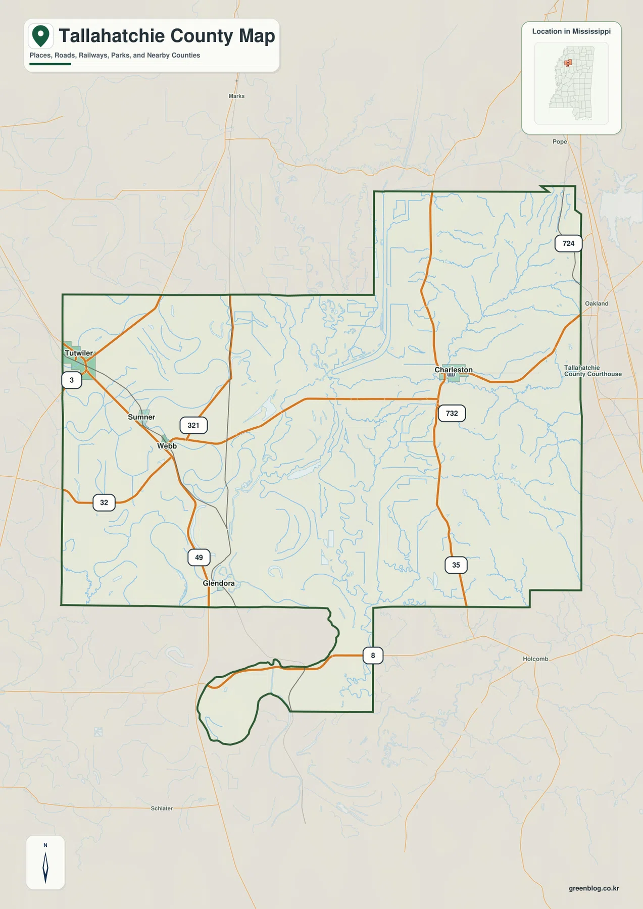
Tallahatchie County Map files are available to download directly from this page. The supplied maps show Charleston, Sumner, Tutwiler, Webb, and Glendora, along with the main road network, the Tallahatchie River system, smaller bayous and lakes, and elevation across a county with two very different landscapes. US 49E, MS 32, MS 35, and MS 3 provide useful road references. The downloadable ZIP contains the county, city, water, and elevation maps as high-resolution A3 JPG files.
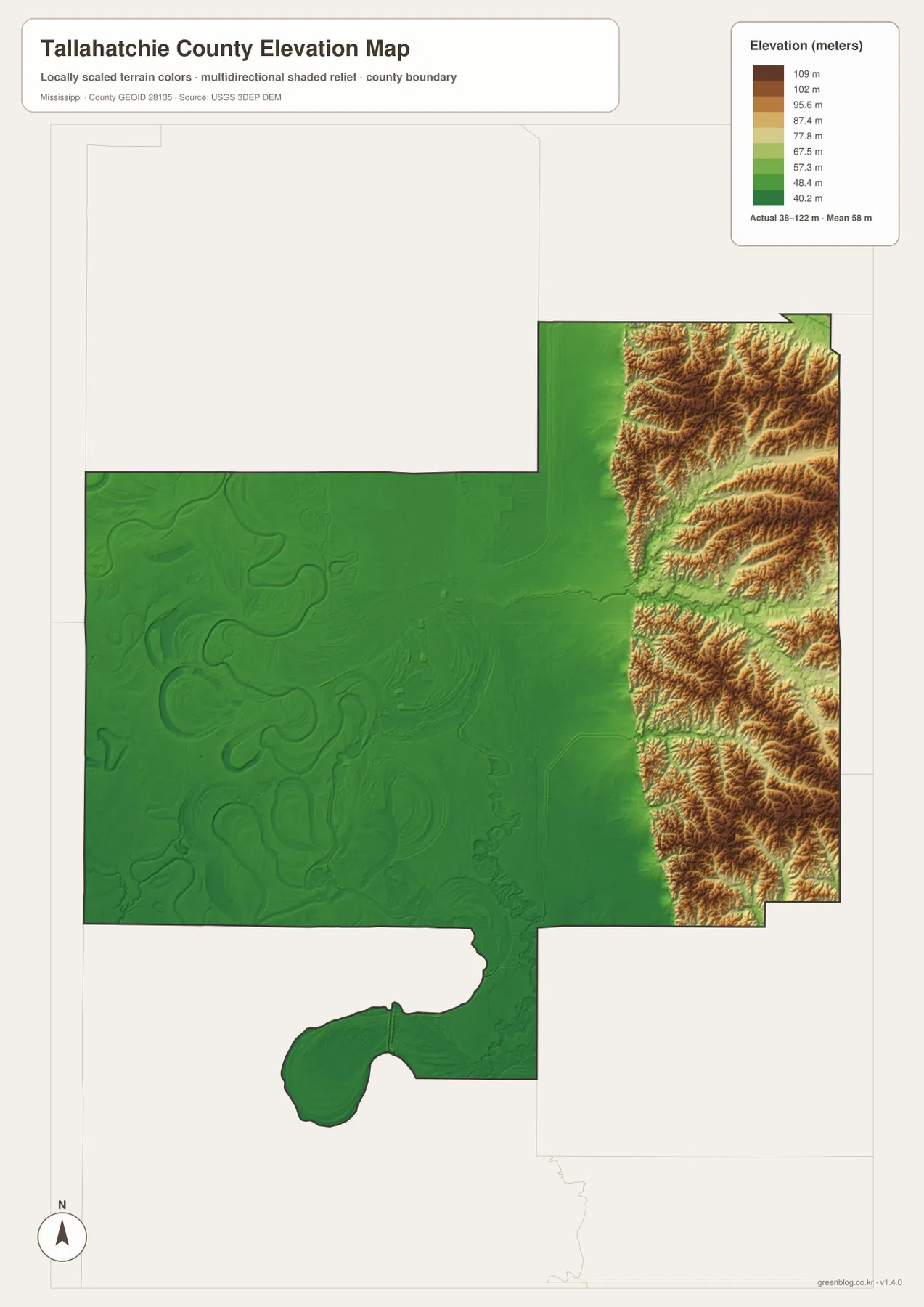
The county changes dramatically from west to east. Tutwiler, Sumner, Webb, and Glendora sit in the low Mississippi Delta, where broad flat terrain and large river bends dominate the map. Charleston lies farther east near the transition to a much hillier landscape. Tallahatchie River winds between those areas and becomes the best physical reference for understanding the county as a whole. The elevation map makes the contrast especially clear: a broad green plain occupies the west, while dense brown ridges rise in the eastern extension.
Table of Contents
Quick Facts
The Census figures supplied in the package list 12,715 residents in the 2020 census and a July 2025 estimate of 10,877. These values use different reference dates and methods, so they are best treated as separate benchmarks rather than identical measurements taken several years apart. Tallahatchie County’s FIPS code is 28135.
The supplied 2025 Gazetteer figures list 645.590 square miles of land and 6.552 square miles of water. Open water occupies only a small share of that total area, yet waterways have an outsized importance on the maps. Tallahatchie River, bayous, small lakes, and former-looking bends divide the western lowlands, while the eastern hills are cut by many short tributary valleys.
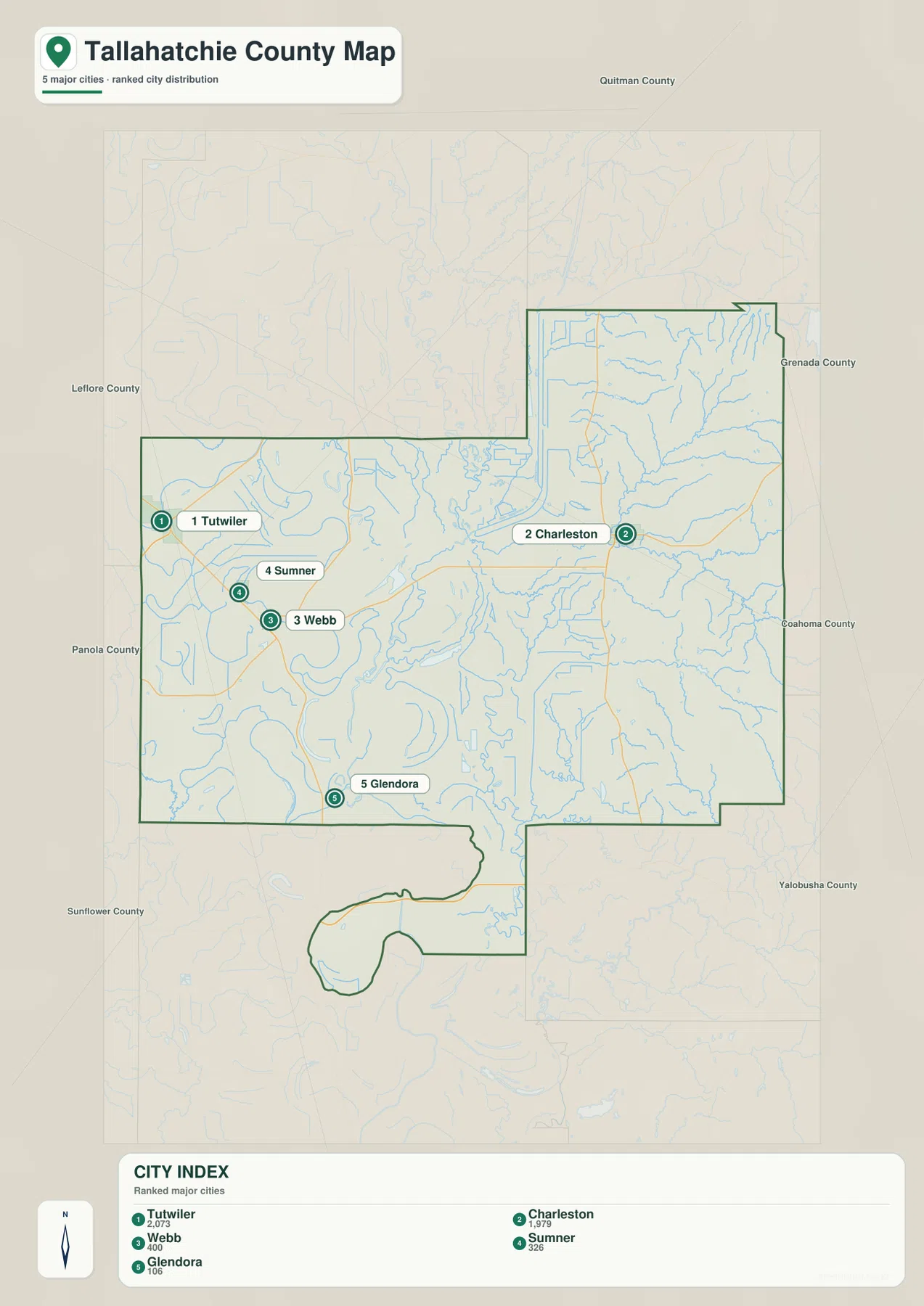
The ranked city map lists Tutwiler at 2,073 residents, Charleston at 1,979, Webb at 400, Sumner at 326, and Glendora at 106. Those values are useful for comparing the selected communities rather than substituting for the countywide population. Tutwiler is the largest place in this index and anchors the western Delta side, while Charleston provides the strongest urban reference in the eastern half. Charleston and Sumner are both important to the county’s administrative structure.
Reading the Tallahatchie County Mississippi map
Charleston is the easiest place to begin when reading the eastern half of the general county map. MS 35 runs north-south through the Charleston area, and MS 32 extends west toward Sumner and Webb. MS 724 appears in the northeastern section, while MS 732 is labeled south of Charleston. The road and stream patterns here are relatively intricate because the terrain is divided by many small valleys rather than laid out across one broad flat plain.
The western side has a different structure. US 49E provides the main north-south reference through the Tutwiler and Glendora side, while MS 3 is visible near Tutwiler. MS 32 and MS 321 help connect Sumner and Webb with the central portion of the county. Straight rural roads cross large flat areas, but river bends and drainage features introduce sweeping curves that are largely absent from the eastern road network.
The county boundary itself is complicated. A broad western block connects to a narrower eastern extension, and the southern edge contains an irregular protruding section. The city map labels Quitman, Grenada, Coahoma, Yalobusha, Sunflower, Panola, and Leflore counties around Tallahatchie County. Those outside references help explain why Charleston is associated with the hillier east while Tutwiler, Sumner, and Webb belong to the lower Delta side.
The city map removes most route detail and makes the settlement pattern easier to compare. Tutwiler sits close to the western edge, with Sumner and Webb grouped southeast of it. Glendora is farther south. Charleston is separated from those places by a long central stretch and sits east of the Tallahatchie River system. The five selected communities therefore do not form one continuous urban corridor; they create a western Delta cluster and a distinct eastern reference around Charleston.
Boundary, Water, and Terrain
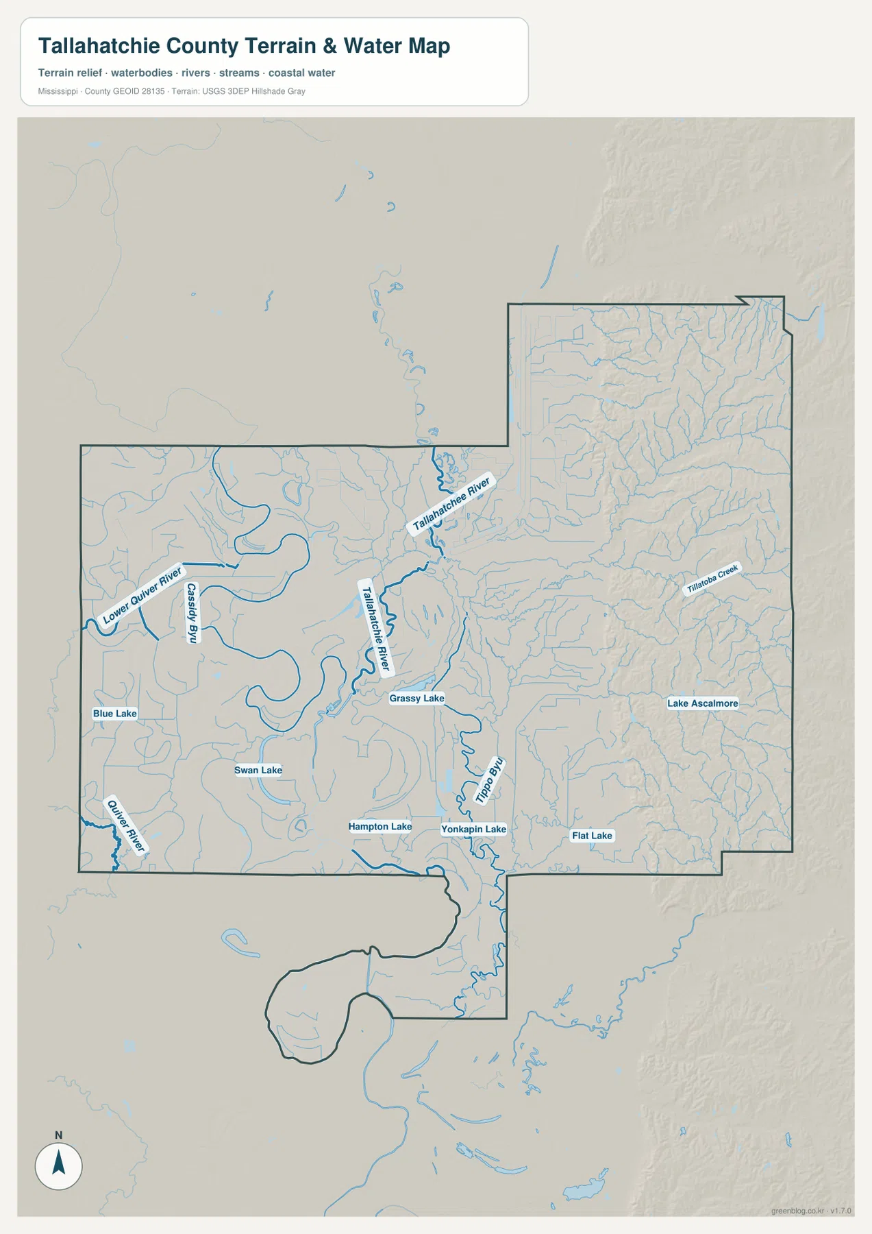
Tallahatchie River is the dominant named water feature on the terrain-and-water map. It crosses the central part of the county in large bends and links the flat western landscape with the drainage coming out of the eastern hills. Lower Quiver River is labeled on the west, and Cassidy Bayou follows another winding corridor nearby. Tippo Bayou becomes prominent farther south, while Tillatoba Creek and many smaller tributaries cut through the eastern side.
Several lakes provide additional landmarks. Blue Lake and Swan Lake appear in the western half, Grassy Lake lies close to the Tallahatchie River corridor, and Hampton Lake, Yankapin Lake, and Flat Lake are farther south. Lake Ascalmore is labeled in the eastern portion. No single reservoir dominates the county. Instead, the map shows many small water bodies distributed among river bends, low floodplain terrain, and hill-country drainage.
The elevation map prints an actual range of about 38 to 122 meters and a mean elevation of about 58 meters. Most of the western half and the central-southern lowlands are green, confirming the broad Delta plain. The eastern extension changes abruptly into tan and brown ridges with closely spaced valleys. The Charleston side therefore looks physically different from the Tutwiler-Sumner side even before city labels are added.
The Tallahatchie River corridor helps connect those two landscapes. West of the river, low floodplain forms and broad meander shapes are prominent. Eastward, smaller streams descend through narrow valleys between ridges. This elevation surface is generalized for county-scale comparison and should not be used as survey data for a farm, building site, levee, road grade, drainage design, or flood-risk decision. More detailed official data is required for those purposes.
Settlement and Regional Context
One of Tallahatchie County’s most unusual administrative features is that Charleston and Sumner are both treated as county seats in the supplied material. They are not neighboring centers within one continuous urban area. Charleston is on the eastern, hillier side, while Sumner lies in the western Delta. The map therefore gives each town a different geographic setting as well as a different role in understanding the county’s administrative history.
The external source catalog supplied with the package includes the National Park Service page for the Tallahatchie County Courthouse in Sumner. That reference is useful because it shows that Sumner is more than a small label on the city map; it is an important judicial and historical location. This page is not a dedicated history or visitor guide, so current access details and historical interpretation should be checked with the NPS source itself.
Tutwiler, Webb, and Glendora provide additional settlement references across the western agricultural landscape. Their surroundings are visually dominated by flat terrain, river bends, lakes, and drainage lines. Charleston’s surroundings are much more strongly shaped by wooded ridges and tributary valleys. That contrast is one of the clearest reasons to use all of the supplied map views rather than reducing the county to a short list of towns.
Practical Map Uses
Use the general county map when Charleston, Sumner, Tutwiler, major state routes, and the county boundary need to appear together. The city map is better for comparing the five selected communities without the extra road detail. Choose the water map when Tallahatchie River, Lower Quiver River, Tippo Bayou, or the named lakes are the main subject. The elevation map is the clearest option for explaining the dramatic difference between the western Delta plain and the eastern hill country.
For a classroom or presentation, the water and elevation maps make a particularly strong pair. One identifies the river, bayous, tributaries, and lakes; the other shows the low plain and the sudden rise into eastern ridges. If the topic is settlement or administration, the general map and city map work better together because they show why Charleston and Sumner are important in different parts of the county.
The WebP images on the page are optimized as previews. The high-resolution JPG originals in the archive are more suitable for printing and editing. These maps are general geographic references, not parcel surveys, flood-risk maps, levee assessments, engineering drawings, or live navigation products, so specialized current sources are still required for property, flood, construction, or real-time travel decisions.
Frequently Asked Questions
Does Tallahatchie County have only one county seat?
No. The supplied county material identifies both Charleston and Sumner as county seats associated with separate judicial and administrative districts. The map also places them in very different settings, with Charleston near the eastern hills and Sumner in the western Delta.
How do Charleston, Tallahatchie River, and the western Delta help orient the map?
Charleston is the clearest town reference for the eastern side, Tallahatchie River is the main physical feature crossing the middle, and Tutwiler-Sumner-Webb provide the strongest settlement references on the flat western side. Using those three geographic cues makes the county’s east-west contrast much easier to understand.
Map File Information
The ZIP contains the Tallahatchie County county, city, water, and elevation maps as high-resolution A3 JPG files. These originals are larger than the WebP page previews and are suitable for printing, editing, classroom materials, or location-reference graphics.
- File Type: four high-resolution JPG files in one ZIP
Related Maps
Sources
- U.S. Census Bureau QuickFacts for Tallahatchie County — population reference
- U.S. Census Bureau Gazetteer Files — land and water area reference
- Mississippi Department of Transportation Official Highway Map — US 49E, MS 32, MS 35, and other route references
- National Park Service Tallahatchie County Courthouse — Sumner courthouse and local history reference
- USGS National Hydrography — river, bayou, creek, and waterbody reference
- USGS 3D Elevation Program — elevation and terrain reference
Green Map creates custom-edited map images using open geographic data sources such as geoBoundaries, Natural Earth, OpenStreetMap, and government open data. These maps are edited visual materials, not raw data files, and are provided for education, documents, presentations, and graphic reference.