Sunflower County Map files are available to download directly from this page. The supplied maps show Indianola, Ruleville, Drew, Moorhead, Sunflower, and Inverness, along with the main road corridors, the county’s winding waterways, and elevation across the Mississippi Delta. US 49W and US 82 provide the clearest transportation references, while Big Sunflower River, Sunflower River, Quiver River, and Porter Bayou help explain the low alluvial landscape. The download ZIP contains the county, city, water, and elevation maps as high-resolution A3 JPG files.
Sunflower County stretches a long distance from north to south, and that shape matters when reading the map. Drew and Ruleville occupy the northern section, the City of Sunflower lies closer to the middle-south, and Indianola, Moorhead, and Inverness form the stronger southern cluster. The terrain is extremely low, with no mountain relief to organize the view. Instead, rivers, bayous, shallow lakes, straight farm-road corridors, and subtle elevation differences provide the most useful geographic structure.
Table of Contents
Quick Facts
The Census figures supplied in the package list 25,971 residents in the 2020 census and a July 2025 estimate of 22,893. These values use different reference dates and methods, so they are best read as separate benchmarks rather than identical measurements taken several years apart. Sunflower County’s FIPS code is 28133, and Indianola is the county seat.
The supplied 2025 Gazetteer figures list 697.759 square miles of land and 9.169 square miles of water. Dividing the 2020 population by that land area gives roughly 37.2 residents per square mile, but the number is only a countywide average. Indianola, Ruleville, and the other towns do not occupy the same kind of landscape as the broad farm fields, drainage corridors, and low river country between them.
The ranked city map lists Indianola at 9,062, Ruleville at 2,632, Drew at 2,132, Moorhead at 1,439, Sunflower at 976, and Inverness at 740. Those figures are useful for comparing the selected communities, not for replacing the countywide population total. The map makes Indianola the strongest southern urban reference, while Ruleville and Drew provide the clearest anchors for the long northern section.
Reading the Sunflower County Mississippi map
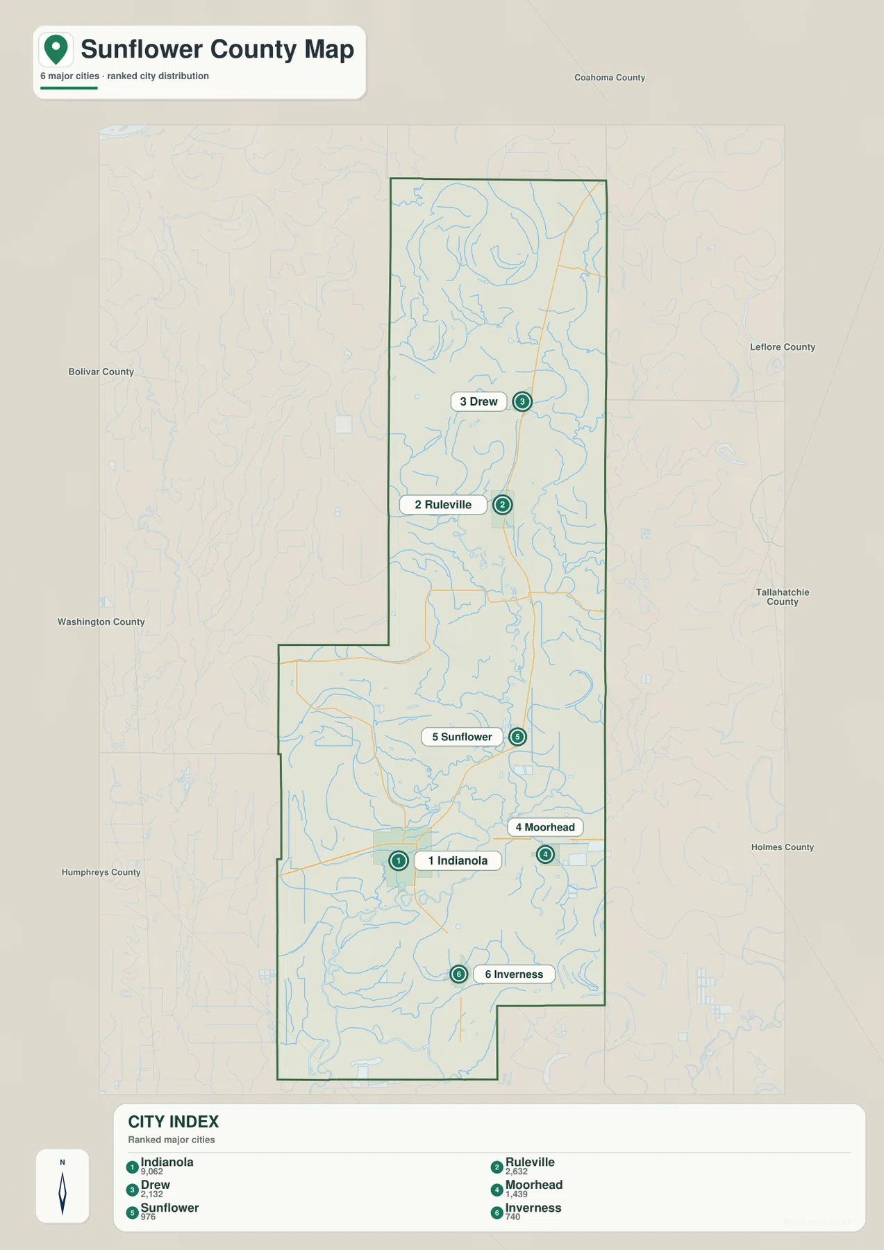
Indianola is the easiest place to begin on the general county map. US 82 runs east-west through the Indianola-Moorhead area, while US 49W forms the main north-south reference through the county. Following that route north leads toward Ruleville and Drew; following it south leads toward Inverness. MS 8 crosses the Ruleville area, MS 32 is visible in the far north, MS 442 appears across the western middle, and MS 448 is labeled near Indianola. MS 3 provides another route reference in the southeastern half.
The settlement pattern changes noticeably from north to south. Drew and Ruleville sit within the long upper section of the county. The City of Sunflower is farther south, and Indianola and Moorhead are relatively close to one another near US 82. Inverness lies still farther south. Because the county is elongated, a map centered only on Indianola can hide how far the northern towns and river bends extend away from the county seat.
The neighboring county labels add another layer of orientation. Coahoma County is north, Bolivar and Washington counties are west, Leflore and Tallahatchie counties are east, Humphreys County is southwest, and Holmes County is southeast. Those references make it easier to see how the Indianola-Moorhead corridor opens toward Leflore County and how the northern part of Sunflower County sits between the broader Bolivar-Coahoma side and the eastern Delta counties.
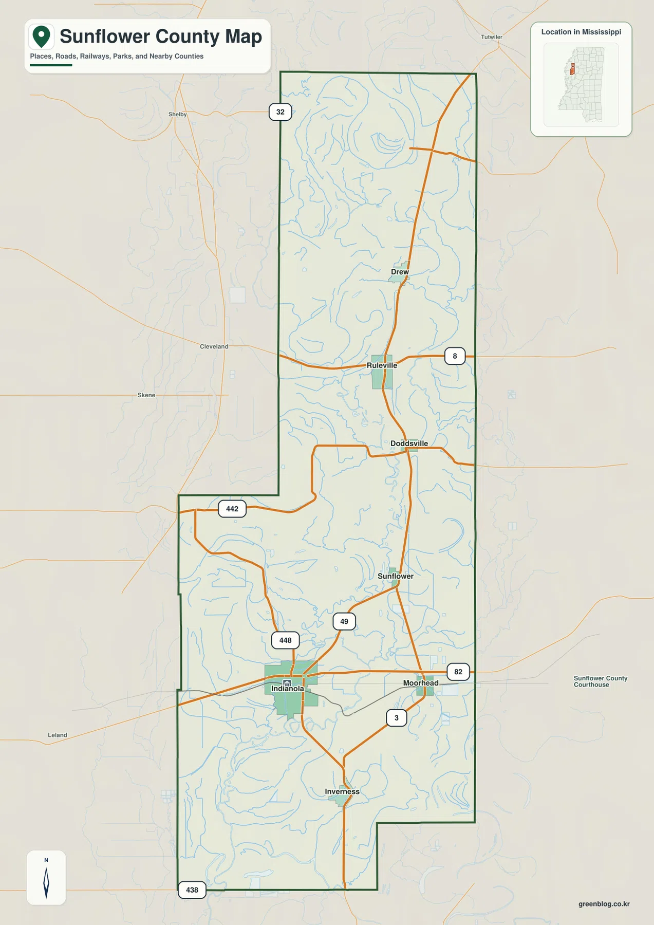
The city map strips away much of the road detail and emphasizes six ranked communities. Indianola is the largest and sits in the southern cluster. Moorhead is to the east, Inverness is farther south, and the City of Sunflower lies north of Indianola. Ruleville and Drew are separated from that cluster by a long central stretch of rural land. The map is therefore most useful for comparing town placement and relative scale rather than estimating exact driving distance.
Boundary, Water, and Terrain
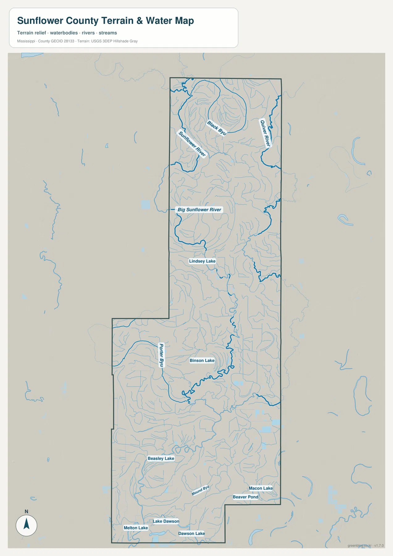
Big Sunflower River is the strongest named water feature on the supplied terrain-and-water map. It winds through the northern and central portions in broad curves rather than following a straight valley. A separate Sunflower River label appears farther north, Quiver River follows the northeastern side, and Black Bayou is labeled in the upper section. Their shapes contrast sharply with the rectilinear road and field pattern that characterizes much of the Delta.
Porter Bayou becomes prominent farther south, where the drainage network grows increasingly intricate. Lindsey Lake is labeled in the north-central area and Binson Lake farther south. Beasley Lake appears in the lower half, and the southern end includes Macon Lake, Beaver Pond, Lake Dawson, Dawson Lake, and Melton Lake. These water bodies do not form one dominant reservoir. Instead, they are scattered among river bends, bayous, and low drainage corridors.
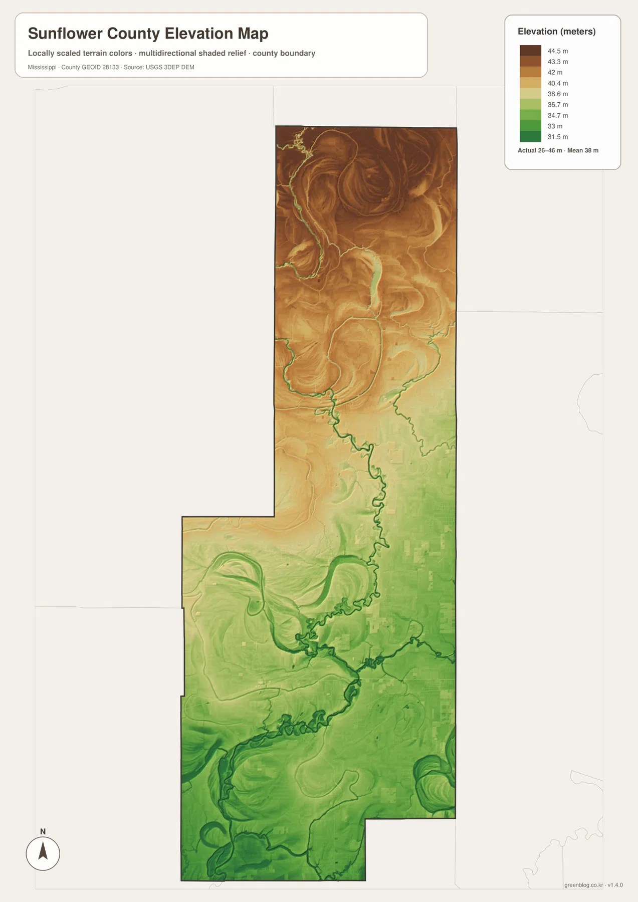
The elevation map prints an actual range of about 26 to 46 meters and a mean elevation of about 38 meters. The north is generally shown in warmer tan and brown colors, indicating slightly higher ground, while greener low terrain becomes more extensive toward the center and south. Big Sunflower River and the southern waterways occupy especially clear low corridors. The total elevation difference is small, but in an extremely flat Delta county, even those few meters help distinguish river-related low ground from slightly higher parts of the plain.
Large curved and crescent-shaped terrain bands also appear on the elevation map. Some follow present waterways while others sit nearby, which makes them useful clues to the county’s river-shaped landscape. The map alone should not be used to classify a specific feature as an abandoned channel, determine flood risk, or establish levee height. Property-scale elevation, drainage design, and flood decisions require more detailed official data.
Settlement and Regional Context
Indianola is both the county seat and the largest city shown in the supplied ranking. Its position at the US 82 and US 49W area makes it the natural starting point for explaining Moorhead, Inverness, the City of Sunflower, Ruleville, and Drew. The existing source material also identifies Mississippi Delta Community College in Moorhead, adding an educational reference to the eastern part of the southern city cluster.
The shared name between Sunflower County and the City of Sunflower can be confusing. Sunflower is a small city within the county, but it is not the county seat. The city map places it north of Indianola, making the distinction easy to see visually. Using the county name and city name carefully is especially important in searches, captions, and directions.
Indianola is also strongly associated with Delta blues history. The source catalog supplied with the package includes the B.B. King Museum and Delta Interpretive Center, which provides a cultural reference beyond roads and administrative geography. The map on this page is not a tourism map, so current museum hours, exhibits, or event information should be checked with the museum itself.
Much of the space between the towns is agricultural land crossed by drainage lines and waterways. The low elevation and dense water network are visually important, but these maps do not show crop types, farm ownership, irrigation rights, or parcel boundaries. Their purpose is to explain the relationship among towns, roads, water, and the broad Delta terrain rather than provide farm-management or property information.
Practical Map Uses
Use the general county map when the county boundary, US 49W, US 82, Indianola, Ruleville, Drew, and the other place names need to appear together. The city map is better for comparing the six selected communities without extra road detail. Choose the water map when Big Sunflower River, Quiver River, Porter Bayou, or the named lakes are the main subject. The elevation map is the clearest option for showing how little the county rises overall and where the lower river corridors appear.
For a classroom or presentation, the general and city maps make a useful pair for explaining the long north-south settlement pattern. The water and elevation maps work better together for physical geography: one identifies the winding waterways and lakes, while the other shows the subtle low corridors and slightly higher ground around them. This pairing makes the Delta landscape easier to understand without relying on abstract terrain terminology.
The WebP images on the page are optimized as previews. The high-resolution JPG originals in the archive are more suitable for printing and editing. These maps are general geographic references, not parcel surveys, flood-risk maps, drainage-engineering plans, or live navigation products, so specialized current sources are still required for property, flood, construction, or real-time travel decisions.
Frequently Asked Questions
Is the Town of Sunflower the county seat?
No. The City of Sunflower is a smaller community north of Indianola, while Indianola is the county seat. The shared county and city name can be confusing, so the city-distribution map is useful for separating the two geographically.
Why is Indianola alone insufficient for interpreting Sunflower River near Coahoma?
Indianola is in the southern half of the county, while the Sunflower and Big Sunflower river system extends far north through a much larger landscape toward the Coahoma County side. A city label therefore cannot explain the northern river bends or the relationship among Ruleville, Drew, Quiver River, and the county boundary. The full water map is needed for that wider view.
Map File Information
The ZIP contains the Sunflower County county, city, water, and elevation maps as high-resolution A3 JPG files. These originals are larger than the WebP page previews and are suitable for printing, editing, classroom materials, or location-reference graphics.
- File Type: four high-resolution JPG files in one ZIP
Related Maps
Sources
- U.S. Census Bureau QuickFacts for Sunflower County — population reference
- U.S. Census Bureau Gazetteer Files — land and water area reference
- Mississippi Department of Transportation Official Highway Map — US 49W, US 82, and state-route reference
- USGS National Hydrography — river, bayou, and waterbody reference
- USGS 3D Elevation Program — elevation and terrain reference
- B.B. King Museum and Delta Interpretive Center — Indianola cultural reference
Green Map creates custom-edited map images using open geographic data sources such as geoBoundaries, Natural Earth, OpenStreetMap, and government open data. These maps are edited visual materials, not raw data files, and are provided for education, documents, presentations, and graphic reference.