Tippah County map files can be downloaded directly from this page. The supplied maps show Ripley, Walnut, Falkner, Blue Mountain, and Dumas, together with the county’s main road references, river systems, and elevation. MS 15 provides a strong north-south line through several communities, while US 72 crosses the northern area near Walnut. The water map adds Little Hatchie River, Hatchie River, Tippah River, Little Tallahatchie River, and a dense creek network, and the elevation surface shows an actual range of roughly 113 to 240 meters. The archive below contains the county, city, water, and elevation maps as high-resolution A3 JPG files.
Although Tippah County reaches the Tennessee state line, the border alone does not explain the county’s geography. Ripley sits south of center and works as the main road and settlement reference. Falkner and Walnut extend the county northward, while Blue Mountain and Dumas occupy different parts of the south. Between these places, wooded ridges rise above narrow stream valleys. The road, water, and elevation views therefore work best as a set: roads explain movement, streams reveal the valleys, and the elevation map shows why the terrain becomes rougher in the northwest and southeast.
Table of Contents
Ripley as the reference point for county scale
The Census material supplied with the package lists 21,815 residents in the 2020 census and a July 2025 estimate of 21,389. Those values come from different reference dates and methods, so they work best as separate population benchmarks. The 2025 Gazetteer figures list 457.822 square miles of land and 2.132 square miles of water. Using the 2020 count and the listed land area produces about 47.6 residents per square mile, a countywide average that does not describe the large differences between towns, farms, woods, and stream valleys.
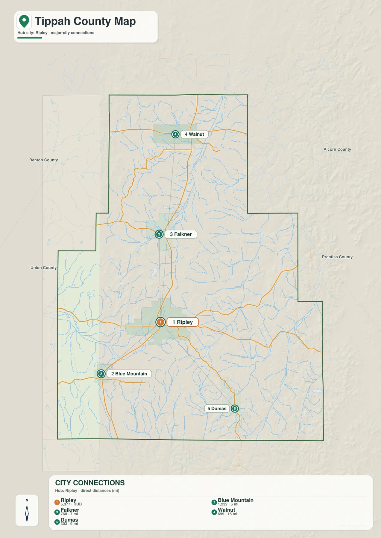
The city-connections map makes the internal spacing much easier to see. Ripley is the hub and is listed at 5,377 residents. Blue Mountain is shown at 1,232 and about 6 miles from Ripley by straight-line distance, Falkner at 760 and about 7 miles, Dumas at 303 and about 9 miles, and Walnut at 699 and about 15 miles. These are direct map distances rather than driving mileage, but they make the elongated north-south shape of the county easy to understand.
Blue Mountain and Falkner are relatively close to Ripley but lie in different directions. Walnut is much farther north and acts as the clearest settlement reference near the Tennessee side, while Dumas anchors the southeastern rural area. Benton County lies to the west, Alcorn County to the east-northeast, Prentiss County to the southeast, and Union County to the southwest. The northern edge of Tippah County meets Tennessee, completing a county outline that is noticeably taller than it is wide.
MS 15, US 72, and the road pattern through the county
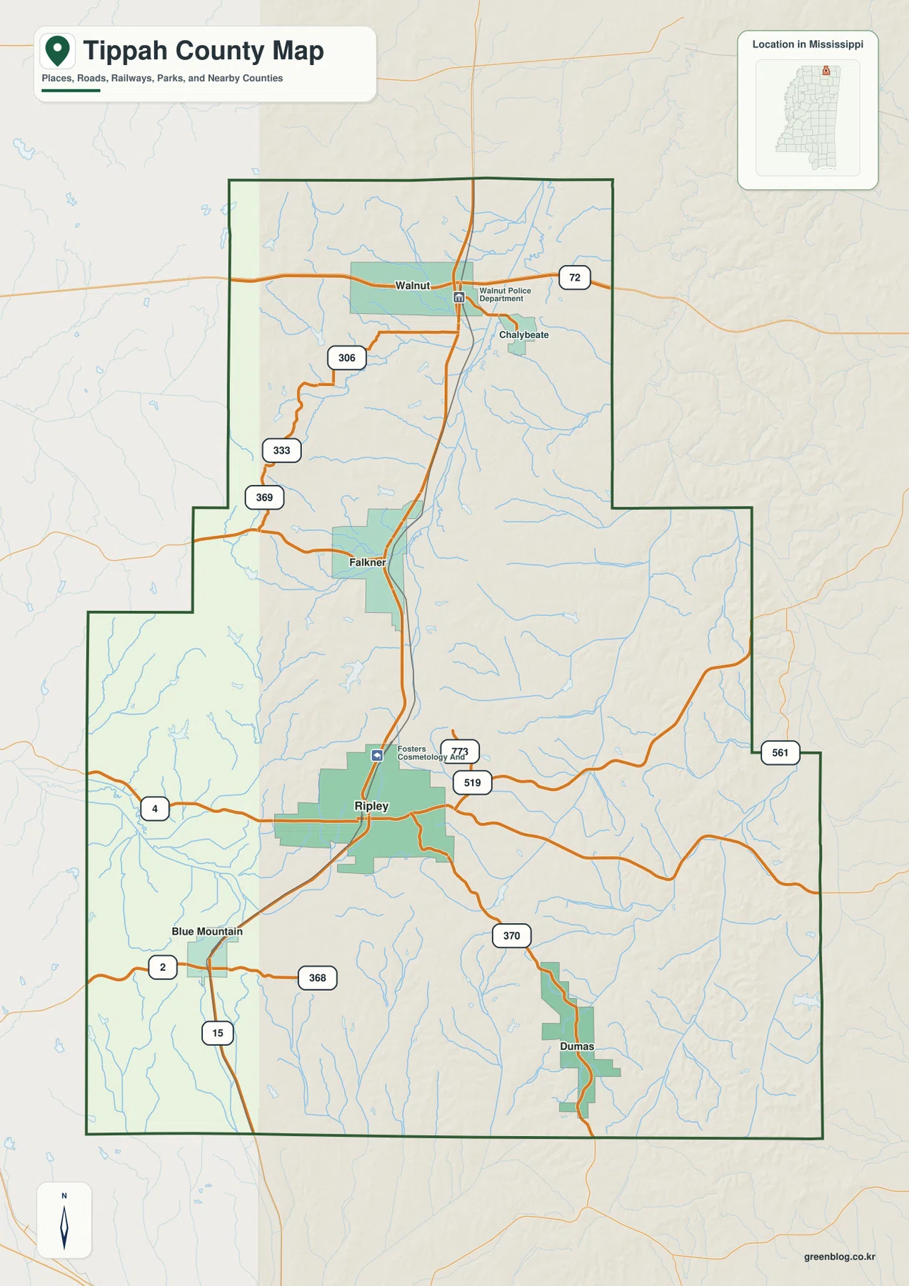
MS 15 is the easiest route to follow on the general county map because it ties several of the major communities together. From the Blue Mountain side it runs through the Ripley corridor and continues north through Falkner toward Walnut and the Tennessee direction. US 72 crosses the north near Walnut and provides the strongest east-west route there. MS 4 crosses the Ripley area, while MS 2 provides another east-west reference near Blue Mountain.
The northwestern road pattern includes MS 306, 333, and 369, which connect rural areas west of Walnut and Falkner. East of Ripley, MS 519 and MS 773 are visible, with MS 561 farther toward the eastern county edge. MS 370 runs toward the Dumas side, and MS 368 appears near Blue Mountain. The map does not attempt to show every farm lane or local road, but it clearly separates the main routes that organize travel from the smaller roads winding through the hills.
A few facility labels add local context. Forrest’s Cosmetology and Barber College appears in the Ripley area, and the Walnut Police Department is marked in the north. These labels are useful for locating the centers of the communities rather than for checking current business hours or public-service availability. The road map should likewise be treated as a county-scale reference, not a substitute for current navigation.
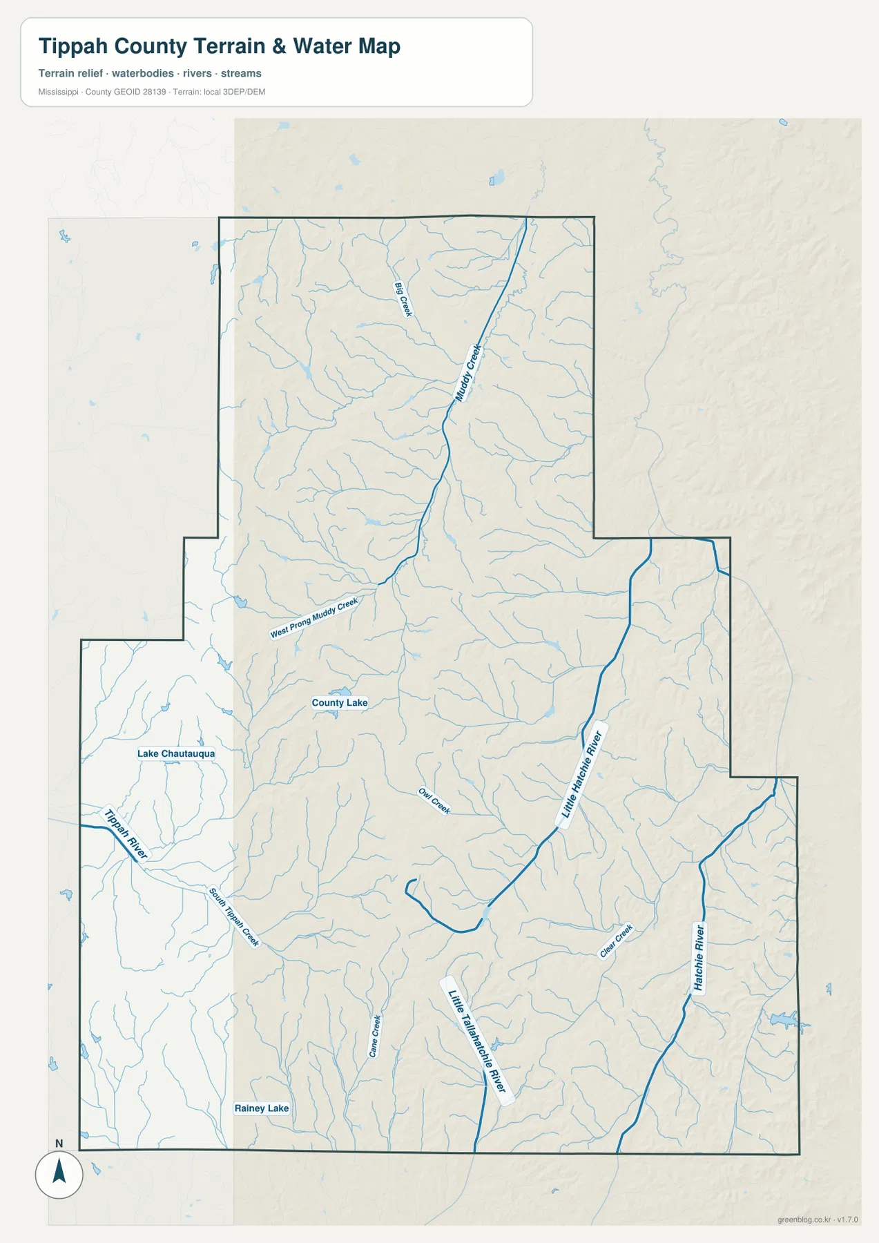
Little Hatchie River, Tippah River, and separate drainage valleys
Little Hatchie River is one of the strongest named waterways on the supplied terrain-and-water map. It runs through the central-eastern part of the county and continues south, collecting many short tributaries from the surrounding hills. Hatchie River appears separately along the eastern side. In the north, Muddy Creek and Big Creek are labeled, and West Prong Muddy Creek crosses farther south before joining the larger drainage pattern.
The western side belongs to a different set of waterways. Tippah River curves through the southwest, close to Lake Chautauqua and County Lake. South Tippah Creek approaches from the Ripley side, while Cane Creek and Rainey Lake appear farther south. Owl Creek is labeled nearer the middle. The southern part of the county also contains Little Tallahatchie River, making it clear that Tippah County is divided among several stream systems rather than drained by one dominant river.
Clear Creek occupies part of the east and connects visually with the Hatchie side of the map. Numerous unnamed or smaller tributaries descend from nearby ridges toward Little Hatchie River and the other larger channels. There is no county-dominating reservoir in the supplied map. Instead, the landscape is a close network of creeks, narrow valleys, and a few small lakes, which is one reason the terrain map looks much more intricate than the road map.
A 113–240 meter landscape of ridges and narrow valleys
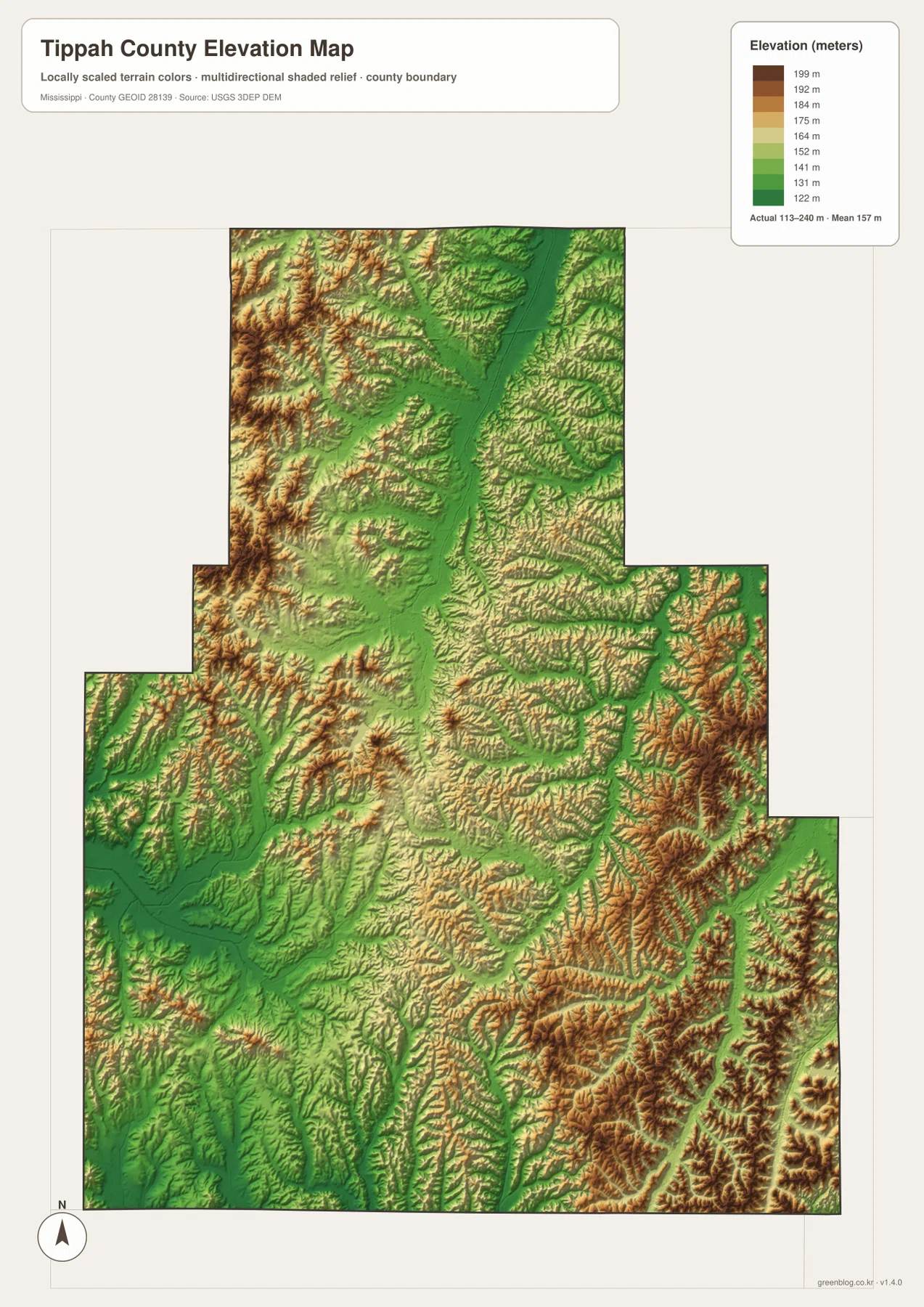
The elevation map prints an actual range of about 113 to 240 meters and a mean elevation of about 157 meters. High brown terrain is especially noticeable in the northwest, while a long green valley crosses the north-central area along the Muddy Creek system. Around Ripley, relief is generally more moderate. Farther east and southeast, tightly spaced ridges rise again and create some of the roughest terrain on the map.
The southwest is lower around Tippah River and South Tippah Creek, and green corridors also extend through the Blue Mountain side. In contrast, ridges east and southeast of Dumas are strongly defined. The place name Blue Mountain can sound as if it refers to one isolated mountain, but the elevation map shows a broader hill country made of many ridges and valleys rather than a single dominant peak.
Placing the water and elevation maps side by side shows why the streams take their routes. Little Hatchie River, Tippah River, and Little Tallahatchie River all occupy lower corridors, while the land between them rises into irregular ridges. The elevation colors are intended for countywide comparison; exact property elevations, road grades, drainage design, construction work, and flood decisions require more precise source data.
Ripley, Blue Mountain, and the county’s local reference points
Ripley is the county seat and the most useful starting point for local orientation. MS 15 leads north toward Falkner and Walnut and south toward the Blue Mountain side, while MS 4 and several other state routes spread east and west. The city-connections map also uses Ripley as its hub, so distances and settlement directions can be compared without changing reference points from one map to the next.
Blue Mountain is a community southwest of Ripley, not simply the name of a mountain on this map. The source list supplied with the package includes Blue Mountain Christian University, giving the town an educational reference that is easy to connect with the general map. The surrounding relief is genuinely hilly, but the county elevation view does not identify one isolated summit called Blue Mountain.
Walnut is important because it sits near US 72 and the northern end of the MS 15 corridor, making it a useful reference for the Tennessee side of the county. Falkner lies between Walnut and Ripley on the same broad north-south pattern. Dumas serves a different role in the southeast, where the terrain becomes more strongly dissected by ridges and stream valleys. These relationships explain the community layout better than a simple list of place names.
Choosing the map that fits the question
Choose the general county map when roads, boundaries, and several place names need to appear together. The city-connections map is better for comparing Ripley with Blue Mountain, Falkner, Walnut, and Dumas and for using the printed straight-line distances. The water map is the strongest choice for Little Hatchie River, Tippah River, Little Tallahatchie River, and the named lakes. The elevation map is the clearest way to explain how narrow valleys cut through higher wooded ridges.
For a classroom or presentation, pairing the general map with the city-connections map keeps the focus on Ripley and the surrounding communities. If the subject is physical geography, the water and elevation views are more revealing together because the low stream corridors can be matched directly with the named rivers and creeks. This makes the county’s hill-and-valley pattern easier to understand without relying on technical GIS language.
The WebP images in the article are sized for quick on-page viewing. For an A3 print, editing work, or a larger classroom graphic, use the high-resolution JPG originals in the ZIP below. These maps are general geographic references rather than parcel surveys, engineering plans, flood maps, or live navigation products, so more specialized current sources are needed for property, construction, flood, or real-time travel decisions.
Frequently Asked Questions
Does Tippah County directly border Tennessee?
Yes. The northern boundary of Tippah County meets Tennessee. Walnut is the strongest community reference near that side of the county, and US 72 plus MS 15 make the northern road pattern easy to locate. Detailed property or roadway boundary questions still require a more precise official boundary source.
Is Blue Mountain the name of a mountain on this map?
On these maps, Blue Mountain is the name of a community southwest of Ripley. The surrounding countryside is hilly, but the supplied elevation map does not identify a single isolated mountain peak by that name. MS 15 and MS 2 provide useful road references for locating the community.
Map File Information
The ZIP contains the Tippah County county, city, water, and elevation maps as high-resolution A3 JPG files. The originals preserve more detail than the WebP page previews and are suitable for printing, editing, classroom materials, or location-reference graphics.
- File Type: four high-resolution JPG files in one ZIP
Related Maps
Sources and References
- U.S. Census Bureau QuickFacts for Tippah County — population reference
- U.S. Census Bureau Gazetteer Files — land and water area reference
- Mississippi Department of Transportation Official Highway Map — MS 15, US 72, and state-road reference
- USGS National Hydrography — Little Hatchie River, Tippah River, creeks, and lakes
- USGS 3D Elevation Program — elevation and terrain reference
- Blue Mountain Christian University — Blue Mountain local institution reference
Green Map creates custom-edited map images using open geographic data sources such as geoBoundaries, Natural Earth, OpenStreetMap, and government open data. These maps are edited visual materials, not raw data files, and are provided for education, documents, presentations, and graphic reference.