Lafourche Parish stretches from the developed area around Thibodaux through a long chain of communities to marshes and open coastal water in southern Louisiana. Bayou Lafourche and the main road corridor run through much of that length, while the southern end becomes increasingly dominated by canals, bayous, wetlands, and bays. This page separates those layers into a parish road-and-place map, a city-connections map, and a terrain-and-water map. Matching high-resolution JPG files are also available together in a downloadable ZIP.
Thibodaux is the easiest place to use as a northern reference point. Louisiana’s official parish profile identifies it as the parish seat, and the same north-to-south sequence visible on the map continues through Raceland and Lockport toward Larose, Cut Off, Galliano, and Golden Meadow. The result is a parish whose inhabited places do not form one compact cluster. Instead, many of the best-known communities follow a long corridor beside Bayou Lafourche before the landscape opens into the coastal wetlands.
Table of Contents
A long settlement corridor runs south from Thibodaux
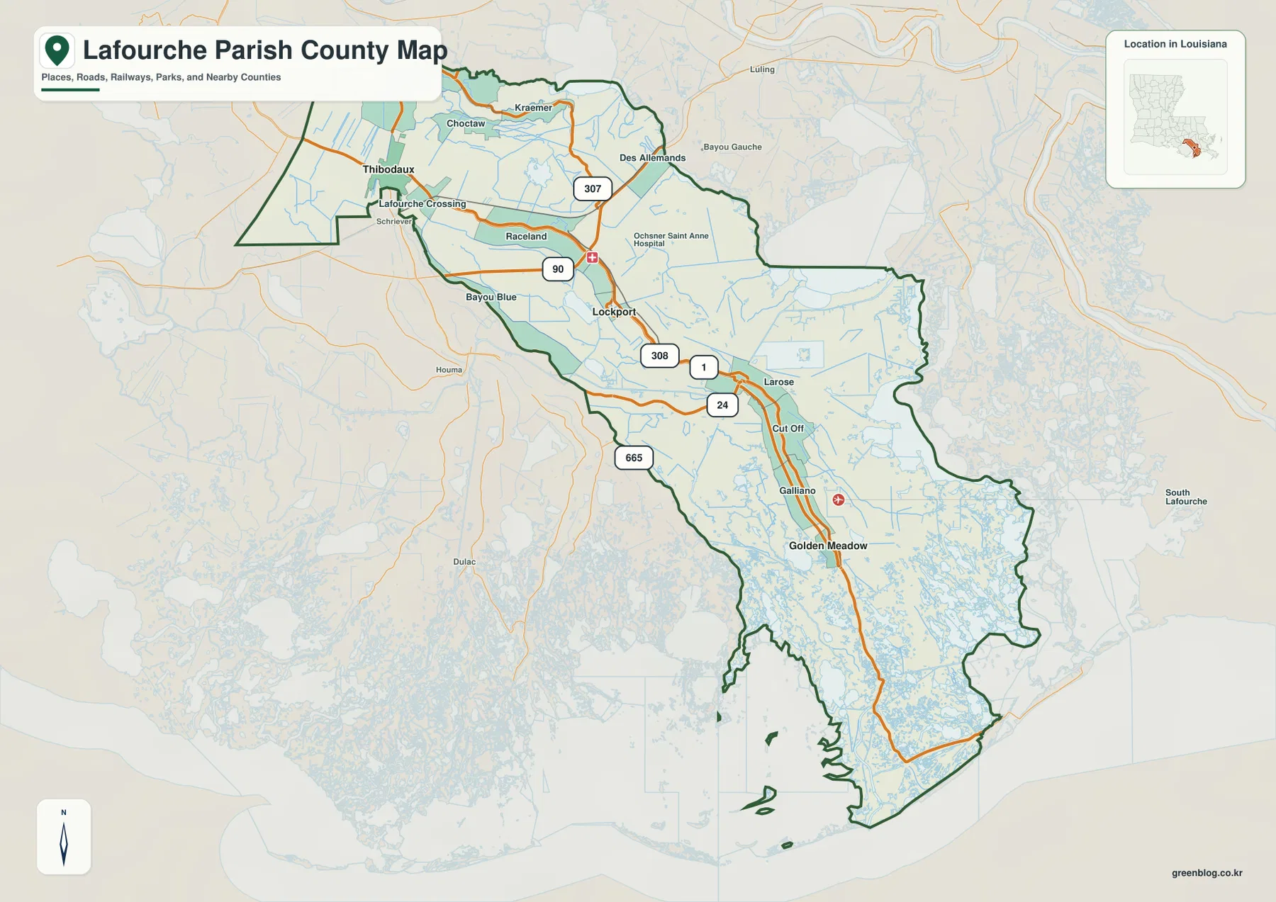
The general parish map makes the unusual shape of Lafourche clear. Thibodaux occupies the northwestern end, with Lafourche Crossing and Raceland nearby. Lockport appears farther southeast, followed by Larose, Cut Off, Galliano, and Golden Meadow along the narrower central and southern portion of the parish. Looking at these names in sequence is more useful than treating them as isolated points, because their arrangement explains why the parish feels elongated even before the coast comes into view.
South of Golden Meadow, labeled communities become less frequent while water channels become much more numerous. The parish boundary also grows more irregular as it approaches the coast, bending around wetland and water features instead of following a simple rectangular outline. That contrast between the northern settled land and the southern marsh makes the full parish map especially valuable for orientation. A reader can see both the road-connected communities and the much less urban coastal end without switching scales.
LA 1 and LA 308 follow the heart of the parish
Road labels help explain how the inhabited corridor is organized. LA 1 and LA 308 are prominent through the central part of the map, staying close to the Bayou Lafourche corridor as they continue through or near Lockport, Larose, Cut Off, Galliano, and Golden Meadow. Farther north, LA 90 and LA 307 connect Raceland with surrounding areas, while LA 24 and LA 665 appear on the western side of the parish. The routes are easy to distinguish from the waterways because the main roads are drawn in orange and the drainage network in blue.
This is not a turn-by-turn road map, but it works well for understanding which communities belong to the same broad travel corridor. Thibodaux, Lockport, and Golden Meadow are separated by substantial distance, yet the road pattern shows that they remain linked by the same general north-south geography. Smaller places such as Raceland, Larose, Cut Off, and Galliano fill the spaces between them. For current travel times, closures, or bridge conditions, a live navigation source is still necessary.
The city-connections map compares three points along that corridor
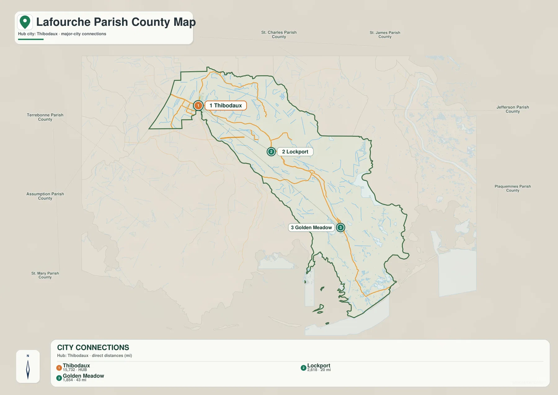
The city-connections view simplifies the parish to three reference places. Thibodaux is the hub and is labeled number 1, Lockport is number 2, and Golden Meadow is number 3. The legend lists Lockport at about 20 miles from Thibodaux and Golden Meadow at about 43 miles. Those figures are straight-line distances between the mapped places, not driving distances along LA 1, LA 308, or any other route.
The value of this map is less about precise travel planning and more about scale. Thibodaux represents the northern population center, Lockport marks a middle section of the settled corridor, and Golden Meadow sits much farther south near the transition to the coastal landscape. With most smaller labels removed, the long geometry of Lafourche Parish becomes easier to see. It is a useful graphic when a presentation or lesson needs a quick comparison of the parish’s northern, central, and southern community positions.
Bayou Lafourche links the settled north with the wetland south
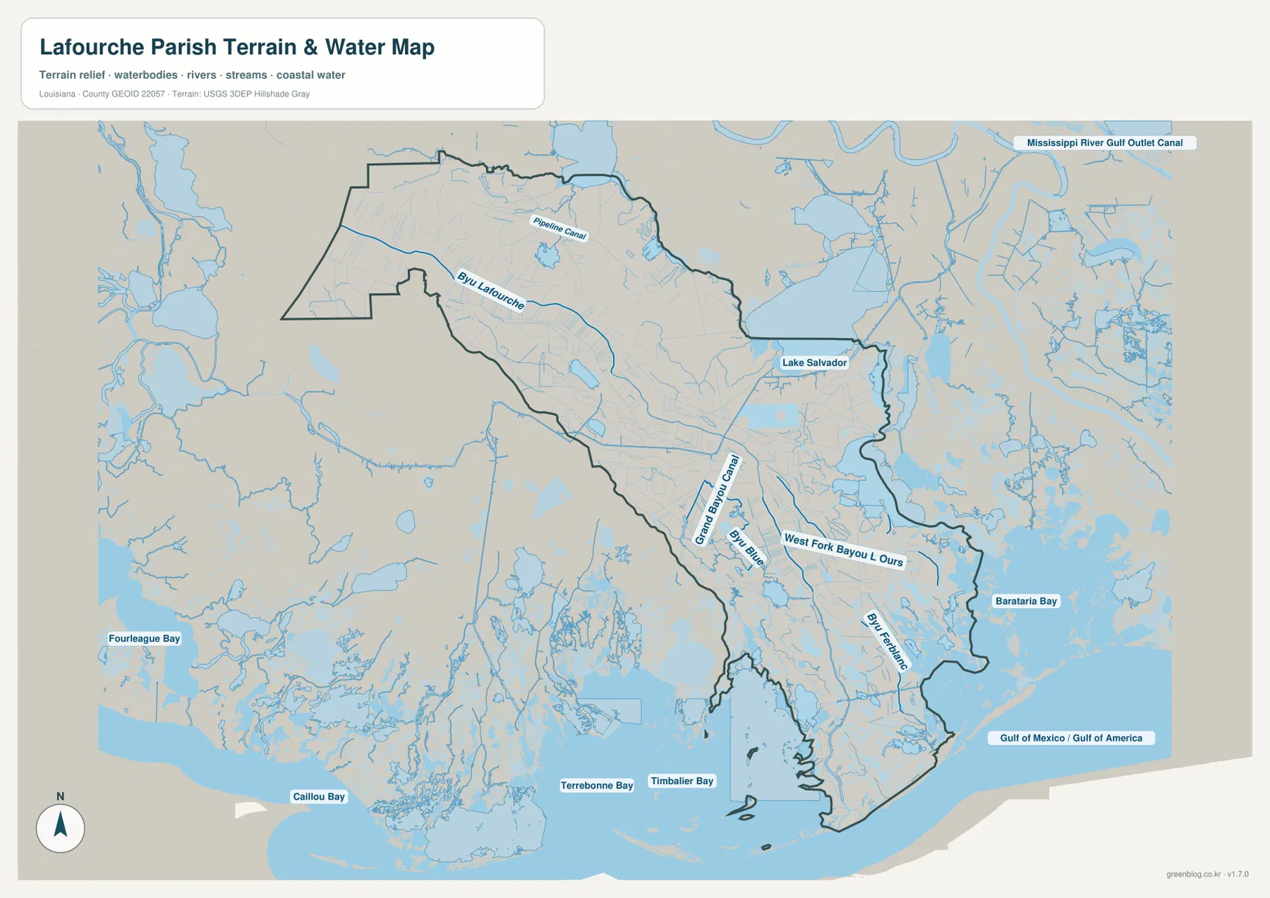
On the terrain-and-water map, Bayou Lafourche is the defining named waterway. It crosses the parish in the same general direction as the main settlement corridor and continues toward the coast. That alignment helps explain why the road-and-place map and the water map tell related stories: many communities occupy ground close to the bayou, while the surrounding hydrology grows denser farther south. The parish government’s background page also notes the historic importance of Bayou Lafourche to settlement, transportation, and fresh water.
Lake Salvador stands out near the eastern side of the upper-middle parish. Grand Bayou Canal, West Fork Bayou L’Ours, Bayou Blue, and Bayou Folse are also labeled, and numerous smaller channels appear around them. In this view, the developed corridor occupies only part of the parish’s physical setting. The blue network becomes progressively more prominent toward the lower half, showing how quickly the landscape changes from road-centered communities to a web of natural and artificial waterways.
Timbalier Bay opens the map into a broad coastal landscape
Near the southern end, Timbalier Bay appears along the coast, while Terrebonne Bay and Caillou Bay are visible to the west outside the parish and Barataria Bay lies to the east. The map also includes a wide area of small channels, ponds, marsh openings, and coastal water. These features make the lower parish look fundamentally different from the Thibodaux and Raceland area. Instead of a few dominant roads crossing solid land, the map becomes a dense mixture of water and wetland edges.
The water layer should be used as a geographic reference rather than as a flood, navigation, or property map. A blue area does not by itself indicate a flood-hazard classification, safe boating depth, navigability, or a legal boundary. Anyone making decisions about flooding, levees, navigation, wetland permits, or property should consult the appropriate current federal, state, and local sources. Here, the purpose is to show where the major named waterways and coastal water bodies sit in relation to the parish boundary.
Read the parish in two parts for a clearer sense of scale
Because Lafourche Parish is long and narrow, the northern and southern halves reward different kinds of attention. In the north, Thibodaux, Raceland, Lockport, LA 90, LA 1, and LA 308 provide strong landmarks. Moving south, the sequence through Larose, Cut Off, Galliano, and Golden Meadow is the easiest way to stay oriented. Beyond that, named communities become less useful than bays, bayous, canals, and the shape of the coastline.
Switching between the general map and the water map makes that transition much easier to understand. A road-focused view is best around Thibodaux and the central communities, while the water layer adds much more information in the southern marsh. The city-connections map then provides a stripped-down scale reference by placing Thibodaux, Lockport, and Golden Meadow on the same long axis. Together, the three maps show why no single layer describes the entire parish equally well.
The original JPG files preserve small road and water labels
The downloadable ZIP contains the three original JPG files that correspond to the previews on this page: the general parish map, the city-connections map, and the terrain-and-water map. Each original image is 3638 by 2572 pixels, giving more room to enlarge road numbers, place names, and water labels than the web preview. That makes the originals useful for printing, classroom material, presentations, or personal geographic reference.
Choose the general map when roads, boundaries, and the full chain of communities matter most. Use the city-connections graphic for a quick comparison of Thibodaux, Lockport, and Golden Meadow, and use the water map when Bayou Lafourche, Lake Salvador, central canals, or the coastal bays are the main topic. These files are reference maps rather than legal, surveying, engineering, flood-risk, or real-time navigation products.
Frequently Asked Questions
Which places are the best starting points for reading the Lafourche Parish map?
Start with Thibodaux in the north, then follow the corridor through Raceland and Lockport toward Larose, Cut Off, Galliano, and Golden Meadow. Louisiana’s official parish profile identifies Thibodaux as the parish seat and lists Lockport and Golden Meadow among the parish’s incorporated towns. Following the communities in that order also matches the parish’s long north-to-south shape.
Are the 20-mile and 43-mile labels driving distances?
No. The city-connections legend uses direct straight-line distances from the Thibodaux hub to Lockport and Golden Meadow. Actual road mileage is longer because roads follow the bayou, bridges, bends, and local connections. Use a current navigation service when exact driving distance or travel time matters.
Can the terrain-and-water map be used as a flood or navigation map?
No. It is a general geographic reference showing waterways and coastal water bodies such as Bayou Lafourche, Lake Salvador, and Timbalier Bay. It does not provide flood-zone ratings, water depth, navigability, levee-protection status, or legal property boundaries, so specialized decisions require current official data from the responsible agencies.
Map File Information
The ZIP contains the original high-resolution JPG files corresponding to the general parish map, city-connections map, and terrain-and-water map shown on this page.
- Included Files: parish map JPG, city-connections map JPG, terrain-and-water map JPG
Related Maps
Sources and references
For local background and administrative information, see the Louisiana.gov Lafourche Parish Profile and Lafourche Parish Government’s About Our Parish page. General boundary data are available from the U.S. Census Bureau TIGER/Line Shapefiles, and national water-feature data are documented through USGS National Hydrography.
Green Map creates custom-edited map images using open geographic data sources such as geoBoundaries, Natural Earth, OpenStreetMap, and government open data. These maps are edited visual materials, not raw data files, and are provided for education, documents, presentations, and graphic reference.