Martin County stretches across the flat Coastal Plain of eastern North Carolina, with Williamston serving as the county seat and smaller towns spread west, north, and east across a long irregular boundary. You can download the matching high-resolution A3 JPG map files from this page as one ZIP archive, including the county road-and-boundary map, the ranked settlement map, and the terrain-and-water map. Robersonville and Parmele sit toward the western side, Oak City and Hamilton mark the northwestern and northern parts of the county, and Jamesville lies east of Williamston near a more complicated river-edge section of the boundary.
The county overview combines the boundary with towns, highways, local roads, streams, and nearby places, making it the best starting point for locating Williamston and the county’s long east–west spread. A second view ranks six major settlements—Williamston, Robersonville, Jamesville, Parmele, Oak City, and Hamilton—so their separation is easier to compare. The terrain and water map then shifts attention to Conoho Creek, Beaverdam Creek, Sweetwater Creek, Smithwick Creek, Higgins Mill Creek, named swamps, ponds, and the broader lowland drainage network. Together, the maps show a county made up of separated rural centers linked by roads and waterways rather than one continuous urban area.
Martin County was formed in 1774, and Williamston is its county seat. The supplied maps emphasize a geographic pattern that is easy to miss when looking only at a list of towns: the western settlements are separated from the river-side eastern section by many miles of farmland, creeks, and local roads, while the northern boundary bends repeatedly near wet lowlands and larger river channels. Elevation changes are modest compared with western North Carolina, so the most visible natural structure here comes from water rather than mountains. That makes the road map and the water map especially useful when read side by side.
Table of Contents
Williamston as the road reference for a long east–west county
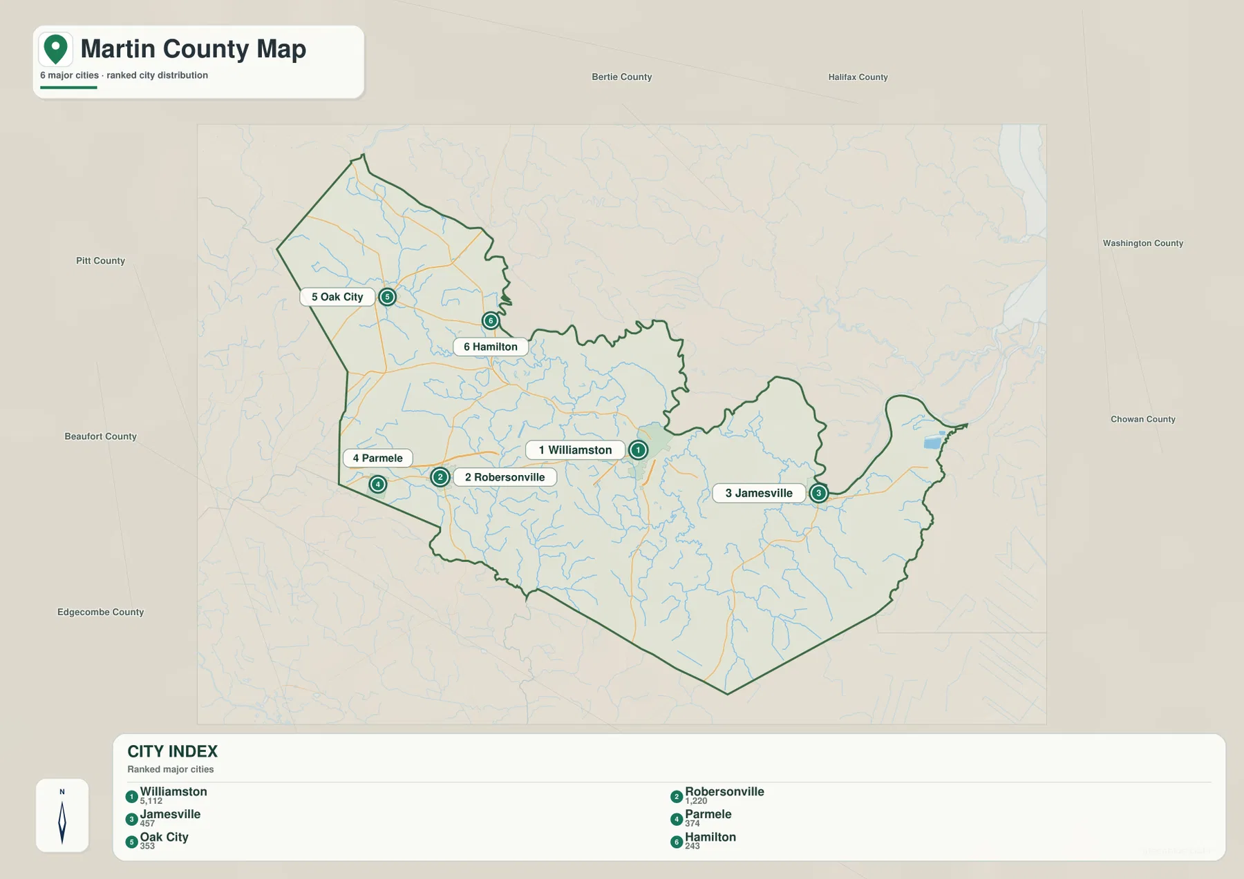
On the county map, Williamston is the easiest place to use as an initial reference. It sits a little east of the county’s center and is marked with the county government symbol, while several roads approach from different directions. From Williamston, the main east–west route continues west through Everetts toward Robersonville and Parmele, while another stretch continues east toward Jamesville. This position helps explain why Williamston functions well as a geographic anchor even though it is not centered perfectly inside the county outline.
The western road pattern is especially clear around Robersonville. U.S. 13 and U.S. 64 pass through or near the town and connect it with Everetts and Williamston to the east. Parmele lies closer to the western county line, where U.S. 64 and N.C. 11 are shown in the same general area. N.C. 903 heads south from the Robersonville area, while N.C. 42 and N.C. 142 lead north toward Oak City. N.C. 111 appears farther northwest, and these numbered roads provide practical reference points for locating communities that otherwise look isolated on a county outline.
Oak City and Hamilton show why the northern portion of Martin County should not be treated as an extension of the Williamston corridor. Oak City is positioned in the northwest, while Hamilton lies farther east near the northern edge. Between them and the county seat, the map shows many small streams and a boundary that bends sharply instead of following a simple straight line. The shape becomes even more irregular east of Hamilton, where the county edge turns and follows a complicated lowland area before widening again toward the Williamston side.
Jamesville occupies a different part of the county. It lies east of Williamston along the main road through the eastern half, and the county boundary beyond it becomes narrow, curved, and strongly influenced by nearby water. Plymouth is labeled outside the county to the east, providing a useful regional reference without implying that it lies inside Martin County. This eastern projection is one of the most distinctive shapes on the map and is a good reminder that county-level travel and service areas do not always match a simple rectangular grid.
The county map is best used for orientation rather than turn-by-turn navigation. It clearly shows where the named communities sit in relation to the county edge and which major highways connect them, but it is not intended to replace a current road-navigation service. For a visitor trying to understand Martin County before a trip, a student preparing a regional map, or a reader comparing nearby counties, the combination of town labels and numbered highways gives enough detail to establish direction without overwhelming the page with every local street.
Six ranked settlements show a county with several separate rural centers
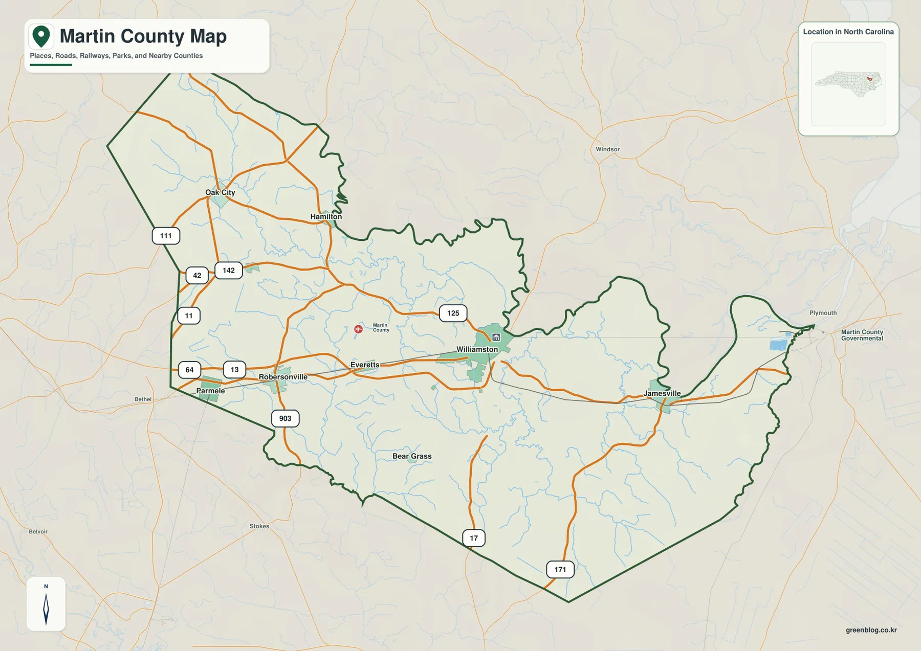
The city-distribution map ranks Williamston first, Robersonville second, Jamesville third, Parmele fourth, Oak City fifth, and Hamilton sixth. The ranking is useful, but the spatial arrangement is even more informative. Williamston and Jamesville occupy the eastern half of the county, Robersonville and Parmele form a western pair, and Oak City and Hamilton sit well to the north. That layout makes it immediately clear that Martin County is not organized around a single dense cluster of communities.
Robersonville and Parmele are the most obvious western references. They appear relatively close to one another on the map, yet they occupy different positions along the road network: Robersonville is tied to the U.S. 13 and U.S. 64 corridor, while Parmele sits nearer the county line. Oak City is farther north and does not simply continue the same west–east line. A reader looking only at a town list might assume that these places form one compact group, but the map shows a broader spread across the western and northwestern portions of the county.
Hamilton adds another northern reference. It is east of Oak City and close to the irregular upper boundary, where numerous watercourses cut across the lowland landscape. Its position helps separate the idea of “north Martin County” from the western U.S. 64 corridor. In practical terms, someone comparing Oak City, Hamilton, and Williamston should expect to move through a network of rural roads rather than between adjacent neighborhoods. The distribution map is useful precisely because it strips away some road detail and makes these larger separations easy to see.
Williamston and Jamesville define the eastern side in a different way. Williamston is the administrative center and the highest-ranked settlement on the city index, while Jamesville lies farther east along the road crossing the county. The terrain-and-water map shows that this eastern side is also where the county outline becomes closely associated with larger waterways and wet lowlands. Seeing the two towns in relation to that natural setting helps explain why the east is not merely a continuation of the agricultural interior.
This map should not be read as a road-distance diagram. Its purpose is to compare settlement importance and position, not to show driving time or the exact mileage between towns. For trip planning, the county road map should be used with a current navigation source. For a geographic overview, however, the ranked distribution makes an important point very efficiently: Martin County’s named centers are spread across several directions, and Williamston’s role as county seat does not mean that all other communities are clustered immediately around it.
Creeks, swamps, and lowland water shape the county more than relief does
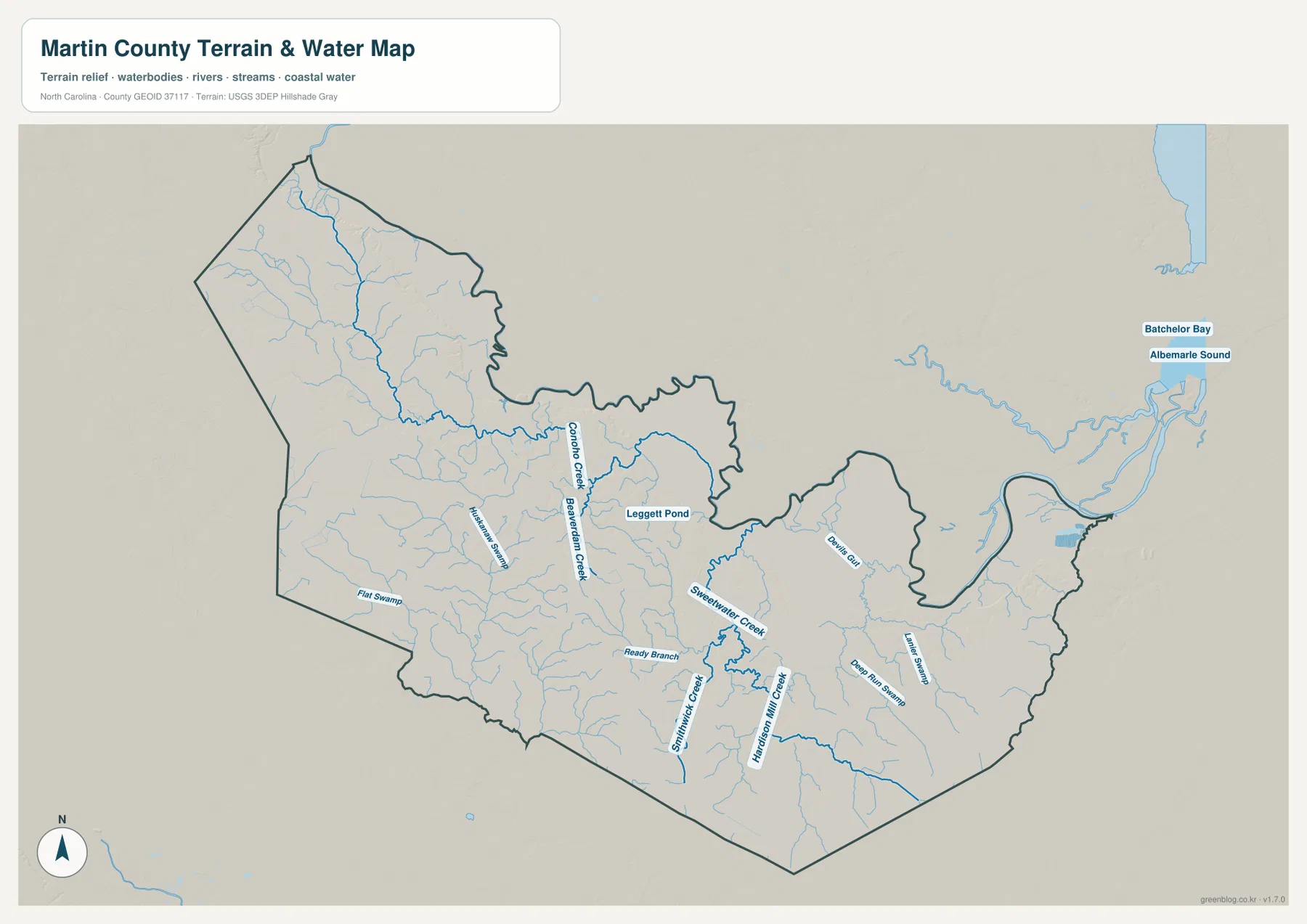
The terrain and water map changes the character of Martin County immediately. Instead of the orange road network, the eye is drawn to a dense web of blue streams spreading across a mostly subdued relief surface. Conoho Creek is one of the strongest named features in the northern and central part of the county. Beaverdam Creek runs nearby, and smaller tributaries branch toward them from several directions. The pattern is typical of a low Coastal Plain county where water can spread through broad, shallow drainage systems rather than being confined to steep mountain valleys.
Sweetwater Creek becomes prominent farther south and east of the central area. Smithwick Creek and Higgins Mill Creek form long north–south or northwest–southeast water lines in the southern half, while Ready Branch and several smaller tributaries connect into the same broader drainage network. These names are useful because they provide real local reference points within a landscape that otherwise looks relatively uniform on a relief map. A road may cross many small branches in a short distance even when the surrounding land appears flat.
Several named features use the word “Swamp,” including Flat Swamp, Honeypot Swamp, Deep Run Swamp, and Lewis Swamp. Their appearance on the map does not by itself establish legal wetland boundaries or flood status for a particular parcel, but it does show that wet lowland drainage is an important part of the county’s natural setting. The same caution applies to the many small streams drawn across the map: this is a county-scale reference image, not a parcel survey, flood-insurance map, or engineering hydrography product.
Leggett Pond is labeled near the center-north, adding a small standing-water reference among the creeks. To the east, larger water features lie close to the county’s most irregular boundary. Albemarle Sound and Batchelor Bay are labeled outside the county as regional reference points, helping place the local drainage network within the broader eastern North Carolina water system. Those labels should not be interpreted as meaning that Martin County has a long sound shoreline; rather, they show the direction in which the larger waterways and lowlands continue beyond the county.
The terrain shading is intentionally gentle. There are no dramatic mountain ridges or deep, narrow valleys like those found in western North Carolina counties. Instead, subtle elevation differences combine with streams, swamps, and low areas to create the county’s physical structure. This makes the water map particularly useful in Martin County: where relief alone may look almost featureless, the creek network reveals how the land is divided into many small drainage areas.
Comparing this image with the road map adds another layer of meaning. Robersonville, Williamston, and Jamesville are connected by important roads, but between and around them lie numerous creeks that are easy to overlook on a transportation-focused map. Oak City and Hamilton sit in a northern area where the tributary network is especially visible. The eastern edge near Jamesville and beyond becomes easier to understand when the irregular boundary is viewed alongside larger water channels. For county-level study, this combination of settlement and hydrology is more useful than treating roads and water as unrelated features.
Choosing the clearest map for roads, towns, or water
Use the county map first when the question is administrative location or road orientation. It shows the full boundary, Williamston’s county-government location, the western U.S. 64 and U.S. 13 corridor, routes toward Oak City and Hamilton, and the road continuing east through Jamesville. It also places nearby towns such as Plymouth outside the county so the reader can understand direction without mistaking an external place for a Martin County community. This is the most practical overview when preparing a simple printed county reference.
Use the ranked settlement map when road detail is less important than the distribution of population centers. It makes the separation between Williamston, Robersonville, Jamesville, Parmele, Oak City, and Hamilton easier to see than the busier general map does. The ranking can help a reader identify which names are most useful to recognize before studying smaller communities. Because it is a distribution map rather than a navigation chart, it works well for classroom comparison, regional orientation, or a quick county profile.
Choose the terrain and water map when the natural setting is the main question. Conoho Creek, Beaverdam Creek, Sweetwater Creek, Smithwick Creek, Higgins Mill Creek, and the named swamps explain far more about the county’s lowland surface than strong relief would. The map is useful for understanding where major drainage features lie, but it should not be used to make parcel-level decisions about flooding, wetlands, property boundaries, or construction. Those questions require current official sources designed for the specific purpose.
For a fuller picture, start with the boundary and road map, move to the settlement distribution, and finish with the water network. That sequence connects Williamston and the other towns to the physical landscape instead of leaving them as isolated labels. If you need a larger copy for printing, a presentation, classroom material, or detailed visual reference, the download box below contains the high-resolution A3 JPG versions corresponding to all three maps shown on the page.
Frequently Asked Questions
Which Martin County towns are most useful to recognize on the maps?
Williamston is the county seat and the first-ranked settlement on the city map. Robersonville and Jamesville provide strong western and eastern references, while Parmele, Oak City, and Hamilton help show how widely the county’s smaller centers are distributed. Looking at all six makes it much easier to understand the county than focusing only on Williamston.
What waterways stand out on the Martin County terrain and water map?
Conoho Creek, Beaverdam Creek, Sweetwater Creek, Smithwick Creek, and Higgins Mill Creek are among the clearest named waterways. The map also labels Flat Swamp, Honeypot Swamp, Deep Run Swamp, Lewis Swamp, Ready Branch, and Leggett Pond. Together they show how strongly lowland drainage shapes Martin County even though the terrain itself has relatively little dramatic relief.
Sources and Reference Material
Map File Information
The ZIP contains the high-resolution A3 JPG versions of the Martin County boundary-and-road map, ranked settlement map, and terrain-and-water map shown on this page.
- Included Files: Use only the versions confirmed in the article and supplied images
- File Type: Use the confirmed download contents
- Intended Use: Printing, education, presentations, and map-based projects
Related Maps
Green Map creates custom-edited map images using open geographic data sources such as geoBoundaries, Natural Earth, OpenStreetMap, and government open data.
These maps are edited visual materials, not raw data files, and are provided for education, documents, presentations, and graphic reference.