This page provides four high-resolution A3 JPG maps of Stephens County in one ZIP download: a county and road map, a city-connections map, a terrain-and-water map, and an elevation map. Together they show why Toccoa functions as the main geographic reference point while the county stretches from higher ridges in the west and northwest toward the Savannah River and Hartwell Lake on the east.
A road-only view makes Toccoa and the numbered highways easy to find, but it does not fully explain the county. The water map adds Toccoa Creek, Rock Creek, Eastanollee Creek, the North Fork Broad River, and numerous lakes. The elevation surface then shows a pronounced west-to-east contrast, with the roughest and highest ground along the western side and lower valleys toward the major eastern waterways. Reading the four maps together gives a more useful picture of how settlements, roads, streams, and relief fit into the same county.
Table of Contents
Toccoa, major roads, and the shape of Stephens County
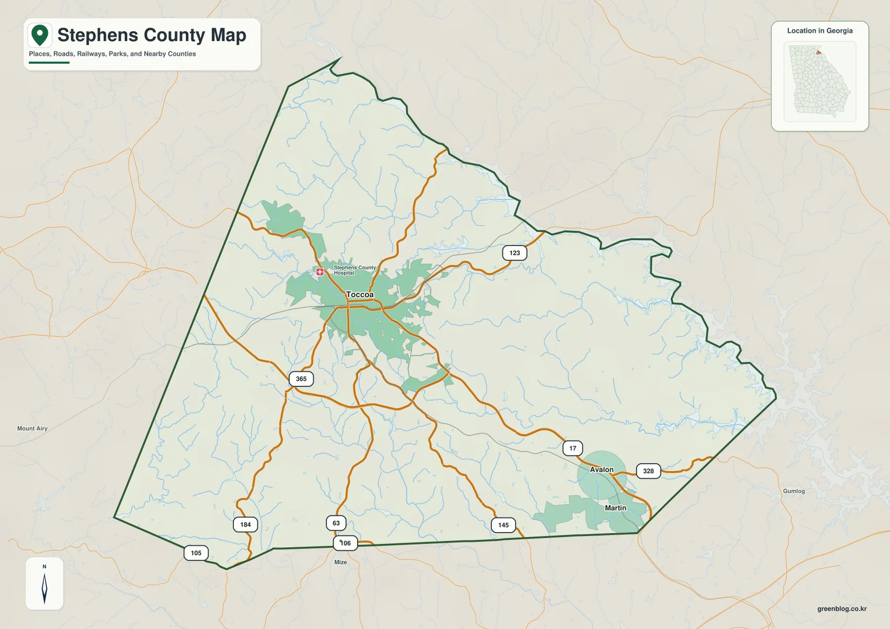
Toccoa is the clearest hub on the county map. State Route 17 and Route 123 extend east and southeast from the city, while Route 365 gives Toccoa a strong connection toward the southwest. Farther south, Routes 184, 63, 106, and 105 reach different parts of the county boundary. Near the southeastern corner, Routes 145 and 328 serve the area around Avalon and Martin. Using Toccoa as the starting point makes the road pattern easier to understand than reading the route numbers as a list.
The county outline is irregular, especially along the east where river and reservoir shorelines create a more complex edge. The northern end narrows into a pointed extension, while the southern boundary runs for a longer distance across the map. Neighboring labels such as Habersham, Franklin, Banks, and Hart counties help place Stephens County within northeast Georgia without confusing those surrounding areas with places inside the county.
City connections from Toccoa to Martin and Avalon
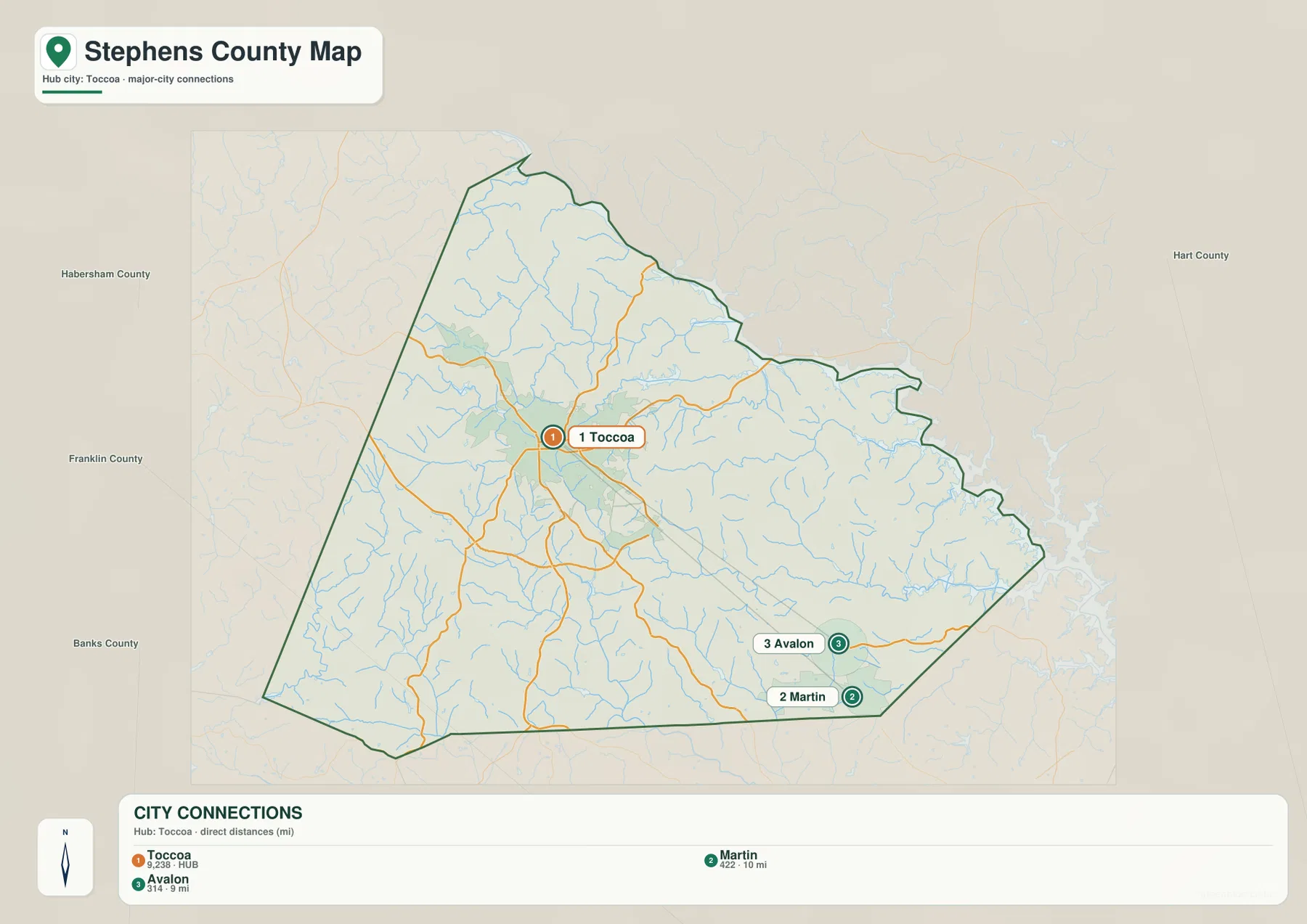
The city-connections map emphasizes the difference between the county hub and its smaller incorporated places. Toccoa is labeled with a population of 9,238. Martin is shown at 422 residents and Avalon at 314. Both lie southeast of the hub rather than forming a continuous urban strip with Toccoa, so the connector lines are useful for showing separation as well as direction.
The distances on this map are straight-line distances, not road mileage. Martin is about 10 miles from Toccoa by the connector measurement, while Avalon is about 9 miles away. Actual driving distance depends on the road used and the exact start and end points. This distinction matters because the route network bends around terrain and waterways, while the city map is designed to give a quick geographic comparison rather than turn-by-turn travel information.
Savannah River, Hartwell Lake, and the county creek network
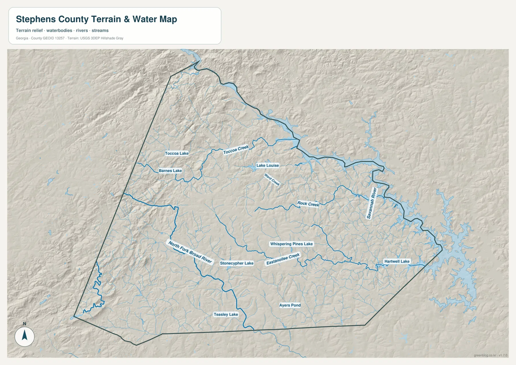
Water is most conspicuous along the eastern side of Stephens County. The Savannah River follows part of that edge, and the branching shoreline of Hartwell Lake reaches into the southeast. Inside the county, Toccoa Creek and Rock Creek drain toward the east, while Eastanollee Creek crosses the southern interior. The North Fork Broad River is a major feature in the southwest and gathers water from a different set of tributaries.
Smaller lakes and ponds are scattered between those larger channels. Toccoa Lake and Barnes Lake sit northwest of the main city area, Lake Louise is farther north and east, and Stonecypher Lake and Whispering Pines Lake appear in the central-southern part of the county. Teasley Lake and Ayers Pond are closer to the southern edge. These features make the terrain map useful for seeing drainage patterns that are easy to miss on a road map. It should not be treated as a flood-risk map, parcel map, or navigation chart.
Higher western ridges and lower eastern valleys
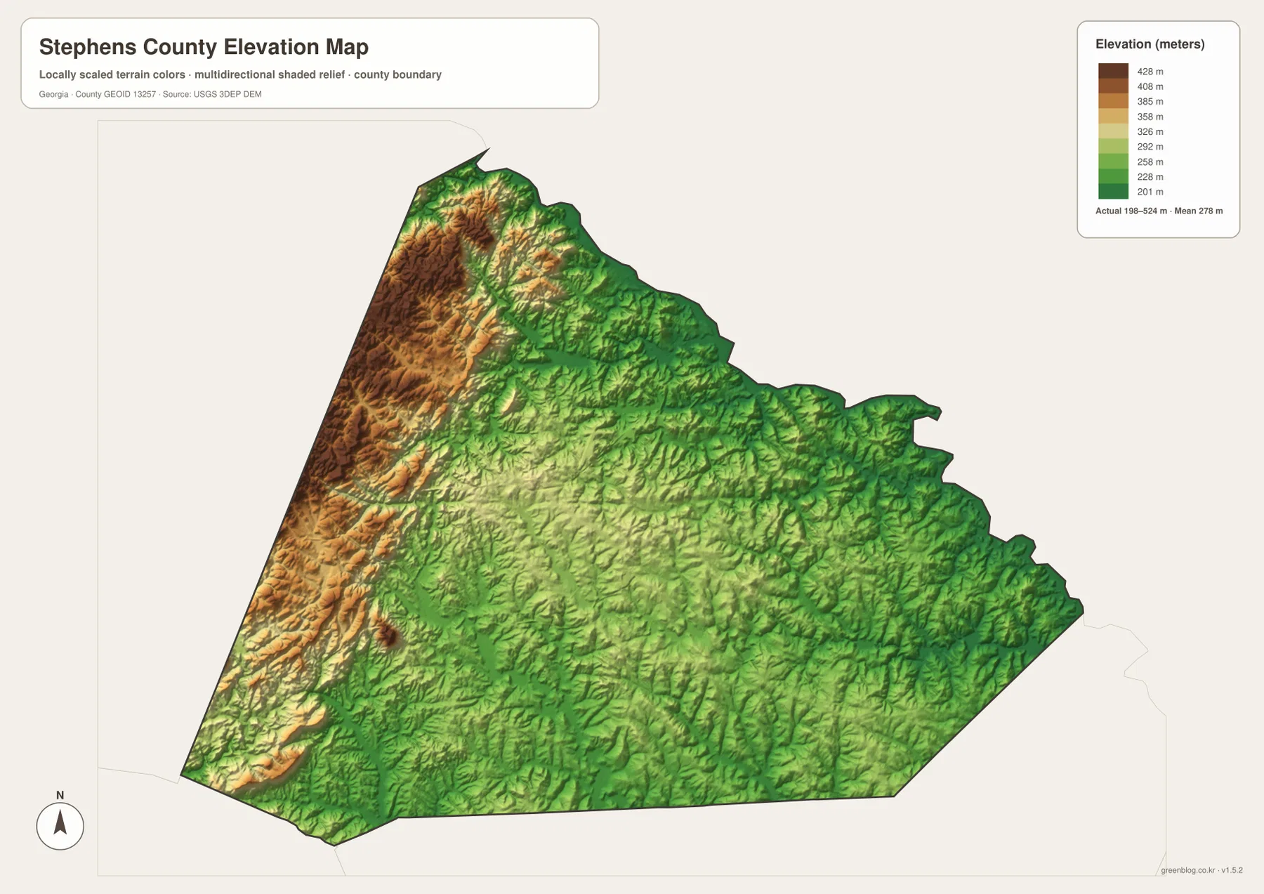
The elevation map shows a clear contrast across a relatively small county. Actual elevations on the map range from about 198 to 524 meters, with a mean near 278 meters. The highest and roughest terrain is concentrated along the west and northwest, where long ridges appear in brown and tan tones. Moving toward the center and east, the colors become progressively greener as the landscape drops into lower rolling ground and stream valleys.
This relief pattern helps explain the water map. Short streams descend from the higher ridges, join larger creeks in lower corridors, and ultimately connect with the larger drainage system toward the Savannah River and Hartwell Lake. Toccoa occupies intermediate rolling terrain between the highest western ridge belt and the lower eastern waters. The elevation surface is appropriate for county-scale comparison, but it is not survey-grade data for engineering, construction, or precise property elevation decisions.
How the four Stephens County maps work together
For a first look at the county, start with the boundary and road map to locate Toccoa and the main numbered routes. Use the city map next if you need to compare the hub with Martin and Avalon. The water map becomes more useful when the question shifts to creeks, lakes, and the eastern reservoir edge, and the elevation map explains why those channels follow particular valleys and why the western side looks more rugged.
That sequence works well for school projects, local orientation, printed reference sheets, or regional research. The road and city maps answer location questions quickly, while the water and elevation views add physical context. None of the four maps is intended to replace a parcel survey, flood determination, engineering elevation model, or navigation product; they are county-scale reference maps designed to be read together.
Frequently Asked Questions
Are the distances from Toccoa to Martin and Avalon road miles?
No. The 10-mile and 9-mile values on the city-connections map are straight-line distances from the Toccoa hub. Driving distance can be longer because roads do not follow a perfectly direct line.
Can the water map be used to identify flood-risk areas?
No. It is a reference map for the location of rivers, creeks, lakes, and terrain. Flood-risk decisions require the appropriate official flood-hazard mapping.
Is the elevation map precise enough for surveying or construction?
No. It is a generalized county-scale elevation surface meant to compare high ridges and lower valleys. Site-specific engineering or property work requires more precise survey data.
Sources and reference data
The following official resources provide county background and authoritative reference data for boundaries, waterways, and elevation.
- Official Stephens County overview
- U.S. Census Bureau QuickFacts
- USGS National Hydrography
- USGS 3D Elevation Program
Map File Information
The ZIP contains four original high-resolution JPG maps: county and roads, city connections, terrain and water, and elevation.
- Included Files: 4 original high-resolution JPG maps: county and roads, city connections, terrain and water, and elevation
- File Type: JPG files in a ZIP archive
- Intended Use: Printing, education, presentations, and map-based projects
Related Maps
Green Map creates custom-edited map images using open geographic data sources such as geoBoundaries, Natural Earth, OpenStreetMap, and government open data. These maps are edited visual materials, not raw data files, and are provided for education, documents, presentations, and graphic reference.