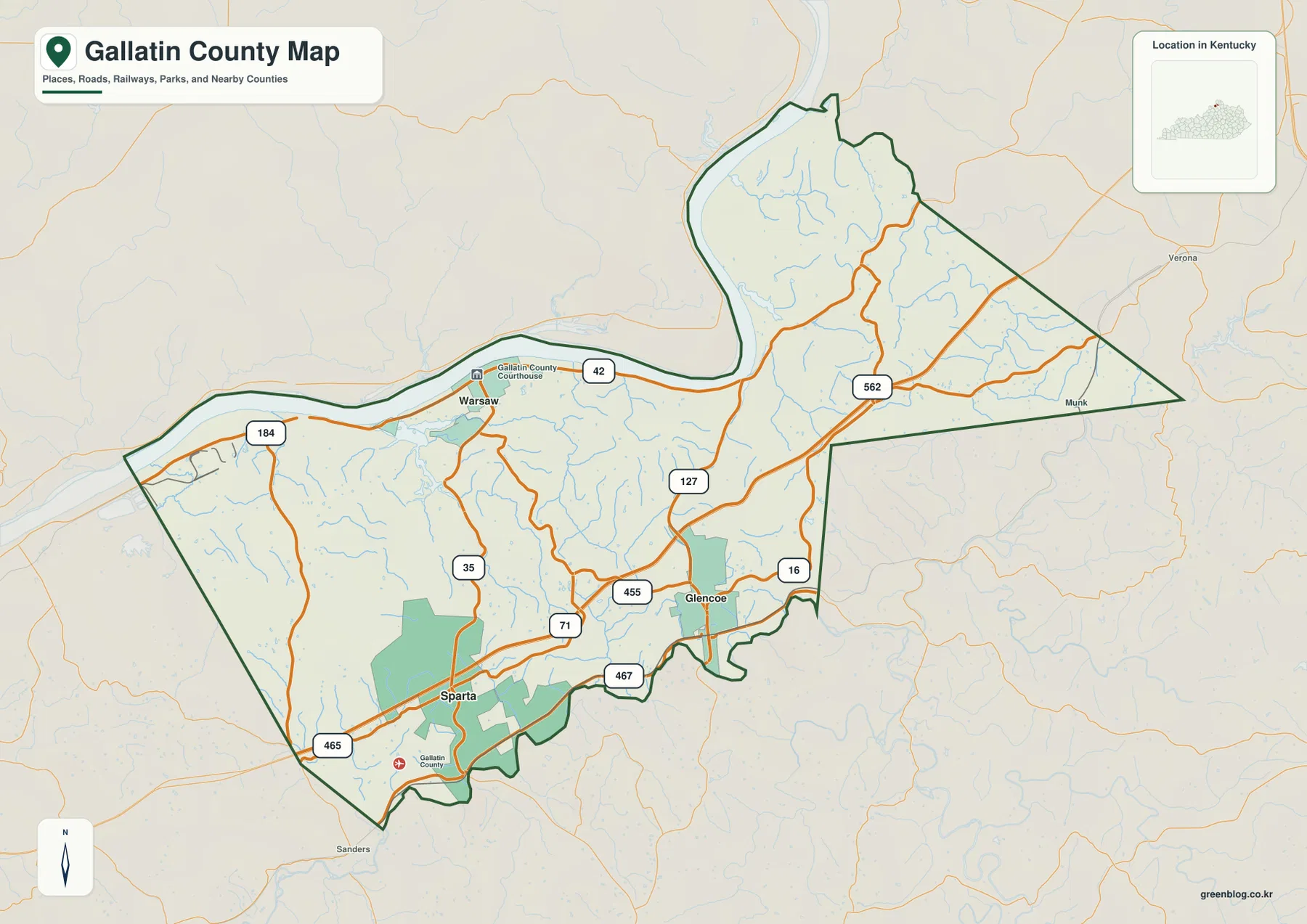
Gallatin County sits along a broad bend of the Ohio River in northern Kentucky, with Warsaw on the river and Glencoe and Sparta farther south near the I-71 corridor. The maps on this page show county boundaries, roads, the three main city labels, creeks, and terrain from about 131 to 282 meters. High-resolution JPG versions of all four maps are also available in the ZIP download below.
The easiest way to understand the county is to start with the Ohio River. It forms a long western and northwestern edge, bends sharply north of Warsaw, and helps explain the county’s unusual outline. South of the river town, the map becomes more road-oriented: I-71, state routes, and the small centers of Glencoe and Sparta provide clearer reference points than the river itself.
Table of Contents
Warsaw sits where the Ohio River defines the county’s northern edge
Warsaw is the most prominent place on the general county map. The built-up area lies directly south of the Ohio River, and the Gallatin County Courthouse is labeled near the city center. U.S. 42 follows the river corridor through Warsaw and continues east and west, making it the clearest road reference for the riverfront part of the county.
The county boundary changes character around the river. The western section stretches along the Ohio, the northern tip follows a large river bend, and the eastern side narrows into a pointed wedge before turning south. That shape is useful when matching local roads with neighboring areas. On the city-connections map, Carroll County, Owen County, Boone County, and Grant County are labeled around the county outline, adding regional context without requiring a separate statewide map.
I-71 separates the southern town corridor from the riverfront
The road pattern makes the difference between northern Warsaw and the southern part of Gallatin County easy to see. I-71 cuts diagonally through the south near Sparta and Glencoe, while U.S. 42 serves the Ohio River side around Warsaw. KY 35 runs inland from Warsaw, and U.S. 127 and KY 562 provide additional references through the central and eastern parts of the county. KY 455, 467, 465, and 16 fill in shorter connections around the southern communities.
Sparta lies near the southwestern county edge, with Glencoe farther east. Both are much closer to the I-71 corridor than Warsaw is, so the county can be pictured as two linked settings: a river town in the northwest and a highway-oriented southern area. This distinction is useful when reading a small-scale map because a single compass direction does not fully explain how the communities relate to the main transportation routes.
The city map puts Glencoe and Sparta about six straight-line miles from Warsaw
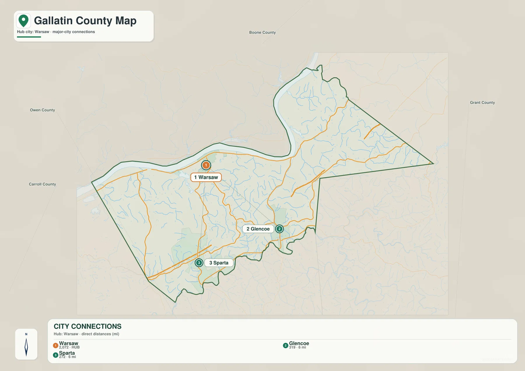
The simplified city-connections map uses Warsaw as the hub and labels Glencoe and Sparta as the other principal city points. Both connections are shown as roughly 6 miles from Warsaw. Those are straight-line distances between mapped points, not driving mileage, so an actual road trip can be longer depending on the route, river crossings, and local access streets.
Removing many smaller labels makes the three-place arrangement especially easy to read. Warsaw occupies the northwestern riverfront, Glencoe sits in the south-central to southeastern part of the county, and Sparta is southwest of Glencoe near the county line. Neighboring county names remain outside the outline, so the map works well when the goal is to explain the relative position of the communities without the detail of every road and creek.
Ohio River lowlands give way to a web of small creek valleys
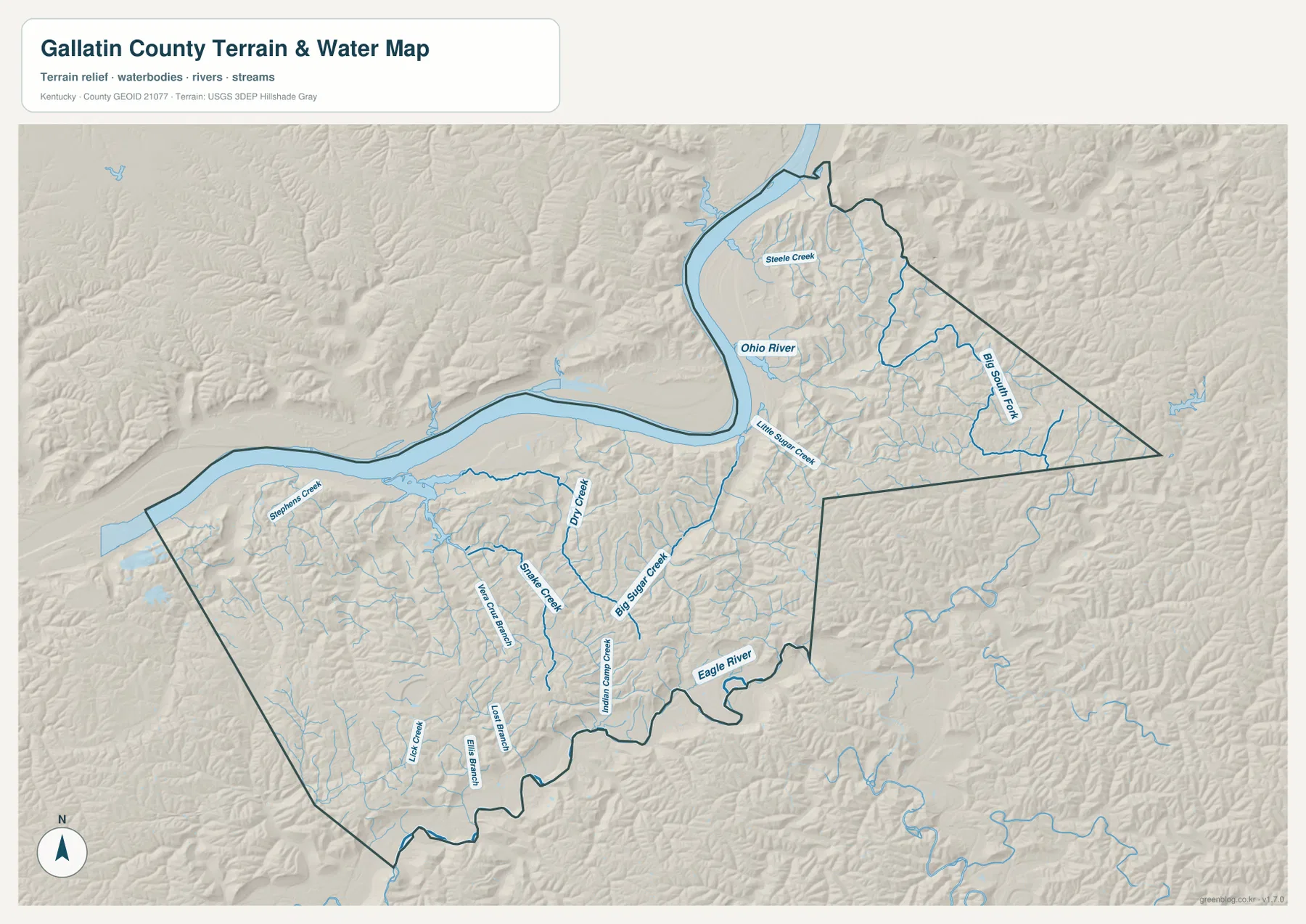
The terrain-and-water map is dominated by the Ohio River. It forms the broad western and northwestern water corridor and creates the large bend above Warsaw. Inland, smaller streams divide the rolling terrain into many short valleys. Big Sugar Creek and Little Sugar Creek are among the clearest named waterways, while Dry Creek, Steele Creek, Snake Creek, Stephens Creek, and Indian Camp Creek add useful local reference points.
Big Sugar Creek runs through the central part of the county toward the Ohio River system, and Little Sugar Creek is visible nearer the northern river bend. Dry Creek and Snake Creek help distinguish the western interior, while Steele Creek occupies part of the northern section inside the bend. These streams help explain why many secondary roads curve rather than forming a regular grid: roads often follow or cross the same narrow valleys cut by the drainage network.
Gallatin County’s official website describes the county as being nestled along the Ohio River in northern Kentucky, which matches the strongest feature on the supplied maps. The water layer is a static geographic reference, however. It should not be treated as a flood-risk map, a source of live river stages, a boating chart, or a legal boundary product.
A 131–282 m elevation range shows how quickly the land rises from the river
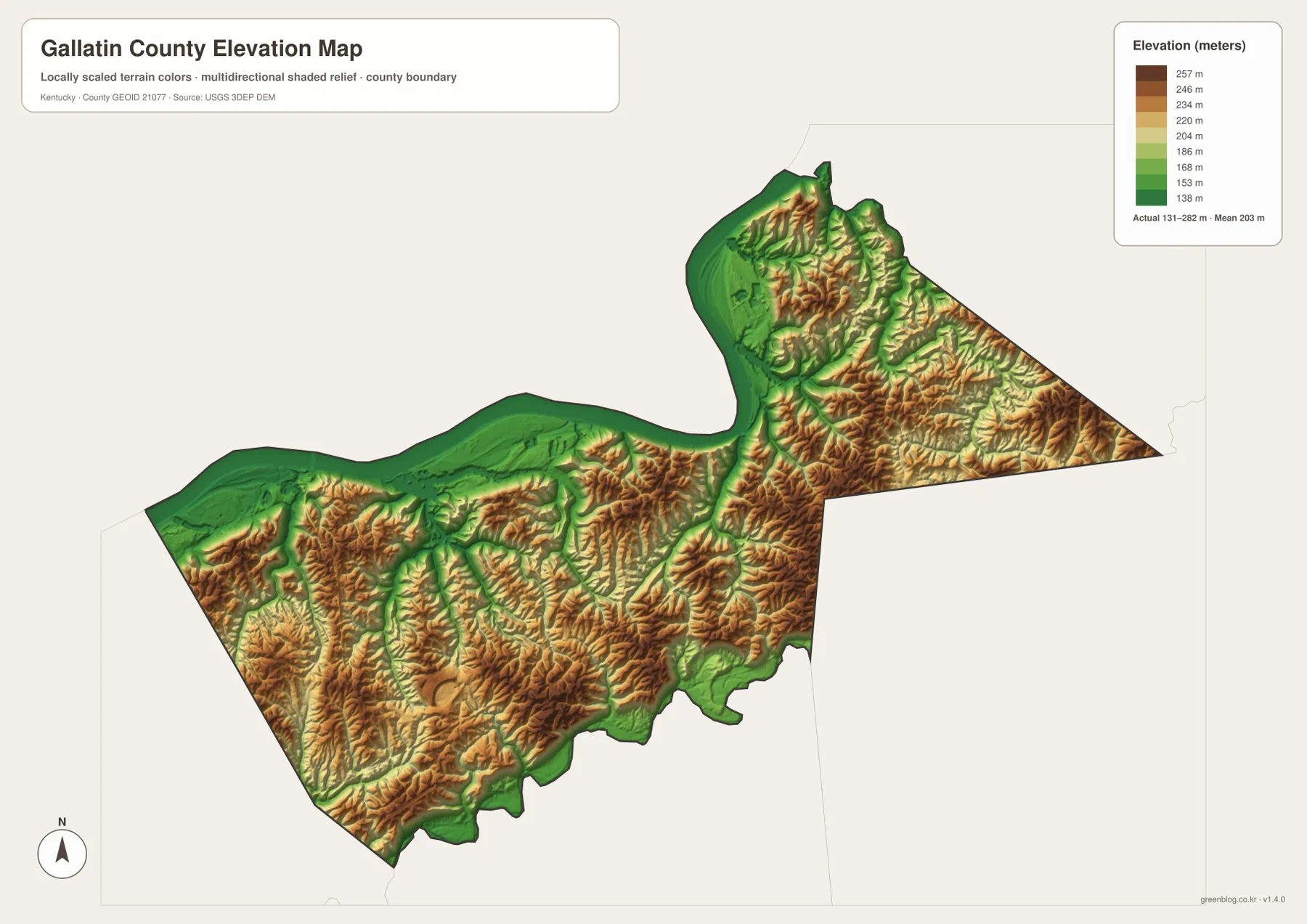
The elevation map reports an actual range of about 131 to 282 meters, with a mean of 203 meters. The lowest green colors are concentrated along the Ohio River, including the Warsaw riverfront and the large bend farther north. Narrow green corridors also extend inland along creek valleys, showing how drainage lines occupy lower ground between the surrounding hills.
Higher yellow, tan, and brown terrain becomes much more common away from the river. The southern and eastern parts of the county contain closely spaced ridges, and the pointed eastern section has a particularly dense pattern of short valleys and higher crests. The southwestern interior also rises quickly once the broad Ohio River lowland is left behind. Gallatin County is not a high mountain county, but the relief is strong enough to create a clear river-to-ridge contrast across a relatively small area.
The elevation colors are generalized for county-scale comparison. They are useful for seeing the difference between river bottoms, creek valleys, and surrounding ridges, but they should not be used as survey-grade or engineering elevations for a specific property. For map reading, the layer works especially well beside the water map because many of the green low corridors line up with named creeks.
Pair the river map with the road map for practical orientation
For Warsaw and the northwestern part of the county, the general map and water map make the most useful pair. U.S. 42 and the Ohio River provide two nearly parallel references around the riverfront, and the river’s large bend makes it easy to distinguish Warsaw from the northern wedge. Smaller inland locations become easier to place when a creek name from the water map is matched with a numbered road from the general map.
For Glencoe and Sparta, the city-connections map and general road map are a better combination. The simplified city layer shows how the three main places relate to one another, while the general map adds I-71 and the surrounding state routes. Adding the elevation map explains why those routes are not simply drawn across a flat surface: the southern interior alternates between narrow lower corridors and rolling ridges.
Choose the Gallatin County file by the question you need to answer
Use the general county map when you need roads, boundaries, city labels, and nearby context on one page. Choose the city-connections map when the main task is comparing Warsaw, Glencoe, and Sparta without extra detail. The terrain-and-water map is better for the Ohio River and named creeks, while the elevation map is the clearest option for comparing the river lowland with the higher ridges inland.
The high-resolution JPG originals are packaged below for printing, classroom material, local orientation, and personal reference. Because the four files show the same county from different angles, using two maps side by side often gives more context than relying on a single layer.
Frequently Asked Questions
Where is Warsaw on the Gallatin County map?
Warsaw is in the northwestern part of the county directly south of the Ohio River. U.S. 42 passes through the city, and the Gallatin County Courthouse is also labeled there. The large river bend immediately north of Warsaw makes the city easy to locate even on the terrain and elevation maps.
Are the 6-mile Warsaw-to-Glencoe and Warsaw-to-Sparta measurements driving distances?
No. The city-connections map uses straight-line distance between the mapped city points. Actual driving mileage can be longer because roads must follow the local network and the county’s rolling terrain. Use a current navigation or road service when you need a live driving route.
What part of Gallatin County is lowest on the elevation map?
The lowest colors follow the Ohio River and its broad lowland, including the Warsaw riverfront. The map reports an actual county range of about 131 to 282 meters and a mean of 203 meters. Higher terrain becomes more common across the southern and eastern interior.
Map File Information
Download high-resolution JPG originals for Gallatin County's general, city-connections, terrain-and-water, and elevation maps in one ZIP file.
- Included Files: county map, city map, terrain-and-water map, elevation map
Related Maps
Sources and references
County information is available from the official Gallatin County website, and local riverfront context is available from the City of Warsaw. State highway and printable road references can be checked through the Kentucky Transportation Cabinet.
Administrative boundaries are supported by the U.S. Census Bureau TIGER/Line program. Hydrography references come from USGS National Hydrography, and elevation references come from the USGS 3D Elevation Program. These maps are static references; legal boundaries, parcels, flood risk, live road conditions, and engineering work require current data from the responsible agency.
Green Map creates custom-edited map images using open geographic data sources such as geoBoundaries, Natural Earth, OpenStreetMap, and government open data. These maps are edited visual materials, not raw data files, and are provided for education, documents, presentations, and graphic reference.