Cecil County occupies Maryland’s northeastern corner between Pennsylvania, Delaware, the Susquehanna side of the upper Chesapeake, and the river systems that open toward Chesapeake Bay. Elkton is the county seat, while Rising Sun, North East, Perryville, Port Deposit, Chesapeake City, and Cecilton spread across very different parts of the county. The maps on this page show that contrast through roads, ranked settlements, waterways, and elevation. Matching high-resolution JPG files can also be downloaded together in a ZIP archive. High-resolution map files are available for download in the section below.
Cecil County Government identifies eight incorporated towns: Cecilton, Charlestown, Chesapeake City, Elkton, North East, Perryville, Port Deposit, and Rising Sun. Their geography is unusually varied for one county. The I-95 and U.S. 40 corridor crosses the north-central section, while long peninsulas and tidal rivers shape the south. The county’s western edge meets the Susquehanna and Chesapeake waters, and the eastern side follows the Delaware line for long stretches.
Table of Contents
Elkton and the I-95–U.S. 40 corridor organize the north-central county
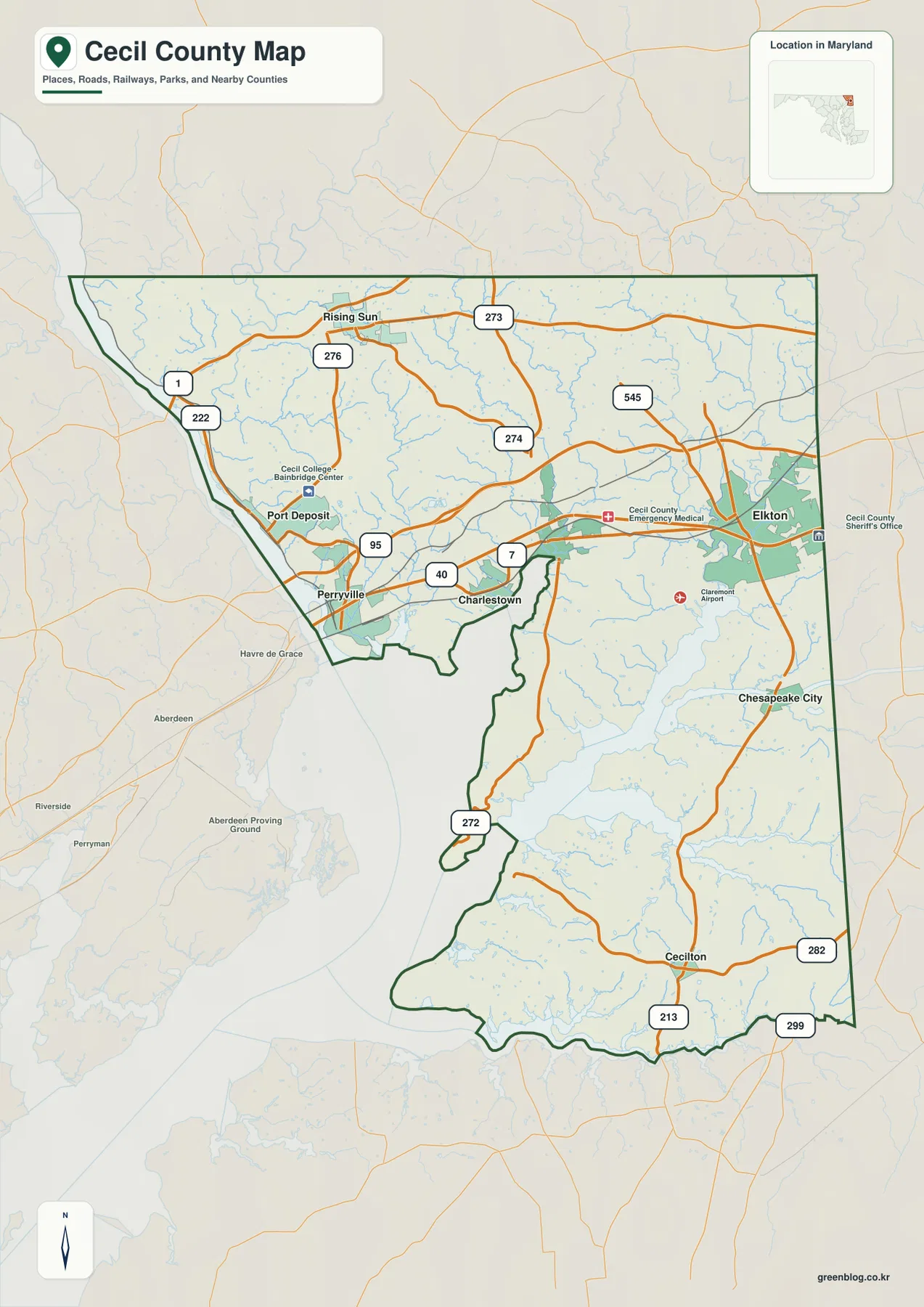
Elkton is the strongest place to begin on the general county map. It sits in the eastern part of the north-central corridor, with North East, Charlestown, and Perryville extending westward. Rising Sun is farther north and northwest. I-95 and U.S. 40 provide two major east-west references, so locating those routes first makes the settlement pattern much easier to understand.
Perryville and Port Deposit occupy the western side close to broad Chesapeake and Susquehanna waters. U.S. 40 passes through the Perryville side and continues toward Charlestown, North East, and Elkton, while MD 7 offers another road reference through the same general corridor. U.S. 222 turns north from the Port Deposit area and helps connect the western edge with the Rising Sun side of the county.
Around Rising Sun, MD 273 and MD 276 are easy to identify. MD 273 runs broadly east-west, while MD 276 heads south toward the U.S. 1 and U.S. 222 area. MD 274 appears farther east through the upper middle of the county, and MD 545 provides another north-south reference above Elkton. Instead of memorizing every route number, readers can use Elkton, Rising Sun, and Perryville as anchors and add the nearest state road as needed.
The map also labels Cecil College’s Bainbridge Center, Cecil County Emergency Medical facilities, and Claremont Airport, which can help with local orientation. It is not a live traffic map, however. Construction, congestion, closures, and travel time on I-95, U.S. 40, and the state routes should be checked with current Maryland transportation information and a navigation service.
South of the main highway corridor, roads follow a landscape divided by rivers and peninsulas
The county changes quickly south of Charlestown and North East. MD 272 continues down the Elk Neck side, while MD 213 becomes one of the clearest road references around Chesapeake City and farther south. MD 282 and MD 299 help organize the Cecilton area. This southern road pattern is less dominated by the interstate corridor and more strongly influenced by rivers, estuaries, and long peninsulas.
Chesapeake City sits between large tidal systems associated with the Elk and Bohemia rivers. Cecilton is farther south in a flatter part of the county near MD 213, MD 282, and MD 299. Both places belong to the southern half of Cecil County, but the surrounding water and road layout give them very different settings on the map.
The western county boundary bends around the broad waters near Perryville and Port Deposit, then the outline becomes increasingly complicated around Elk Neck and the upper Chesapeake. By contrast, the Delaware-facing eastern side includes much straighter boundary segments. The water map explains these differences better than the road layer alone because the rivers and bays that shape the southern county are shown much more clearly.
Water also means that short map distances do not always translate into short road trips. Chesapeake City, Cecilton, and the Elk Neck area may require routes that work around rivers or use specific crossings. The maps here are intended for geographic orientation; current routing software is the appropriate tool for exact driving mileage and travel time.
The City Index spreads six ranked places from Rising Sun to Cecilton
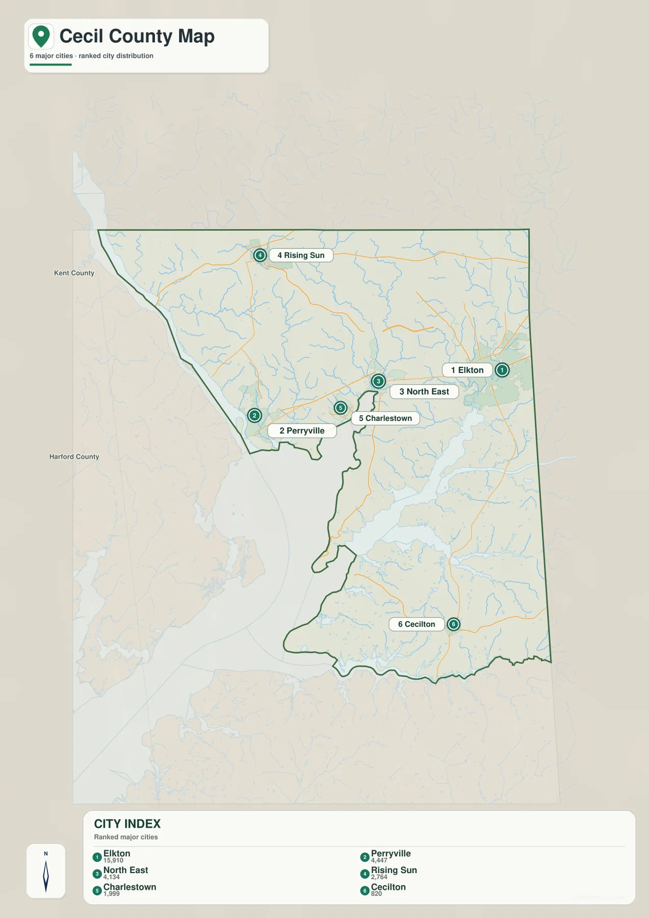
The City Index ranks Elkton, Perryville, North East, Rising Sun, Charlestown, and Cecilton. It prints the values 15,910 for Elkton, 4,447 for Perryville, 4,134 for North East, 2,764 for Rising Sun, 1,999 for Charlestown, and 820 for Cecilton. The graphic does not identify a reference year or statistical definition, so those figures should not be presented as current population counts. Current demographic information should come from the latest U.S. Census Bureau data.
The positions of the markers are more useful than the ranking itself. Elkton is in the eastern north-central county, Perryville is near the western waterfront, and North East and Charlestown sit between them. Rising Sun is separated well to the north, while Cecilton lies far to the south. Even with only six points, the graphic shows that Cecil County’s major settlements are spread across several distinct regions.
Port Deposit and Chesapeake City appear on the general map but are not among the six ranked locations. Cecil County Government still lists both as incorporated towns. The City Index should therefore be treated as a simplified selection of major settlements rather than a complete municipal directory.
There are no connector lines or mileage values between the city markers. The graphic cannot be used to estimate road distance from Elkton to Perryville, Rising Sun, or Cecilton. It works best for quick settlement distribution, with the full county map and current routing tools used when roads and travel are the main concern.
Elk River, Bohemia River, and Sassafras River carve the southern county into peninsulas
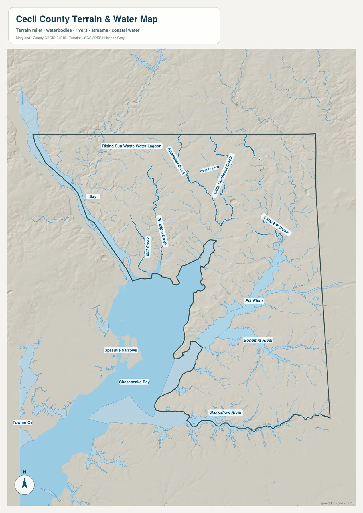
The water map makes the southern shape of Cecil County much easier to understand. Elk River occupies the central-eastern tidal area and opens toward Chesapeake Bay, while Bohemia River lies farther south. Sassafras River follows the southern edge. Land between these broad river systems forms long peninsulas, so the county’s lower half has a much more intricate shoreline than its northern boundary.
Elk Neck is the clearest example. Maryland DNR describes Elk Neck State Park as occupying a peninsula between Chesapeake Bay on the west and Elk River on the east. On the county map, MD 272 leads south from the North East area along this peninsula. Turkey Point at the southern end provides a real-world reference for how close the two major bodies of water come around the county’s central coastal landform.
The northern water network is smaller but equally important to the terrain. Little Northeast Creek and its West Branch are labeled in the upper middle of the county, while Little Elk Creek appears farther east toward Elkton. Principio Creek and Mill Creek are visible on the western-central side near the Perryville-Charlestown area. These streams help connect the rolling northern uplands with the lower tidal waters to the south.
Spesutie Narrows and Chesapeake Bay are labeled to the west, and the Perryville-Port Deposit side lies close to the Susquehanna River mouth. Cecil County planning material identifies the Susquehanna, Northeast, Elk, Bohemia, and Sassafras as major river systems in the county. This water map is not a nautical chart, flood map, or depth source; boating, tides, flood risk, and navigation require current NOAA, FEMA, USGS, Maryland, or local information.
Elevation rises in the north and northwest, then drops toward the coastal plain
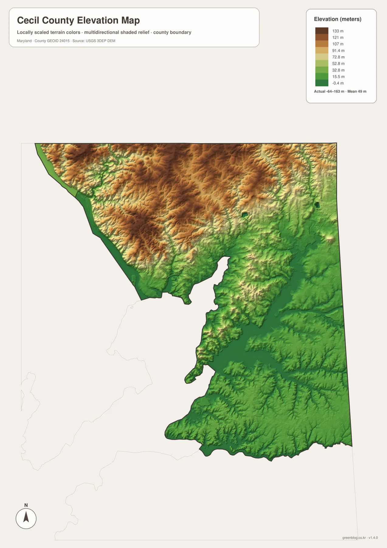
The supplied elevation graphic prints an actual data range of -64 to 163 meters and a mean of 49 meters. Those numbers describe the range in the map’s elevation dataset and should not be treated as parcel-level survey elevations. Visually, the strongest pattern is clear: higher brown and tan terrain covers much of the north and northwest, while lower green land expands around Elkton, the tidal rivers, and the southern county.
Cecil County planning documents describe two major physiographic settings separated near the Fall Line. The northern and northwestern Piedmont contains rolling terrain cut by deeper stream valleys, while the southern and southeastern Atlantic Coastal Plain is generally lower and flatter. The map reflects that transition, with the terrain changing noticeably south of the I-95 and U.S. 40 corridor.
Elk Neck remains somewhat more elevated than the very low surrounding tidal water, producing a narrow ridge-like peninsula between Chesapeake Bay and Elk River. Farther south around Cecilton and the Sassafras side, broad areas are rendered in lower green tones. Comparing the water and elevation layers makes it easier to see how creeks descend from the higher north toward the lower river and bay system.
The elevation image is designed for broad geographic comparison, not engineering or surveying. Exact building, road, and property elevations require authoritative USGS elevation data or professional survey measurements. Flood exposure also cannot be determined from elevation color alone and should be checked with current FEMA and local flood products.
The most useful map depends on whether you need roads, settlements, water, or relief
Use the general county map for Elkton, Rising Sun, Perryville, I-95, U.S. 40, MD 273, and MD 272. Use the City Index when the main goal is to compare the distribution of six ranked settlements without the distraction of smaller roads. The water map is the better choice for Elk River, Bohemia River, Sassafras River, Chesapeake Bay, and the northern creek network, while the elevation map explains the contrast between the higher northern terrain and lower coastal plain.
Elk Neck State Park provides a useful local example of the county’s geography. Maryland DNR describes the park as a peninsula between Chesapeake Bay and Elk River with forests, marshes, cliffs, and shoreline. The county map places the park area south of North East along MD 272, but current park hours, access, and recreation rules should always be checked on the official DNR site before a visit.
The downloadable originals are JPG files measuring 2572 × 3638 pixels each. They work well in full-page documents and can be enlarged around Elkton, Rising Sun, Perryville, or Elk Neck for classroom material, presentations, and personal reference. Enlarging the images does not add live traffic, parcel boundaries, flood zones, nautical depth, or survey-grade elevation, so specialized decisions should always use current official data.
Frequently Asked Questions
What is the county seat of Cecil County, Maryland?
Elkton is the county seat. Cecil County planning material identifies Elkton as the county seat, and the general map places it in the eastern part of the north-central road corridor near I-95 and U.S. 40.
Does the six-place City Index include every incorporated town in Cecil County?
No. The City Index marks Elkton, Perryville, North East, Rising Sun, Charlestown, and Cecilton, while Cecil County Government also lists Port Deposit and Chesapeake City among the county’s eight incorporated towns. The index is therefore a simplified ranked-place view, not a complete municipal list.
Can the -64 to 163 meter elevation range be used as a property survey?
No. It is the range printed on the supplied elevation graphic and is useful only for broad geographic comparison. Property-level elevation should come from authoritative USGS or professional survey data, and flood decisions should rely on current FEMA and local flood information.
Map File Information
The ZIP archive contains high-resolution JPG maps of Cecil County matching the map themes described on this page.
- Included Files: county and major roads map, City Index map, terrain and water map, elevation map
- Printable Size: 2572 × 3638 pixels each
- File Type: JPG
Related Maps
Sources and References
- Cecil County Government – Towns
- Cecil County Comprehensive Plan
- Maryland DNR – Elk Neck State Park
- U.S. Census Bureau – TIGER/Line Shapefiles
- USGS – National Hydrography
- USGS – 3D Elevation Program
Green Map creates custom-edited map images using open geographic data sources such as geoBoundaries, Natural Earth, OpenStreetMap, and government open data. These maps are edited visual materials, not raw data files, and are provided for education, documents, presentations, and graphic reference.