Caldwell Parish sits in northeastern Louisiana, with Columbia near the central Ouachita River corridor and Grayson, Clarks, and Banks Springs extending south through the parish interior. This Caldwell Parish Map collection shows US 165, LA 4, LA 133, the Ouachita River, Castor Creek, Hurricane Creek, and a series of small lakes and cutoff channels along the eastern lowlands. High-resolution map files are available for download in the section below.
The package includes three map themes only: a general parish map, a city-connections map, and a terrain-and-water map. High-resolution JPG versions of all three can be downloaded together in one ZIP. Columbia and Clarks make useful settlement anchors, while the Ouachita River on the east and the more creek-cut western terrain reveal two different sides of the parish.
Table of Contents
Columbia anchors US 165, LA 4, and LA 133 in the middle of the parish
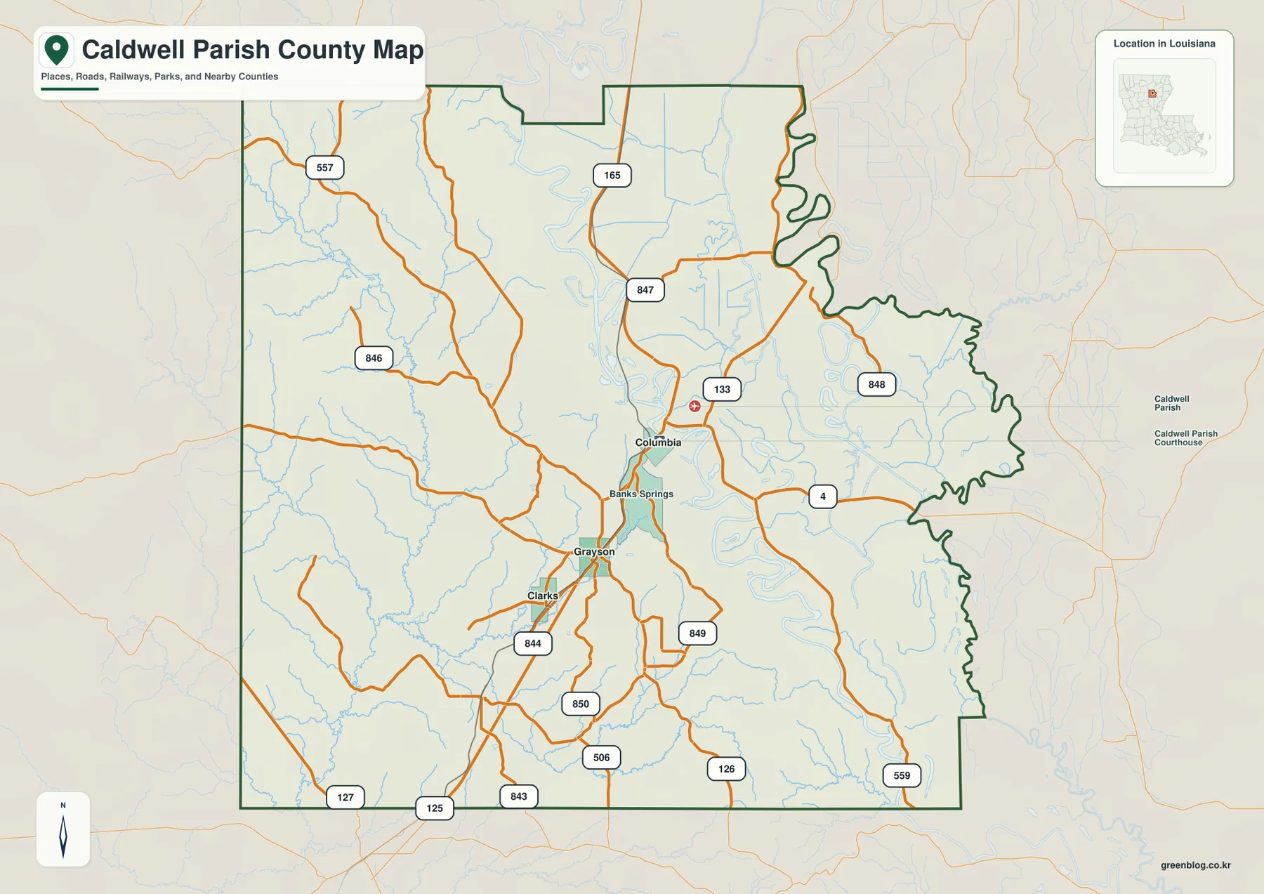
Columbia is the clearest starting point on the general map. US 165 runs north–south through the parish, LA 133 continues south from Columbia toward Grayson and Clarks, and LA 4 heads east toward the Ouachita River side. LA 847 and LA 848 provide additional local references north and east of Columbia.
Banks Springs lies immediately south of Columbia, followed by Grayson and Clarks farther down the central corridor. LA 844 and LA 850 help locate the Clarks area, while LA 126, LA 127, LA 843, and LA 849 organize the southern road network. Settlements are relatively close together in this central strip, but road spacing increases rapidly toward the western and eastern edges.
LA 557 and LA 846 cross the northwestern side, where the map shows fewer towns and a denser network of creeks. The eastern outline is much more irregular because it follows the Ouachita River and associated bends. Even without an elevation map, the base relief and water layer suggest a stronger contrast between the creek-cut west and the lower river side.
Louisiana’s official Caldwell Parish profile identifies Columbia as the parish seat, and the Caldwell Parish Clerk of Court is located at the courthouse there. That administrative role matches Columbia’s central position on the map. The general map is intended for geographic orientation rather than live traffic, construction, speed limits, or private access.
Clarks is the hub for the map’s short city connections
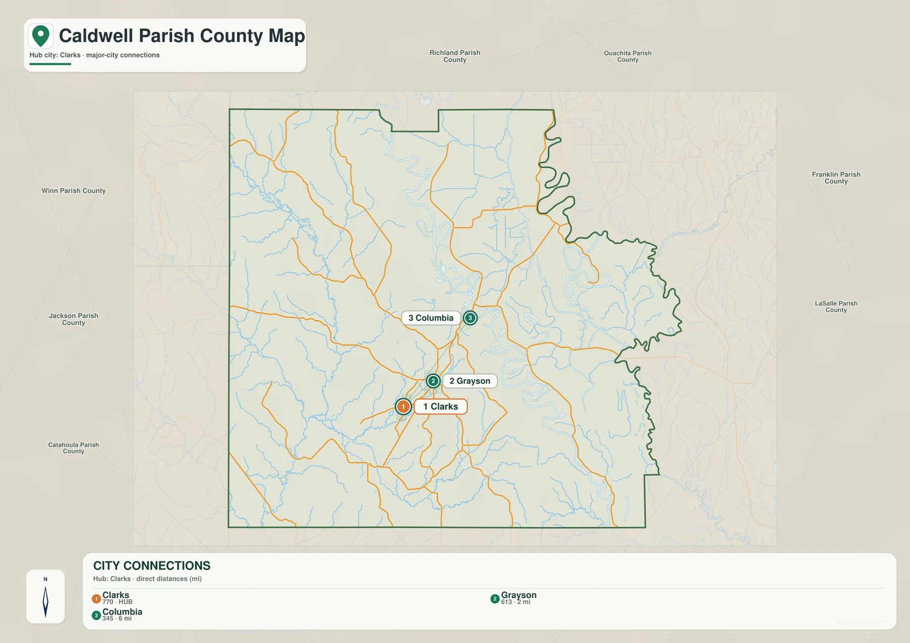
The city-connections map uses Clarks as the hub rather than Columbia. Grayson is shown about 2 miles away in straight-line distance, while Columbia is about 6 miles from Clarks. These are direct distances between the mapped places, not driving distances or travel-time estimates.
Grayson lies just northeast of Clarks, with Columbia farther north along the same central part of the parish. Comparing the city map with the general road map shows why these three places feel closely connected despite the rural setting: US 165 and LA 133 keep them within the same north–south corridor.
Neighboring parish labels add useful regional context. Winn and Jackson Parishes lie to the west, Richland and Ouachita Parishes are north, Franklin and LaSalle Parishes appear east and southeast, and Catahoula Parish lies to the southwest. This places Caldwell Parish south of the Monroe area and north of central Louisiana.
The population figures shown in the city index belong to the source snapshot used to create the map and should not be treated as current official totals. Louisiana’s parish profile identifies Columbia as a town and Clarks and Grayson as villages. Current demographic comparisons should use the U.S. Census Bureau.
Ouachita River lowlands contrast with the creek-cut terrain to the west
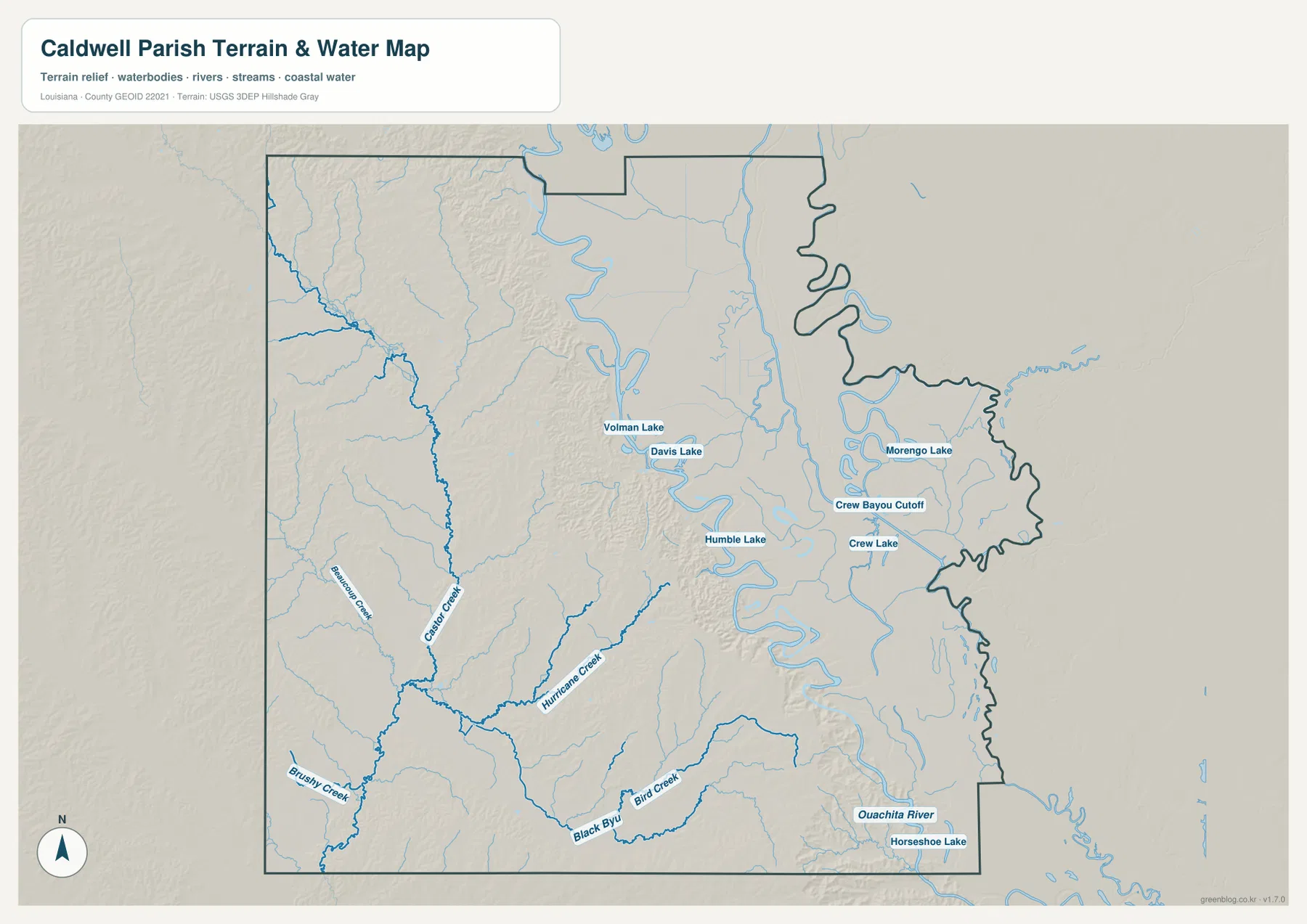
The Ouachita River is the strongest water feature on the eastern side. Several small lakes and cutoff channels sit near its bends, including Volman Lake, Davis Lake, Humble Lake, Morengo Lake, Crew Lake, and Crew Bayou Cutoff. The eastern boundary follows this winding river country rather than a simple straight line.
West of the river, Castor Creek provides one of the clearest long stream references. Brushy Creek joins the broader western drainage, while Hurricane Creek crosses the central-western side and Bird Creek appears farther south. These streams occupy narrow valleys through terrain that looks more uneven than the flatter land beside the Ouachita.
Horseshoe Lake appears near the southeastern boundary close to the Ouachita River. The Caldwell Parish Clerk of Court describes the parish as having alluvial land east of the river and hill land to the west, and that distinction is consistent with the supplied terrain-and-water map. The contrast is visible in the shaded relief even though this package does not include a separate elevation map.
This terrain-and-water file is a geographic reference, not a flood-insurance map, depth chart, navigation product, levee-safety document, legal shoreline record, or parcel survey. Current flood, boating, access, and property-boundary questions should be checked with FEMA, USGS, or local parish sources.
Columbia’s river setting and the western creeks reveal two different parts of Caldwell Parish
Columbia combines road access and river geography in one compact reference area. US 165, LA 4, and LA 133 meet near the town, while the Ouachita River lies close by. The Town of Columbia’s official site also emphasizes its location along the Ouachita, so the map’s river-side setting matches the community’s own geographic identity.
South around Grayson and Clarks, roads remain relatively simple, but the western side quickly becomes more defined by Castor Creek, Hurricane Creek, and Brushy Creek. The shaded relief is more noticeable there than along the eastern river plain. A reader comparing the road and water maps can see how the same short central corridor sits between two very different physical settings.
The eastern half is easier to follow by water names than by large towns. Morengo Lake, Crew Lake, Humble Lake, and the river’s broad bends provide better references than settlements in several places. Separating the parish into a central road corridor, western creek valleys, and eastern Ouachita lowlands gives a clear overall picture without relying on any one map layer.
Choose the Caldwell Parish file by the detail you need
The general map is the best starting point for Columbia, Grayson, Clarks, numbered roads, and the parish outline. The city-connections map is cleaner when the short distances from Clarks to Grayson and Columbia are the main concern. The terrain-and-water map is the strongest choice for the Ouachita River, western creeks, cutoff channels, and small lakes.
- General map: Use it for Columbia, Banks Springs, Grayson, Clarks, US 165, LA 4, LA 126, LA 127, LA 133, LA 557, LA 843, LA 844, LA 846, LA 847, LA 848, LA 849, and LA 850.
- City-connections map: Use it to compare Clarks with Grayson at about 2 miles and Columbia at about 6 miles in straight-line distance.
- Terrain and water map: Use it for Ouachita River, Castor Creek, Hurricane Creek, Brushy Creek, Bird Creek, Volman Lake, Davis Lake, Humble Lake, Morengo Lake, Crew Lake, and Horseshoe Lake.
Each original JPG measures 3638 × 2572 pixels in landscape orientation, preserving more small road, creek, and lake labels than the web previews. Keeping the original aspect ratio is recommended for printing. When using all three files, start with Columbia and Clarks, then compare Castor Creek on the west with the Ouachita River side.
Frequently Asked Questions
Which map is best for Columbia, Grayson, and Clarks?
The general parish map is the best choice because it combines Columbia, Banks Springs, Grayson, Clarks, US 165, LA 4, LA 133, LA 844, LA 850, and other numbered roads in one view.
Is the 6-mile Clarks-to-Columbia connection a driving distance?
No. The city-connections map shows about 6 miles from Clarks to Columbia and about 2 miles from Clarks to Grayson as straight-line distances. Actual driving distance and travel time depend on the available roads, bridges, and stream crossings.
Where can I see the Ouachita River and Castor Creek most clearly?
The terrain-and-water map shows Ouachita River, Castor Creek, Hurricane Creek, Brushy Creek, Bird Creek, and the named lakes around the eastern lowlands. It is a geographic reference rather than a flood, depth, navigation, or legal-boundary map.
Map File Information
The ZIP contains high-resolution JPG versions of the Caldwell Parish general map, city-connections map, and terrain-and-water map. Use the previews to check Columbia, Grayson, Clarks, major roads, the Ouachita River, and the western creek system before opening the original files.
- Included Files: Use only the versions confirmed in the article and supplied images
- File Type: Use the confirmed download contents
- Intended Use: Printing, education, presentations, and map-based projects
Related Maps
Sources and references
The geographic discussion is based primarily on the supplied Caldwell Parish maps, with official Louisiana, Columbia, Caldwell Parish court, and federal geographic sources used for context.
- Louisiana.gov – Caldwell Parish — official parish profile, parish seat, and municipality information.
- Town of Columbia official website — official town information and Ouachita River setting.
- Caldwell Parish Clerk of Court — official parish history and courthouse information.
- U.S. Census Bureau TIGER/Line Shapefiles — official geographic boundary and road data.
- USGS National Hydrography — federal hydrography background for rivers, creeks, lakes, and water features.
Green Map creates custom-edited map images using open geographic data sources such as geoBoundaries, Natural Earth, OpenStreetMap, and government open data. These maps are edited visual materials, not raw data files, and are provided for education, documents, presentations, and graphic reference.