You can download the Hampton County Map package on this page as an A3 high-resolution JPG ZIP while using the on-page maps to compare Hampton, Varnville, Estill, Yemassee, major roads, and the Coosawhatchie River system. The road-and-boundary map is the best starting point for county shape and travel direction, the city map isolates six mapped communities, and the terrain-and-water map brings rivers, swamps, ponds, branches, and gentle relief into view. Together they make it easier to understand why the central Hampton–Varnville area looks different from the long southeastern extension toward Yemassee.
Those three views answer different location questions without forcing every detail onto one image. The first makes the road pattern and county shape easy to follow. The second strips the view down to the six mapped communities so their positions can be compared quickly. The third shifts attention away from roads and toward the Coosawhatchie River, the Salkehatchie and Combahee river corridors, named swamps, ponds, branches, and subdued terrain relief. Reading them together gives Hampton County a much clearer geographic identity than the older outline-only version of this page.
Table of Contents
A county that stretches from Hampton toward Yemassee
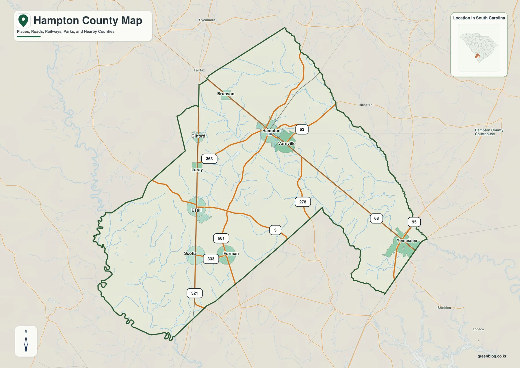
Hampton is the easiest place to begin because it sits near the center of the mapped road network and is also the county seat in the supplied county reference material. Varnville appears immediately to the southeast, close enough that both names can be used to orient the middle of the county. From there, the map opens in several directions: Brunson is northwest of Hampton, Estill is southwest, Furman lies farther south, and Yemassee is separated from the central cluster in the narrow southeastern part of the county.
The boundary itself is worth noticing. Hampton County has a broad western and southwestern body, a more angular northern edge, and a long southeastern section that reaches toward Yemassee. Nearby labels outside the boundary include places such as Fairfax, Sycamore, Islandton, Sheldon, and Lobeco. On the city-distribution map, the surrounding county names make the regional setting even clearer: Allendale County is shown to the west, Bamberg County to the north, Colleton County to the east, Beaufort County to the southeast, and Jasper County to the southwest.
Road numbers make the settlement pattern easier to follow
The road-and-boundary map labels routes 278, 63, 68, 95, 3, 321, 333, 363, and 601. Rather than forming one straight corridor, these roads spread away from the Hampton–Varnville area in several directions. The western side connects toward Brunson, Gifford, Luray, and Estill; routes through the southern interior lead toward Furman; and the southeastern arm continues toward Yemassee. This arrangement helps explain why the communities appear dispersed even though Hampton and Varnville form a close central pair.
Estill is especially easy to locate where the southwest road pattern becomes more distinct, while Furman sits farther southeast in the southern interior. Yemassee stands apart near the end of the southeastern extension, close to the map labels 95 and 68. The road map is therefore a good choice when the goal is to explain how the towns relate to one another or to locate a community before checking a more detailed street service. It is not intended to replace turn-by-turn navigation, and many minor roads are intentionally left in the background.
Six mapped communities reveal two very different parts of the county
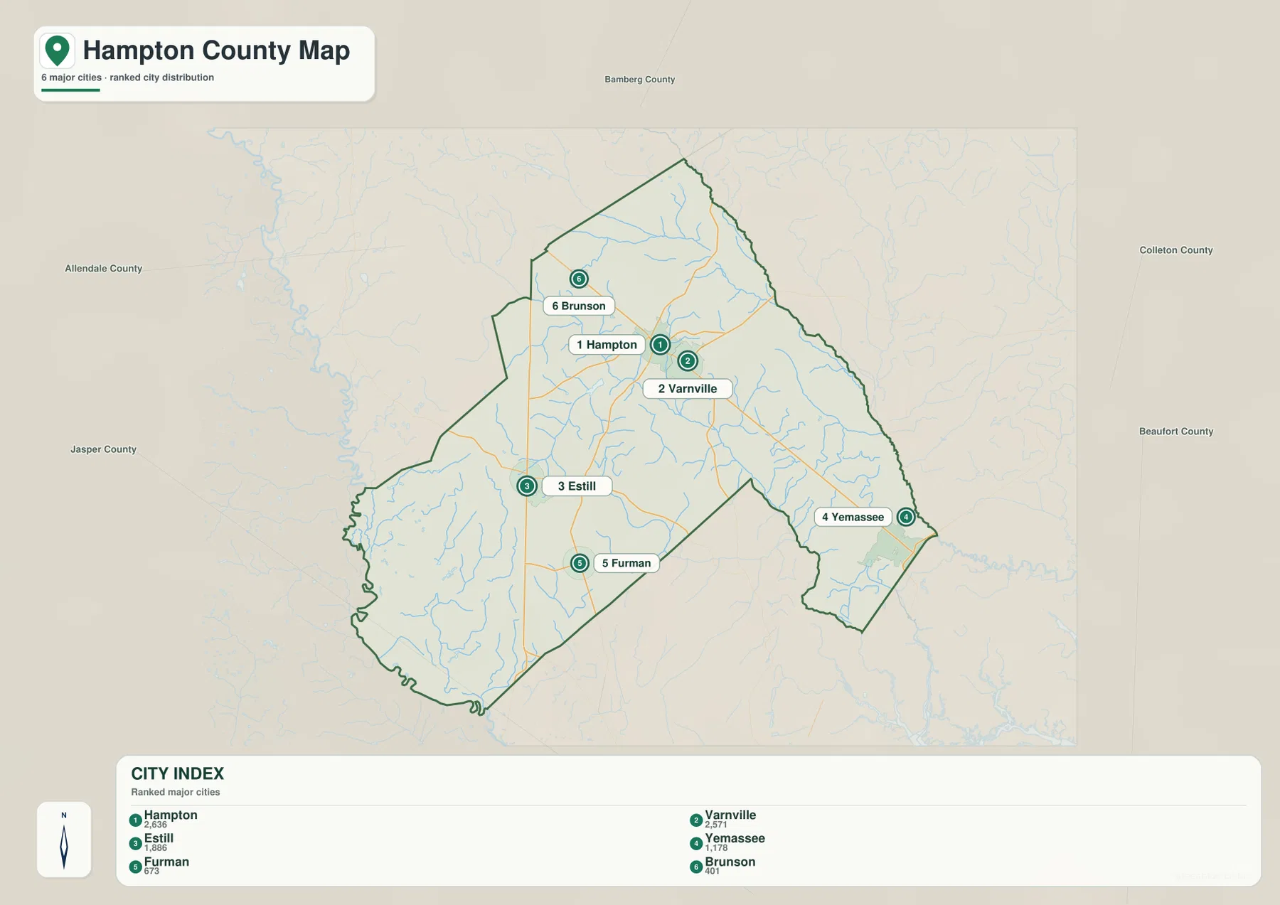
The city-distribution map ranks six communities in this order: Hampton, Varnville, Estill, Yemassee, Furman, and Brunson. Hampton and Varnville occupy the central part of the county and appear close to each other. Estill and Furman shift the pattern toward the southwest and south, while Brunson provides a northern reference. Yemassee is the outlier in the southeast, visually separated from the other five by the county’s elongated shape.
This view is useful because it removes much of the visual competition from road labels. A reader can immediately compare the central Hampton–Varnville pair with the more distant Estill and Yemassee positions. The county names printed around the map also show how the settlement pattern relates to neighboring jurisdictions. For example, Yemassee is close to the part of Hampton County that faces Beaufort County, while the broad western side faces Allendale and Jasper counties.
The Coosawhatchie River is the clearest waterway through the interior
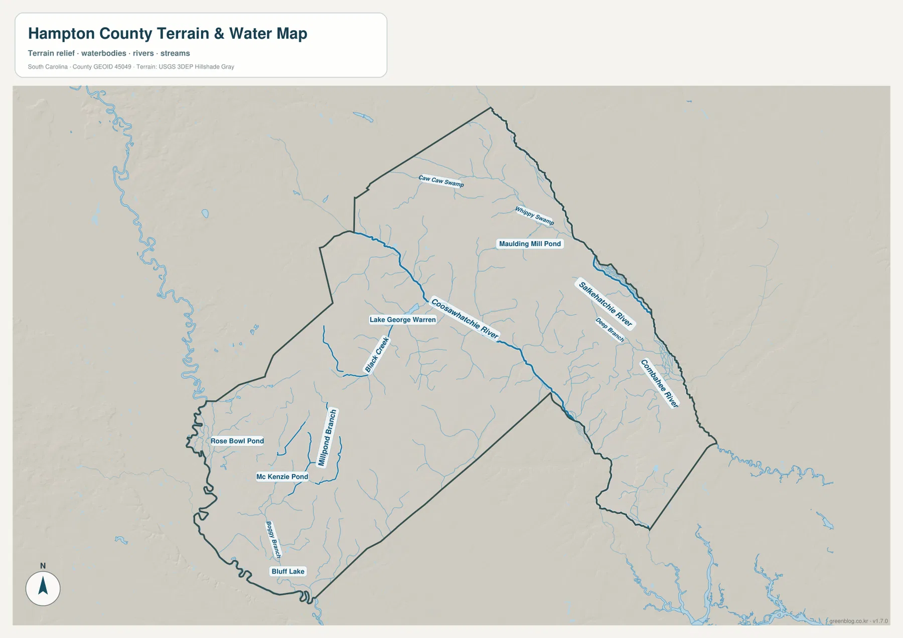
The terrain-and-water map changes the emphasis completely. The Coosawhatchie River crosses the interior and is drawn as one of the most prominent named waterways. To the east, the Salkehatchie River and Combahee River appear along the eastern side of the county, with Deep Branch identified between them. The north adds Caw Caw Swamp and Whippy Swamp, while a dense network of smaller blue lines fills the space between the larger named features.
Because the water layer is separated from the busy road map, it becomes easier to see that Hampton County is not defined by one river alone. The Coosawhatchie system has many tributary lines, and the eastern river corridor runs through a different part of the county. This distinction is helpful when comparing the central towns with the waterways: Hampton and Varnville are the easiest anchors on the road map, but the terrain-and-water view is the better source for understanding where named streams and wet areas appear.
Named ponds and swamps add detail beyond the major rivers
Several smaller names make the water map unusually informative. Caw Caw Swamp and Whippy Swamp are labeled in the north, with Maulding Mill Pond nearby. Lake George Warren and Black Creek appear west of the county center. In the southwest, Rose Bowl Pond, McKenzie Pond, Mill Pond Branch, Boggy Branch, and Bluff Lake create a separate group of named water features. These labels are useful for readers who need more than a simple county outline but do not need a full hydrographic database.
The shaded background provides a general sense of relief, but the map does not print contour lines or point elevations. It should not be used to measure exact height, grade, or survey positions. Likewise, the presence of a river, swamp, or pond on this page does not define a flood zone, property boundary, navigable channel, or regulatory buffer. The water map is a geographic reference for relative location and terrain context, not an engineering or legal product.
Choosing the right file for a report, class, or local reference
Start with the road-and-boundary map when the question is where Hampton, Estill, Brunson, Furman, or Yemassee sits inside the county. The labeled routes and outside place names make that image the strongest orientation tool. Use the city map when the main task is comparing the six communities without the distraction of every road and stream. Switch to the terrain-and-water map when the focus is the Coosawhatchie River, eastern river corridor, named swamps, ponds, and the overall physical background.
The files also work well as a sequence. A presentation can begin with the county map, move to the city distribution to explain where the communities are concentrated, and finish with the water map to show how rivers and wetland names occupy a different layer of the same county. For a printed handout, the high-resolution JPG versions provide more room for labels than the on-page previews. The ZIP keeps all three original map types together so they can be stored or printed as one county set.
Frequently Asked Questions
Why does Yemassee look separated from Hampton and Varnville?
Yemassee is mapped in the long southeastern extension of Hampton County, while Hampton and Varnville form a close pair near the center. The city map makes this contrast especially clear, and the road map adds the nearby 95 and 68 route labels around the Yemassee area.
Which map should I use to find the Coosawhatchie River and local ponds?
Use the terrain-and-water map. It labels the Coosawhatchie River, Salkehatchie River, Combahee River, Caw Caw Swamp, Whippy Swamp, Lake George Warren, Rose Bowl Pond, McKenzie Pond, Bluff Lake, and several branches and creeks that are much less prominent on the road-oriented map.
Do the downloadable files include detailed street navigation or flood zones?
No. The downloads are county reference maps for boundaries, mapped communities, roads at the supplied scale, waterways, and terrain context. They are not turn-by-turn street maps, parcel maps, flood-insurance maps, survey drawings, or regulatory water-boundary products.
Map File Information
The ZIP contains three A3 high-resolution JPG files matching the maps shown on this page.
- Included Files: county map, city map, terrain and water map
- File Type: JPG
Related Maps
Sources and map references
- South Carolina Association of Counties – County Information: county seat and county reference information
- U.S. Census Bureau TIGERweb: county boundary and location reference
- USGS National Hydrography: river and water-feature reference
- USGS 3D Elevation Program: terrain-relief reference
Green Map creates custom-edited map images using open geographic data sources such as geoBoundaries, Natural Earth, OpenStreetMap, and government open data.
These maps are edited visual materials, not raw data files, and are provided for education, documents, presentations, and graphic reference.