Carroll County occupies Maryland’s north-central uplands between the Pennsylvania line and the Patapsco River system. Westminster sits near the center, Taneytown, Union Bridge, and New Windsor spread across the west, Manchester and Hampstead anchor the northeast, and Mount Airy, Eldersburg, and Sykesville mark the southern side. The county is a landscape of rolling ridges and stream valleys rather than a single flat plain. This page explains the roads, settlement pattern, Pipe Creek and Patapsco tributaries, and elevation differences shown on the supplied maps, and the matching high-resolution JPG files can be downloaded in one ZIP archive. High-resolution map files are available for download in the section below.
Carroll County Government identifies Westminster as the county seat and lists eight incorporated municipalities: Taneytown, Hampstead, Manchester, Mount Airy, New Windsor, Sykesville, Union Bridge, and Westminster. The county’s official overview also notes the Pennsylvania line to the north, the Patapsco River along the south, Liberty Reservoir along part of the east, and the Monocacy River and Sam’s Creek along the west. Those boundaries help explain why the outline is irregular in several places instead of following a simple geometric shape.
Table of Contents
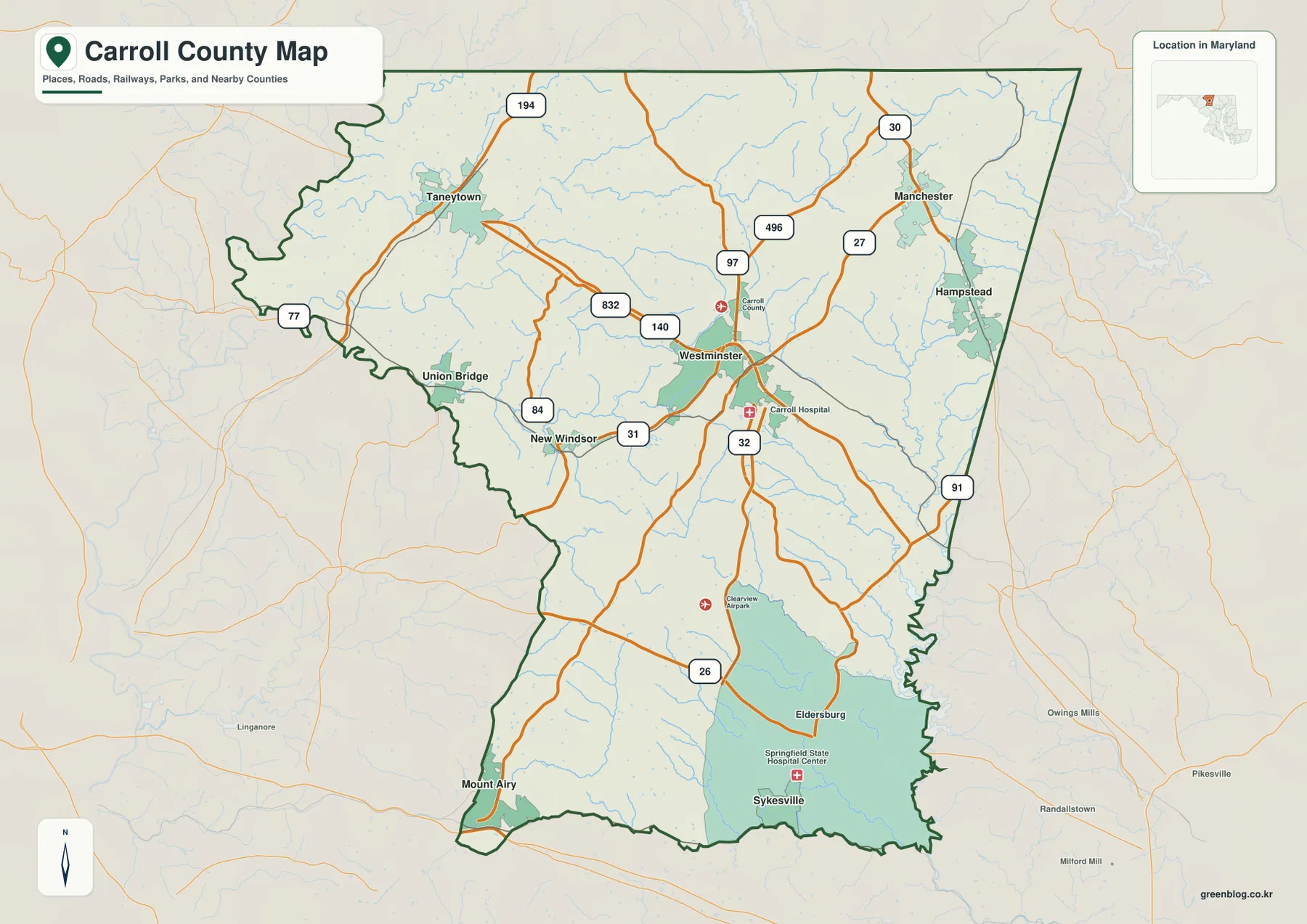
Westminster links a western chain of small towns with the northern and southern parts of the county
Westminster is the most useful starting point on the general county map. MD 140 crosses the central area from west to east, and MD 97 provides a strong north-south reference. From Westminster, New Windsor and Union Bridge lie to the west, while Taneytown is farther northwest. The communities are spread far enough apart that using Westminster and the major state highways as anchors is easier than trying to read the entire road network at once.
Taneytown occupies the northwestern part of Carroll County and is closely associated with the MD 194 corridor on the map. Union Bridge and New Windsor sit farther south and east, with MD 84 and MD 31 helping organize that part of the county. The western boundary is notably irregular and follows a landscape crossed by many small streams rather than a long straight survey line.
Manchester and Hampstead form the strongest pair in the northeast. MD 30 and MD 27 are prominent there, and MD 496 appears between the Manchester side and the MD 97 corridor. This is also one of the higher parts of the county on the elevation map, so the road pattern can be read together with the ridges and stream valleys rather than as a separate layer.
The southern third has a different settlement pattern. Eldersburg and Sykesville sit in the southeast, while Mount Airy lies close to the southwestern boundary. MD 26 leads toward the Eldersburg side, and MD 32 provides another north-south reference south of Westminster. Sykesville lies closer to the Patapsco drainage, where lower terrain and a more irregular boundary distinguish the southeast from the broad central uplands.
MD 140 and MD 97 establish the center before smaller highways branch toward the county edges
MD 140 and MD 97 are the easiest roads to use as a frame for Carroll County. MD 140 crosses Westminster and links the central county with areas to the west and east. MD 97 passes through the Westminster area and continues toward the Pennsylvania line, while its southern continuation helps orient the road network below the county seat. Once these two roads are located, the secondary state highways become much easier to place.
In the northeast, MD 30 and MD 27 serve the Manchester and Hampstead area, and MD 496 crosses the uplands west of those communities. West of Westminster, MD 832, MD 84, and MD 31 help define the New Windsor and Union Bridge side. These route numbers do not imply equal traffic or highway design; on this map they are most useful as landmarks for locating communities and the spaces between them.
The southern road pattern relies more heavily on MD 26, MD 32, and MD 91. MD 26 provides a clear reference toward Eldersburg, while MD 32 descends from the Westminster side toward the Sykesville area. MD 91 appears near the eastern boundary and helps place the Baltimore County-facing side. Mount Airy occupies the narrowing southwestern corner, where the road pattern is less centered on Westminster than in the middle of the county.
This is a geographic road map rather than a live traffic product. Construction, winter conditions, closures, and travel times can change on the state highways. Current trips should be checked with Maryland transportation information and a navigation service. The map is best used to understand direction, relative location, and which major routes are closest to each part of Carroll County.
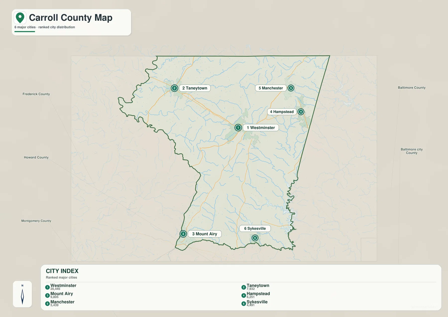
Six ranked places reveal a county with several small urban centers instead of one dominant cluster
The City Index ranks Westminster, Mount Airy, Taneytown, Hampstead, Manchester, and Sykesville. It prints the figures 20,445 for Westminster, 9,805 for Mount Airy, 7,932 for Taneytown, 6,251 for Hampstead, 5,439 for Manchester, and 4,491 for Sykesville. The image does not identify a reference year or statistical definition, so these values should not be presented as current population counts. Current demographic figures should come from the latest U.S. Census Bureau data.
The arrangement of the markers is more informative than the ranking itself. Westminster occupies the center, Taneytown is in the northwest, Manchester and Hampstead are close together in the northeast, and Mount Airy and Sykesville sit along the southern edge. The pattern shows that Carroll County’s larger settlements are distributed across several parts of the county rather than concentrated in one continuous city.
Two incorporated municipalities listed by Carroll County Government do not appear among the six ranked places: New Windsor and Union Bridge. The City Index is therefore not a complete municipal directory. It is a simplified map of selected major places, while the full county map is the better source for the entire incorporated-town pattern.
No connector lines or mileage values are shown between the ranked places. The graphic should not be used to estimate road distance from Westminster to Mount Airy, Sykesville, or Taneytown. For travel, use the general road map as orientation and a current routing service for actual mileage and time.
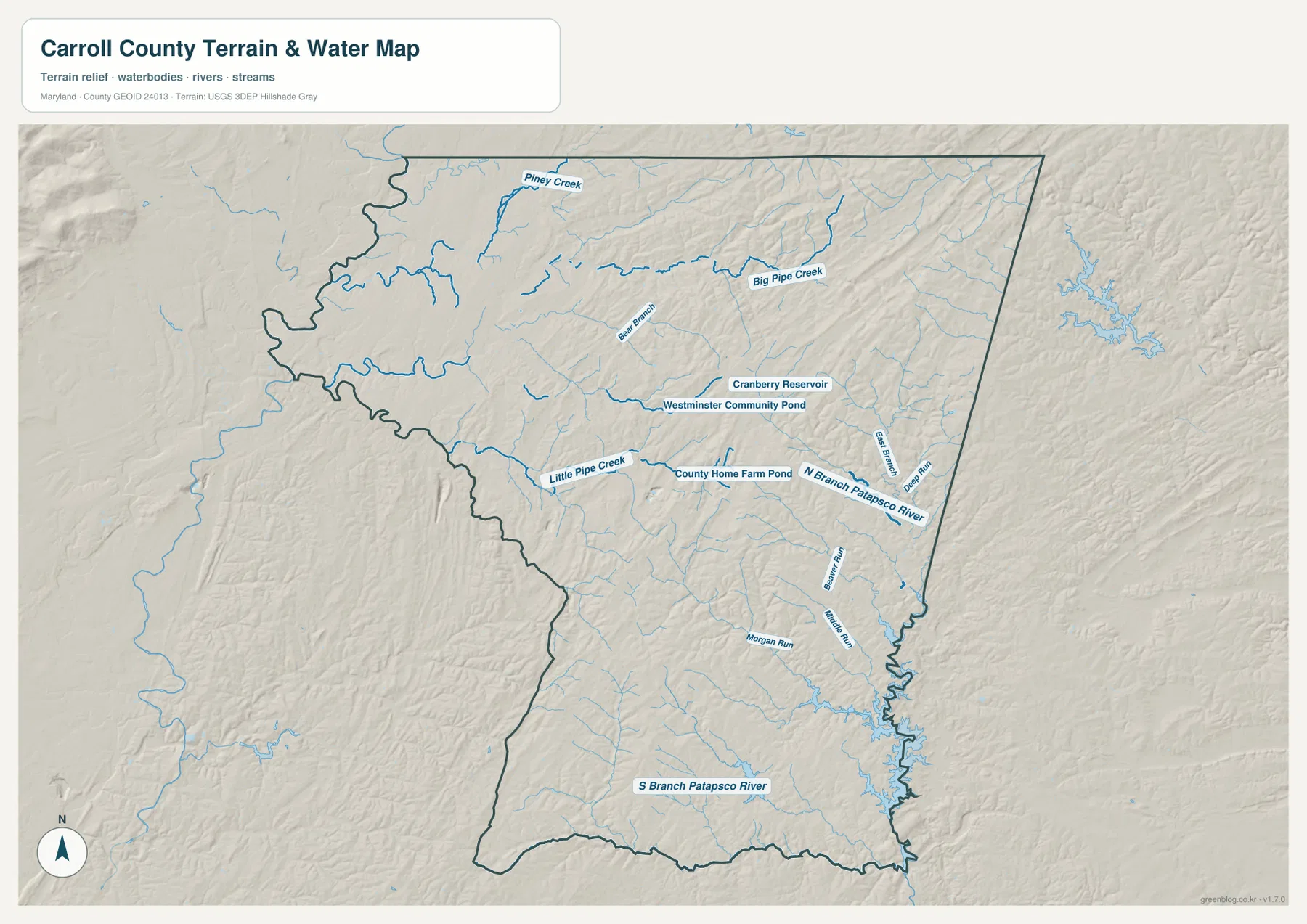
Big Pipe Creek and Little Pipe Creek cut across the northern and central uplands
The terrain-water map makes Big Pipe Creek and Little Pipe Creek two of the most useful natural landmarks. Piney Creek appears near the northwestern edge, while Big Pipe Creek crosses the northern interior through a landscape of many smaller tributaries. Bear Branch is labeled between the upper streams and Westminster, showing how the county’s rolling surface is divided by repeated narrow valleys.
Little Pipe Creek is more prominent southwest of Westminster. County Home Farm Pond is labeled nearby, and Cranberry Reservoir and Westminster Community Pond provide additional water references close to the county seat. These smaller water bodies are helpful for local orientation even though they are much smaller than the major river systems along the county boundaries.
The eastern and southeastern sides transition into the Patapsco drainage. North Branch Patapsco River is clearly labeled, with East Branch and Beaver Run nearby. Morgan Run and Middle Run occupy lower terrain farther south. The irregular eastern boundary becomes easier to understand when the water layer is compared with the road map because reservoirs and stream valleys help shape that side of the county.
South Branch Patapsco River appears across the southern portion of the map and reinforces the county government’s description of the Patapsco as a major southern boundary feature. The water layer is intended for geographic reference only. It does not show flood probability, legal water boundaries, depth, or current water quality, so flood, regulatory, or engineering work should use current FEMA, USGS, Maryland, or local data.
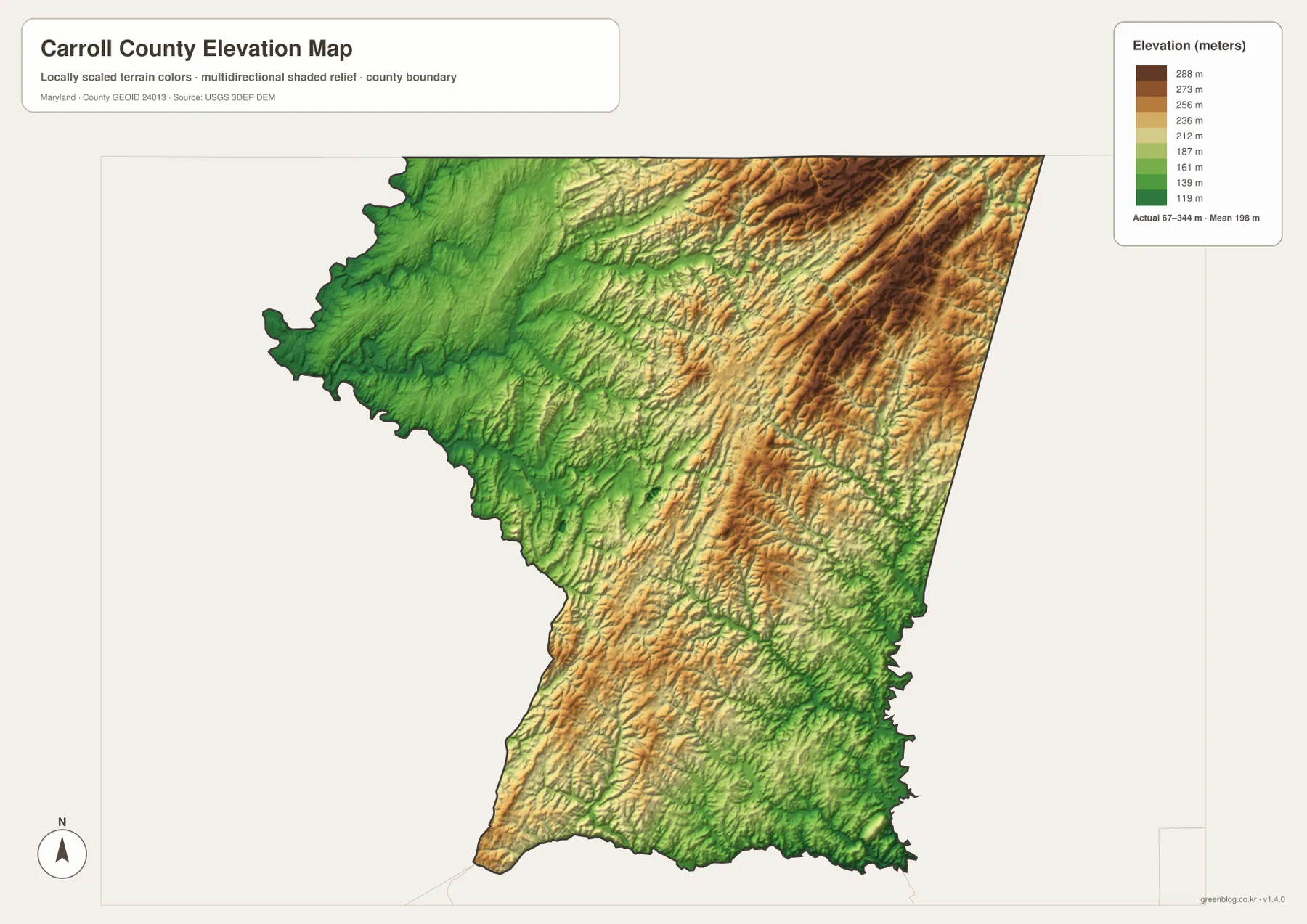
A 67–344 meter elevation range creates repeated ridges and valleys across the county
The elevation map reports an actual range from 67 to 344 meters and a mean elevation of 198 meters. Carroll County is not a high mountain county, but the relief is substantial enough to create a strongly rolling landscape. Browns and tans identify higher ridges, while greens follow lower valleys and drainage corridors. That contrast is much more pronounced than in Maryland’s flat Eastern Shore counties.
The northeastern and north-central parts contain broad areas of higher terrain, including the uplands around the Manchester-Hampstead side. Westminster also sits within a landscape of alternating ridges and lower stream corridors rather than on a uniformly flat surface. Comparing Big Pipe Creek and Bear Branch with the elevation colors shows how waterways occupy lower ground between the higher bands.
Lower green terrain spreads through parts of the northwest and along the Patapsco system in the southeast. The Mount Airy side rises again in places, producing another set of ridges near the southwestern edge. The result is not a simple west-to-east or north-to-south slope; Carroll County is a sequence of uplands separated by stream-cut valleys.
The elevation surface is useful for regional comparison, not parcel-level measurement. The 67–344 meter range should not be applied directly to a house, road, or property without authoritative elevation data. Surveying, engineering, drainage design, and flood assessment require USGS elevation products, professional survey information, and dedicated flood maps where appropriate.
Combining roads, streams, and elevation gives a clearer picture of Carroll County
The general county map is the best starting point for Westminster, Taneytown, Manchester, Sykesville, MD 140, MD 97, and the other state highways. The City Index is cleaner when the goal is simply to compare six ranked places. For natural geography, the water map shows Big Pipe Creek, Little Pipe Creek, Patapsco branches, and local reservoirs, while the elevation map explains why those streams occupy pronounced valleys between rolling ridges.
Carroll County Recreation & Parks provides a useful local example at Piney Run Park near Sykesville. The county describes Piney Run as its oldest developed park and notes a roughly 300-acre lake along with boating, fishing, trails, and other recreation. That official park information adds local context to the county’s southern water landscape, although the map on this page is not a park map and should not replace current visitor rules or facility information.
The downloadable originals are JPG files measuring 3638 × 2572 pixels each. Their landscape orientation works well for full-page documents and for enlarging individual areas such as Westminster, Manchester, or Sykesville in classroom material, presentations, and personal reference. Enlargement does not add live traffic, parcel boundaries, flood zones, or survey-grade elevation, so specialized decisions should always be checked against current official data.
Frequently Asked Questions
What is the county seat of Carroll County, Maryland?
Westminster is the county seat. Carroll County Government identifies it as the county seat, and the map shows it near the center where MD 140 and MD 97 provide strong road references.
Does the six-place City Index include every incorporated municipality in Carroll County?
No. The index marks Westminster, Mount Airy, Taneytown, Hampstead, Manchester, and Sykesville, while the county’s official municipal list also includes New Windsor and Union Bridge. The City Index is therefore a simplified ranked-place view rather than a complete municipal directory.
Can the 67–344 meter elevation range be used for surveying or flood decisions?
No. The range describes broad countywide relief only. Precise property elevation should come from authoritative USGS or professional survey data, and flood decisions should rely on current FEMA and local flood information.
Map File Information
The ZIP archive contains high-resolution JPG maps of Carroll County matching the map themes described on this page.
- Included Files: county and major roads map, City Index map, terrain and water map, elevation map
- Printable Size: 3638 × 2572 pixels each
- File Type: JPG
Related Maps
Sources and References
- Carroll County Government – Government
- Carroll County – Municipal Cities & Towns
- Carroll County – Piney Run Park
- U.S. Census Bureau – TIGER/Line Shapefiles
- USGS – National Hydrography
- USGS – 3D Elevation Program
Green Map creates custom-edited map images using open geographic data sources such as geoBoundaries, Natural Earth, OpenStreetMap, and government open data. These maps are edited visual materials, not raw data files, and are provided for education, documents, presentations, and graphic reference.