An Arkansas Map has to make 75 county names readable inside a state whose straight northern and southern edges contrast with river-shaped borders on the east and parts of the west. The supplied collection uses one consistent county framework in three treatments: pastel color, labeled black and white, and an unlabeled outline. Together they support reference reading, large-format printing, classroom recall, slides, and sourced annotations.
The labeled maps contain counties rather than cities. Pulaski appears near the center because it is a county name; Little Rock, the state capital located there, is not marked. “Arkansas” inside the east-central area identifies Arkansas County, while “Mississippi” in the northeast identifies Mississippi County. Both can be mistaken for larger geographic labels if the reader does not follow the county boundaries.
Every supplied Arkansas Map preview measures 1,200 × 849 pixels and uses a wide landscape composition. The protected collection confirms high-resolution files suitable for A3-format projects, with JPG, PNG, and ZIP formats listed in the source material. Readers should still work from the archive rather than enlarge a compressed page screenshot, especially when the smallest county names must remain legible.
The surrounding labels require caution. Missouri, Tennessee, Mississippi, and Texas appear around the state, but the western label says “Oklahoma City” rather than Oklahoma. The monochrome image also prints “Texas” at the lower-right edge where Louisiana should be. These errors do not change the internal county geometry, but the artwork should not be used as an unquestioned reference for neighboring states.
Table of Contents
Arkansas Map Versions Included
Arkansas has 75 counties, and all three images preserve their shared boundary network. The color and black-and-white editions retain county names, while the outline removes labels and fills. This consistency lets a learner begin with a visual reference, verify names on a restrained copy, and then reconstruct the arrangement on the blank version.
The map set does not plot cities, county seats, highways, rivers, terrain, elevation, population, or a scale bar. Even where an outer border follows a river, no waterway name is supplied. The collection is therefore best described as a county-boundary resource rather than a road map, physical map, or data product.
Several names reward careful reading. Hot Spring County is singular and appears beside Garland County; the city of Hot Springs is not a labeled feature. Independence County is a county name in the north-central area, and Arkansas County is a county rather than a repeated state title. These distinctions make the labeled versions useful as answer references.
Color County Map
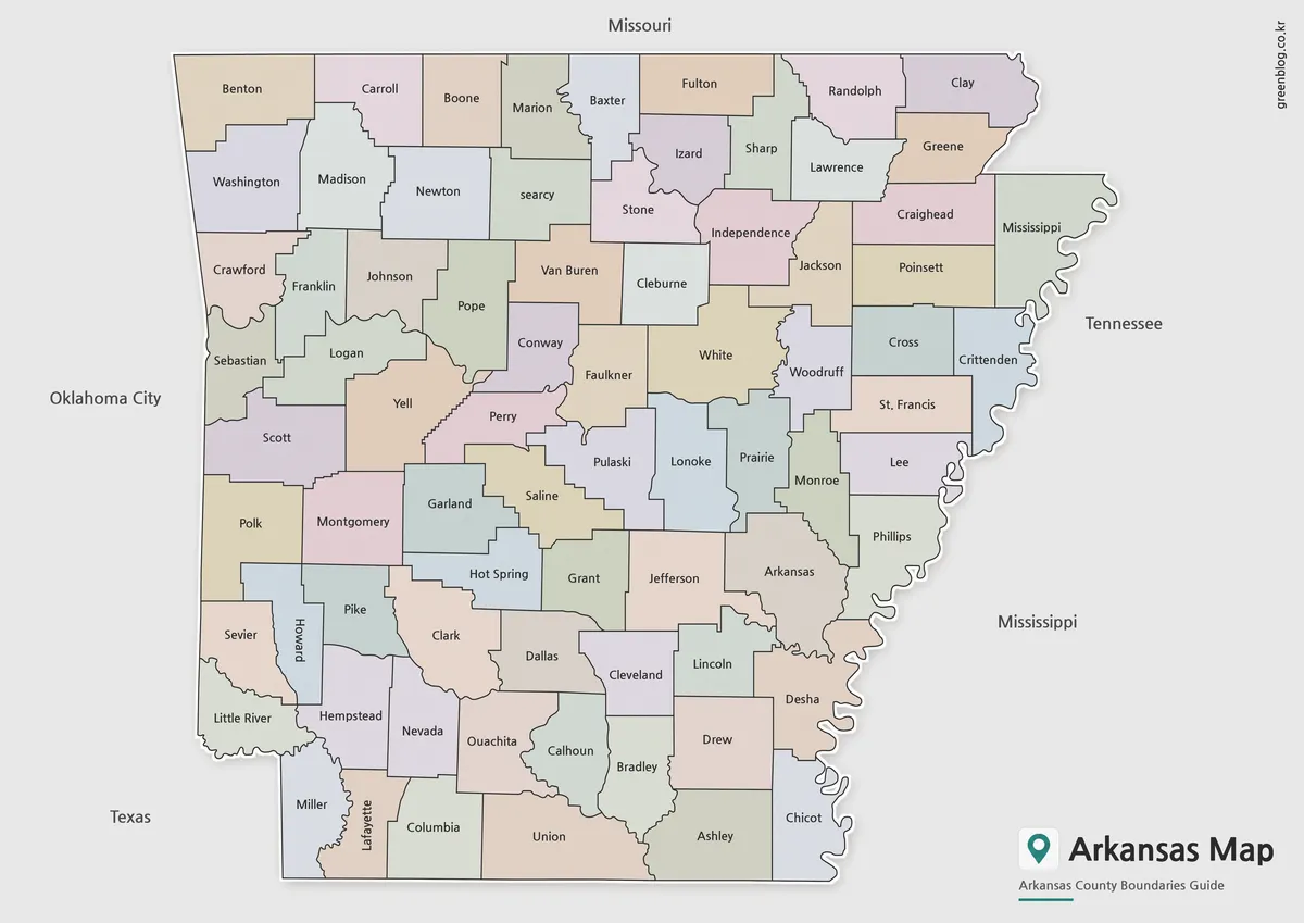
The color Arkansas Map assigns neighboring counties different muted fills, making shared borders easier to trace across dense parts of the state. The treatment is especially helpful around Pulaski, Saline, Garland, Perry, Faulkner, Lonoke, and Jefferson, where several irregular boundaries meet. It also separates the narrow eastern counties along the Mississippi River side.
The palette is decorative rather than thematic. No color represents population, elections, agriculture, climate, topography, or an official region. A presentation can use the map for quick county separation, but a data project should replace or supplement the pastel scheme with a documented legend, source, and reference date.
Northern counties such as Benton, Carroll, Boone, Marion, Baxter, Fulton, Randolph, and Clay form an easy-to-follow row beneath the Missouri label. Farther south, Miller, Lafayette, Columbia, Union, Ashley, and Chicot create much of the lower sequence. The color contrast helps readers compare those edges without implying that the counties belong to formal color groups.
Black and White Labeled Map
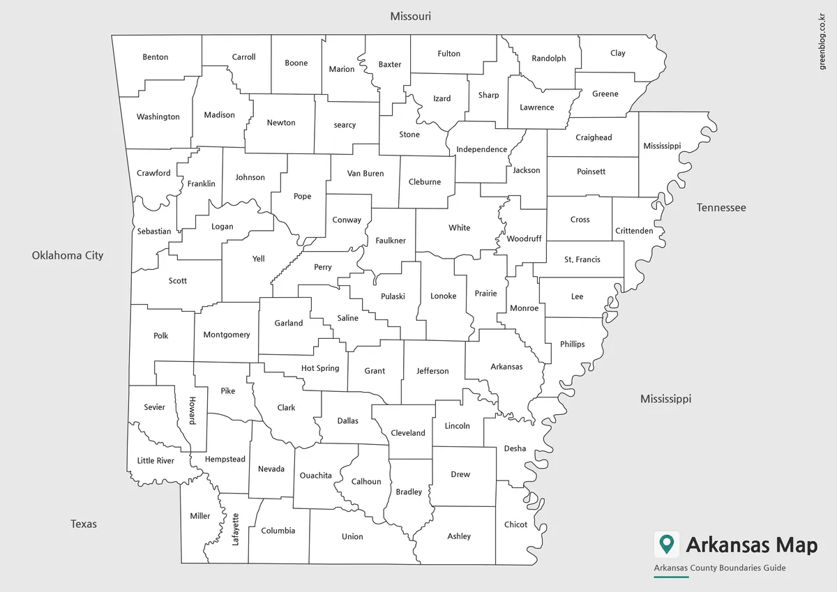
The black-and-white Arkansas Map removes the pastel interiors while retaining the county names, border lines, and surrounding labels. Dark text and white county fields become the primary information layers. It works as a reference sheet or answer key when a colored graphic would compete with surrounding text.
White interiors allow a reader to circle a few counties, underline names, or add simple symbols. Heavy shading can cover labels such as Lafayette, Howard, or St. Francis, so full-county data fills are better applied to the blank outline. The duplicate Texas label at the lower right should also be corrected or cropped when neighboring-state accuracy matters.
Some names are rotated because the county shapes are narrow. Howard and Lafayette run vertically in the southwest, and the eastern edge leaves little space beside the winding state border. A test print is advisable before producing a class set, particularly if the page is reduced below its intended A3 layout.
Blank Outline Map
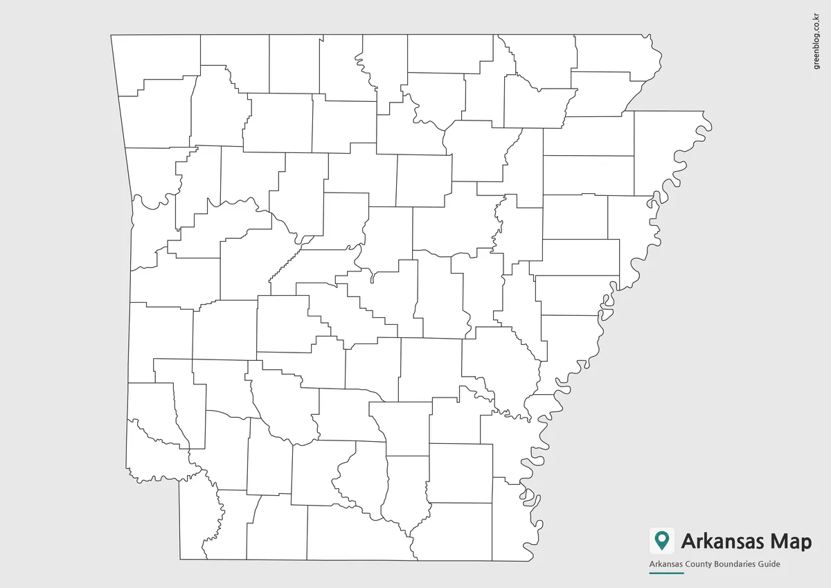
The blank Arkansas Map removes every county and neighboring-state label while preserving the internal divisions and outer shape. Because the inaccurate exterior wording disappears, this is the cleanest version for a current labeling exercise. Students can add all 75 county names, identify the counties along each state edge, or compare the straighter interior boundaries with the winding eastern border.
A designer can shade verified statistics by county, add project markers, or create a regional grouping. The image itself provides no categories, so new colors need a legend and source date. Area size should not be treated as a proxy for population, importance, or any other value.
The outline is a raster image, not an editable vector source or GIS layer. It can be annotated in presentation and graphics software, but the lines are not intended for precise measurement. Legal, electoral, emergency, or boundary-sensitive work requires a current authoritative dataset.
Regional Layout and Geographic Structure
Arkansas borders Missouri to the north, Tennessee and Mississippi to the east, Louisiana to the south, Texas at the southwest corner, and Oklahoma to the west. The Arkansas Map shows parts of this context through exterior labels, but it omits Louisiana and misnames Oklahoma. Use the county layer for internal orientation and a verified regional source for the complete neighbor relationship.
The state is often discussed through broad areas such as the Ozarks in the north, the Ouachita region in the west-central and southwest, and the Delta toward the east. Those physical and cultural regions are not drawn here. County boundaries can organize a comparison, but they should not be presented as if they exactly define mountain, forest, river, or agricultural regions.
The central counties provide a useful anchor. Pulaski contains Little Rock, though no capital marker is shown; Faulkner lies to the north, Lonoke to the east, Saline to the southwest, and Jefferson to the southeast. Starting with this cluster helps readers move outward toward the long northern row, the western counties, and the river-shaped east.
Designed for Printing and Presentation Use
An Arkansas Map can support a three-stage lesson: study the color reference, verify spellings with the monochrome sheet, and complete the outline from memory. A presentation can introduce the 75-county framework in color and then use the blank image for a sourced overlay. A report can select monochrome when names matter more than visual emphasis.
Preserve the 1,200 × 849 aspect ratio during resizing so the state does not become unnaturally narrow or tall. Keep an untouched master file, annotate a duplicate, and allow enough width for small names. For large output, use the confirmed high-resolution files from the ZIP instead of a page capture.
If a project includes neighboring states, replace “Oklahoma City” with Oklahoma and ensure Louisiana is shown along the southern edge. If it includes cities, add verified points separately and distinguish them from same-name counties. These small corrections preserve the collection’s usefulness without asking the county artwork to serve as a road or city map.
Frequently Asked Questions
Can I print the Arkansas Map in large formats?
Yes. The maps were prepared in high resolution and are suitable for larger print sizes, including A3-format projects.
Which version is best for presentations?
The color county map is usually the easiest to read when displayed on presentation slides.
Is the outline map editable?
Yes. The blank outline version is designed for annotations, graphic editing, and custom map projects.
Which map works best for classroom activities?
The black and white labeled map is often preferred for worksheets and educational exercises.
The protected archive contains matching color, labeled monochrome, and blank-outline versions. Select the file according to whether the task requires quick county separation, a name reference, or an empty base for recall and carefully sourced additions.
Map File Information
The archive provides three matching 75-county views for A3 projects, reference, lessons, presentations, and annotation.
- Included Versions: Color labeled map · Black-and-white labeled map · Blank outline map
- Printable Size: High-resolution A3 layout
- File Type: JPG and PNG files in a ZIP archive
- Intended Use: County reference · worksheets · slides · sourced overlays
Related Maps
Additional Resources
- U.S. Census Bureau: Arkansas Geography Guide — The federal reference confirms Arkansas’s 75 counties and explains their governmental structure.
Green Map creates custom-edited map images using open geographic data sources such as geoBoundaries, Natural Earth, OpenStreetMap, and government open data.
These maps are edited visual materials, not raw data files, and are provided for education, documents, presentations, and graphic reference.