An Armenia Map needs to distinguish ten marzes from Yerevan, which is governed separately from those regions. The supplied artwork calls the marzes “provinces,” a familiar English description, but the official Armenian term is marz. Together, the ten marzes and the capital area form the complete first-level administrative structure represented on these sheets.
Armenia is landlocked in the South Caucasus. Georgia is labeled to the north, Turkey to the west, Iran to the south, and Azerbaijan to the east. The map focuses on national and regional boundaries rather than roads or physical relief. It contains no scale bar, north arrow, transport network, terrain shading, or statistical legend.
The three previews share a 1200 × 849 landscape canvas and identical administrative geometry. The color edition combines pastel regions with blue water, the monochrome edition keeps the regional names on white interiors, and the outline edition removes all place labels. Each uses the same narrow northwest-to-southeast silhouette, with Syunik extending well below the central part of the country.
Lake Sevan is the large blue shape inside Gegharkunik, although the lake itself is not named. Yerevan is identified by a leader line pointing to its compact administrative area; there is no star or city dot. Several small detached or enclosed shapes also appear near the northern and eastern frontier, but the artwork gives them no names or status legend. It should not be used to settle enclave or border questions.
Table of Contents
Armenia Map Versions Included
The collection provides three levels of guidance while preserving the same ten marz boundaries and Yerevan area.
- Color administrative view: pastel marz fills, regional names, a Yerevan leader line, blue water, and four neighboring-country labels.
- Black-and-white labeled view: the same boundaries and region names without the color or visible water layer.
- Blank outline: national, marz, Yerevan, and small frontier shapes without names, water, or categorical fill.
The ten labels are Shirak, Lori, Tavush, Aragatsotn, Armavir, Kotayk, Gegharkunik, Ararat, Vayots Dzor, and Syunik. Every name is followed by “Province” in the completed versions. Yerevan appears without that suffix because the capital is not one of the ten marzes.
No other cities or regional centers are marked. Gyumri, Vanadzor, Gavar, Kapan, and the other marz centers do not appear as points or labels. A project that adds them should use a verified source and its own symbol key rather than assuming that the existing region names identify capital locations.
Administrative Color Map
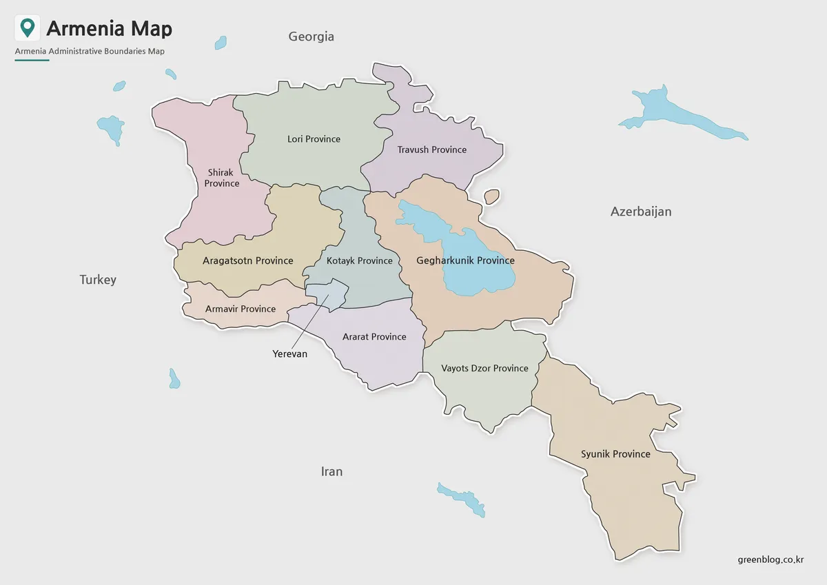
The color sheet uses muted pink, green, purple, tan, blue-gray, and cream fills to separate adjacent marzes. The colors are categorical only. They do not represent population, elevation, climate, political results, or economic activity, and they do not distinguish a formal hierarchy among the regions.
The northern tier begins with Shirak, Lori, and Tavush. Aragatsotn and Armavir occupy the west-central side, while Kotayk sits around the compact Yerevan area. Ararat stretches southeast from the capital zone. Gegharkunik contains Lake Sevan, Vayots Dzor forms the next southern transition, and Syunik creates the long lower extension.
Blue water makes Lake Sevan the strongest physical feature in the target country. Several blue shapes also appear beyond Armenia’s boundary, but none is labeled. The surrounding countries are printed on a shared gray background rather than divided into their own provinces, keeping visual emphasis on Armenia’s internal structure.
This is the best completed version for explaining the national arrangement at a glance. A presenter can begin with the three northern marzes, identify the capital’s separate shape, use Lake Sevan to locate Gegharkunik, and then follow Ararat, Vayots Dzor, and Syunik toward the south. Any thematic data added later needs a new legend and source.
Black and White Labeled Map
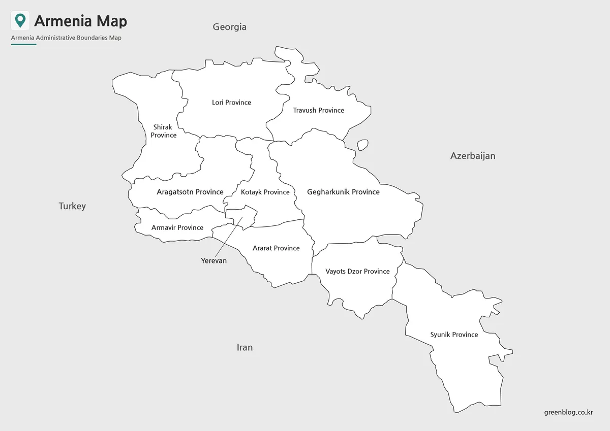
The monochrome sheet removes the pastel fills and all blue water while retaining the ten province names and neighboring-country labels. Lake Sevan is not outlined, so Gegharkunik becomes a continuous white area. The Yerevan leader line remains, and the compact capital boundary can still be distinguished between the surrounding central regions.
This image has two visible production faults. The large map title is missing, and the subtitle is printed as “Ainistrative Boundaries Map” rather than “Administrative Boundaries Map.” At the far left, the capital label is cropped so that only “evan” remains. These issues do not alter the boundary lines, but they matter in a report or classroom handout.
Use the color version as the answer key when a complete title and capital label are required. If the monochrome sheet must be published, correct the subtitle and restore the full Yerevan label first. Cropping the page more tightly would make the existing capital-label problem worse, so leave extra space on the left during layout work.
Blank Outline Map for Editing
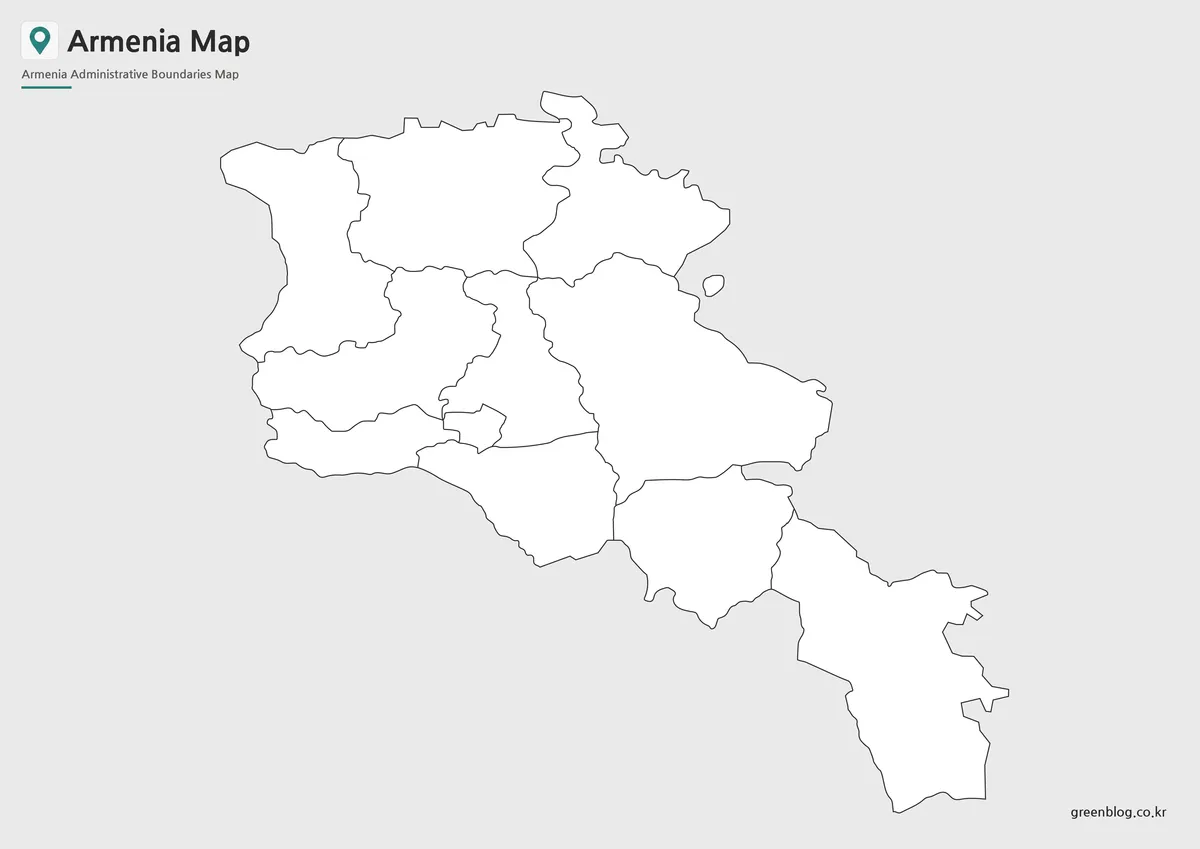
The outline edition removes all marz names, the Yerevan text and leader line, neighboring-country labels, Lake Sevan, and the other blue water shapes. It preserves the national perimeter, internal regional boundaries, the compact capital boundary, the small frontier shapes, the title, and the site mark.
For a labeling exercise, start with Shirak, Lori, and Tavush across the north. Add the west-central and capital-area units, then use the broad eastern Gegharkunik shape as an anchor before continuing through Ararat, Vayots Dzor, and Syunik. A second pass can redraw and name Lake Sevan if physical geography is part of the lesson.
The supplied preview is a WebP raster image, not an SVG, GIS layer, or editable vector file. It can accept text, arrows, colors, and icons in an image editor, but the marz polygons are not promised as separately selectable objects. Preserve the 1200 × 849 aspect ratio when resizing to avoid stretching Syunik or compressing the northern border.
Regional Structure and Geographic Layout
The map’s strongest structural pattern is the shift from a broad northern and central body to the narrow southern extension. Lori and Tavush form much of the northern edge below Georgia. The Yerevan area lies west of center, Lake Sevan dominates the east-central composition, and Syunik reaches toward Iran at the bottom.
The four international neighbors provide orientation without additional internal detail. Georgia and Iran appear above and below the country, Turkey occupies the western side, and Azerbaijan is labeled to the east. Because the artwork does not provide border notes, dates, or a legal-status key, users should consult an authoritative current source for any project focused on disputed or enclave boundaries.
The representation is most useful for first-level administration. It does not show communities within the marzes, Yerevan’s districts, regional capitals, mountain ranges, rivers, highways, or border crossings.
Designed for Printing, Education, and Presentations
Choose the color edition for a completed introductory slide, the monochrome edition only after correcting its visible text defects, and the outline edition when readers should supply names or create a sourced data graphic. The same geometry across all three allows a teacher to move from explanation to assessment without changing the boundary arrangement.
The package description identifies high-resolution JPG and PNG files prepared for A3 output, while the three web previews inspected here are WebP. Before large-format printing, retain the landscape proportion and run a test sheet. The small Yerevan area, leader line, and frontier shapes provide better quality checks than the large Syunik or Gegharkunik labels.
For a thematic project, replace the decorative region colors with a documented scale, state the data year, and clarify whether Yerevan is treated separately from the ten marzes. If Lake Sevan or regional centers are added, distinguish physical and point symbols from administrative boundaries so readers do not confuse different information layers.
Frequently Asked Questions
Can I print the Armenia Map in A3 size?
Yes. The files were prepared in high resolution and are suitable for A3 printing.
Which Armenia Map version is best for presentations?
The color administrative map is usually the easiest to read during presentations.
Is the Armenia Map outline version editable?
Yes. The outline version was created specifically for editing, annotation, and graphic design projects.
Does the Armenia Map include provincial boundaries?
Yes. All included versions display Armenia’s provincial boundaries, although labeling varies depending on the map style.
Does the map show the capitals of all ten marzes?
No. It labels each marz and gives Yerevan a leader line, but it does not mark Gyumri, Vanadzor, Ashtarak, Artashat, Armavir, Gavar, Hrazdan, Kapan, Ijevan, or Yeghegnadzor as regional centers. Add verified city points and a legend if those locations are needed.
Map File Information
The archive groups the color, labeled monochrome, and blank administrative views displayed above.
- Included Versions: Color, black and white, and outline
- File Type: Image files in a ZIP archive
- Intended Use: Lessons, reports, presentations, regional study, and annotation
Related Maps
Additional Resources
The official Government of Armenia regions page confirms the ten-marz structure and Yerevan’s separate administrative treatment.
Green Map creates custom-edited map images using open geographic data sources such as geoBoundaries, Natural Earth, OpenStreetMap, and government open data.
These maps are edited visual materials, not raw data files, and are provided for education, documents, presentations, and graphic reference.