A Korean version of this map page is available. View Korean Page
A North Macedonia Map is useful when you need a clear visual reference for the central Balkan region. North Macedonia is a landlocked country located north of Greece and bordered by Kosovo, Albania, Bulgaria, Serbia, and Greece. Because it sits between several Balkan countries, a simple location image is often not enough for classroom lessons, regional comparison posts, or presentation slides. A labeled printable map makes it easier to understand how the country connects with its neighbors.
This printable North Macedonia Map collection includes three versions: a color map, a black and white map, and a blank outline map. The maps were prepared in A3 size and arranged for high-resolution printing, so they can be used for classroom materials, blog graphics, study resources, presentation visuals, and editable infographic projects. The collection also includes bilingual Korean and English labels, which makes it convenient for users who need both local-language and English place-name references.
North Macedonia’s layout is especially helpful to show with a map because the country is compact but regionally connected in several directions. The capital, Skopje, sits in the northern part of the country, while lakes and border areas help define the map visually. For educational use, the map can support lessons about the Balkans, neighboring countries, inland geography, and regional identity. For design work, the outline version can become a base map for highlighting routes, administrative areas, or statistical data.
During the map design process, the administrative boundaries were organized in Illustrator, and the color balance was refined in Photoshop. The map was prepared with printing in mind, including CMYK color mode and adjusted line weight for better readability. Labels, border lines, and lake areas were checked so they remain clear when the map is enlarged or printed at A3 size.
Table of Contents
North Macedonia Map Overview
North Macedonia is located in the central part of the Balkan Peninsula. It does not have a coastline, so its regional position is best understood through its borders with surrounding countries. Greece lies to the south, Bulgaria to the east, Albania to the west, Kosovo to the northwest, and Serbia to the north.
The country officially changed its name from Macedonia to North Macedonia in January 2019. For map users, this is an important detail because older maps or references may still use the former name. A current North Macedonia Map helps avoid confusion when preparing educational resources, country comparison pages, or Balkan region materials.
Because the country is relatively small in area, label placement and boundary clarity matter. A compact map can become difficult to read if labels, lakes, and border lines are not balanced carefully. This collection was prepared to keep those details clear for both screen viewing and printed use.
Map Styles Included
The downloadable North Macedonia Map collection includes:
- Color administrative map
- Black and white printable map
- Blank outline map
Each version is intended for a different type of use. The color map works well for visual comparison and web content, the black and white map is better for printing and document layouts, and the outline map is suited for editing, custom labeling, and data-based graphics.
Color North Macedonia Map
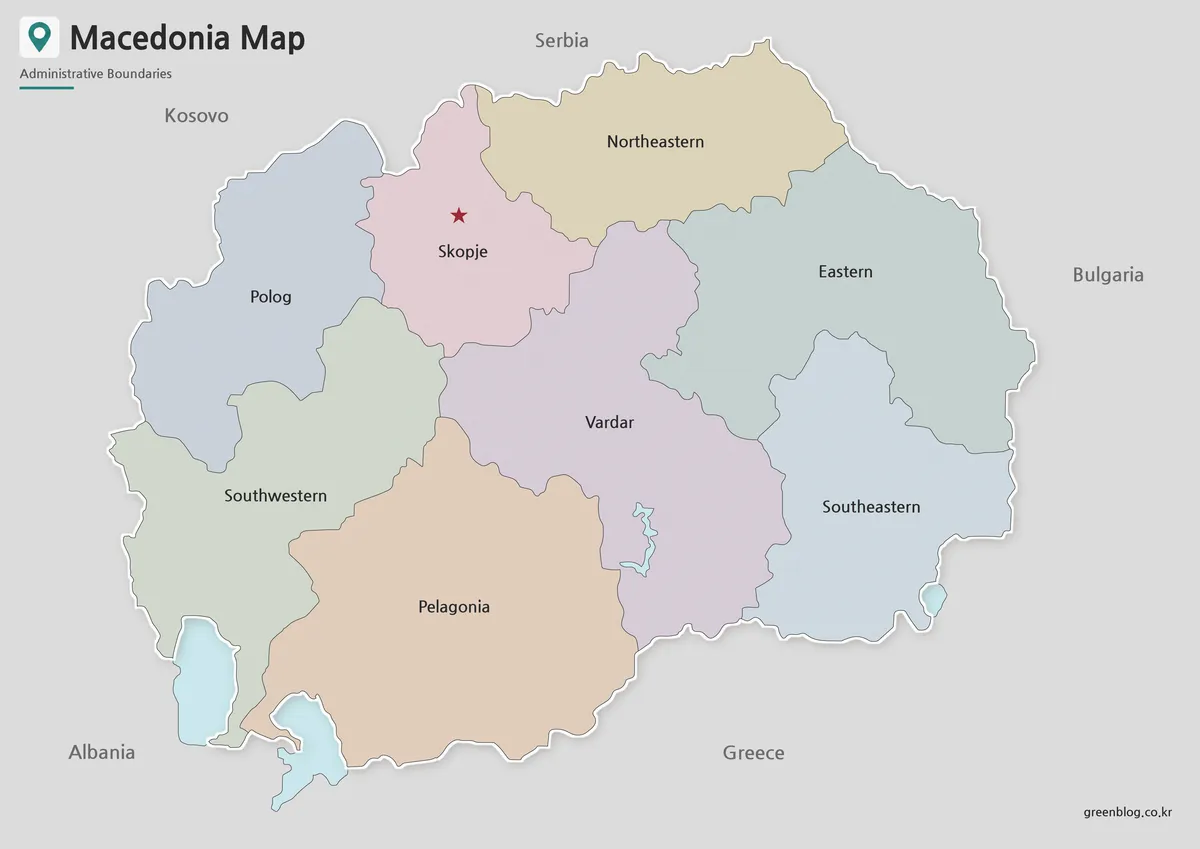
Designed with color-coded administrative areas, this version helps users read the country’s regional structure quickly. Since North Macedonia borders several countries in a compact area, color separation makes it easier to distinguish the internal map layout while still understanding the surrounding Balkan context.
The map includes Korean and English place names, making it useful for bilingual materials, educational posts, and reference graphics. Lakes are marked with a separate color so they are easier to identify within the inland landscape. This is especially helpful when the map is used in geography lessons or regional comparison slides, where water features and borders need to be recognized quickly.
The color version is also a strong choice for blog images, presentation slides, and country introduction graphics. It gives readers a more immediate sense of place than a plain outline, while still keeping the overall design simple enough for practical use.
Black and White Printable Version
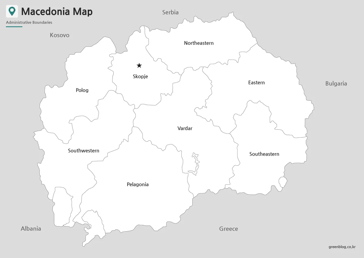
For reports, worksheets, and classroom printing, the black and white version provides a cleaner layout. Removing the color background makes labels easier to read and helps reduce visual clutter, especially when the map is printed on standard office or school printers.
North Macedonia’s compact shape means that labels, lake outlines, and boundary lines need enough contrast to remain clear. This version keeps the background white while preserving essential geographic and administrative information. It is useful for printed handouts, student assignments, study sheets, and presentation notes.
The simplified style also gives users room to add their own markings. Teachers may highlight neighboring countries, students may circle Skopje or major lake areas, and bloggers may add arrows or short annotations for explanatory images.
Blank North Macedonia Outline Map for Editing
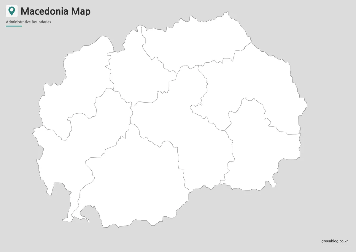
The outline map removes colors and labels, leaving a clean boundary-based map for custom work. This version is the most flexible choice when users want to create their own visual material rather than use a finished labeled map.
Designers can add custom colors, icons, regional data, travel routes, city markers, or presentation highlights. Teachers can use the blank North Macedonia outline map for labeling exercises, classroom coloring activities, or Balkan region worksheets. It also works well for infographic projects that compare North Macedonia with nearby countries such as Albania, Bulgaria, Greece, Kosovo, and Serbia.
Because unnecessary visual elements are removed, the outline map functions as a practical working base. Users can build a new map style from it, emphasize specific regions, or combine it with other Balkan country maps for comparison materials.
Prepared for Printing and Presentation Use
This map collection was created in A3 size and prepared with high-resolution output in mind. The line thickness, label placement, and color balance were adjusted so the maps remain readable when enlarged or printed.
The color version is suitable for visual display, the black and white version is better for clean printing, and the outline version is best for editing. Together, the three map styles give users more flexibility than a single finished image.
Practical Uses
This North Macedonia Map collection can be used for:
- Classroom geography lessons
- Balkan region comparison materials
- Student worksheets and reports
- Presentation slides
- Blog graphics and country introduction posts
- Travel-related visual references
- Infographic design projects
- Custom map editing and annotation
Because North Macedonia is surrounded by several countries and located in the central Balkans, the map is especially useful when explaining border relationships, regional position, and inland geography.
Frequently Asked Questions
Can I print this North Macedonia Map in A3 size?
Yes. The maps were prepared for A3 high-resolution printing, making them suitable for classroom handouts, reports, and presentation materials.
Which version is best for printed documents?
The black and white map is usually the best option for printing because it keeps labels clear and reduces color use.
Does the map include English labels?
Yes. The map includes Korean and English labels, making it useful for bilingual reference materials.
Are lakes shown on the map?
Yes. Major lake areas are marked separately so they can be identified more easily.
Which North Macedonia Map is best for editing?
The blank outline map is the best choice for editing. It works well for adding colors, labels, statistics, icons, or route markers.
Download Information
The download package includes the color map, black and white map, and outline map. Choose the version that fits your project, whether you need a finished labeled map, a clean printable version, or a blank base map for custom editing.
North Macedonia Map Download
This download package includes color, black and white, and outline versions of the North Macedonia Map. The maps are designed for A3 high-resolution printing, classroom use, presentation materials, infographic projects, and editable visual work.
- Included Maps: Color map, black and white map, outline map
- Print Size: A3 high-resolution format
- Color Mode: CMYK
- Intended Usage: Printing, education, presentations, infographics, editing
Related Maps
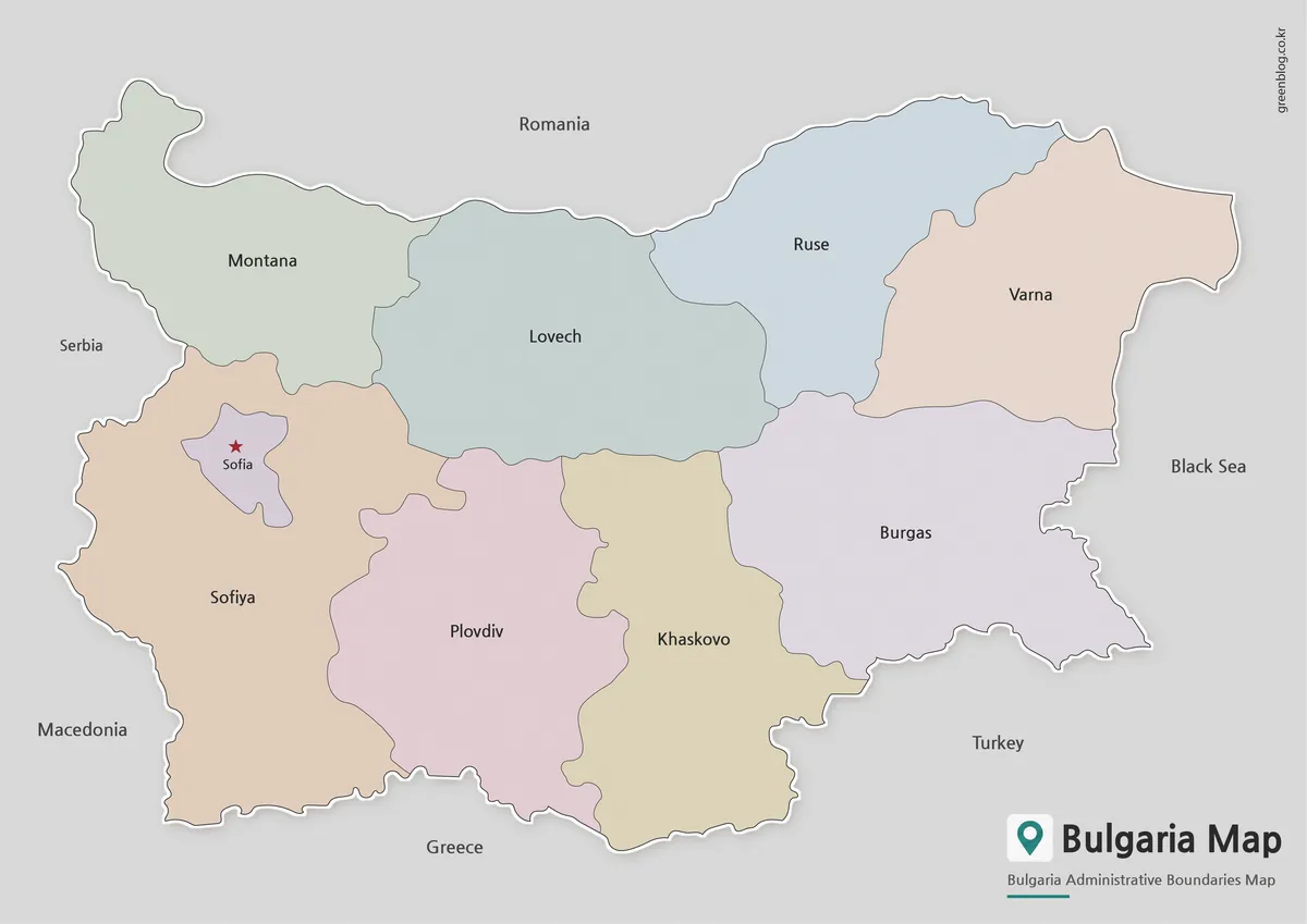
- Bulgaria Map with Regions and Sofia – Color, Detailed, and Outline Versions
- Belarus Map Collection: Printable Administrative, Labeled, and Outline Maps
- High-Resolution Austria Map for Education, Travel, and Graphic Projects
- Printable Armenia Map Download – High Resolution A3 Map Set
Additional Resources
- Humanitarian Data Exchange – North Macedonia Administrative Boundaries : North Macedonia administrative boundary dataset useful for GIS reference, regional boundary checks, and map-based projects.
Green Map creates custom-edited map images using open geographic data sources such as geoBoundaries, Natural Earth, OpenStreetMap, and government open data.
These maps are edited visual materials, not raw data files, and are provided for education, documents, presentations, and graphic reference.