Pasquotank County occupies a long, narrow part of northeastern North Carolina, with Elizabeth City providing the clearest urban reference and a dense network of rivers, creeks, and drainage channels shaping the rest of the map. The county stretches from the US 158 area in the northwest toward NC 34 and Glen Cove in the southeast. Around Elizabeth City, roads and developed areas are easy to identify, while farther south the map becomes more water-oriented as small creeks lead toward Albemarle Sound.
This page includes three views of the county: a general map with boundaries, roads, and place labels; a city-distribution map that highlights the main ranked city; and a terrain-and-water map with the Pasquotank River, Albemarle Sound, canals, and named creeks. You can download the matching high-resolution A3 JPG files together in one ZIP from the map file box below. The WebP images in the article are quick previews, while the JPG files are better suited to printing, enlarged viewing, and document use.
Table of Contents
Elizabeth City is the best anchor for following US 17, US 158, and NC 34
The general county map makes Elizabeth City the easiest place to begin. Its developed area is shown near the center-east of the county, and several labeled sites appear nearby, including the Pasquotank County Courthouse, Pasquotank-Camden EMS, and Elizabeth City State University. Those labels are not meant to define exact campus or facility boundaries; they simply make the Elizabeth City area easy to recognize when viewing the county at this scale.
US 17 is the most prominent north-south road on the map. It enters from the north and continues through the Elizabeth City area before heading farther south. US 158 crosses the northwestern part of the county near Lynch’s Corner, providing a second major reference for the upper end of the map. To the southeast, NC 34 leads toward Glen Cove, while Rabbit Corner appears southwest of Elizabeth City and helps distinguish the central urban area from the more rural southern portion.
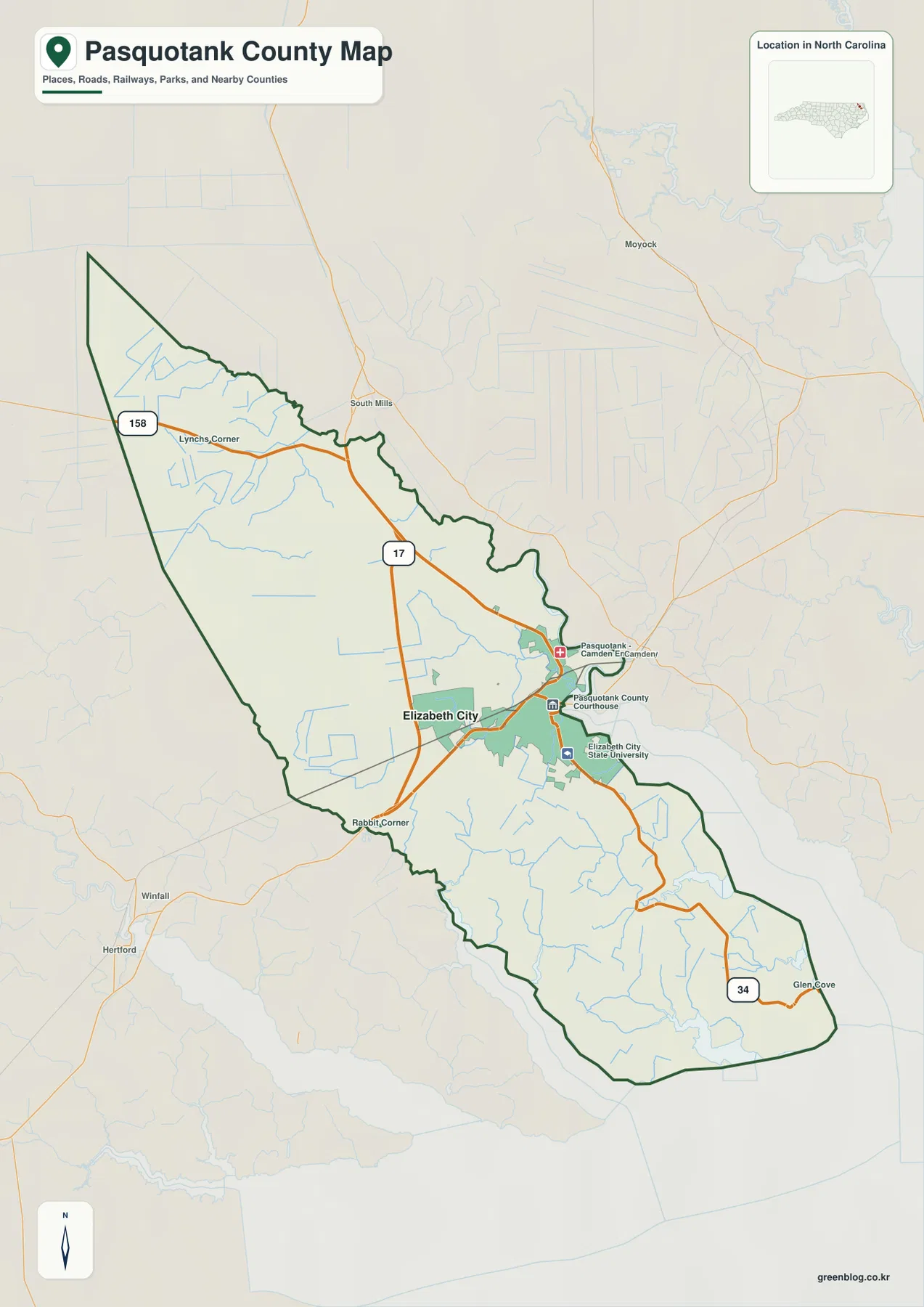
Labels outside the county help with regional orientation. South Mills and Moyock appear to the north, while Winfall and Hertford are visible to the southwest. They should not be mistaken for places inside Pasquotank County, so the dark county boundary is the first line to check before reading nearby labels. Once the boundary is clear, the road pattern makes it easy to see how the northwest, Elizabeth City, and the southeastern end of the county relate to one another.
The city map emphasizes one major center rather than a chain of ranked towns
The city-distribution map is unusually simple. It identifies Elizabeth City as the single ranked major city in the supplied map set, and the City Index displays the number 18,871 beside the name. That number is the value printed on the map itself; this article does not reinterpret it as a separate current population estimate. The main point of the graphic is the location of Elizabeth City inside the county, not a detailed demographic comparison.
This one-city emphasis is useful when it is compared with the general map. Lynch’s Corner, Rabbit Corner, and Glen Cove are visible as smaller geographic references, but they are not presented as competing major urban centers. Elizabeth City therefore works as the primary reference for county administration and urban orientation, while the general map is the better choice for finding the smaller places, highway junctions, and road directions around it.
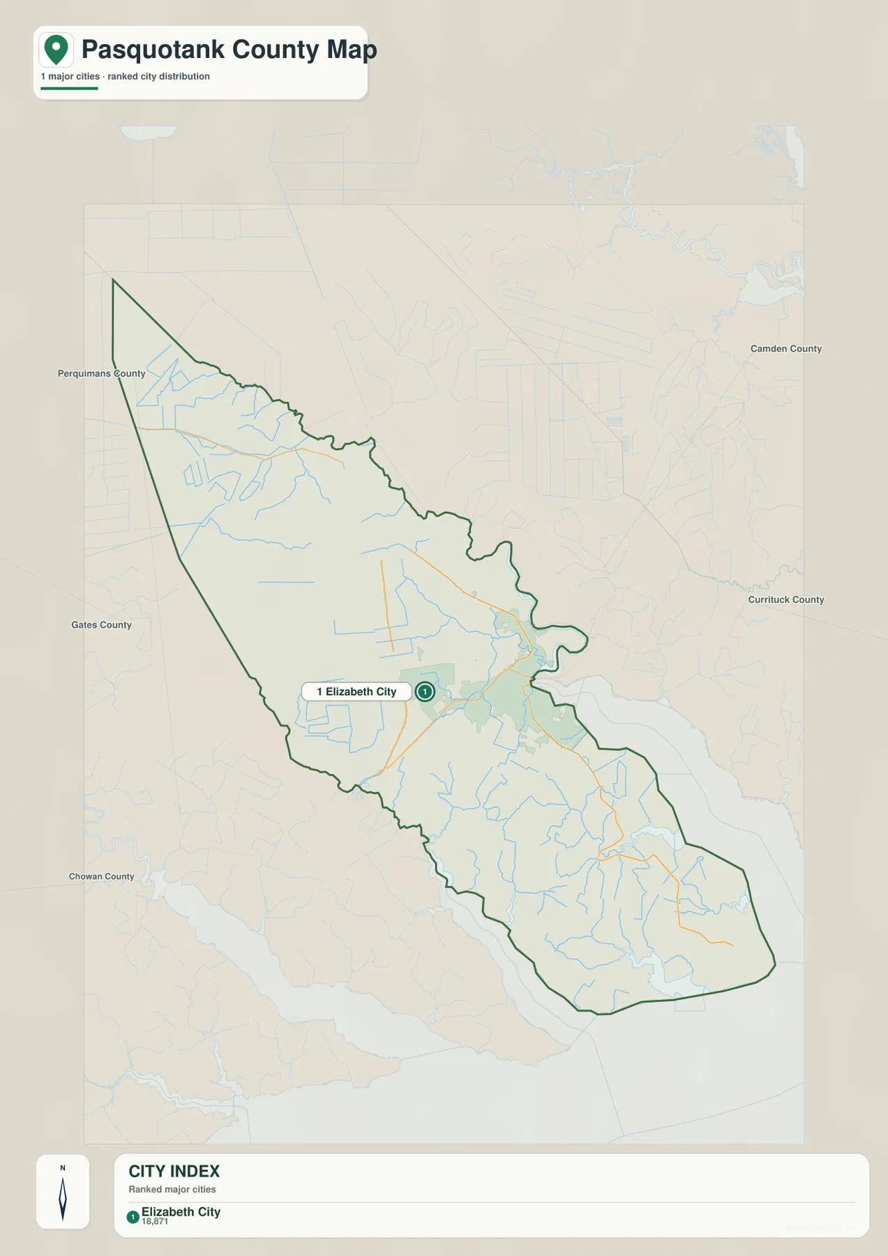
No connector distances or travel times are shown on this city map. It should therefore be used to locate the principal city within the county rather than to estimate mileage between places. For actual route orientation, return to the general map and compare Elizabeth City with US 17, US 158, NC 34, and the smaller surrounding labels.
The Pasquotank River and Albemarle Sound are only the largest parts of a much denser water network
The terrain-and-water map brings out details that are easy to miss behind the road network. Pasquotank River is labeled as one of the county’s major water references, and Albemarle Sound occupies the broad water area along the southern end. The existing page material also treats the river and sound as the main physical framework for understanding the county, which fits the new map: Elizabeth City sits within a landscape where larger water bodies and smaller tributaries are closely connected.
Many smaller waterways are named individually. Newland Drainage Canal appears in the north, while Knobbs Creek and Mill Dam Creek are visible nearer the central-eastern portion. Farther south, the map labels Little River, Halls Creek, New Begun Creek, Symonds Creek, Matthews Creek, Chapel Creek, and Little Flatty Creek. Their distribution shows why the southern half of the county cannot be understood from roads alone; a large number of narrow channels break up the low coastal landscape.
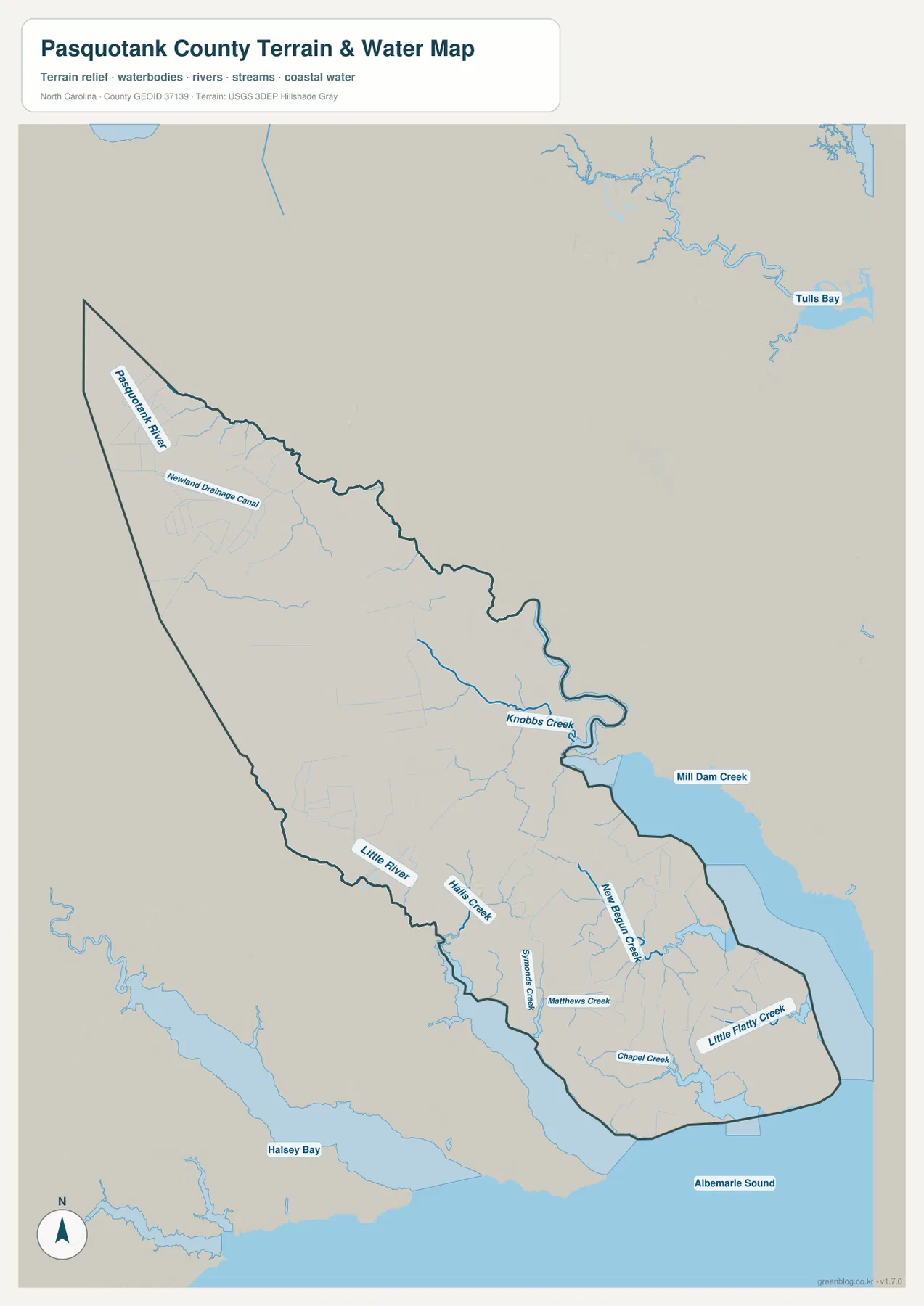
Halsey Bay and Tulls Bay are labeled outside the county and provide additional regional context. The shaded terrain is subdued because the supplied map does not show a mountainous landscape or large elevation contrasts. Instead, the most important physical differences come from the arrangement of rivers, creeks, bays, and sound water. That is why the water map is especially useful for explaining the southeastern part of the county, where the road map alone can make the land appear more continuous than it really is.
This is a general water-reference map, not a flood-hazard map, navigation chart, parcel map, or legal-boundary product. It is appropriate for identifying the approximate location of named waterways and for understanding the county at a broad geographic scale. Anyone who needs detailed hydrography or current technical water data should consult the USGS National Hydrography source linked in the reference section below.
From Lynch’s Corner to Glen Cove, the county changes noticeably from northwest to southeast
Pasquotank County’s long shape is easy to overlook if the map is viewed only around Elizabeth City. In the northwest, Lynch’s Corner and US 158 define a relatively simple upper section. US 17 then leads toward Elizabeth City, where roads and developed areas become denser. Beyond the city, Rabbit Corner, NC 34, and Glen Cove extend the map toward the southeast, where smaller roads and waterways become more prominent.
The water map reinforces that change. Newland Drainage Canal and several narrow channels appear in the northern part, Knobbs Creek is highlighted nearer the middle, and a much larger group of named creeks fills the southern portion. Little River, Halls Creek, New Begun Creek, Symonds Creek, Matthews Creek, Chapel Creek, and Little Flatty Creek all appear before the county reaches the Albemarle Sound edge. The result is a county that looks simple along some northern roads but increasingly intricate as the map approaches the sound.
The city map also places nearby county names around the outside, including Perquimans, Gates, Camden, Currituck, and Chowan. Those labels are useful for regional orientation, though the map should not be treated as a legal adjacency survey. Their main value is to show that Pasquotank sits within a closely divided northeastern North Carolina landscape where county lines, rivers, and sound water are never far apart.
Use the road map for routes and the water map for the county’s finer geographic detail
The general map is the strongest choice when you need Elizabeth City, the county boundary, and the main highways in one view. It lets you follow US 17, US 158, and NC 34 while keeping smaller references such as Lynch’s Corner, Rabbit Corner, and Glen Cove visible. The city map is much cleaner and is best when the only question is where the county’s principal ranked city sits.
The terrain-and-water map becomes more useful once the question shifts from roads to the physical landscape. It names creeks that are too small to dominate the road map and makes the relationship between the Pasquotank River, smaller channels, and Albemarle Sound much easier to see. Reading all three maps together gives Elizabeth City a clear urban context without letting the city hide the water-rich southern and southeastern parts of the county.
The downloadable ZIP contains three high-resolution A3 JPG files matching the general county map, city-distribution map, and terrain-and-water map shown in this article. These files are larger than the WebP previews and are intended for printing, enlarged inspection, and insertion into documents. They are general geographic references, so surveying, legal boundary decisions, flood determinations, and navigation should still rely on the appropriate official technical data.
Frequently Asked Questions
Why does the city map show only Elizabeth City?
The supplied city map ranks only one major city, Elizabeth City. Smaller place labels and road references are available on the general county map, so use that view when you need Lynch’s Corner, Rabbit Corner, Glen Cove, or the surrounding highway pattern.
What waterways are shown besides the Pasquotank River and Albemarle Sound?
The map labels Newland Drainage Canal, Knobbs Creek, Mill Dam Creek, Little River, Halls Creek, New Begun Creek, Symonds Creek, Matthews Creek, Chapel Creek, and Little Flatty Creek. These smaller waterways are especially useful for understanding the southern half of the county.
What files are included in the download ZIP?
The archive contains three high-resolution A3 JPG files corresponding to the general county map, city-distribution map, and terrain-and-water map. The WebP images in the article are previews, so the JPG files are preferable when you need to print or enlarge the maps.
Map File Information
The ZIP contains three high-resolution A3 JPG files matching the Pasquotank County map, city-distribution map, and terrain-and-water map shown on this page.
- Included Files: Use only the versions confirmed in the article and supplied images
- File Type: Use the confirmed download contents
- Intended Use: Printing, education, presentations, and map-based projects
Related Maps
Sources and References
These sources provide county background, boundary and road data, and hydrographic context. The maps on this page are designed as clear general-purpose geographic references, so readers who need current legal boundaries or detailed technical water information should also consult the original agency data.
Green Map creates custom-edited map images using open geographic data sources such as geoBoundaries, Natural Earth, OpenStreetMap, and government open data.
These maps are edited visual materials, not raw data files, and are provided for education, documents, presentations, and graphic reference.