Liberty County, Florida is easier to understand when Bristol and State Road 20 are used as the starting point. Bristol sits near the winding western edge of the county, Hosford lies farther east along the same cross-county route, and the map opens into a much larger forested interior to the south. The western boundary follows the Apalachicola River corridor, while streams and wetlands become increasingly important landmarks away from the northern settlements.
This page includes a county reference map, a city map, and a terrain-and-water map. You can inspect the WebP versions on the page and then download a ZIP containing three A3 high-resolution JPG map files from the file box below. The maps are useful for printing, classes, presentations, and general location reference, but they are not substitutes for legal boundary surveys, live road information, flood forecasts, or navigation charts.
Table of Contents
Start with Bristol, Hosford, and the Northern Road Network
Bristol is the county seat and the clearest orientation point on the general map. It appears in northwestern Liberty County close to the Apalachicola River side of the boundary. State Road 20 passes through the area, crossing west toward Blountstown and continuing east through Liberty County toward Hosford. Once those two place names are located, the county’s northern settlement pattern and the main east-west travel corridor become much easier to follow.
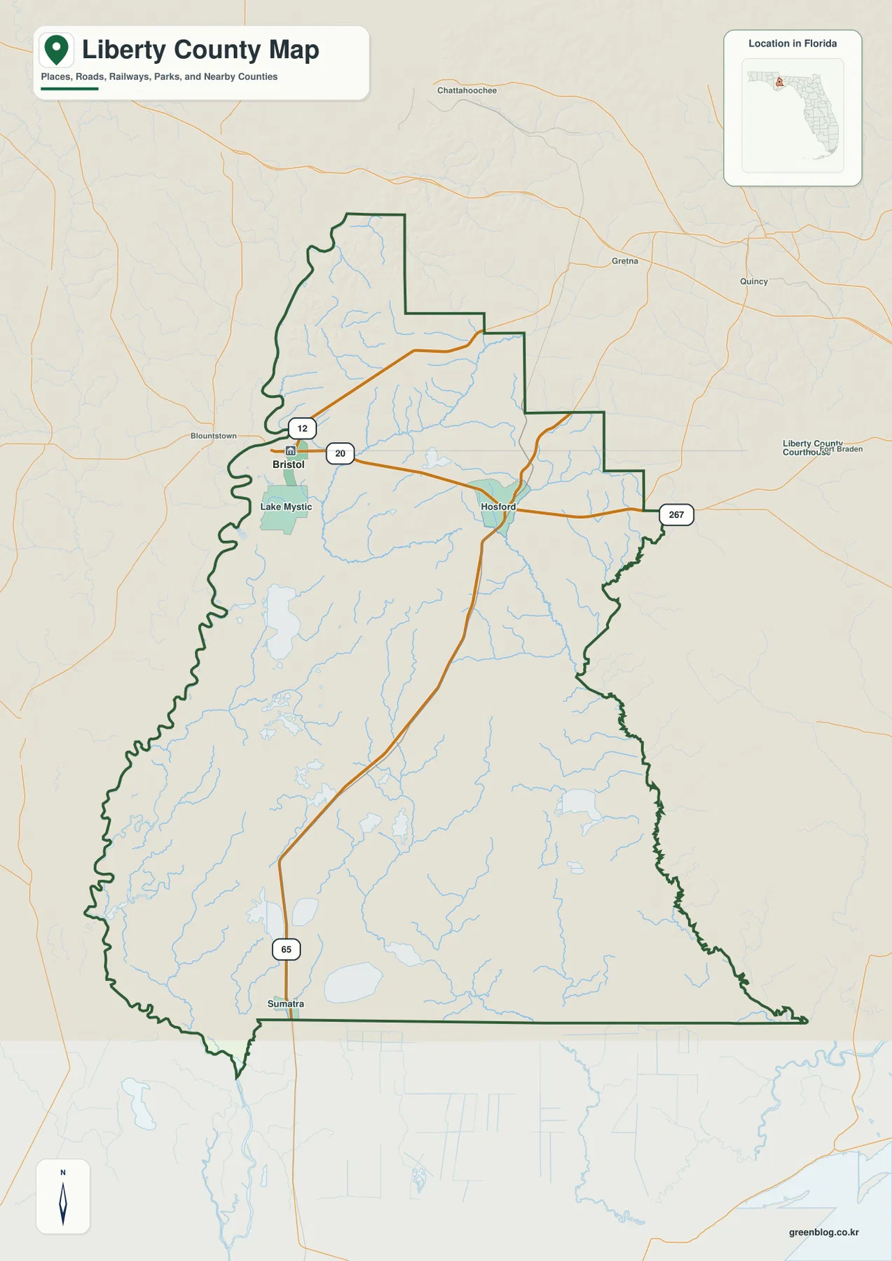
Several state highways branch from that northern corridor. SR 12 leaves the Bristol area toward the northeast, SR 65 turns south through the county, and SR 267 appears near the northeastern side. No Interstate or U.S. Highway crosses Liberty County itself on the supplied map, so these state roads carry most of the regional orientation. SR 65 is especially helpful for tracing the transition from the Hosford area toward Sumatra and the sparsely settled southern interior.
Lake Mystic is labeled just south of Bristol, adding another useful local reference close to the northern road system. Farther south, place labels become much less frequent. Sumatra stands out because it gives the lower part of the county a named reference point even where forest, wetlands, and small waterways occupy much more map space than towns or developed street grids.
Why the City Map Puts So Much Emphasis on Bristol
The city map is intentionally simple. Its ranked city index highlights Bristol as the single major city, rather than trying to treat every community label as the same type of place. That distinction matters in Liberty County: Bristol is an incorporated city and the county seat, while Hosford, Telogia, Lake Mystic, Estiffanulga, and Sumatra are unincorporated communities identified in county material. A reader can therefore use the city map for administrative context and return to the general map for the broader network of community names.
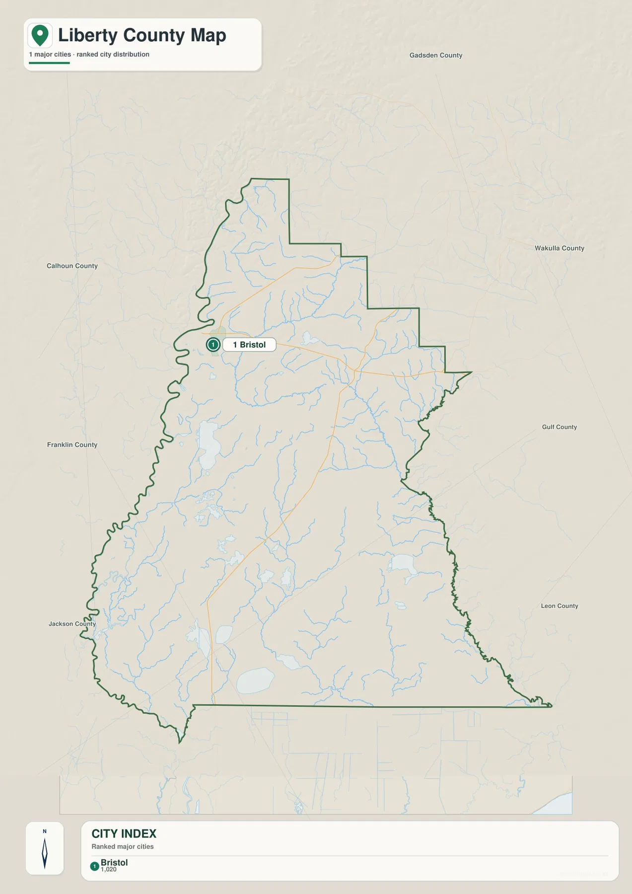
The surrounding labels are almost as useful as the city marker. Calhoun County is to the west, Gadsden is to the north and northeast, Wakulla and Leon appear to the east, and Franklin lies toward the south. Because Liberty County is long from north to south and has irregular river-influenced edges, this neighboring-county context prevents Bristol from being mistaken for a centrally located seat. It actually sits close to the western side of the county.
Hosford does not appear as a ranked major city on this map, yet it remains one of the most useful labels on the county reference map. It sits along SR 20 near the route that turns south on SR 65, so it works as a practical road-orientation point. Using Bristol for administrative location and Hosford for the road network gives a more complete picture than relying on either map alone.
Creeks, Rivers, and Bays Across the Forested Interior
The terrain-and-water map changes the emphasis from roads to drainage. On the west, the boundary follows the broad river corridor associated with the Apalachicola system rather than a straight surveyed line. In the southwest, labels such as Florida River, River Styx, and Kennedy Creek show how many smaller waters connect with the larger river-and-wetland landscape. This is one reason the western edge looks so irregular on the county map.
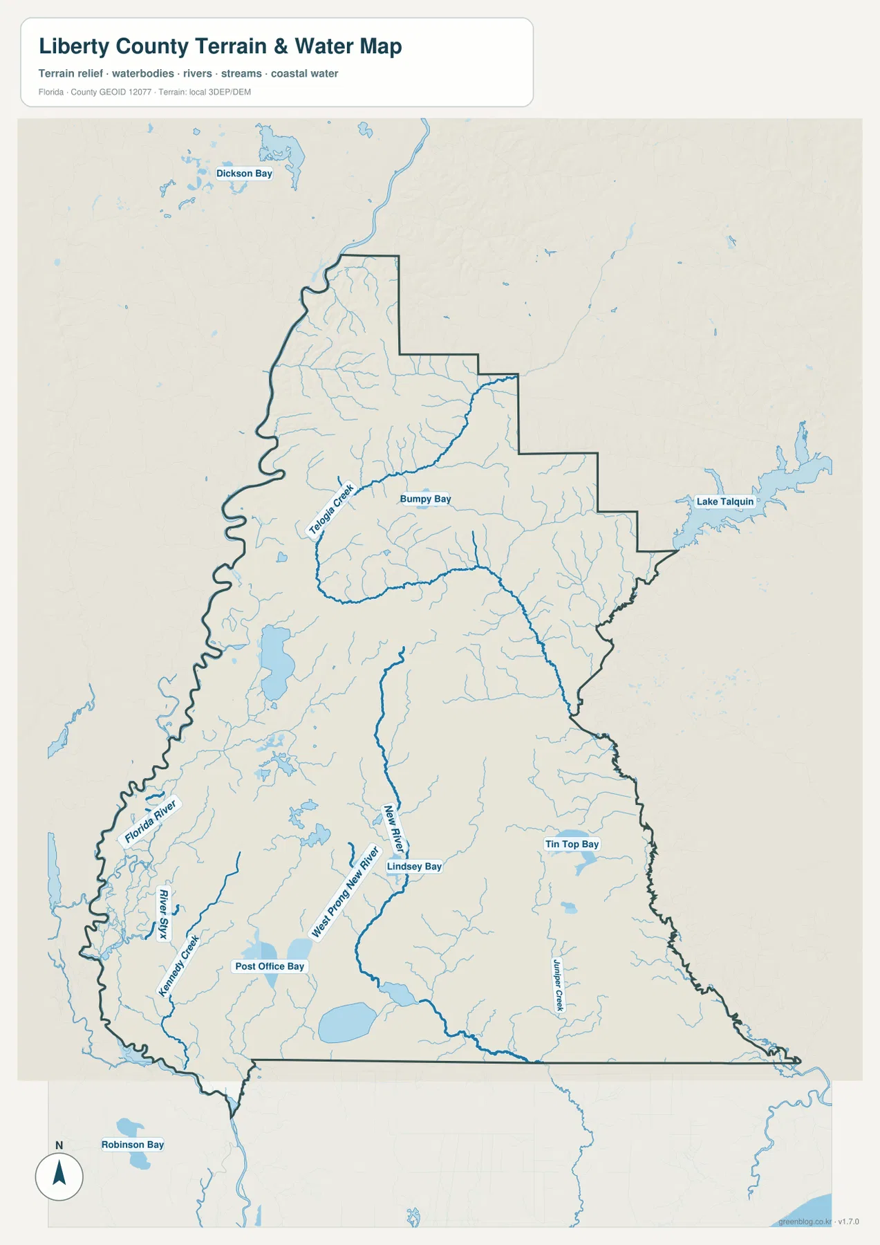
Telogia Creek is one of the strongest interior water labels in the north-central part of the map. Bumpy Bay appears nearby, and a network of smaller channels spreads across the same area. Farther south, New River and West Prong New River provide long north-south reference lines through land where major roads are scarce. Lindsey Bay, Post Office Bay, Tin Top Bay, and several smaller creeks add detail that does not appear on the simpler road-focused map.
The map also includes water features outside the county boundary to help with regional orientation. Lake Talquin appears to the northeast, Dickson Bay is shown beyond the northwestern side, and Robinson Bay is visible southwest of the county. Water does not stop at a county line, so including nearby features makes the drainage network easier to interpret. These labels should still be treated as location references rather than statements about flood depth, water level, boating access, or navigability.
South of the Northern Corridor, Forest Becomes the Main Map Feature
Much of southern Liberty County lies within Apalachicola National Forest. The supplied maps reflect that reality: south of the Bristol-Hosford area, town labels thin out, highways become widely spaced, and streams, swamps, and forest roads take on a larger role. Sumatra and SR 65 are therefore stronger orientation points than a dense street pattern. The open areas on the map should not be read as missing data or unused land; they correspond to extensive forest and wetland landscapes.
The northwestern Apalachicola River side adds a different landscape. Torreya State Park is known for high bluffs and ravines along the river and for the rare Florida torreya tree. That setting contrasts with the broader low forest and wetland areas farther south. Liberty County is therefore more varied than a quick glance at its low population density might suggest, with steep river-edge terrain in one area and large flat forest tracts in another.
Census figures in the supplied source material help explain the sparse appearance of the map. Liberty County had 7,974 residents in 2020 across 835.56 square miles of land, or about 9.5 residents per square mile. The practical result is visible on all three maps: community names are far apart, only a few state roads cross the interior, and natural features often provide better orientation than urban street networks.
Choosing the Best Map for a Liberty County Question
Use the general county map when the question involves Bristol, Hosford, Lake Mystic, Sumatra, surrounding counties, or the direction of SR 12, SR 20, SR 65, and SR 267. It keeps roads, boundary shape, place names, and major waterways in one view. The city map is better when you want a clean explanation of where Bristol sits within the county without the distraction of every small community and stream.
The water map becomes more useful when the focus shifts to Telogia Creek, New River, the western river corridor, or the many bays and tributaries in the southern half of the county. For a classroom or presentation, a simple sequence works well: locate Bristol and SR 20 on the general map, show the county’s north-south extent on the city map, and then use the water map to explain why the southern interior has fewer roads and more named waterways.
The downloadable archive contains the three maps shown on this page as A3 high-resolution JPG files. They can be enlarged beyond the web previews for printing, personal reference, study notes, or presentation graphics. If the maps are used for travel planning, always compare them with current road information, park access notices, and any other official source needed for the specific trip.
Frequently Asked Questions
Is Bristol or Hosford the county seat of Liberty County?
Bristol is the county seat. It is an incorporated city near the western side of northern Liberty County, while Hosford is an unincorporated community farther east along SR 20. Hosford is still an important map reference because it sits near the north-south SR 65 corridor.
Why are there so few town labels in southern Liberty County?
Large parts of the south are national forest, wetlands, and wilderness rather than incorporated development. Sumatra and SR 65 remain useful orientation points, but streams and forest features become more prominent than towns. The sparse labeling is consistent with the county’s low population density and the large amount of public forest land.
Which waterways are easiest to locate on the water map?
Telogia Creek is a strong reference in the northern interior, while New River and West Prong New River are easy to trace farther south. Nearby labels such as Bumpy Bay, Lindsey Bay, Post Office Bay, and Tin Top Bay help break the forested interior into smaller recognizable areas.
Map File Information
Download the Liberty County county map, city map, and terrain-and-water map as A3 high-resolution JPG files.
- Included Files: 3 A3 JPG maps
Related Maps
Sources
- U.S. Census Bureau – Liberty County QuickFacts
- Liberty County government – About Us
- City of Bristol – City Info
- Florida Department of Transportation – County General Highway Maps
- U.S. Forest Service – Apalachicola National Forest
- Florida State Parks – Torreya State Park
Green Map creates custom-edited map images using open geographic data sources such as geoBoundaries, Natural Earth, OpenStreetMap, and government open data. These maps are edited visual materials, not raw data files, and are provided for education, documents, presentations, and graphic reference.