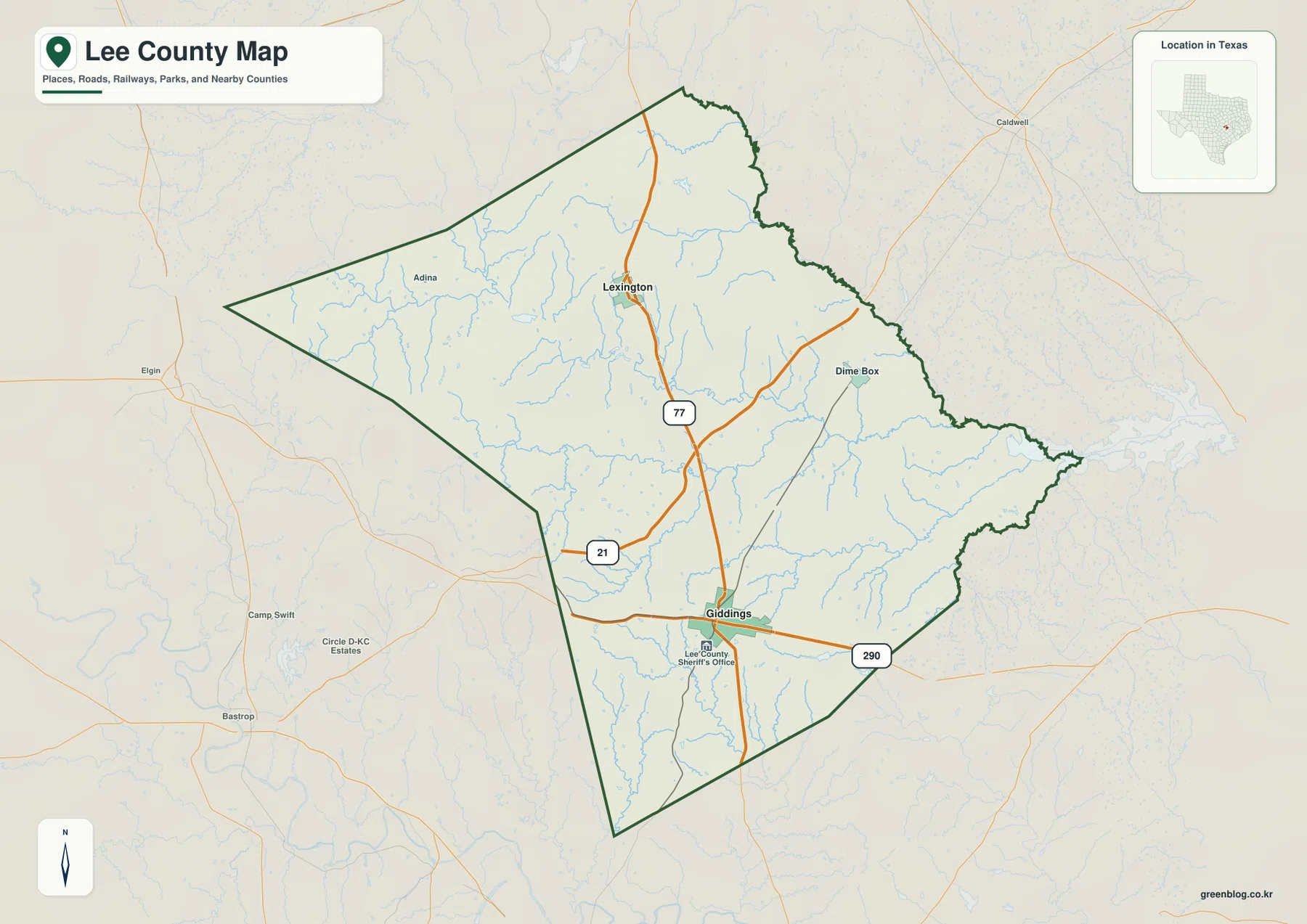
You can download four high-resolution A3 JPG maps of Lee County, Texas, in one ZIP directly from this page. The set includes a general county map, a ranked city map, a terrain-and-water map, and an elevation map. Together they show Giddings, Lexington, Dime Box, Adina, roads marked 77, 21, and 290, the West and Middle Yegua Creek systems, several named lakes, and an actual elevation range of about 72 to 226 meters.
Giddings and Lexington make the easiest pair of reference points. Giddings lies in the southern part of the county where routes 77 and 290 meet, while Lexington is farther north on the same north-south corridor. Route 21 enters from the west and meets the central road network between the two towns. Once those lines are clear, Dime Box to the northeast and Adina to the northwest are much easier to place, and the water and elevation maps can be compared against the same county outline.
Table of Contents
Giddings and Lexington provide the clearest north-south reference
Giddings is the most prominent settlement label on the general map. It sits near the southern part of Lee County, close to the intersection of the roads marked 77 and 290. Route 290 runs east-west through the Giddings area, while 77 continues north through the center of the county toward Lexington. The Lee County Sheriff’s Office label appears just below Giddings and serves as another visible landmark for locating the town on the map.
Lexington is positioned in the north-central area along Route 77. Between Giddings and Lexington, Route 21 enters from the west and meets the main north-south road. Dime Box sits farther to the northeast, connected by an eastward road from the central corridor, while Adina is labeled in the broad northwestern part of the county. These places are spread far enough apart that road lines are more useful than town names alone for judging their relative positions.
The county outline is broad and pointed on the west and becomes narrower and more irregular toward the east. Thin blue stream lines cross nearly every part of the interior. The general map is therefore best for combining settlement and road information, while the water map later on the page is better for identifying the names of the streams and lakes behind those blue lines.
The city index reduces the map to Giddings and Lexington
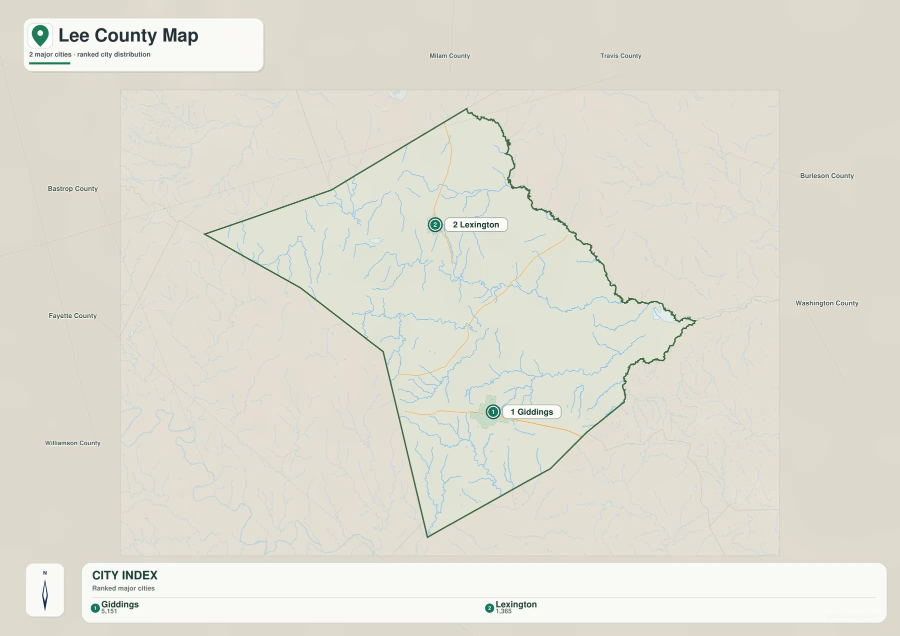
The ranked city map labels two major cities: Giddings as number 1 and Lexington as number 2. Giddings is near the southern side of the county and Lexington is well to the north, so the simplified view makes their separation especially easy to see. Dime Box and Adina, which are visible on the general map, are not part of this two-city ranking.
Names around the outside include Bastrop, Fayette, Williamson, Milam, Travis, Burleson, and Washington counties. They are useful as surrounding regional labels, but the map should not be read as saying that every county name shown around the frame necessarily shares a direct boundary with Lee County. The key information in this view is the relative position of the two ranked cities inside the county.
For a presentation or simple locator graphic, the city index is cleaner than the detailed road map. When the question involves Route 21, Route 290, Dime Box, or other local features, the general map is the better reference. Since both views use the same outline and orientation, it is easy to move back and forth without losing the location of Giddings or Lexington.
West and Middle Yegua Creek organize much of the water map
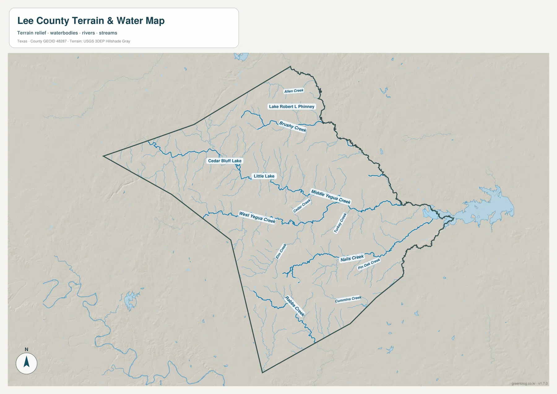
The terrain-and-water map gives much more detail to the drainage network. West Yegua Creek is one of the longest labeled waterways, crossing from the western side toward the center. Middle Yegua Creek runs through the central-eastern part of the county. Cedar Creek and Turkey Creek are labeled between and around these larger channels, creating several named reference points in the middle of the map.
The northern area contains a different group of features. Brushy Creek and Allen Creek are clearly labeled, along with Lake Robert L. Phinney. Cedar Bluff Lake lies farther west and slightly south, with Little Lake nearby. Those lake names give the northern part of the county several compact landmarks that contrast with the longer creek channels crossing the middle and south.
In the southern half, the map labels Elm Creek, Nails Creek, Pin Oak Creek, Rabbs Creek, and Cummins Creek. Nails Creek is especially prominent across the southeastern interior, and Pin Oak Creek lies nearby. The map is intended to show the relative position of water features; it should not be treated as a flood-risk product, a legal water-boundary map, or a navigation chart.
Higher western terrain falls toward lower eastern valleys
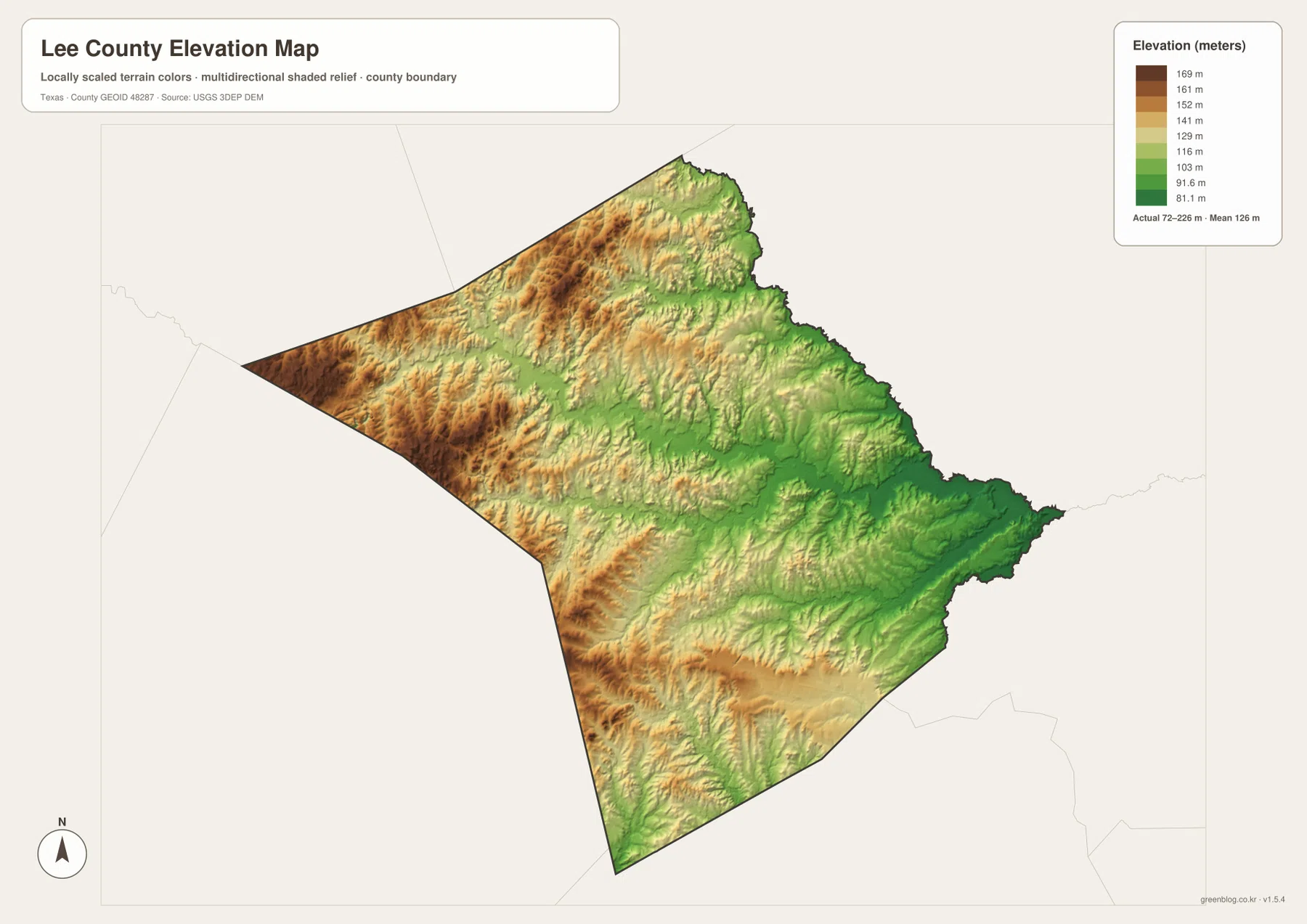
The elevation map reports an actual range of about 72 to 226 meters and a mean elevation of about 126 meters. Browns and tans are concentrated across much of the west and northwest, where the county is higher. Greens spread more widely through the center and east, with the lowest colors becoming prominent near the eastern and southeastern edges.
The drainage map helps explain the branching relief. Lower green corridors follow West Yegua Creek, Middle Yegua Creek, and many of their tributaries. Even the higher western side is not a single flat block; repeated ridges and narrow valleys create a textured surface. The eastern side has broader low areas, with creek valleys merging into a generally lower landscape.
The difference between the displayed minimum and maximum is about 154 meters. That is enough to make local relief easy to see even though Lee County is not a high mountain county. This image is best used for comparing relative elevation and the relationship between terrain and streams, rather than as survey-grade or engineering-grade elevation measurement.
Road, water, and elevation views become clearer when matched by location
The Giddings-to-Lexington corridor is a useful example. On the general map, Route 77 provides a simple north-south line between the two towns. On the water map, West Yegua Creek and Middle Yegua Creek cross the central part of the county near that same corridor. The elevation view then shows lower valleys following the drainage network through the surrounding higher ground.
Dime Box offers another comparison. The road map places it in the northeastern part of Lee County on an eastward branch from the central corridor. The water map shows Middle Yegua Creek and smaller tributaries in the same broad area, while the elevation map becomes greener toward the east. Reading the three views together gives a more concrete picture of the county than treating roads and terrain as unrelated layers.
Use the ranked city map when only Giddings and Lexington need to be placed. Use the general map for roads and additional settlement labels, the terrain-and-water map for creek and lake names, and the elevation map for the higher-west/lower-east contrast. Smaller names can be easier to inspect in the downloadable high-resolution files than in the web previews.
Frequently Asked Questions
What is the easiest way to locate Giddings and Lexington?
Find Route 77 on the general map. Giddings is in the southern part of the county where Route 290 crosses the corridor, and Lexington is farther north along the same road. The ranked city map makes the separation even clearer by showing only these two major cities.
Which named water features stand out on the map?
West Yegua Creek and Middle Yegua Creek are the main central references. The northern area also labels Brushy Creek, Lake Robert L. Phinney, Cedar Bluff Lake, and Little Lake, while Nails Creek, Pin Oak Creek, Rabbs Creek, and Cummins Creek are visible farther south.
What elevation range does the Lee County Texas map show?
The supplied elevation map reports an actual range of about 72 to 226 meters and a mean of about 126 meters. Higher terrain is concentrated in the west and northwest, while lower valleys and broader green areas become more common toward the east and southeast.
Sources and Reference Data
- U.S. Census Bureau TIGER/Line Shapefiles — official county-boundary and road geometry for geographic reference.
- USGS National Hydrography — official resources for creeks, lakes, and other water features.
- USGS 3D Elevation Program — official elevation resources used for terrain information.
- USGS The National Map Viewer — an official viewer for comparing multiple geographic layers.
Map File Information
Download four high-resolution A3 JPG maps of Lee County, Texas, in one ZIP file.
- Included Files: county map, ranked city map, terrain and water map, elevation map
- File Type: JPG
Related Maps
- Bastrop County Texas map
- Washington County Texas map
- Robertson County Texas map
- Austin County Texas map
- Williamson County Texas map
Green Map creates custom-edited map images using open geographic data sources such as geoBoundaries, Natural Earth, OpenStreetMap, and government open data.
These maps are edited visual materials, not raw data files, and are provided for education, documents, presentations, and graphic reference.