Cumberland County is easiest to understand when Fayetteville is treated as the main urban reference rather than the whole story. The county map shows a dense road network around Fayetteville, Hope Mills to the south, Spring Lake to the northwest, and a string of smaller places extending east and northeast. The Cape Fear River provides a second organizing feature because it crosses the county near the urban core and continues toward the southeast. This page includes a general county map, a ranked city map, and a terrain-and-water map, and the high-resolution JPG versions can be downloaded together from the map file box below.
The three views are useful for different questions. The county map is best for roads, boundaries, place names, and landmarks; the city map strips the scene down to the six highlighted population centers; and the water map brings rivers, creeks, ponds, and subtle relief into the foreground. Reading them together makes it much easier to see why Fayetteville dominates the center without erasing the distinct positions of Hope Mills, Spring Lake, Eastover, Stedman, Wade, and the communities farther northeast.
Table of Contents
Fayetteville gives the county its clearest urban reference
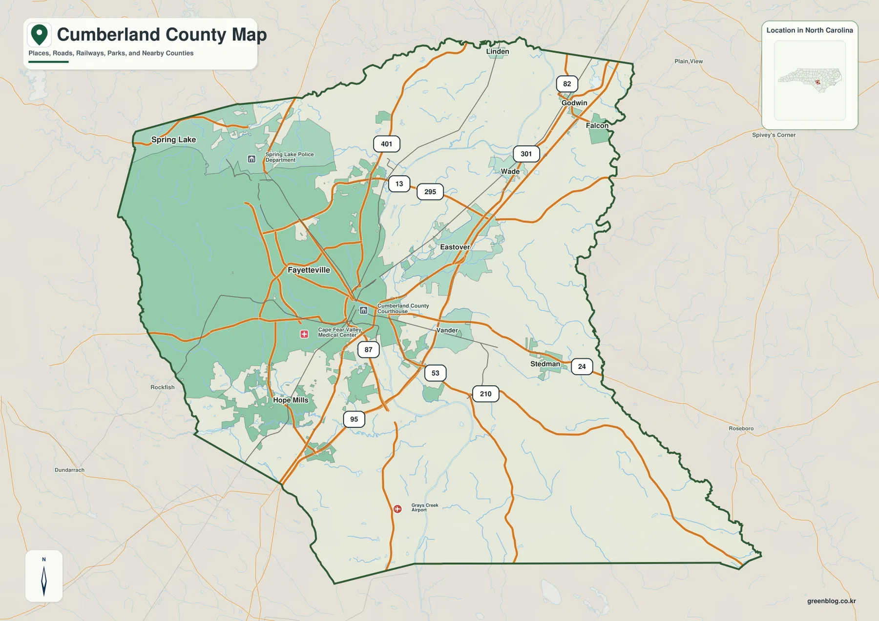
On the general map, Fayetteville sits slightly west of the county’s center and is surrounded by the most complex concentration of roads. The Cumberland County Courthouse appears near the central urban area, while Cape Fear Valley Medical Center is marked farther southwest. Those landmarks make the map useful even before smaller street-level detail is added: they show where the county’s administrative and service center lies in relation to the wider outline. Hope Mills sits south of Fayetteville, and Spring Lake is separated from it to the northwest, giving the county more than one obvious suburban direction.
Eastover and Vander appear on the eastern side of the Fayetteville area. Stedman lies farther east and slightly south, while Wade is northeast of the central city. The general map also marks Linden, Godwin, and Falcon near the northern and northeastern portion of the county. These labels matter because they prevent the county from looking like a single metropolitan blob. Fayetteville is clearly the largest reference point, but smaller communities help define the distance between the urban core and the county line.
The surrounding county names provide a second layer of orientation. Harnett, Moore, Sampson, Johnston, Bladen, Robeson, and Hoke are labeled around Cumberland on the city view. They are most useful as regional reference points rather than as a claim that every label shares the same kind or length of border with Cumberland. By keeping the dark county outline in view, a reader can tell where Cumberland ends while still seeing the larger part of south-central North Carolina in which it sits.
Major roads fan out from Fayetteville in several directions
I-95 is the easiest highway to pick out. It enters the county from the south, passes east of central Fayetteville, and continues northeast through the Wade-Godwin side of the map. Route 295 forms another prominent connection around the northern and eastern side of the urban area. Routes 401 and 301 provide additional north-south references, while 87 is especially useful for following the southern side of Fayetteville toward Hope Mills and the lower part of the county.
The road pattern becomes more informative when the route numbers are tied to specific places. Stedman sits along the eastern side near Route 24, and Route 53 also runs eastward from the Fayetteville area. Route 210 reaches toward the southeastern half of the county, while Route 82 appears in the northeast near Godwin and Falcon. Route 13 crosses the north-central portion of the urban area and meets the broader network around 295. Instead of memorizing each number, it is usually faster to use Fayetteville as the starting point and follow the road leading toward the community you need.
Grays Creek Airport is marked south of Fayetteville and provides a useful landmark in the large southern section where settlements are less visually dominant. This contrast is one reason the general map works well for orientation: the urban center has many roads and labels, while the outer county has longer stretches between major reference points. For actual driving, construction detours, or turn-by-turn navigation, a current road service should still be used because this map is designed as a county reference rather than a live traffic map.
Hope Mills, Spring Lake, and the smaller eastern places show the county’s spread
The ranked city map reduces the number of labels and makes the settlement pattern clearer. Fayetteville is shown as the first and largest center. Hope Mills is second and sits south of Fayetteville, while Spring Lake is third and lies to the northwest. Eastover is fourth on the eastern side of the central urban area, Stedman is fifth farther to the east-southeast, and Wade is sixth to the northeast. The ranking is useful, but the locations are more important for reading the map because the six places point in several different directions from the county’s main city.
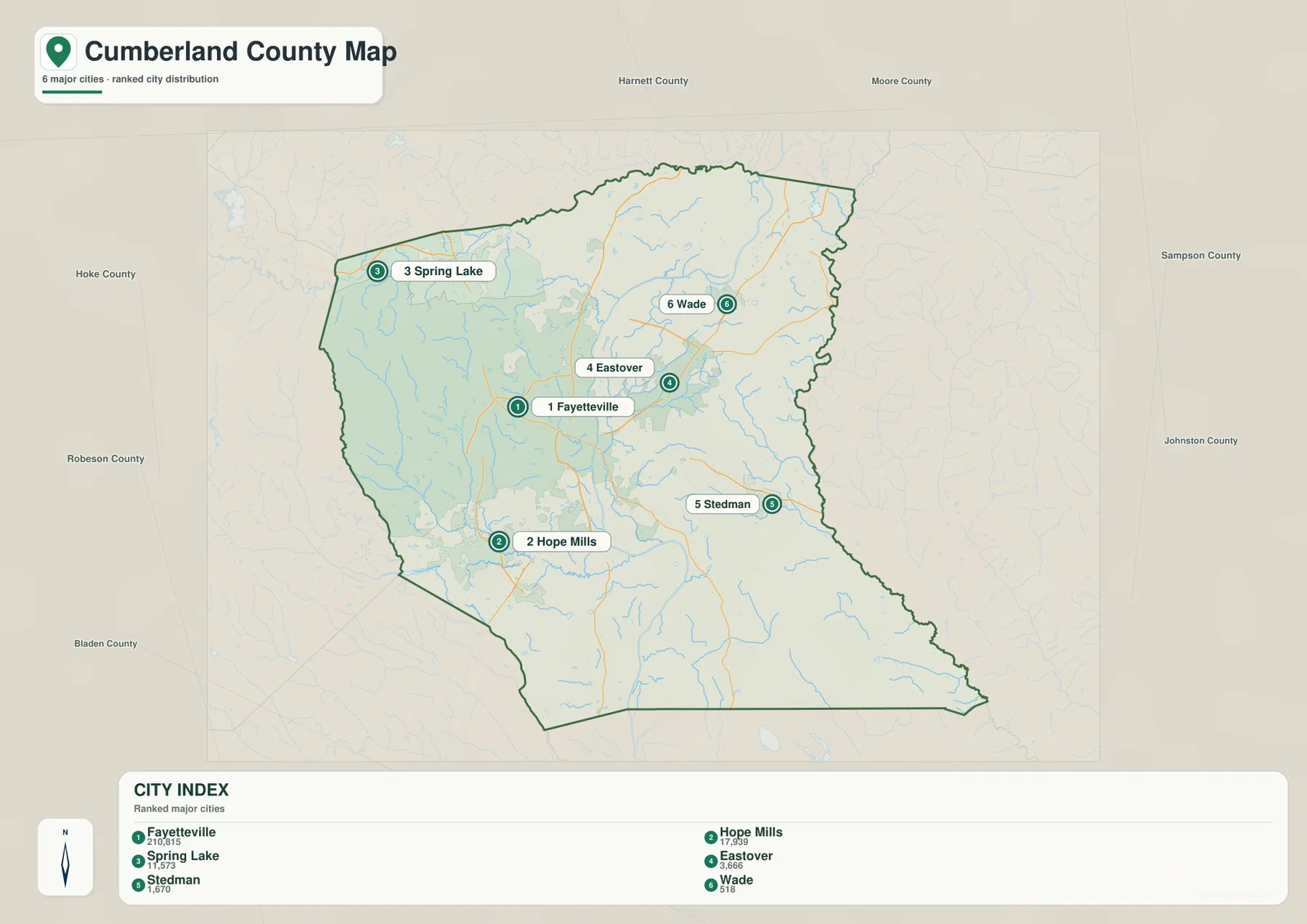
Hope Mills and Spring Lake are especially helpful because they sit on opposite sides of Fayetteville. Hope Mills extends the settled area southward, close to the lakes and creeks shown on the water map. Spring Lake gives the northwest a separate urban reference beside a large mapped tract west of the central city. Eastover, Stedman, and Wade then fill in the eastern half, showing that the county’s smaller communities are not clustered in one pocket.
This version is a better choice than the general county map when the main question is simply where the principal communities are relative to one another. It removes many secondary labels and lets the county outline, city markers, and surrounding counties carry the explanation. For a presentation or a regional comparison, that simplicity can be more useful than the richer road-and-landmark map, especially when the goal is to distinguish northwest Spring Lake from south Hope Mills or east Stedman.
The Cape Fear River organizes the water map
The terrain-and-water map has one feature that immediately stands above the rest: the Cape Fear River. It runs through the central part of Cumberland County and continues toward the southeast, providing a natural reference that can be compared with the urban pattern on the other maps. The Little River is labeled across the northern portion, while the South River follows the southeastern side. Those three rivers establish a broad framework before any of the smaller creeks are considered.
The southwest contains a denser group of named water features. Beaver Creek, Little Rockfish Creek, and Rockfish Creek appear close to one another, and Hope Mills Lake is positioned among that network. Lake Rim, Beaver Creek Pond, and Wallace Pond add smaller standing-water references nearby. Farther north and northeast, the map labels other ponds such as Rhodes Pond. The result is not a county with one isolated river; it is a landscape in which a major river, tributary creeks, lakes, and ponds appear throughout the county.
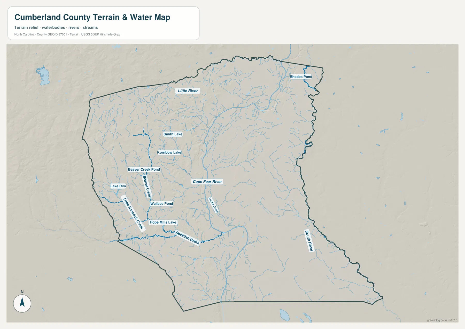
A useful way to read this map is to begin with the widest named rivers, then work inward to the local creeks. The Cape Fear River establishes the central and southeastern direction. The Little River gives the north a separate reference, and the South River helps define the lower eastern side. After those are located, the Rockfish Creek group around Hope Mills is much easier to place. This approach avoids treating every blue line as equally important and makes a dense hydrographic map much easier to use.
Gentle relief makes the drainage network more noticeable
The source material places Cumberland County in North Carolina’s western Coastal Plain. The shaded relief on the water map looks comparatively gentle: there are no dramatic mountain ridges or deep, tightly cut valleys. Instead, small changes in elevation appear beneath a dense drainage network. That matters for understanding the map because the creeks and rivers are more visually useful than a search for large peaks or mountain chains that are not present in this package.
The southwest around Hope Mills contains several closely spaced waterways and small lakes, while the north has many fine tributaries leading toward the Little River. The Cape Fear River remains the larger central reference, and the South River stands out near the southeast. The shaded terrain helps separate low ridges and shallow drainage areas, but it does not provide a numeric elevation scale. For that reason, the map supports relative terrain reading—where the surface rises and falls gently—not exact statements about a specific property’s elevation.
The same caution applies to water-related decisions. This is a county-scale reference map, not a live flood map, parcel survey, or regulatory wetland map. It can show that a road or community lies near a river, creek, pond, or low drainage area, but it should not be used by itself to decide whether a home is inside a flood zone or whether a particular parcel has a legal water boundary. Those questions require the appropriate current government or property-level source.
Choose the map that matches the question
Use the general county map when you need the broadest combination of information. It is the best place to compare Fayetteville with Hope Mills, Spring Lake, Eastover, Stedman, Wade, and the smaller northern communities while keeping I-95 and the numbered road network visible. It also shows landmarks such as the county courthouse, the medical center, and Grays Creek Airport, so it works well for a county overview or for explaining how an outer community relates to the central city.
Use the city map when the settlement pattern matters more than road detail. The six ranked places are easy to compare, and the surrounding county labels help with regional orientation. Choose the terrain-and-water map when the Cape Fear River, the Little and South rivers, the Rockfish Creek system, Hope Mills Lake, or smaller ponds are the focus. Because the shaded relief sits behind the water network, this third view is also the best of the supplied maps for describing Cumberland County’s gentle terrain without inventing exact elevation values.
These maps complement each other rather than compete for a single “best” choice. A student may use the general map for a county report, switch to the city map for a settlement comparison, and then use the water map to explain why the Cape Fear River is an important physical reference. A local-history or travel article can follow the same sequence. When a larger image is needed for printing or document layout, the downloadable ZIP contains the high-resolution JPG versions rather than only the smaller web previews shown on this page.
Frequently Asked Questions
How do Fayetteville and Hope Mills differ on the Cumberland County maps?
Fayetteville is the dominant central city and is surrounded by the county’s densest road network. Hope Mills is south of Fayetteville and closer to the cluster of southwestern water features, including Hope Mills Lake and the Rockfish Creek system. Looking at the general and city maps together makes that north-south relationship clear without treating the two places as a single point.
Why is the Cape Fear River a useful reference on this map?
The Cape Fear River is the most prominent named waterway running through the central part of the county and toward the southeast. Once it is located, the Little River to the north, the South River near the southeastern side, and the Rockfish Creek group in the southwest are easier to place. It also provides a natural feature that can be compared with Fayetteville’s road-centered urban pattern.
What is included in the Cumberland County map download?
The ZIP contains three high-resolution JPG files: the general county map, the ranked city map, and the terrain-and-water map. The WebP images in the article are intended for fast on-page viewing, while the JPG files are the better choice when you need a larger image for printing, documents, or offline reference.
Map File Information
The download includes high-resolution A3 JPG versions of the Cumberland County general map, city map, and terrain-and-water map. Use the ZIP when you need larger files than the web previews shown in the article.
- Included Files: Three high-resolution A3 JPG maps: general county map, ranked city map, and terrain-and-water map
- File Type: High-resolution A3 JPG files in one ZIP archive
- Intended Use: Printing, education, presentations, and map-based projects
Related Maps
Sources and References
- NCpedia – Cumberland County
- U.S. Census Bureau TIGER/Line Shapefiles
- USGS National Hydrography
- USGS 3D Elevation Program
Green Map creates custom-edited map images using open geographic data sources such as geoBoundaries, Natural Earth, OpenStreetMap, and government open data.
These maps are edited visual materials, not raw data files, and are provided for education, documents, presentations, and graphic reference.