Craven County is easier to understand when New Bern is treated as both a road reference and a river reference. The city sits beside the broad Neuse River where the Trent River approaches from the southwest, while Havelock lies well to the southeast along US 70 and Vanceboro marks the inland northwest. This page provides a county map for roads and boundaries, a city map that compares the main mapped communities, and a terrain-and-water map focused on rivers, creeks, and gentle relief. High-resolution JPG versions of the same map subjects are available together in the download ZIP near the end of the page.
The county has a stretched, irregular shape rather than a compact rectangular outline. New Bern and several nearby communities occupy the central part of that shape, but the county extends northwest toward Vanceboro and Cove City and southeast toward Havelock and Cherry Branch. The surrounding labels also help with orientation: Beaufort and Pitt counties are shown to the north, Lenoir and Jones to the west, Onslow to the southwest, and Pamlico and Carteret to the east and southeast. Those outer references matter because the county narrows around the Neuse River before extending again toward Havelock.
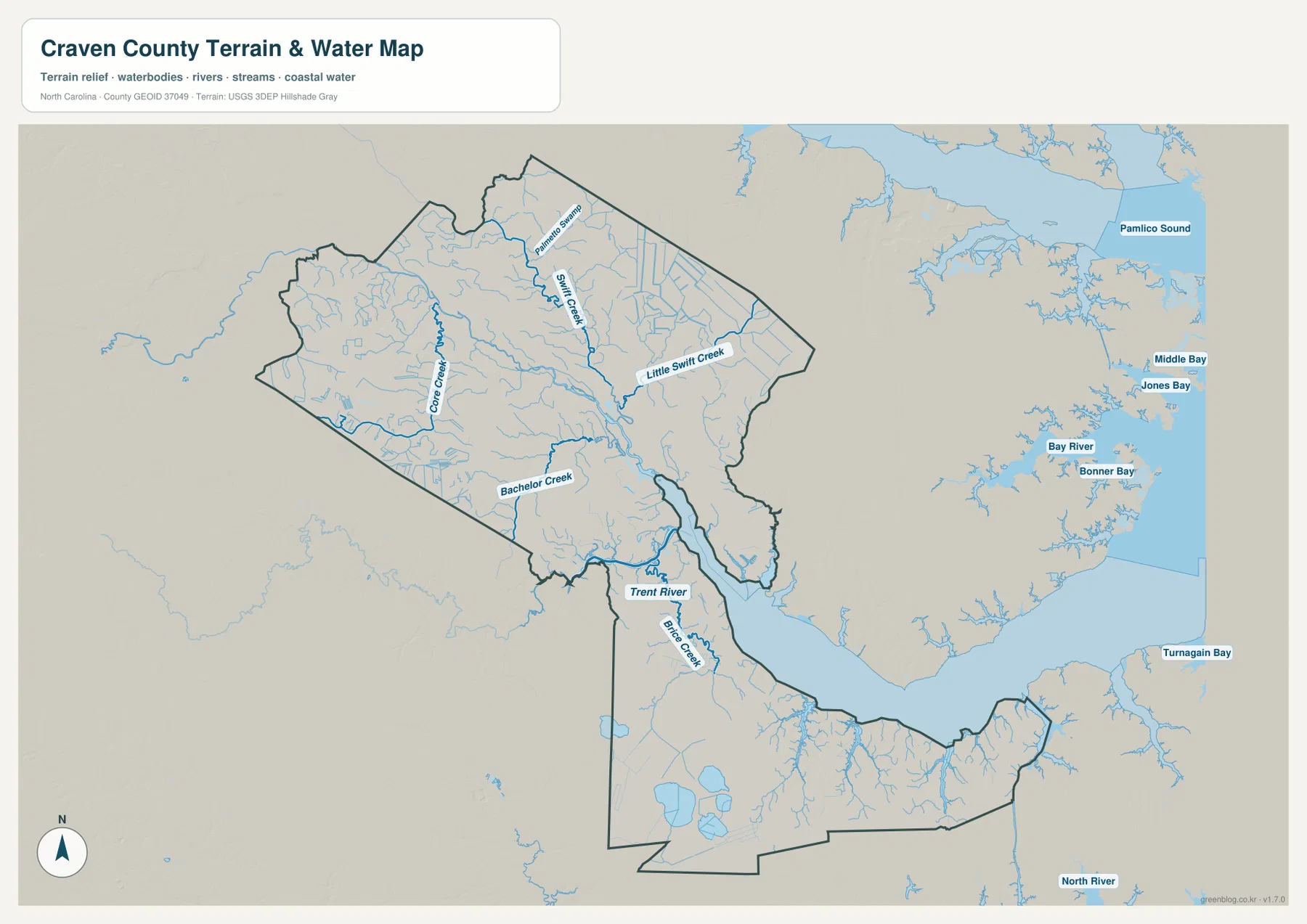
Water is just as important as the road network here. The map package shows the Neuse River and Trent River around New Bern, along with Swift Creek, Little Swift Creek, Core Creek, Bachelor Creek, Brice Creek, and other smaller channels. There is no separate elevation map or contour layer in this package, so the shaded background should not be used to assign precise elevations. It is best read as a broad terrain backdrop that helps place the waterways in a generally low-relief landscape.
Table of Contents
New Bern as the road junction between the northwest and Havelock
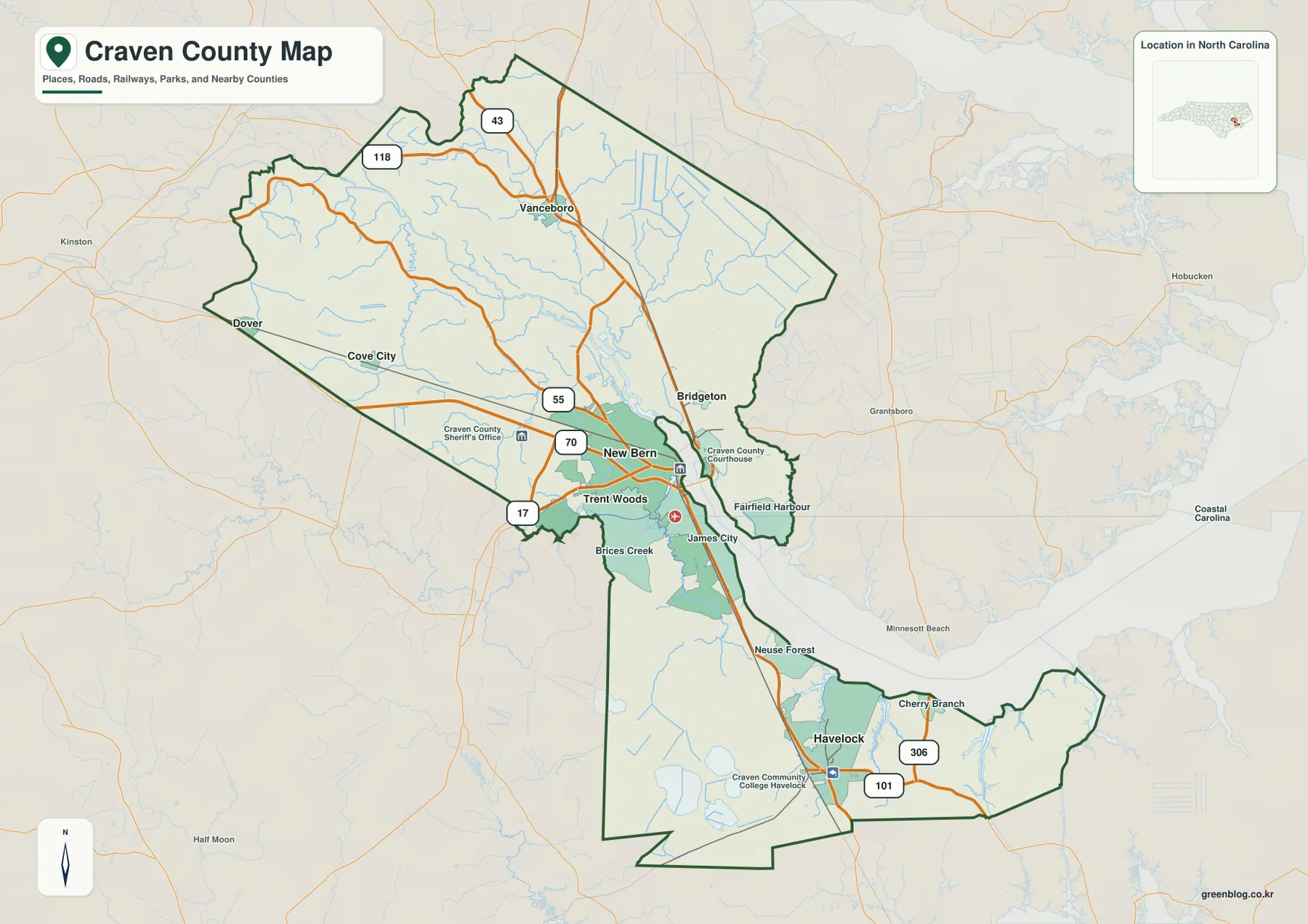
On the county map, New Bern is the clearest starting point because several important routes converge in or near the city. US 70 approaches from the west and continues southeast toward Havelock, giving the county a strong central-to-southeastern travel line. US 17 is also marked near New Bern before heading toward the southwestern side of the county. Farther northwest, NC 55 runs toward Cove City, while NC 43 and NC 118 appear around the Vanceboro side of the map. These roads make it easy to separate the inland northwest from the New Bern area without relying on county shape alone.
The southeastern section has its own set of reference points. Havelock sits directly on the US 70 corridor and is shown near the Craven Community College Havelock label. NC 101 branches toward the southeast, while NC 306 appears closer to Cherry Branch. This makes Havelock visually distinct from the communities clustered around New Bern. Someone looking only at the county seat could easily miss how far the county continues toward Carteret County and the lower-right edge of the map.
New Bern itself is surrounded by smaller place names that are useful when a map needs more local context. Trent Woods and River Bend lie on the southwestern side of the New Bern area, James City is just to the southeast, Bridgeton is across the water to the northeast, and Fairfield Harbour lies farther east. The basic county map is especially useful for this level of orientation because it keeps road numbers, county boundaries, waterways, and nearby communities visible at the same time. It is not a turn-by-turn navigation map, but it gives a reliable county-scale picture of which direction each place lies from New Bern.
Six mapped communities show how settlement is divided across the county
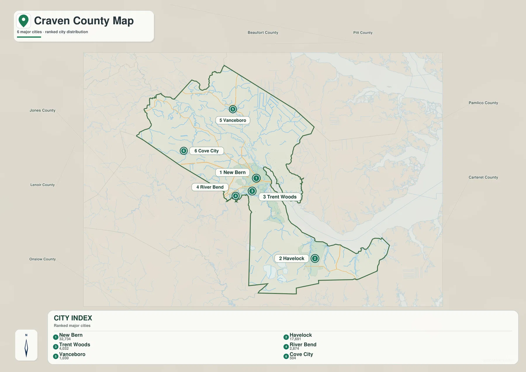
The city map reduces the number of labels and highlights six communities: New Bern, Havelock, Trent Woods, River Bend, Vanceboro, and Cove City. The values printed in the map index are 32,734 for New Bern, 17,691 for Havelock, 4,032 for Trent Woods, 2,874 for River Bend, 1,030 for Vanceboro, and 504 for Cove City. These figures are best treated as values printed on the supplied map rather than as a substitute for the latest official population table. Their main purpose here is to explain the ranking and relative prominence used by the city map.
The positions are more useful than the ranking alone. New Bern occupies the middle of the mapped county and forms a tight cluster with Trent Woods and River Bend. Havelock is clearly separated to the southeast, while Vanceboro and Cove City sit well to the northwest. That three-part arrangement—northwestern communities, the New Bern cluster, and Havelock—makes the county easier to remember than a simple list of town names. It also explains why a map centered only on New Bern cannot represent the full length of Craven County.
For practical map reading, start with the city map when you only need to decide which part of the county contains a place. If the destination is Vanceboro or Cove City, the next step is to use the county map and follow the northwest road network. If it is Havelock, US 70 provides the most obvious connection from New Bern. Trent Woods and River Bend are close enough to New Bern that the simplified city map helps separate their labels before the more detailed county map is used for roads and waterways.
The Neuse–Trent junction and the smaller creeks of inland Craven County
The terrain-and-water map changes the emphasis completely. The broad Neuse River dominates the central and eastern part of the county, and the Trent River enters the New Bern area from the southwest. This is why New Bern works so well as a physical reference point: it is not simply a centrally placed city label, but a location tied to a conspicuous meeting of waterways. When the county map and water map are viewed together, the positions of New Bern, Bridgeton, James City, and Fairfield Harbour make more sense because each sits close to this broad river environment.
The northwestern part of the county has a finer network of named streams. Palmetto Swamp is labeled near the north, Swift Creek and Little Swift Creek run through the northern and northeastern interior, and Core Creek and Bachelor Creek appear farther west and southwest. These features are much smaller than the Neuse River, but they keep the inland half of the map from reading as empty space. They also provide useful natural references around the Vanceboro and Cove City side of the county, where the settlement labels are more widely spaced.
South of New Bern, Brice Creek is clearly labeled and feeds into the larger river setting near the central part of the county. Smaller channels continue toward the Havelock section. The map also shows named coastal waters outside the Craven County boundary to the east, including Pamlico Sound, Middle Bay, Jones Bay, Bay River, Bonner Bay, and Turnagain Bay. Those outside labels are useful for regional orientation, but they should not be mistaken for features located inside Craven County. The county boundary remains the key line when deciding which waterways belong to the mapped area.
The relief shading remains subtle across most of the map. There are no contour lines or printed elevation values, so the image cannot support precise statements about height, slope, or flood risk. Its value is in showing the general land surface beneath the hydrography. For a reader who wants to know where the major rivers and smaller creeks sit in relation to the county shape, that combination is more informative than a standalone elevation claim would be.
Reading the northwest, New Bern area, and southeast as separate map zones
A useful way to work with these maps is to divide the county into three broad areas rather than trying to memorize every label at once. The northwest is represented by Vanceboro and Cove City and has a dense pattern of smaller creeks. The middle is anchored by New Bern, nearby communities, and the wide Neuse–Trent river setting. The southeast is identified most quickly by Havelock and the US 70 corridor. These are not formal administrative divisions; they are simply a practical way to organize what is visible in the supplied maps.
For example, a Vanceboro location is easiest to place by finding New Bern first, moving northwest on the city map, and then checking NC 43 and NC 118 on the county map. A location in Trent Woods or River Bend is better handled by zooming mentally into the New Bern cluster and then using the Trent River and Brice Creek as nearby natural references. Havelock is simpler to orient by following US 70 southeast from New Bern and then adding NC 101 or NC 306 if the location lies closer to the southeastern edge.
The three map types also serve different practical needs without requiring a complicated GIS workflow. Use the county map when road numbers, boundary shape, and smaller place names matter. Use the city map when the goal is to compare the main communities without visual clutter. Use the terrain-and-water map when the Neuse River, Trent River, creeks, and the county’s low-relief background are the main subject. Moving between them keeps the same county boundary in view while changing only the information that receives the most attention.
For printing or offline reference, the downloadable package is more useful than the WebP previews embedded in the article. The ZIP contains three JPG files corresponding to the county, city, and terrain-and-water maps, and each image is 3638 by 2572 pixels. The archive is named craven_county_north_carolina_3_map_jpg.zip, so both the county and state remain identifiable if the file is stored with other map downloads.
Frequently Asked Questions
Which map best shows how New Bern relates to the Neuse and Trent rivers?
The terrain-and-water map is the clearest choice. It shows the Trent River approaching New Bern from the southwest and the much broader Neuse River extending eastward. Pairing it with the county map also makes it easier to place Bridgeton, James City, Trent Woods, and Fairfield Harbour around the same river setting.
What is the easiest road reference for locating Havelock from New Bern?
US 70 is the most obvious reference on the supplied county map. It runs southeast from the New Bern area toward Havelock. Near Havelock, NC 101 and NC 306 provide additional orientation for places closer to the southeastern part of the county.
What files are included in the Craven County map download?
The ZIP includes one high-resolution JPG county map, one city map, and one terrain-and-water map. The three files match the subjects shown in the article previews. A separate elevation map is not included in this package.
Map File Information
This ZIP contains high-resolution JPG versions of the Craven County road-and-boundary map, city distribution map, and terrain-and-water map.
- Included Files: 3 JPG maps
- Printable Size: 3638 × 2572 pixels each
Related Maps
Sources and References
The article is based primarily on the Craven County maps and supporting material supplied in this package. The following official resources can also be used to understand the boundary and hydrography data behind county-scale mapping.
- Craven County – Recreation and Geography
- U.S. Census Bureau – TIGER/Line Shapefiles
- USGS – National Hydrography
Green Map creates custom-edited map images using open geographic data sources such as geoBoundaries, Natural Earth, OpenStreetMap, and government open data.
These maps are edited visual materials, not raw data files, and are provided for education, documents, presentations, and graphic reference.